
Celebrate ten years of Urban Omnibus and support ten more years of fresh, independent perspectives on citymaking with a donation today!
Celebrate ten years of Urban Omnibus and support ten more years of fresh, independent perspectives on citymaking with a donation today!
In July of this year, American Rivers, a leading national advocacy and conservation organization, released “Daylighting Streams: Breathing Life into Urban Streams and Communities.” The report, written by Amy Trice, thoroughly and convincingly details the environmental advantages of unearthing extant waterways from underground pipes and culverts. Certainly, improved water quality, greater control of polluted runoff, and flood mitigation are all urgent needs, previously discussed on Urban Omnibus in projects like the Staten Island Bluebelt, the Minds in the Gutter competition, and others. The report then goes on to connect daylighting, briefly and somewhat vaguely, to a familiar trope of urban regeneration discourse: park and open space development stimulating local economies. In the article below, Zach Youngerman takes a closer look at daylighting in the context of post-industrial revitalization strategies, highlighting instructive case studies in Providence, Rhode Island, and Yonkers, New York, and exploring the potential for some of New York City’s buried brooks and streams to be restored aboveground. To realize that potential, Youngerman reminds us, the impacts and priorities for both natural environments and urban economies must be equally well understood. – C.S.
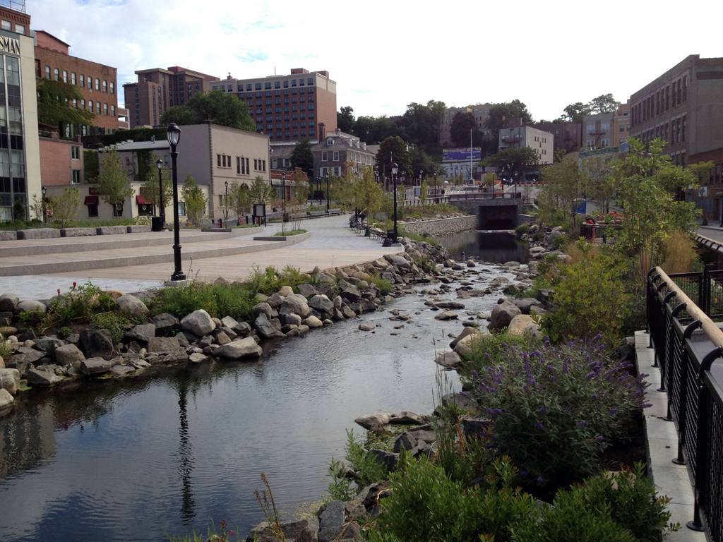
Since breaking ground in December, 2010, the Saw Mill River daylighting project has created 13,775 square feet of aquatic habitat in downtown Yonkers, New York. Future redevelopment phases include a pedestrian courtyard and additional daylighting close to the purple billboard seen in the distance. Photo: Zach Youngerman
The Aztecs constructed artificial islands in the middle of a lake to build Tenochtitlan, present-day Mexico City. In Boston, one-sixth of the total land area is “fill.” City building has always been a process of creating land for development, often modifying nature to do so. The 1811 Plan of New York, so wonderfully presented in an exhibition at the Museum of the City of New York two years ago, demonstrated this imperial expansion up Manhattan Island. A hill torn down. A swamp buried. A bulkhead extended.
How unexpected, then, that over the last twenty or thirty years, cities have been destroying land to make room for water. Seoul has famously taken down a highway to turn the Cheonggyecheon, a previously hidden stream, into a linear park. In Oklahoma City, the government dug up city streets and delivery alleys to create a wholly artificial canal system. Closer to home, the daylighting of the Saw Mill River in Yonkers has accelerated in ambition from excavating a parking lot over the river to demolishing buildings above it.
The destruction of roads and private property to resurrect former watercourses might seem to be the mark of success for the return-to-Eden school of environmental advocates. In Yonkers, environmentalists tout the arrival of blacknose dace, eel, turtles, and blue claw crab to the restored river habitat. And the ecological benefits extend beyond increased biodiversity to include a reduction in urban heat island effect and greater local environmental awareness among residents.
Marit Larson, Director of Wetlands Restoration for the Natural Resources Group of the New York City Department of Parks and Recreation, describes daylighting as “restoring the structure of a stream channel … restoring habitat and then ecological function. It’s a pretty significant action.” Yet in Yonkers and elsewhere, daylighting is better understood in economic terms, as part of a late-20th century urban development trend to integrate retail and residential uses with outdoor public (and private) space. In cities rapidly losing industrial activity, this type of regeneration strategy often couples waterfront redevelopment with the adaptive reuse of adjacent mills and warehouses.

Left: The daylighted Cheonggyecheon stream in Seoul, South Korea, during Buddha’s birthday celebrations; photo by Emily Orpin | Right: Bricktown, Oklahoma City; photo by Serge Melki.
The case studies are numerous and diverse. In his landmark book The American City: What Works, What Doesn’t, Alexander Garvin cites the 1964 renovation of Ghirardelli Square as a progenitor. The well-designed retail center with a panoramic view of the San Francisco harbor translated into both a larger urban experience and a catalyst for urban regeneration. The 1968 World’s Fair in San Antonio preserved two dozen old buildings among a new tourist-scape centered on a small water channel named River Walk.
Developer James Rouse honed this form, which he dubbed a festival marketplace: Harborplace (Baltimore, 1980), South Street Seaport (New York, 1982), and Riverwalk (New Orleans, 1984). Waterfronts became a hot commodity in post-industrial commercial redevelopment projects and anywhere that had water began to capitalize on it. By 1988, this model had reached the heartland. Indianapolis created White River State Park Cultural District around the Indiana Central Canal, a failed infrastructure project of the 19th century and arguably not a particularly remarkable water feature.
All of these massive complex projects involved water that was, simplistically stated, already there. In Providence, Rhode Island, in the 1990s, a river existed, but only in a remote sense; it had been buried for decades beneath the world’s widest bridge of parking and roadways.
Over the city’s history, the odd tidal river on Narragansett Bay evolved from a modest shipping corridor to a foul depository of industrial waste and an inconvenience to development, like so many other rivers across the country. It was reduced in size, moved several times to accommodate railroad stations and, by the 1950s, covered for most of its length.
The idea of returning the Providence River to the open air by removing valuable downtown parking spaces seemed fantastical when Architect William Warner first proposed it in the 1980s. Yet that was exactly what Providence did, at a cost of $60 million. Warner designed multi-level walkways and Venetian-style bridges to bring pedestrians and bicyclists closer to the channelized river. A new circular Waterplace Park was built around the river, anchored by a gigantic, river-spanning mall that delineated the boundaries of the new environment by blocking I-95 and abandoned upriver factories.
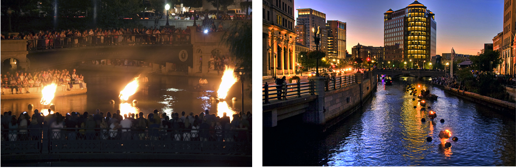
WaterFire in downtown Providence, Rhode Island. Left: photo by Liz West | Right: photo by Heather Katsoulis
When Waterplace Park was finished in 1994, sculptor Barnaby Evans installed floating bonfires in the river that turned the new park into a true attraction. During the Saturday-night event — which has continued since — speakers play ethereal tunes one rung more interesting than Muzak. Dark-clothed stagehands in motorboats keep the theater of the fires going until midnight, while gondoliers offer passengers trips on replicas of Venetian gondolas. A city of fewer than 200,000 people, Providence today draws in an average of 40,000 people during each WaterFire.
While the greatest improvement to area water quality was arguably a $100 million upgrade to the Fields Point sewage treatment plant, the narrative of the Providence Renaissance continues to revolve around the river’s daylighting — and fire-lighting. Led by the charismatic ex-convict mayor Buddy Cianci, Providence of the late 1990s was regularly featured in travel magazines and websites. Companies moved their headquarters from suburban Rhode Island back into downtown. In 1999, the television drama series “Providence” premiered on NBC. In 2000, the census registered an 8% jump in population. The city became symbolic of urban America’s rebirth and the new “creative class” who wanted to live there.
As an overlooked, post-industrial, mid-sized city, Providence was a doppelganger for Yonkers pre-makeover and a believable model afterwards. Yonkers had buried the Saw Mill River, a tributary of the Hudson that flows through the heart of its downtown, in the 1920s. What Yonkers lacked in state-wide stature relative to Providence, it made up for in the form of an enthusiastic Westchester-born Governor, George Pataki. In 2006, Pataki and the state legislature allocated $34 million for daylighting the Saw Mill River.
The results have been transformative. Ann-Marie Mitroff, who was pivotal in generating public enthusiasm and obtaining EPA funding as River Program Director for Groundwork Hudson Valley, says “people are amazed that it wasn’t like this before.” Wilson Kimball, Commissioner of Planning and Development, has called daylighting an economic engine.
Downtown is abuzz with the redevelopment of existing buildings and ambitious new construction. While some of that development is along the Hudson River, where there is a more recent history of private investment, other projects are growing along the re-emerging riverside of the Saw Mill. The most spectacular is a 22-story, estimated $150 million development called Yonkers Rising.
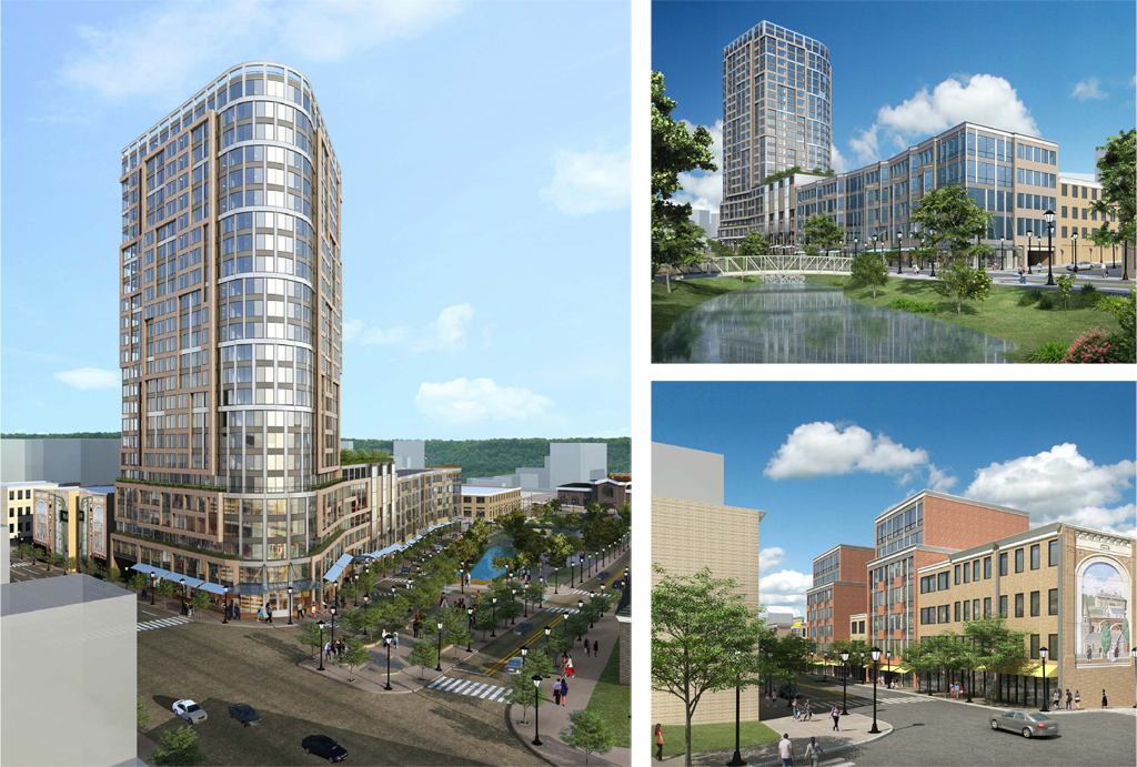
A rendering of the new section of Yonkers Rising adjacent to the daylighted Saw Mill River and Larkin Plaza. Images: Perkins Eastman
Yonkers Mayor Mike Spano, who was elected in 2011 but helped secure funding for the daylighting project as a state legislator in 2006, could not have hoped for better. He describes the strategy behind the daylighting in language reminiscent of Alexander Garvin: “The whole idea of developing the downtown is that you can walk around and that there are public amenities — you can go to restaurants, some of our stores, spend a day walking along the [Saw Mill] river’s edge or the Hudson River waterfront. It’s about bringing people down here, that’s how urban settings have been successful across America.” It is also bringing new business. Tech company Mindspark is expected to open offices downtown with 180 six-figure salary positions.
One of the most amazing aspects of the project is that it is ongoing. “I would imagine that there will be a fourth phase, and there will probably be a fifth and sixth phase of daylighting … so the public can walk along the river’s edge,” Mayor Spano says. For him, the beneficiaries of the daylighting project are the river’s terrestrial neighbors, not its aquatic wildlife. Through the Yonkers Industrial Development Agency and the six-year-old New Main Street Development Corporation, the city is methodically redeveloping each block through or under which the river flows.
But the goals of providing access and spurring development prove more challenging as the project moves upriver. Phase 1 consisted of removing a city-owned parking deck. Phase 2 involves the interior of an oddly pentagonal block which will contain a new courtyard, costing the city about $2.5 million. A narrow alley aptly named Mill Street will be repaved. The city has just finished negotiation with a one-story appliance store that it will tear down to connect the courtyard to the Phase 1 area.
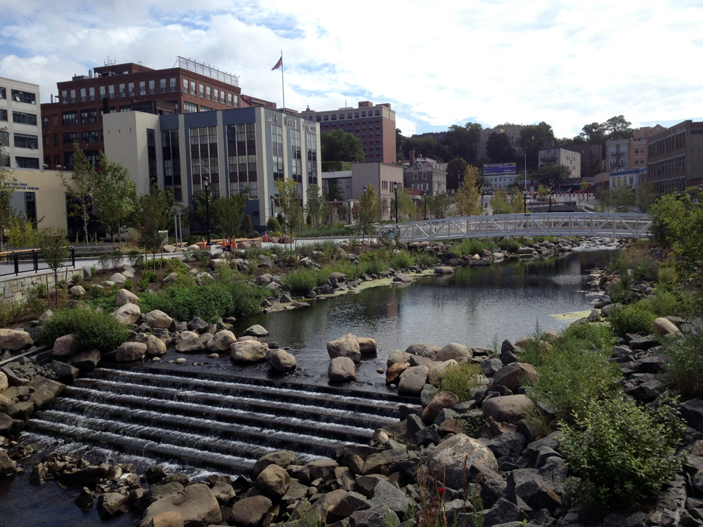
The Saw Mill River | Photo: Zach Youngerman
Upstream from that site, the Saw Mill River runs uncovered in a stone-lined channel, taking up half the width of the block. On the other half of the block, with their backs to the river, are mostly one-story buildings with signs for businesses typical of downtown: Anthony’s Beauty Salon and Barber Shop, J&M Party Supply, East West Gift Shop. With a $8 million grant from the Empire State Development Corporation, the New Main Street Development Corporation has purchased the buildings along the river. The Corporation intends to demolish the buildings to prepare for a larger development.
In the meantime, the City of Yonkers is honoring the leases of existing tenants, although it has raised the rent, according to Hasan Abutin, the owner of Main Street Furniture Store. Of the twelve businesses on the block, five have closed; only some have reopened elsewhere, according to Abutin, and without city help. His shop at 151-B New Main Street is just 15 feet wide, surely not the scale or intensity of business which merits the expression “economic engine.” Plans and renderings show the block joined to an adjacent one to create a new mega-retail complex. The developer’s website describes a “commercial / entertainment component … anchored by residential tower pad sites (maximum buildable heights of 400 feet).” Before the market crashed, three companies created a new firm, Streuver Fidelco Cappelli, with the intention of building a minor league baseball stadium here along with daylighting a 230-foot section of the river. That project was a large component of what Yonkers officials touted as the $3.1 billion reinvestment in downtown. While SFC has stalled and asked for an extension of tax incentives on the project, the city is finding ways to continue development and daylighting of the site.
New York City has several buried rivers, but few are perhaps as shovel ready for restoration and new development as the Saw Mill River. One potential site is Mill Creek and the former Flushing Airport south of College Point, Queens. It was targeted by the New York City Economic Development Corporation in the early 2000s, but residents and their local representatives quashed what was seen as too large a commercial project in a small-town-feel neighborhood. Marit Larson told me that Mill Creek is potentially “a great opportunity for wetland restoration accompanying restoration of the stream channel.”
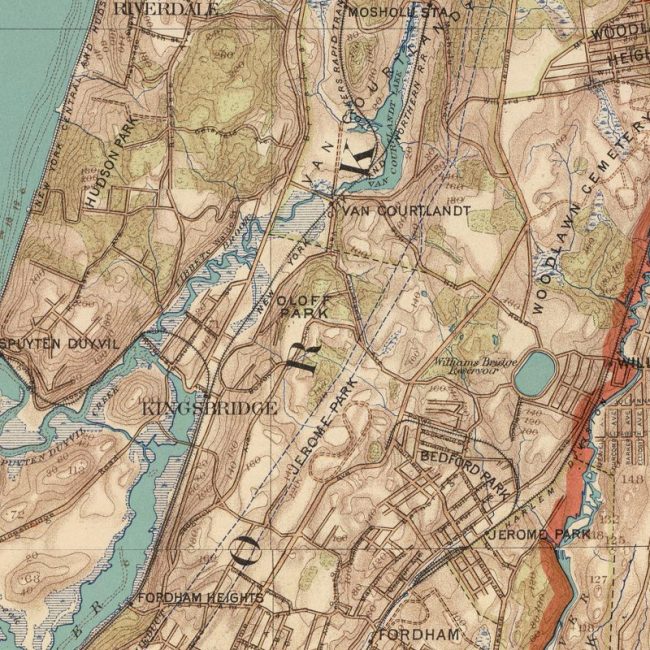
Excerpt of an 1890 map, “Long Island Sound, Westchester north to Mt. Vernon, Queens south to Jamaica,” which shows the original route of Tibbetts Brook as it flows into Spuyten Duyvil Creek between the Hudson and Harlem Rivers. To access the entire map in full resolution, scroll down to the embedded version below. Copyright: Julius Bien and C.C. Vermeule, 1890. Map is currently in the David Rumsey Map Collection. Click on the image above to visit the collection.
Another body of water that has a chance of being daylighted is Tibbetts Brook in the Kingsbridge neighborhood of the Bronx. Similar to the Saw Mill River, Tibbetts has a substantial watershed that starts in Westchester and is uncovered for most of its length. According to Larson, that upstream health is an advantage in a daylighting project: “Whatever action you take — say, daylighting 200 feet of stream – if that’s at the end of a heavily impacted many-square-mile watershed, the stream can only do so much with the water that’s brought into it.”
But the real environmental appeal of daylighting Tibbets Brook is not its upstream condition, but its downstream impacts. Whereas the Saw Mill flowed through a flume into the Hudson River, Tibbetts Brook flows in pipes right into the sewer system. This means that the Department of Environmental Protection (DEP) has to treat the brook as it would treat water flushed down the toilet. During wet weather, though, DEP is unable to handle the volume of sewage, rainwater, and brook flow, and the combined mixture overflows untreated into the Harlem River Ship Canal. As DEP works to meet water quality standards, diverting Tibbets Brook from the sewer is a high priority.
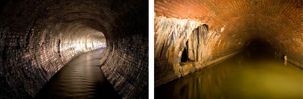
At the southern end of Van Cortlandt Park, Tibbetts Brook flows into a brick tunnel and then into an arched brick sewer underneath Broadway in the Bronx. Urban historian and photographer Steve Duncan has been exploring the hydrology of New York and other cities through sewer expeditions for years. For more on Duncan’s work (and its implications for daylighting underground streams) click here. Left: Tibbetts Brook, Bronx; right: Broadway or Tibbetts Brook Sewer, Bronx. Photos: Steve Duncan.
So where exactly would Tibbetts Brook be daylighted? The first answer is within Van Cortlandt Park itself. Larson says that there is a little bit of room to the west of Van Cortlandt Lake where the stream formerly flowed. “There is a wetland. That is the old topography and the remnant landscape of where the stream used to go.” Lloyd Ultan, Bronx Borough Historian, says that Tibbetts brook has been “reasserting itself downstream of the lake. If you go to that area of Van Cortlandt Park today, you’ll find a lot of marsh vegetation.”
The second answer is between the Park and the Harlem River Ship Canal. A former railway track, the Putnam line of the New York Central Railroad, runs parallel to the Major Deegan Expressway. The section that runs through Van Cortlandt Park is already called the Putnam Trail, and the right-of-way continues south of the park alongside Putnam Avenue West, a path that has been planned as a greenway for sometime. “It is not the precise historic path of the stream,” says Larson, “but that area is complex and there are most likely historic wetlands and drainage ways along the path to the river.” Plans for both possibilities are in their early stages: the Parks Department is inviting public comment on its draft master plan for Van Cortlandt Park, which details the potential of daylighting Tibbetts Brook, and both Parks and DEP are studying the properties and rights-of-way along which the restored stream might flow.
Besides the technical challenges, Larson describes programmatic challenges. DEP has funding for some parts of the project to divert Tibbetts from the combined sewer overflow, but not others. Working with property owners and developers to integrate a new daylighted Tibbetts Brook into a walkable, mixed-use project may be a mutually beneficial negotiation. Not surprisingly, current real estate development projects do not view the weed-filled former railway as an amenity. A narrow strip of land in the shadow of the Deegan does not scream development potential, but then a Yonkers renaissance or a park on the High Line once seemed pretty far-fetched, too.
The views expressed here are those of the authors only and do not reflect the position of The Architectural League of New York.
Comments