
Celebrate ten years of Urban Omnibus and support ten more years of fresh, independent perspectives on citymaking with a donation today!
Celebrate ten years of Urban Omnibus and support ten more years of fresh, independent perspectives on citymaking with a donation today!
New waterfront parks and all manner of development keep bringing New Yorkers closer to the Hudson River, while the threat of storms and sea level rise make life in a river city more perilous than ever. As we’ve extracted value from the Hudson — from the oyster shells ground up to make mortar in the nineteenth century to the scenic views that fuel real estate development today — we’ve changed the environment as well. That idyllic waterway is also a Superfund site, lined with toxic chemicals. The painters of the Hudson River School saw this paradox almost two centuries ago, meditating on the costs of progress on a river that provided an Arcadian escape from life in the modern city at the same time that it was mined for raw materials to build it. The Hudson, and its role in defining the relationship of humans and the natural world, is the subject of a wide-ranging exhibition on view at the New-York Historical Society through August 4, 2019. Below, Jeanne Haffner, curator of the exhibition with Marci Reaven, gives us a tour of the conflicts that have shaped the river from its source in the Adirondacks to New York City’s Lower Harbor, and recounts how the Hudson’s beauty and ecological complexity have inspired efforts to conserve it.
In 1866, the historian, journalist, and illustrator Benson Lossing crafted a love letter to the Hudson River. This body of water, running over three hundred miles “from the Wilderness to the Sea,” was unparalleled in “the beauty and magnificence of its scenery, its natural, political, and social history, the agricultural and mineral treasures of its vicinage, the commercial wealth hourly floating upon its bosom, and the relations of its geography and topography to some of the most important events in the history of the Western Hemisphere.” In short, Lossing concluded, the Hudson was “by far the most interesting river in America.”
New Yorkers, perhaps more than anyone else, should find particular interest in this river and its history. The city owes not only its wealth and cultural dominance, but its very existence, to the Hudson. The richness of the Hudson estuary allowed first Native Americans and later colonialists to settle and thrive in the harbor in the first place; materials brought from upriver towns, such as bricks, stones, concrete, and iron, literally constructed New York City.
If the Hudson has served such practical needs, it has also provided a scene for deep reflection on the relationship between humans and the nonhuman world. In the 19th century, sawmills, tanneries, iron mines, and other industries transformed the landscape as they took advantage of the river and its surroundings. Artists, writers, and scientists posed questions about the moral, economic, and ecological consequences of such “progress.” Humans have the ability to shape the natural world to an extreme degree, these critics realized, but should this power be embraced or shackled? This question is fundamental to contemporary debates around the Anthropocene, a term that describes the acceleration of human impact on the earth in the last 200 years since the emergence of fossil fuels and steam power. Over the course of this period of dramatic environmental change, the Hudson has been a key site for witnessing, conceptualizing, and reimagining humans’ transformation of the earth.
The 19th-century Hudson was a conduit for people and goods: Steamboats brought immigrants, tourists, workers, artists, and writers upriver, and materials such as bricks, lumber, stone, and ice down to New York City. The ecological abundance of the Hudson estuary, where fresh water flowing down from the Adirondacks meets saltwater rushing up from the sea, provided the ideal habitat for oysters, which fed a growing urban population. Oyster shells, too, were useful to the burgeoning city, ground up to make mortar to hold bricks and stones together. Paradoxically, the river provided both the foundation for the city’s economic and cultural dominance in the 19th century and a way for urban elites to escape the less appealing aspects of their own creation in estates and hotels upriver.
For those who did not have the means to reach such destinations physically, artists and writers offered access to the fantasy of pastoral life along the Hudson. As the American Art-Union declared in 1846, “to the inhabitants of cities…a painted landscape is almost essential to preserve a healthy tone to the spirits, lest they forget in the wilderness of bricks which surrounds them the pure delights of nature and country life.” One of the most prominent painters of the Hudson was Thomas Cole, who, with his contemporaries in the Hudson River School of painting, offered scenes of an imagined rural life that starkly contrasted with a polluted and overcrowded city.
Appealing to the spiritual and symbolic aspects of the Hudson landscape and its natural history, Cole raised questions about land use, land ownership, and the survival of rural ways of life. The message of his panoramic series of five paintings, Course of Empire, which he completed in the 1830s, is unmistakable: Left uncontrolled, economic progress leads to ruin. On three large canvases, Cole first depicts the rise of a thriving city out of a pristine landscape. Dark green hills and Native Americans disappear as architecture and science conquer the natural world. The final two paintings, just as grand as the rest, chart the decline and fall of this urban civilization.
Thomas Cole’s Course of Empire (1858). Images courtesy of New York Historical Society
The outcome of the American quest for “progress,” Cole warned, was a landscape of ruins and desolation. In an 1836 essay, he connected this moral narrative to the changes he witnessed along the Hudson from his home in Catskill. Industries such as tanning and lumbering were destroying the area’s trees and polluting its streams in the pursuit of profit. “I cannot express my sorrow,” he wrote, “that the beauty of such landscapes are passing away…another generation will behold spots, now rife with beauty, desecrated by what is called improvement.”
While Cole held industrialists responsible for this destruction, some New York City businessmen, in fact, secured the success of early conservation efforts along the Hudson. In the Adirondacks, where the source of the Hudson is located, New York-based speculators would buy up land, remove all the lumber as quickly as possible, and then leave the state to recuperate the land for unpaid taxes. The piles of dead brush and timber they left in in their wake often started forest fires, leading to even more deforestation. In 1864, the lawyer, diplomat, and former Vermont Congressman George Perkins Marsh warned of the consequences of such practices. When trees are destroyed, he wrote in Man and Nature: Or, Physical Geography as Modified by Human Action, the ground loses its ability to hold moisture, and the disturbed ground becomes more susceptible to erosion. Deforestation threatened entire watersheds, impacting commerce, navigation, and public water supplies. This posed quite a threat to a city that largely depended on shipping to and from the Erie Canal.
Like Cole, Marsh’s message was moral and philosophical. He drew attention to the capability of humans to destroy their own civilization — even while they think they are “improving” it. “The human race,” Marsh observed, “seems destined to become its own executioner.” Yet Marsh used the language of science rather than art, drawing on textual evidence and concrete observations from his European travels. In the 1870s and 1890s, severe droughts gave his warnings credence.
Inspired by the same sense of foreboding, surveyors and forestry experts mapped and measured forested land in the Adirondacks, ultimately outlining the area necessary to protect the source of the Hudson. The possibility of inadequate water levels in the Hudson alarmed the powerful men involved with the New York Board of Trade and Transportation and the New York City Chamber of Commerce, who ultimately induced the New York State Legislature to take action. The Forest Preserve was created in 1885 out of state-owned land in the Adirondacks; Adirondack Park was created in 1892 by adding surrounding private lands; and in 1894, the New York State Legislature amended its constitution to prohibit logging on state lands within the park. This act became known as “Forever Wild,” an important precedent for large-scale land conservation projects in the 20th century.
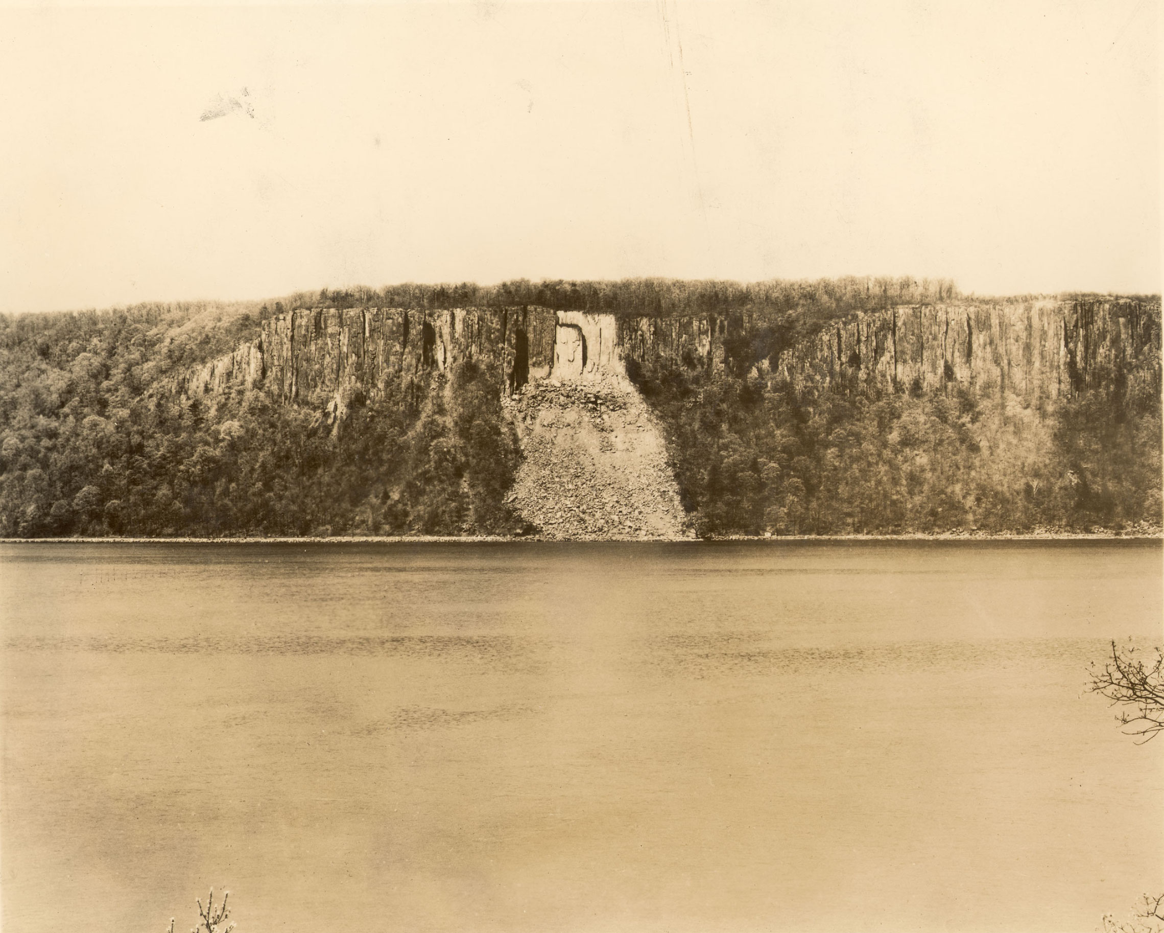
Across the river from New York City in the Palisades, activists sought to preserve land that could provide a scenic antidote to the city, and recreational space for growing urban and suburban populations. The cliffs of the Palisades were an icon in Hudson River School paintings. Late-19th-century quarry operators, however, began to blast the cliffs for trap rock, which was used to build New York City streets, piers, and the foundation of skyscrapers. For many citizens in New York and New Jersey, this constituted the destruction of not only an ancient geological structure, but also the moral and societal values associated with scenic beauty. Opponents to the blasting often described the ruination of the Palisades as an affront to civilization itself.
In the mid-1890s, women conservationists in New Jersey brought attention to the destruction of the forests of the Palisades as well, warning of impact of deforestation on the state’s water supplies. Other activists focused more on the threat to nature’s symbolic value, and joined forces with wealthy businessmen across the river. Members of the New Jersey State Federation of Women’s Clubs lobbied Governor Foster Voorhees, and the New York side secured Governor Theodore Roosevelt’s support for the creation of a unique bi-state agency, the Palisades Interstate Park Commission, in 1900.
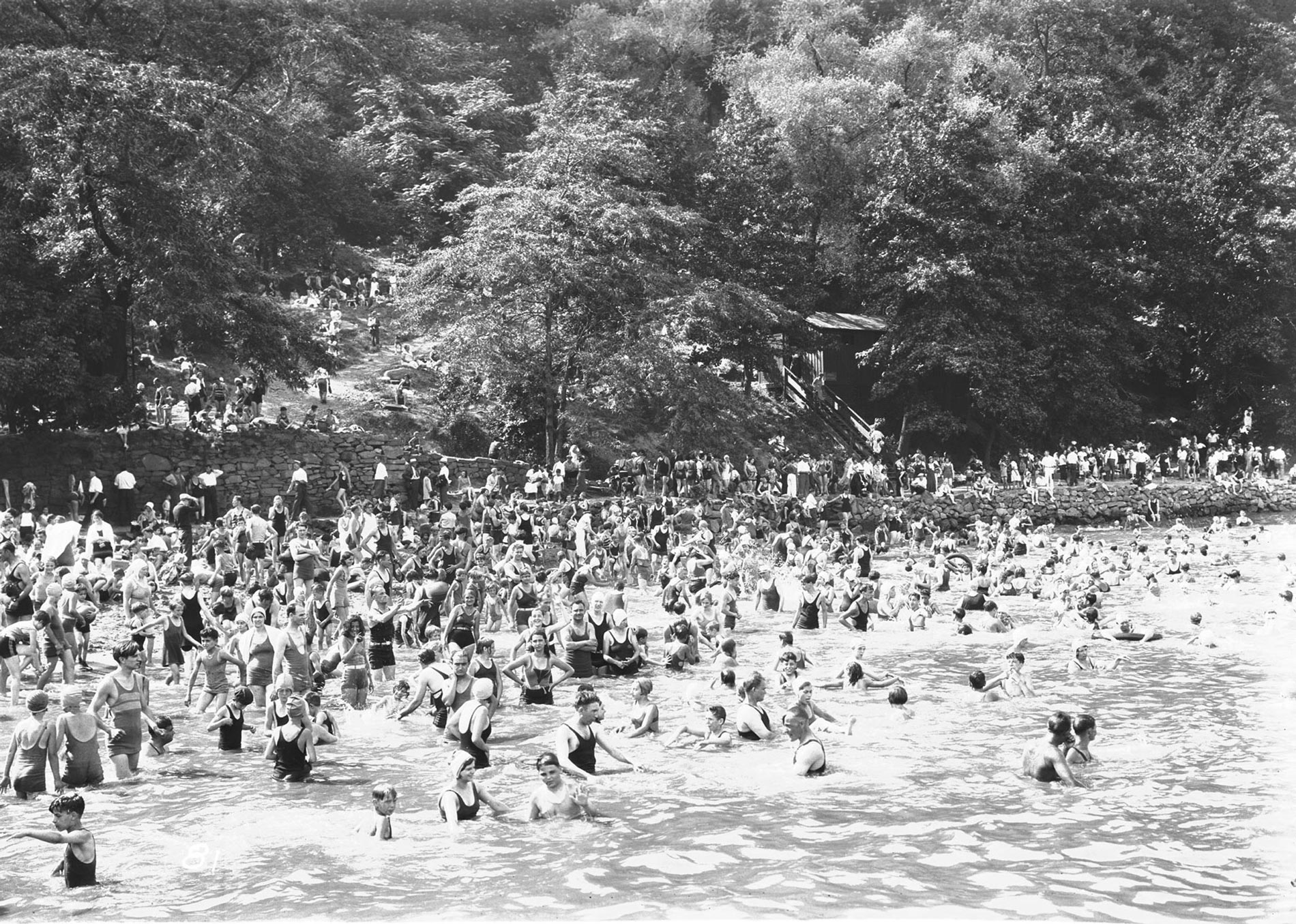
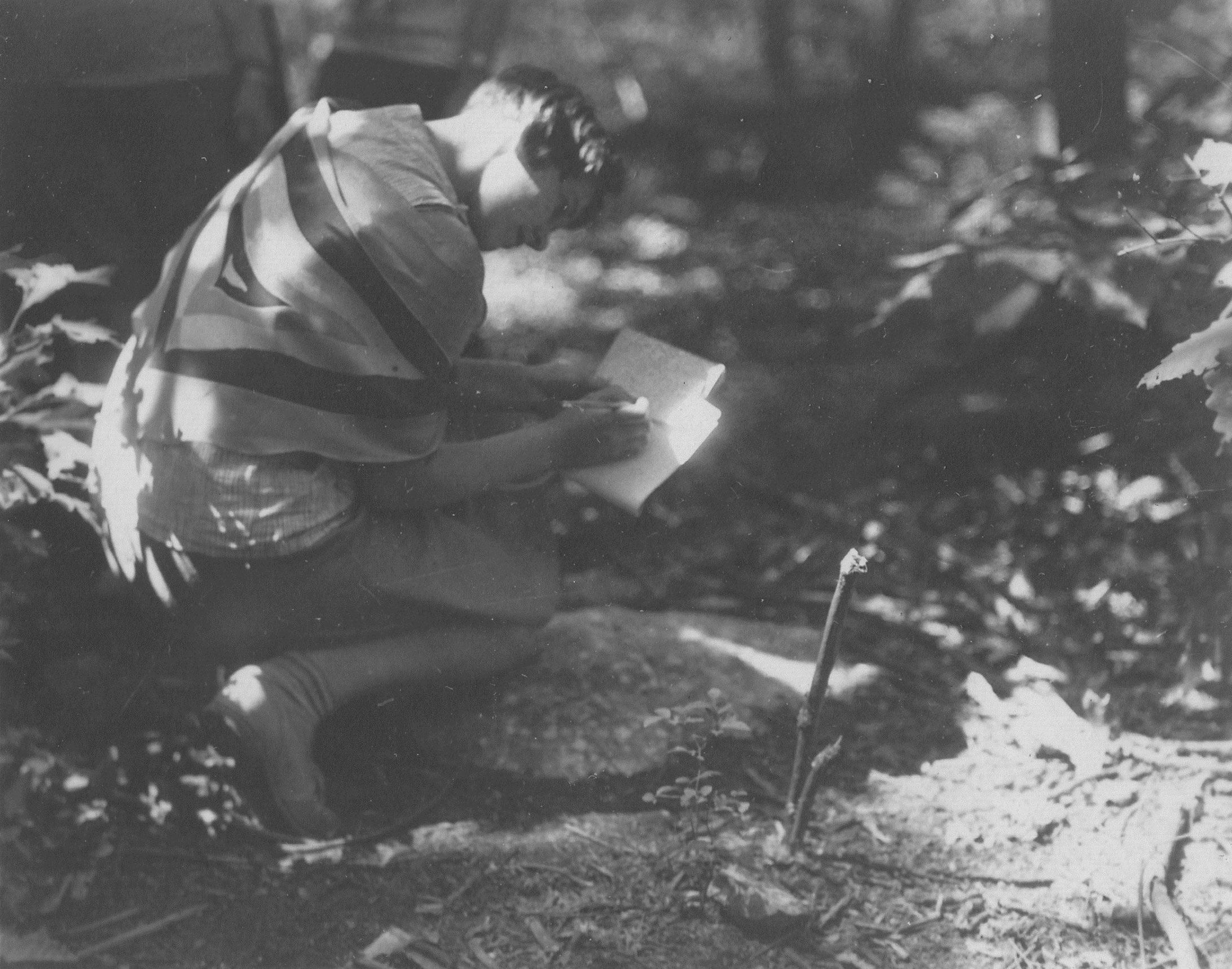
The opening of Palisades Interstate Park in 1909 transformed the Palisades from a landscape of resource exploitation to one of recreation and environmental education. Early on, a free ferry from Manhattan took children and adults to the park, which offered an escape from city life. Children and teenagers participated in nature camps and examined flora and fauna specimens at the Trailside Museum, established in the late 1920s. Visitors hiked through the woodlands. In summer, they often filled the park’s swimming areas to capacity. At the end of their stay, city residents returned home with a new appreciation for nature of all kinds.
As the popularity of Palisades Interstate Park grew in the 1930s, 1940s, and 1950s, so too did the region. The automobile age brought new types of infrastructure — from the George Washington Bridge and Lincoln Tunnel to highways — and fueled suburban fantasies. Driving over the river, or passing it on a train, park visitors and others were shielded from the reality of water pollution from toxic industries, consumer waste, and sewage. In 1943, the last public beach in Palisades Interstate Park closed, in part due to pollution. In 1964, US Secretary of the Interior Stewart Udall traveled up the Hudson River and called it an “open sewer,” a description that captured the river’s stench as well as its unsightly condition. It would take a crisis to bring people back to this polluted waterway, and reignite a widespread passion for the river’s beauty.
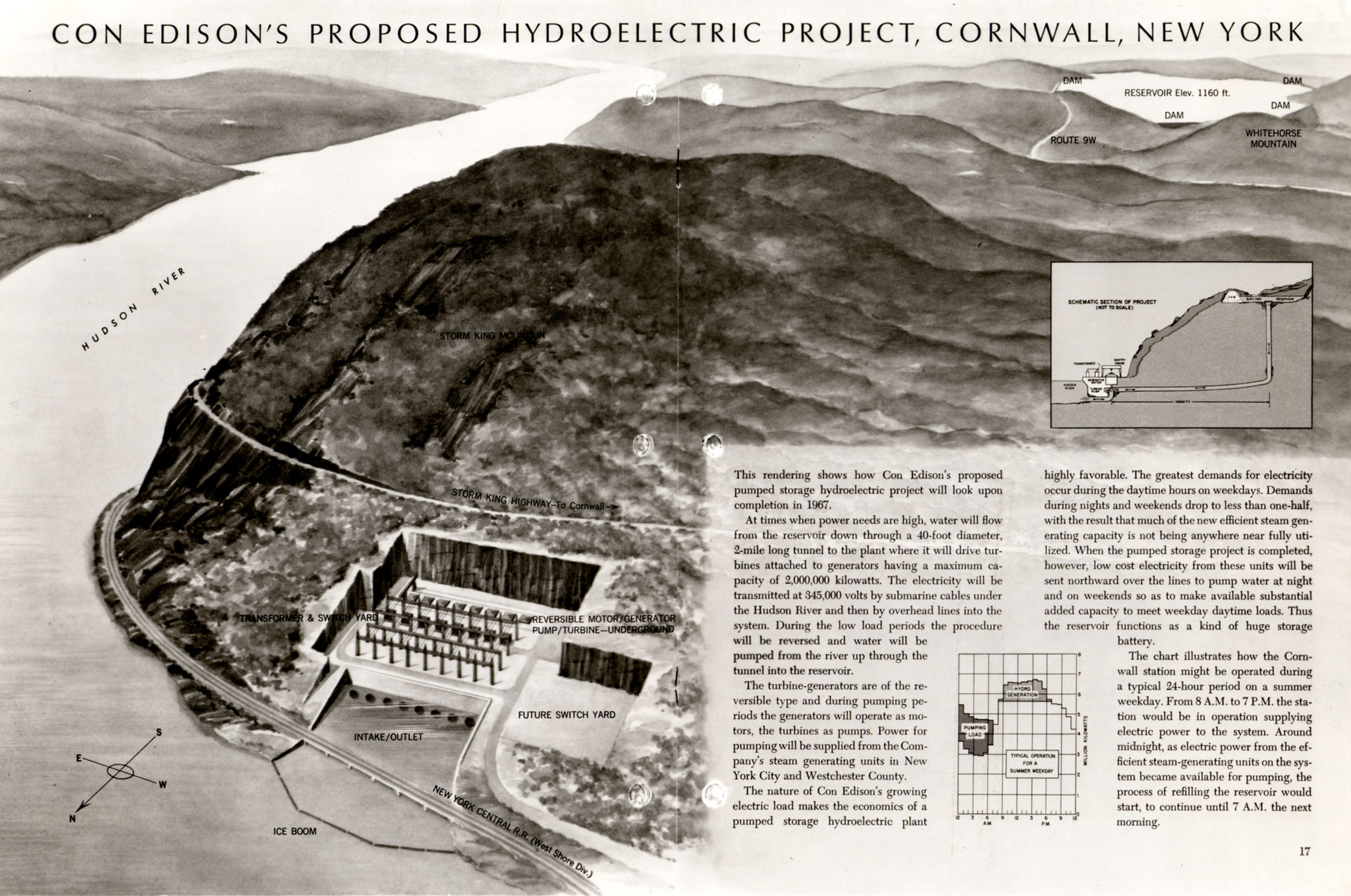
By the 1960s, New York City’s population had grown to almost eight million. To power the metropolis, Consolidated Edison, Inc. applied to the Federal Power Commission for a license to construct a hydroelectric storage plant in the Hudson Highlands in 1962. Early documents featured an unforgettable image: The plant inserted into the side of Storm King Mountain, in a hole created for the purpose. For some, Con Ed’s promise to develop the riverfront of Cornwall, where the mountain was located, was tempting. Others were indignant that Con Ed could even conceive of such an intervention in the first place.
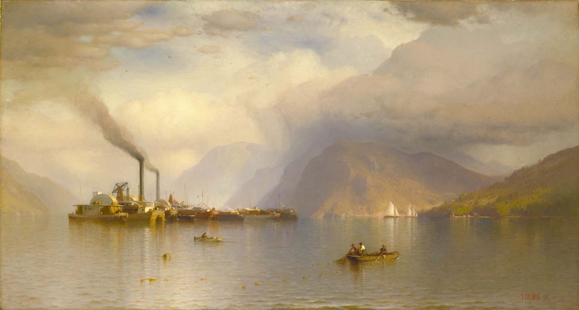
In 1963, a group of citizens gathered at the Irvington home of Carl Carmer, a writer and historian whose popular 1939 book, The Hudson, vividly captured the Native Americans and workers who lived and worked along the river everyday but did not own the land. Now, Carmer led a circle of activists — known collectively as Scenic Hudson — to protect land that was not their personal property, but which, they believed, belonged to all. At hearings that extended over 17 years, lawyers called upon art historians such as Vincent Scully and Barbara Novak to testify to the site’s cultural value. In the 1970s, Scenic Hudson director Franny Reese persuaded John Howat, a curator at the Metropolitan Museum of Art, to publish a book on the Hudson River School, the proceeds of which would support the case. The book, which included Samuel Coleman’s 1866 Storm King on the Hudson, revived interest in a school of painting that had been broadly forgotten.
While Scenic Hudson’s fight for the site’s intangible values did not win the case, it proved persuasive in the both the New York Court of Appeals and the court of public opinion. In 1965, three presiding judges ruled that the Federal Power Commission had to reconsider Con Edison’s license request, and that the “renewed proceedings must include as a basic concern the preservation of natural beauty and national historic sites, keeping in mind that in our affluent society, the cost of a project is only one of several factors to be considered.” The plant’s impact on such intangible values was just as important as its impact on fisheries, and all had to be properly assessed. This requirement was institutionalized in the National Environmental Policy Act of 1969, which mandated that all license applications at the state and federal levels include an environmental impact statement (EIS). Second, the court ruled that citizens are able to sue on behalf of land that they do not own. According to historian David Schuyler, these decisions “revolutionized environmental law” in the United States.
Ultimately, the Storm King case was won by appealing to science rather than art. In response to the court’s request for an impact statement, Con Ed revised its initial plan, proposing to place the plant underground. This may have quieted discussions about its visual impact, but brought other issues to the surface, most notably the plant’s impact on the river’s striped bass populations. Journalist and fisherman Robert Boyle challenged Con Ed’s in-house fish studies, demonstrating that many more fish would be impacted by the project than initially assessed. Bolstered by mathematical figures, Boyle’s fish studies proved more convincing than arguments focused on the site’s scenic and historical significance.
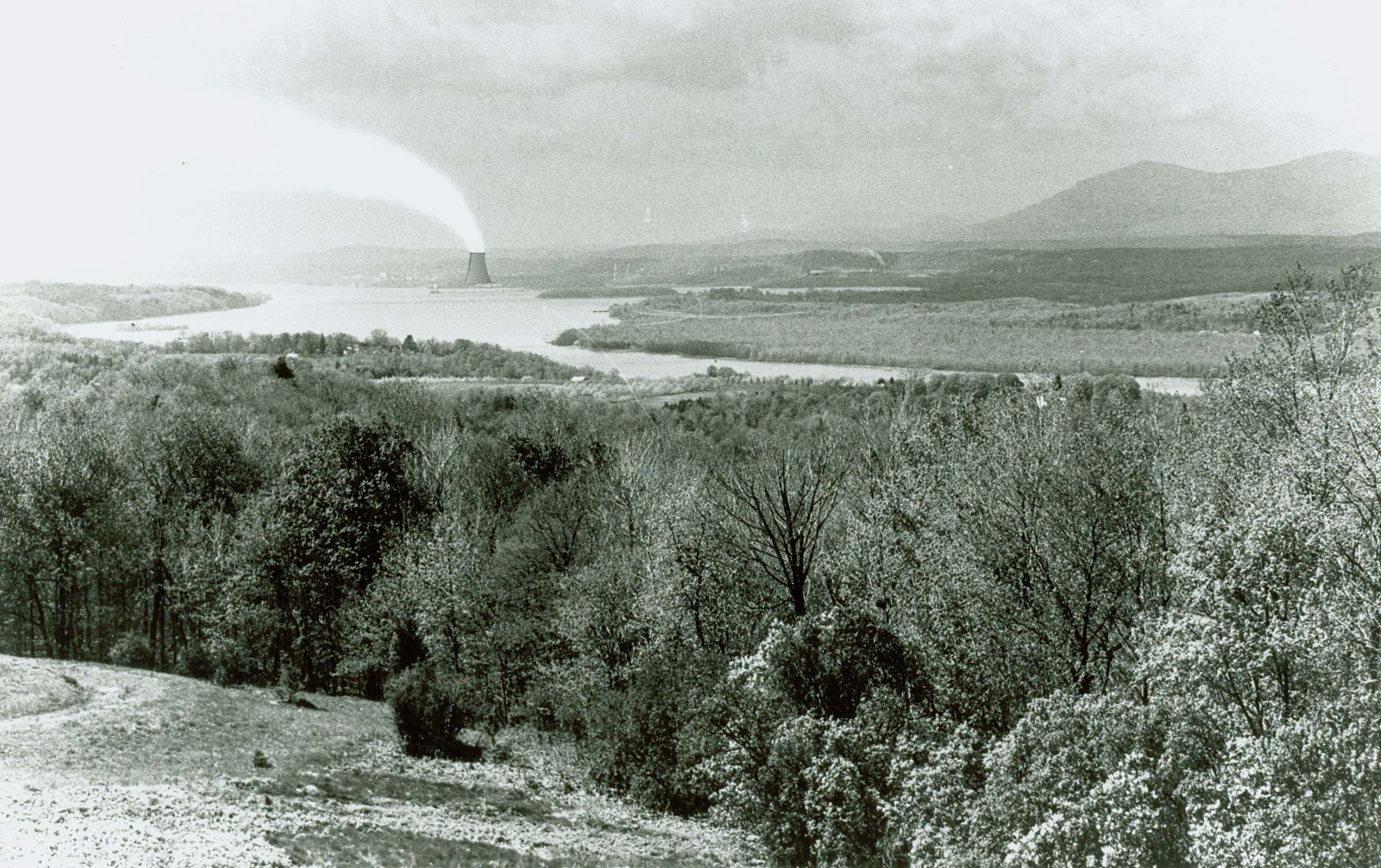
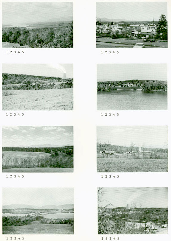
In subsequent lawsuits, however, the subjectivity of scenic beauty too could be quantified, bringing it on par with measurable ecological effects. In 1979, a nuclear power plant was proposed across the river from Olana, the historic home of Hudson River School painter Frederic Church. In the EIS, landscape architect Carl Petrich of Oak Ridge National Laboratory and Harvey Flad, a cultural geographer based at Vassar College, superimposed images of the proposed plant on pictures of the view from Olana. They sent these images, paired with photos of the same site without the plant, to local residents and asked them to rate the visual appeal of each on a scale of one to five. These “visual preference surveys” compelled the courts. At the same time, during the hearing process, legislators were shown one of Church’s paintings of the view from Olana as evidence of the scenic and historic value of the Olana “viewshed.” The view, and all the values associated with it, had finally come into its own as a tool in conservation.
The Hudson today is a much cleaner river, as a result of citizen activism and legislation of the 1960s and ‘70s. The Clean Water Act of 1972 required the construction of sewage treatment plants — ones that don’t just remove solids but decontaminate the water with the aid of chemical processes — and prohibited discharging pollutants without a permit. It also placed regulations on filling in wetlands, which filter water and provide habitat and spawning grounds for fish, plants, and birds. Efforts to restore the river’s health bolstered the return of the Hudson in public consciousness. Since the 1960s, postindustrial towns and cities along the Hudson have reimagined their connection to this historic waterway and undertaken projects to restore shoreline habitats. Industrial riverfronts have become waterfront sites for recreation, environmental awareness, and education.
While the water itself is safer overall, the Hudson has not returned to a prelapsarian state. Sewage treatment plants and regulations on pollution discharge from identifiable sources cannot fully address runoff from city streets and parking lots, or Combined Sewer Overflows (CSOs) during storm events. The Hudson riverbed and surrounding floodplains face yet another problem, that of contamination from Polychlorinated Biphenyls, or PCBs. From the late 1940s to the 1970s, General Electric used PCBs, an insulating chemical agent invented by Monsanto, at two plants upriver. While PCBs prevented electrical fires, they poisoned the river. Unlike other types of pollution, the presence of PCBs is virtually undetectable to the naked eye except in high concentrations, where it resembles drops of motor oil. The discovery of PCBs in the Hudson led the federal Environmental Protection Agency (EPA) to declare 200 miles of the river, from the Battery to Hudson Falls, a Superfund site — a designation reserved for the nation’s most contaminated areas. Between 2009 and 2015, GE dredged 40 “hotspots” in the river close to the plants to fulfill their mandated cleanup requirement. But the EPA and New York State Department of Environmental Conservation continue to test riverbed samples taken further downriver and in the surrounding floodplains.
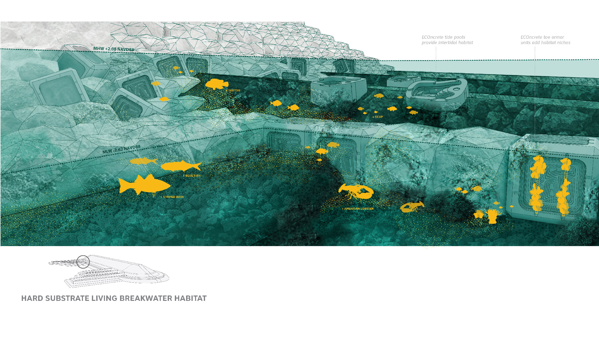
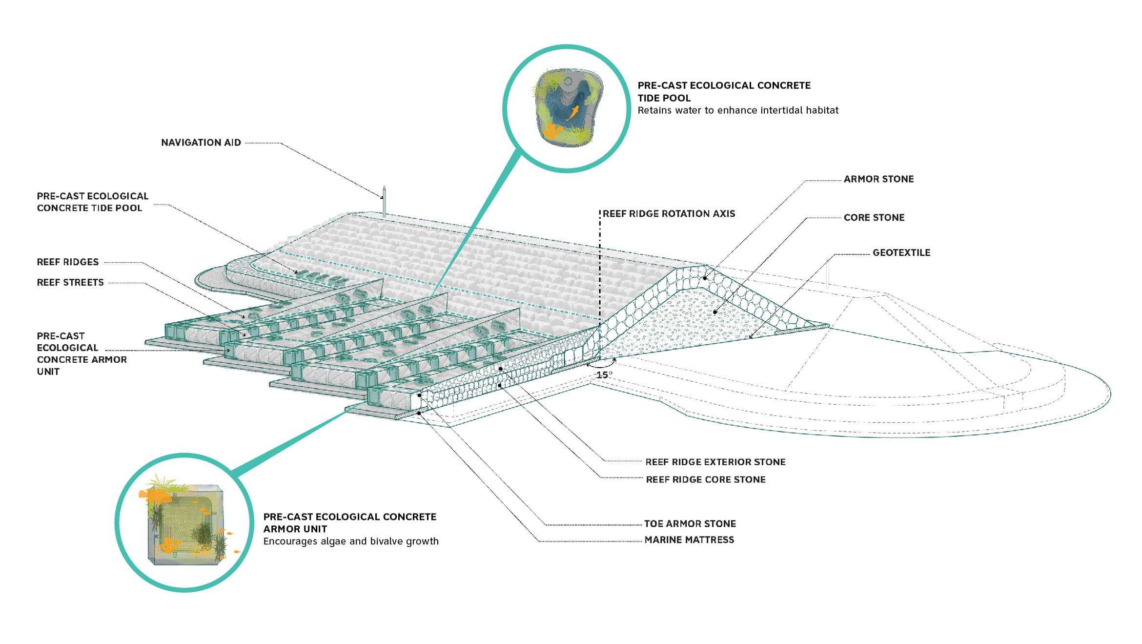
Flooding from storm events and rising sea levels has dominated public discourse along the Hudson since it was hit by Hurricanes Irene and Sandy in 2011 and 2012. Municipal and state agencies are still repairing infrastructural networks damaged by severe flooding, while working to prepare for future storms. Rather than mourning a paradise lost, landscape designers and others have largely embraced the extent to which humans are capable of shaping the world around them, using this power to try and construct not only new landscapes but also novel ways of thinking and relating to the nonhuman world. A design for shoreline restoration off the coast of Staten Island, Living Breakwaters, by SCAPE Landscape Architects, is a prime example. The plan centers on a series of specially-designed breakwaters to reduce the impact of waves during a storm and augment biodiversity in the Lower Harbor: Oyster gabions spur the creation of oyster reefs, which provide habitat for hundreds of species of plants and fish. Deep swirls carved into the concrete blocks that make up the breakwaters offer fish places to hide and spawn. If Hudson River School paintings focused on the Hudson’s scenic beauty, the design of Living Breakwaters highlights the sublime beauty of ecological processes.
The extent of humankind’s impact on the earth, and on the Hudson, is undeniable. Today, Lossing’s “most interesting river in America” is one of the most studied bodies of water in the world. Conscious of the river’s enduring importance for the flourishing of human and nonhuman life, scientists and citizens monitor it closely, their efforts sustaining a delicate balance of use and conservation. There is, perhaps, no better place to contemplate the power of humans to desecrate nature and to rebuild it.
The views expressed here are those of the authors only and do not reflect the position of The Architectural League of New York.

Comments