
We are celebrating 15 years — and counting — of stories that are deeply researched and deeply felt, that build a historical record of what the city has been.
We are celebrating 15 years — and counting — of stories that are deeply researched and deeply felt, that build a historical record of what the city has been.
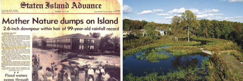
The ecology of southern end of Staten Island, otherwise known as South Richmond, is unique in New York: a ridge of rocky hills slopes to a vast network of freshwater wetlands, kettlehole ponds, streams and creeks that drain into the Atlantic Ocean. South Richmond’s settlement patterns are also unusual: starting in the boom years of the 1920s and accelerating rapidly after the construction of the Verrazano-Narrows Bridge in 1964, residential neighborhoods sprouted up in advance of the kind of urban sewage infrastructure found elsewhere in the city. By the 1980s, the lack of underground pipes for sanitary and stormwater sewers had led to failing septic systems, degraded water quality, erosion and flooding. The solution to this problem, twenty years (and counting) in the making, is an inspiring case study of coordinating infrastructural imperatives with ecological priorities.
Dana Gumb has been working on the Staten Island Bluebelt since 1988. He started first with the Department of City Planning and then went on to lead the Bluebelt project at the Department of Environmental Protection (NYC DEP), the agency responsible for the City’s water supply — that’s 1 billion gallons a day, 7,000 miles of water mains and 7,400 miles of sewer lines. NYC DEP started acquiring property for the Bluebelt in the early 1990s and since 1995 has worked with the water engineering firm Hazen and Sawyer alongside teams of consultants ranging from environmental planners to archaeologists to architects. In the interview below, Gumb sketches out an overview of how the project has evolved. And he reveals how the project goes way beyond stormwater control, probing the intersections between land use planning, environmental engineering, improving public health, providing open space and sustaining biodiversity. –C.S.
What is the Staten Island Bluebelt project and how did it come to be?
In the mid-1970s, Staten Island was in the midst of a huge wave of development and it lacked the infrastructure to support it. Specifically, storm drainage and sanitary sewers. Some creative thinkers working in the Department of City Planning at that time recognized that a lot of wetlands were still in existence. A wetland is an area that is inundated for a certain period of time during the year, frequently enough that its soil and vegetation can thrive under water. So, rather than building a costly conventional storm sewer system — especially costly when you are dealing with a low density, suburban development — some visionary city planners decided to use the wetlands for purposes of stormwater control.
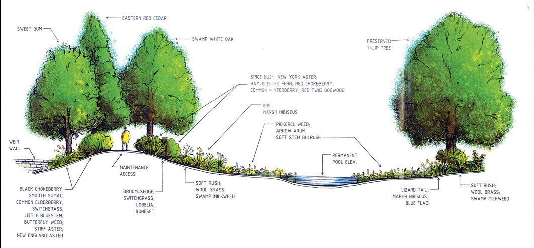
Basically, the Bluebelt project is trying to replicate the pre-development hydrology of these wetland systems. In the 10,000 years since the last glacier, Wisconsin, retreated from the area and left the current topography and watersheds in its wake, Staten Island has mostly been the site of forests, meadows, maybe a few farms here and there, but basically nothing that was too much for the stream to handle. These days, instead of forests and farms you have roadways and rooftops. So, you don’t get the infiltration of the storm water into the ground any more. You get much more runoff, which, at its peak, becomes a big slug of water that arrives at the stream all at once. What we are trying to do is to hold that water back in extended detention ponds and then slowly release it. That way, instead of this flash flood situation, where the water bursts down into the creek system and ruins it, we are able to control flooding and preserve the stream system as much as possible.
A lot of the areas that we clean up and and where we create wetlands haven’t seen a positive measure since European settlement on Staten Island. Our process combines stormwater management with natural area restoration so we get a bunch of benefits in one go: flood control, water quality improvement and a new natural area for birds, aquatic life and, in some cases, park access for citizens.
We didn’t call it “green infrastructure” at the time that we started this. But the idea of “stream valley parks” – linear, open space systems that reach into communities while providing drainage service for flood prone areas – is an urban planning concept that goes way back. Frederick Law Olmsted’s plan for the Emerald Necklace in Boston follows the same basic idea. In Staten Island in the ’70s, some basic assets were there to begin with: Staten Island is the last frontier of freshwater wetlands in New York City.
At the time, were there other examples of using wetlands to deal with stormwater elsewhere in the country? Or was this idea something we had forgotten about since the days of Olmsted?
The concept of a “stream valley park” was around, especially in other suburban areas. The cutting-edge aspect that distinguishes the Bluebelt program from earlier projects is this concept of BMPs – Best Management Practices. When we say Best Management Practices we are talking about best practices in the management of stormwater, in controlling the quality and quantity of the water runoff that eventually finds its way into the stream system and the receiving waters.
Wetlands are the planet’s kidneys. Our goal is to re-introduce wetlands disturbed by Staten Island’s development.
Typically, in other systems, the drainage mechanism is just a simple storm sewer — one that just dumps the water into the stream system. This approach is limited for two reasons. In terms of quantity control, it means you get these slugs of stormwater traveling through the stream system at high velocities, causing stream banks to collapse, the streams to fill with sediment and the eventual loss of the streams’ capacity to convey water. In terms of quality control, you get all sorts of contaminants washing off street pavements and rooftops and making their way into the stream system.
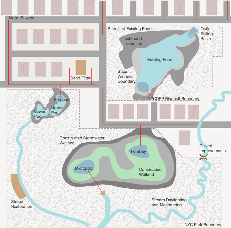
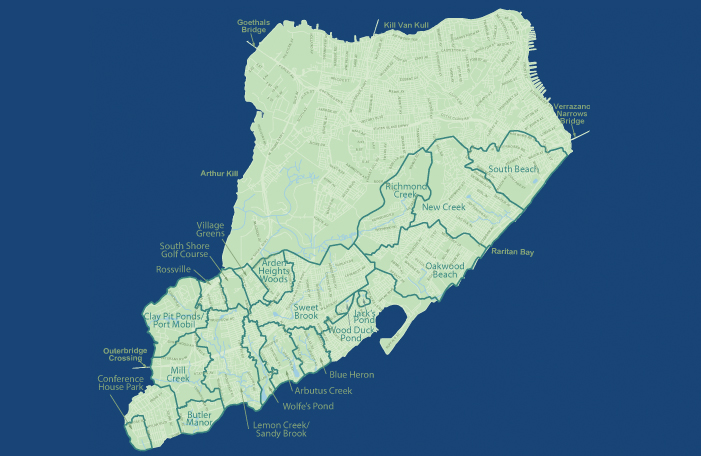
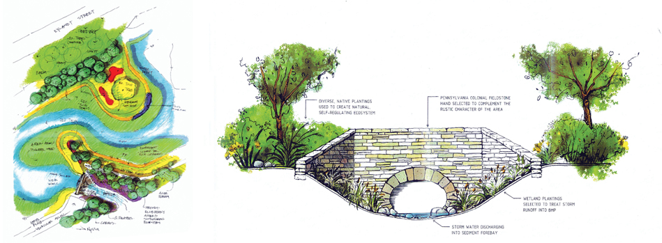
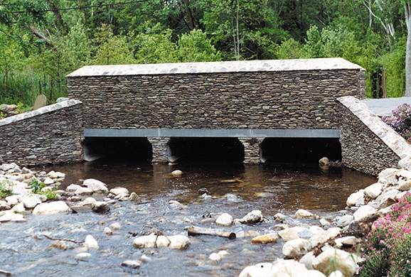
The Staten Island Bluebelt works differently. It’s a system of BMPs on a large scale — about one third of the land area of Staten Island will be served by the Bluebelt system eventually – all municipally owned and operated. In other parts of the country, particularly in the Chesapeake Bay, you’ll find isolated, private landowners with a BMP in place to improve water runoff conditions. You might find, for example, a Kentucky Fried Chicken with a little constructed wetland pond. The Staten Island Bluebelt stands out in a national perspective for its scale: we have plans for about 90 BMPs in South Richmond – of which 50 are built and in operation – and plans for 30 more in the mid-island area.
How do you plan for something on that scale that also has to respond to such specific conditions in each instance?
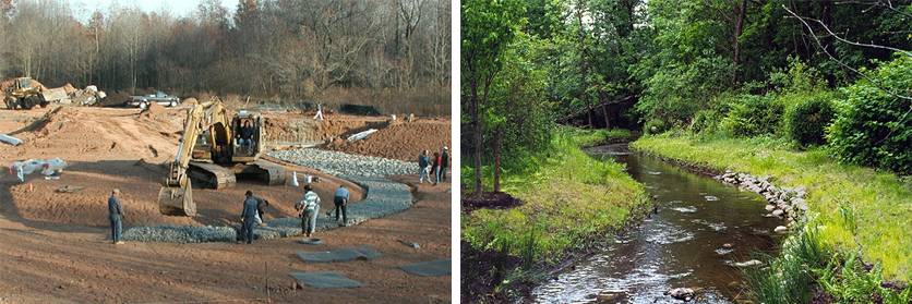
To put it in a few words, we’ve based everything on watershed level planning. A watershed is a geographic area that contributes water to a particular stream or water body. South Richmond has about 15 or 16 watersheds, and for each one the first step is to look at zoning to determine the ultimate development pattern within that watershed. Next, we build a mathematical, hydrological model that will predict what the flows are going to be in the stream system. We then acquire the land around the stream system so that we can maintain the streams as a way to convey the stormwater to the ultimate receiving waters. In a conventional suburban sewer system, when the water gets to the end of the street it is simply dumped into the stream. The cutting-edge aspect of the Bluebelt is that at each and every storm sewer discharge point, at each point where the gray infrastructure transitions into green infrastructure, we have these special facilities — the BMPs — that address the issues of urban stormwater discharge in wetland conditions. Sometimes it’s as simple as a series of sumps — or holes in the ground — that slow the storm water down and allow for sediments to settle, accumulate and eventually get removed by our maintenance forces. Once contaminants have flowed into the natural receiving water body, you can never get them out. Within each watershed, the best site for BMPs is a disturbed wetland – an area that has been filled or paved or otherwise messed up, but yet remains low lying ground. In the last 20 years we have learned a lot about how to construct a wetland, how to get the plant material right, etc. Wetland scientists tell me that wetland plants are unique: while submerged, they are pumping oxygen down into the root mass creating aerobic conditions in what would typically only be anaerobic. Aerobic conditions in the root zone support the bacteria that can eat up the water’s contaminants. Bacteria are the workforces of our planet, breaking everything down and allowing for cycling of nutrients. Wetlands are considered the planet’s kidneys: they filter out and remove contaminants. Our goal is to re-introduce some of the wetlands disturbed by Staten Island’s development.
It sounds like the program was instituted just in time. If it had gone another 10 years…
That’s right. The wave of development started after the Verrazano was opened in 1964. But some of this story goes back to the boom times of the 1920s. Old farms were sub-divided, streets were laid out on paper and many little lots were sold sight unseen. Many people in Brooklyn and elsewhere were persuaded by the possibility of owning a little piece of New York – but little did they know that in certain cases the lot they bought was in the middle of a swamp. And then, when the Depression hit, people could not pay their property taxes and a huge amount of land went into city ownership. So, that was kind of a basic asset for the Bluebelt.
The point is to cobble together whatever public property we can – parkland, highway rights of way, land owned by the State’s Department of Environmental Conservation. The DEP’s acquisition program targeted the missing links, and in all we have amassed 350 acres. Anybody who says condemnation is easy hasn’t been through it! Reviews, public hearings, contacting owners… Luckily, we haven’t had a lot of controversy because in most cases owners are dying to get rid of this property. A common scenario we hear is: “Grandma bought this property in 1924 and every Thanksgiving we get together and laugh about how ridiculous it was that she bought land in that swamp out there. You want to buy it? Oh, great!”
So none of this would have been possible without city ownership?
Absolutely. In terms of the BMP development, we have to be able to do the construction, land-work and earth-moving on the properties. We need to ensure the conveyance capacity of the stream – that we are not flooding anybody out.
In a lot of other places, you’ll find a big watershed with a lot of political sub-divisions, where trying to get everybody together to make a single, watershed-level plan is very difficult. So, that’s one of our advantages, and why we have been able to go as far as we have. We’re lucky that we have a unified DEP agency that can manage this scale of planning.
Which leads me to wonder, to what extent it is scalable to other parts of the city and the country?
The Bluebelt system fits right in with PlaNYC and the stormwater plan that was done back in 2008-2009 that mentions the Bluebelt as part of the green infrastructure of the city. DEP has projects going in Queens and the Bronx, both of which have pretty sizable BMPs. The basic idea, again, is that you have a conventional sewer system with a pipe that comes down to a certain discharge point where you want to add a BMP. Making a pond BMP works well with sewer projects that are adjacent to parks with surface water features. We can fix up the park and manage the stormwater at the same time. For example, Springfield Lake in southeast Queens has never been emptied since the 1930s, when it was built. There are maybe six inches of water in it; algae blooms in the summer. We are going to dredge the lake, make it a part of the drainage system, and add BMPs at each discharge point to intercept sediments.
And yes, there is applicability elsewhere in the country as well. There are a lot of areas where private builders are trying to create these BMPs. One area, in our experience, that has attracted a lot of interest is field management: How exactly and how often do you clean these things out? What is the best way of measuring the accumulation of sediment? What are the design features that make the maintenance easy to accomplish? Because we have so many BMPs in a very distinct geographical area and a single municipal agency has control over this very large area — like I said, it is possibly the largest municipally owned system of BMPs — the Bluebelt has attracted a lot of interest and continues to set national standards for managing the quality and quantity of stormwater runoff.
.Further reading:
• Gumb, “Staten Island History and Bluebelt Land Acquisitions” in Clear Waters (a publication of the New York Water Environment Association), Winter 2009.
• Garin, Gumb et al., “Bluebelt Beginnings” in Clear Waters (a publication of the New York Water Environment Association), Winter 2009.
• Brauman, Gumb, and Duerkes, “Designing for Wildlife in the Bluebelt” in Clear Waters (a publication of the New York Water Environment Association), Winter 2009.
• Hsu, “Sustainable New York City” (a project of the Design Trust for Public Space and the New York City Office of Environmental Coordination), 2006.
The views expressed here are those of the authors only and do not reflect the position of The Architectural League of New York.
Comments