We are celebrating 15 years — and counting — of stories that are deeply researched and deeply felt, that build a historical record of what the city has been.
We are celebrating 15 years — and counting — of stories that are deeply researched and deeply felt, that build a historical record of what the city has been.
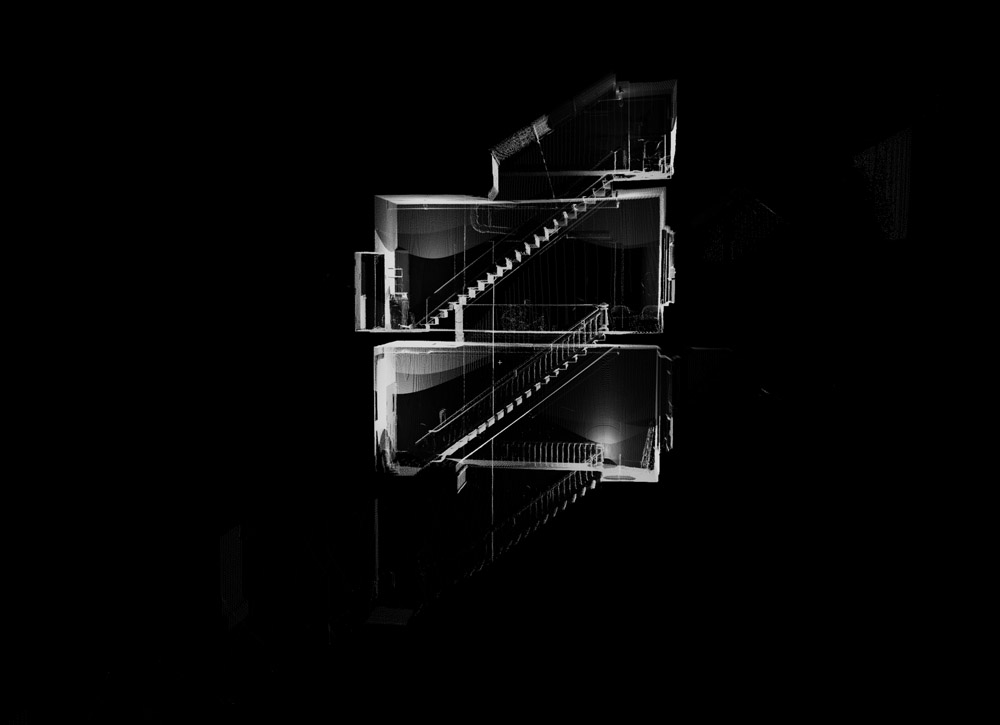
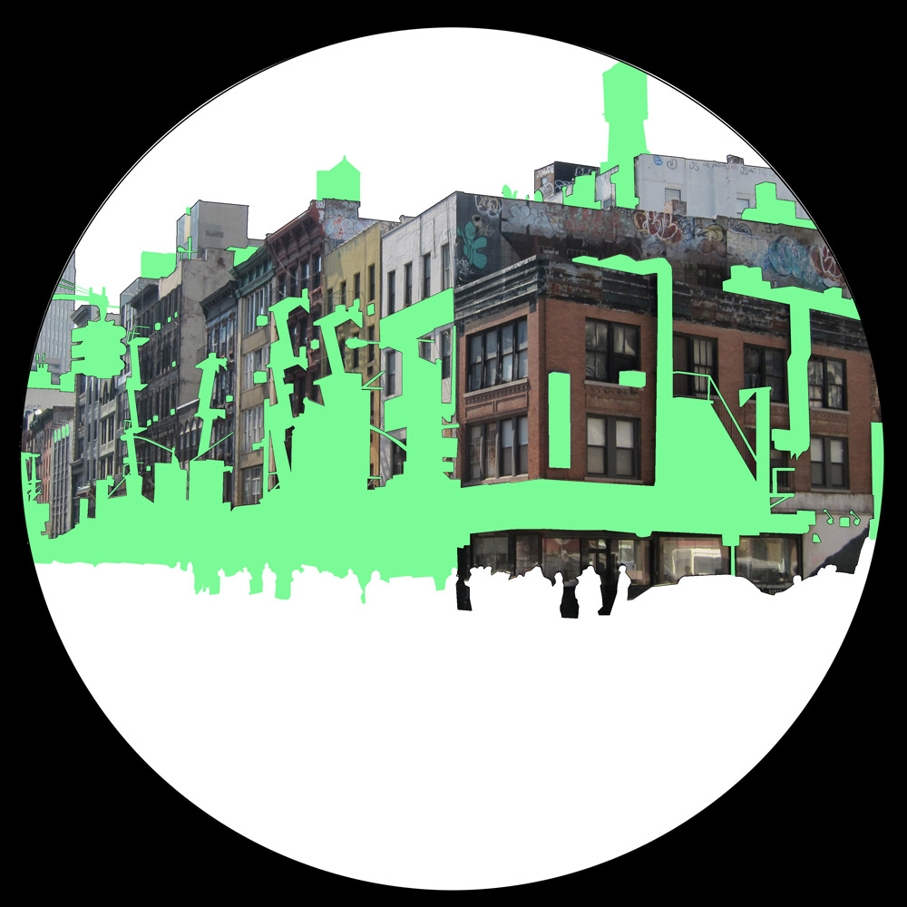
Annie Han and Daniel Mihalyo are Lead Pencil Studio, a creative practice based in Seattle that has blurred the boundaries between architecture and art since its founding in 1997. In site-specific installations that evoke everything from the negative space of a roadside billboard to the interior spaces of dwelling, Lead Pencil Studio’s work interrogates the behavioral and perceptual determinants of space. Sensory perception, and its limitations, play a large role in Looking at Nothing, a recent and ongoing project for which they have examined a variety of public spaces in Rome and New York using LIDAR, which stands for Light Detection and Ranging. This sophisticated laser scanning technology emits millions of laser pulses that measure the distance between the scanner and everything solid before it, from stone walls to chipping paint. But beyond the wow factor of this dazzling technology, Looking at Nothing — and Lead Pencil Studio’s work more generally — reveals a deep sensitivity to those qualities of space that we can’t necessarily see, but nonetheless experience as we move through the city.
Tell us about Lead Pencil Studio and the motivations behind your practice.
Our primary interest is in the unusual conditions found in the city and in ordinary conditions that become unusual when isolated. We are drawn to evocative spatial experiences and while our work may resemble architectural research, our primary output is the creation of spatial conditions in the physical world. Since much of what we do operates in the context of the “art world,” we are free to explore questions not ordinarily permissible in the client services model of traditional architectural practice.
In other words: we get to bend the rules if it suits a project’s trajectory. Of course the art context has its own rules, but since they aren’t the same as architecture’s they have the feeling of being less constricting. Broadly speaking, our interest is in all facets of architecture and art as they relate to the built environment, both rural and urban.
Can you describe the intentions and process behind your Looking at Nothing project?
Looking at Nothing began with a simple observation that led to the question, basically, how do we quantify our spatial experience?
It seemed to us that the shape and proportion of certain spaces have an invisible influence on our experience of — or attraction to — those spaces. We wanted to try to isolate that phenomenon and explore the 3D figure ground urban conditions of a wide variety of public places. We decided that it would be useful to choose case studies in cities prominent in the popular imagination, such as Rome and New York City. To capture the shape of some spaces in these cities, we were going to have to figure out a way of modeling the shapes in enough detail to capture their complexity.
At about the same time, maybe 2005, we started to look into high density laser scanning (a.k.a. LIDAR) and decided that this would be the perfect tool for our independent research. The only problem was that the tool had only recently been invented and the price to own or even rent one was prohibitively expensive.
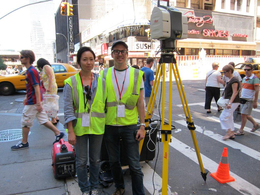
In 2007, we received the Rome Prize from the American Academy in Rome, whose institutional support led us to a generous sponsorship by Leica Italy (Leica Geosystems produces the best machine and software in the industry). In 2010, we had an opportunity to work on the second phase of our work and scan Manhattan for three solid months, thanks this time to Leica US and New York Prize Fellowship at the Van Alen Institute.
How does LIDAR work?
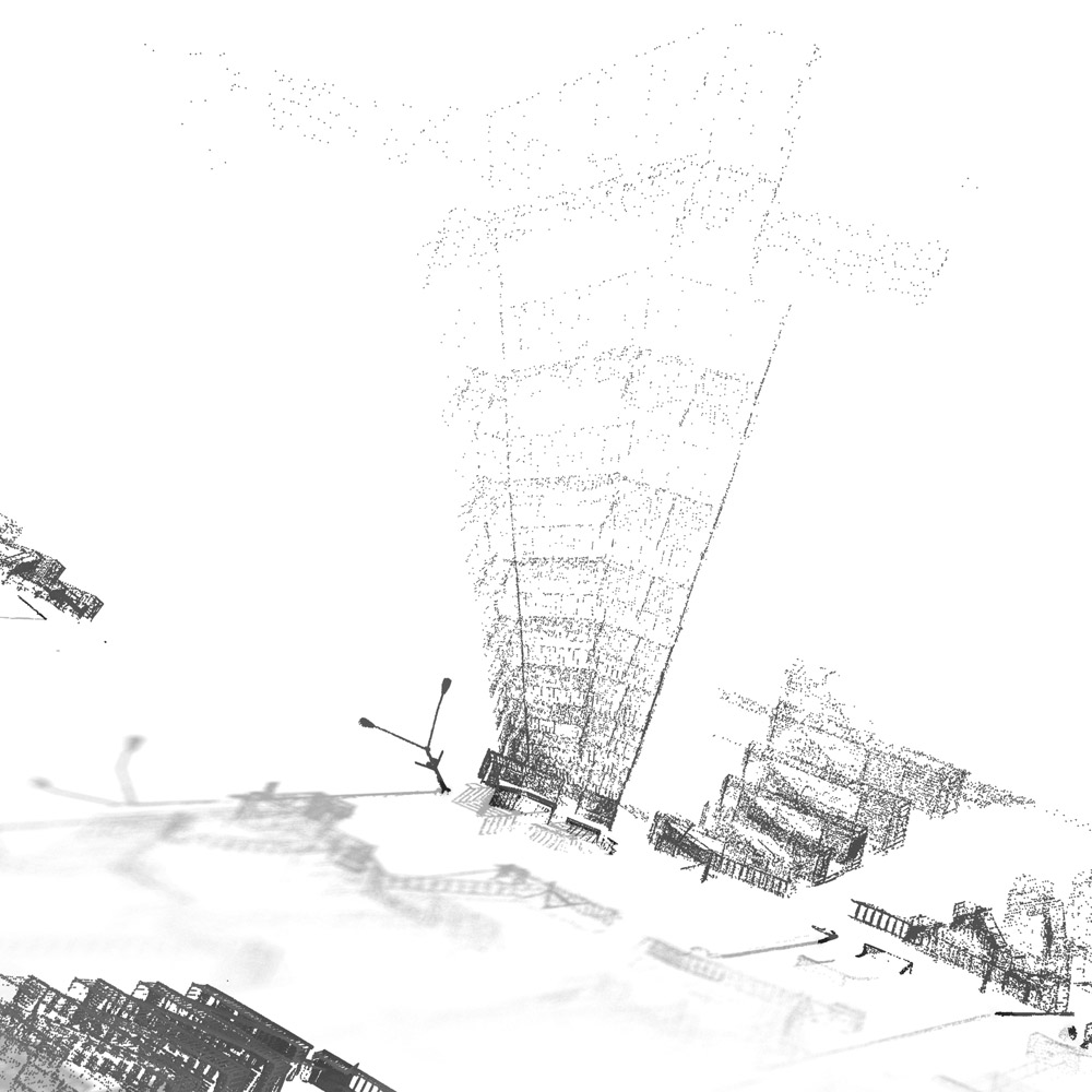
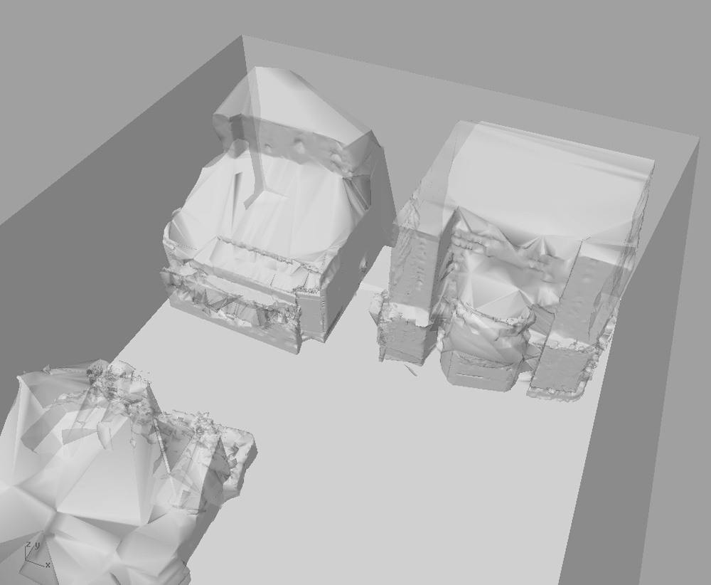
In a nutshell, we use a laser scanner that sends out low-power laser pulses that send back an infrared signal when they hit solid objects, providing highly accurate distance measurements. Location choice is methodical and strategic in order to capture sufficient overlapping data. Later, it’s possible to merge these individual scans to create a measurable digital model of reality composed of millions upon millions of points that are collectively known as a point cloud.
How does LIDAR allow you to see and understand the city differently than, say, photographic documentation would?
As the scan density increases, the resulting image can start to approach the level of detail we’re accustomed to seeing in a photo. Software advances have begun to make high density scanning the ultimate data gathering tool for architecture, archaeology and crime scene forensics.
With this process, nearly any physical component of the world can be generated since the image is a nearly flawless cast of life, warts and all. For example, it is now possible to know what the view or shadow impacts will be from the 23rd floor of a proposed building or the precise slope of a street grade down to millimeter accuracy.
In many ways, this kind of 3D modeling through laser scanning is essentially the evolution of image capture. This isn’t to say that the photographic camera will be made obsolete anytime soon, however. There are parallel efforts underway that attempt to generate three-dimensional models out of multiple overlapping photographs.
How do you personally see the city differently after spending so many hours observing it in this particular way?
The effect of spending so much time with the scanner and compositing scans actually did change our perception of the things we were observing. The ability to walk into a place and in under an hour walk away with a digital model in staggering detail is absolutely amazing. It makes what previously seemed infinitely complex into something more quantifiable. To us, this represents a big advance in the ability to capture spatial conditions accurately.
The city no longer reads like a collection of individual objects, each with its own specific identity. Before LIDAR, we were accustomed to seeing the city as a collection of buildings, and buildings as a collection of materials, and materials as a set of properties. In other words, we were reading the city as a hierarchy of symbols. Looking at LIDAR data helps us to see the city as though it were a single paper-thin surface with varying embossed patterns.
Another simple but important discovery relates to how little we know about what we can’t see. From where I’m standing, I can’t tell you if that brick wall across the street is twelve inches thick or a mile. Before I started working with LIDAR, I was under the impression that I more or less understood the block I live on, my route to work and hundreds of interconnected places throughout the city. After seeing what the scanner sees, we realized that if we operate only in reference to what the eye tells us, our perception of the world is surprisingly limited to surfaces. We assume a brick wall is made of bricks, but we don’t really know what’s behind the first millimeter. For the most part, we have no concrete knowledge of 99.999% of the city.
And everyone’s perception is different: your sensory experience of the city, based on your own first-hand knowledge, may have pushed deeper into some places than mine. Prior to the scanning project, I though we were all in the same place, witnessing it identically. But the differences between the city you perceive and the one I perceive can be significant.
How did you prepare yourselves to examine the invisible, both the interstitial spaces and the ephemeral made visible — traces of movement, the rhythms of the city’s inhabitants?
AH: There isn’t much of an established road map for artists and designers whose primary interest in the built environment concerns its ineffable qualities. Maybe it’s a little odd that we’ve been using a technology whose function is to provide finite quantitative information as a method for exploring the invisible.
Beyond our general interest with negative space, stemming from art history examples like the rock-cut tombs in India, Nolli and Nauman, we have read what we can on the subjects of emptiness, zero and nothing, mostly from poets, Buddhist philosophers and science writers. On the whole, we seem to be following a recurring interest and trying to expand on it from multiple perspectives.
What did Looking at Nothing reveal to you about the shape of public space in Manhattan? What interplays or incongruities did you notice between the intentional built environment (such as buildings, streets, infrastructure) and the temporary or undesigned (like street vendors, curbside garbage, security blockades)?
DM: Spaces that win popularity contests in cities turn out to be defined by some incredibly ordinary structures but have some rather unusual shapes. That was a surprise for us. Also, at least at the urban scale, vendor carts and fences aren’t impacting our spatial perception to the degree that tree canopies and masses of signage do. One surprise in particular came from an analysis we generated in several parts of the city to look at the percentage of “architecture” within an average cone of vision looking down the street. In Manhattan at least, only about 33% of what we see is actually “architecture.” The rest is made up of varying proportions of pavement, vehicles, signs, equipment and sky. This discovery suggests that these elements are contributing to our experience of public space at twice the rate of buildings.
What do you think the potential applications are of this technology for architects, designers and planners? For creative fields more broadly? For the general populace of the city? For mapping and surveying?
The potential seems limitless. It is conceivable that within a few years cell phones will have crude short-distance versions of scanners onboard — similar to Xbox Kinect technology. On the other hand, highly accurate long distance scanners are not likely to get cheap enough for laypersons to gain access to for years to come. For the design community, this technology is fast becoming an essential tool and will begin to eclipse most manually gathered site measurement methods. Professionals who work on adaptive re-use or historic preservation are not yet embracing this technology as fast as they could and therefore risk losing their as-built servicesto the surveying profession. As the software for point cloud processing gets better and the learning curve gets shorter, laser scans will likely become an ordinary part of daily workflow. Some large civic projects now incorporate on-site LIDAR scans to monitor real time construction conditions.
Most surveying companies are transitioning as we speak to laser scanning. But there are still enough occasions that call for measuring a few simple points at long distances, so traditional optic instruments will probably survive another generation. Aerial LIDAR has been in use for almost a decade already and it has become an essential tool for municipal GIS databases.
More and more, new media and CGI students are miles ahead of the design and building professions on understanding the scope of applications for this technology and for point cloud processing.
How do you hope this project will affect or inform the way the public sees or considers the city?
We still have some months of work to complete before we feel like we can publish the portion of the study that spatially compares different public spaces around Manhattan. When this is complete, we expect that it will be of interest primarily to urban planners professionals and maybe architects. That kind of data will be the most practical but it may not end up being the most interesting.
Other art-based projects that come from this scanning work will come into the world through our exhibition channels and they will probably have their own life without any intent to affect or inform anything in particular — which, in an ideal world, is the best use of all for this kind of data.
The views expressed here are those of the authors only and do not reflect the position of The Architectural League of New York.