


Series
Profiles in Public Service
Conversations with public servants illuminate the complex workings of city government and how local agencies shape the physical and lived experience of the city.
We are celebrating 15 years — and counting — of stories that are deeply researched and deeply felt, that build a historical record of what the city has been.
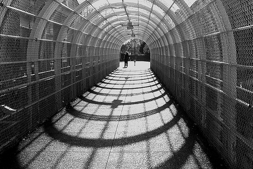
The New York City Department of Transportation has been getting a lot of attention over the past four years, instituting sweeping changes to city roads, from bikes lanes to bus technologies to a car-free Times Square. But some of the most travelled roads in the city – the FDR, the BQE, the West Side Highway, parts of Queens Boulevard — aren’t the City’s at all. New York City’s highways are designed and maintained by the New York State Department of Transportation (NYSDOT). In addition to coordinating all transportation policy for New York State, the agency is responsible for those thoroughfares that we depend on but rarely consider as part of our urban experience (unless we’re stuck in traffic). But NYSDOT’s work extends beyond the road system itself, it regularly leverages State assets and the agency’s own in-house design expertise to create a wide range of landscapes, including a skatepark under the BQE, a waterfront park in Inwood, and an extensive greenway along the Bronx River. Curious to hear about the process and priorities of designing in this singular context, we sat down with Jim Lau, who heads up the Landscape Architecture and Environmental Unit for Region 11, which corresponds to the five boroughs of New York. Read more about the projects Lau’s unit takes on in the interview below.
From the policies of the MTA to the strategies of the Empire State Development Corporation, the State of New York wields considerable influence over the built environment of New York City, presiding over enormous capital projects and embattled public agencies. Therefore, the quiet, local interventions into city life that the State helps brings about – whether it’s a community boat house on the Harlem River or the plantings along a highway in Queens – risk going unnoticed. –C.S.
What does the New York State Department of Transportation (NYSDOT) do?
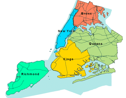
NYSDOT is a State agency responsible for what we call “the built system,” which refers to the highways within the State of New York. The agency has divided the state into 11 administrative regions. Region 11, where I work, refers to the five boroughs of New York City. So we do design work, construction work and maintenance of the structures: the bridges, the highways and, sometimes, adjacent land.
And what is your specific role?
I’m a landscape architect. I’m in charge of the Landscape Architecture and Environmental Unit here. On the environmental side, every project, whether it’s funded by state or federal sources, has to go through various stages of environmental review, such as the National Environmental Protection Act (NEPA) or the State Environmental Quality Review (SEQR). Our department manages that review process. For any project constructed in the state, there are federal or state acts we have to follow. The environmental part of our unit looks at all the levels of analysis required: we look at cultural resources, at hazardous waste, if there are potential impacts to properties with cultural significance to Native Americans; we do air quality analysis, noise analysis, and we analyze potential impacts to wetlands.
On the design side, we design and develop parks, plazas, waterfront areas, streetscapes. When the NYSDOT begins work on a project, our primary concern is the construction and safety of the highways, and the Landscape and Environmental Unit is a small component of these projects. But these days, the need for (landscape architectural) design work within the agency is growing as transportation becomes increasingly intermodal with rising demand and funding for bicycle paths and pedestrian-friendly environments. We’re finding new ways to mitigate the impacts of highway improvements: if you’re expanding or reconstructing a highway, there’s a limited amount of land you can use, so there are often impacts on adjacent properties such as parks or playgrounds. On every project, we try to leave it in better shape than we found it.
About 50% of these design projects take place on State land, and the rest is usually on City land, managed by the Parks Department or another City agency that we will partner with to develop open space projects.
Can you walk me through a couple of your current or recent projects?
Right now we are working on Golconda Park: we are developing a skatepark that is about the size of a football field that runs under the Brooklyn-Queens Expressway at Gold Street between Concord and Nassau Streets. The project is being designed with our in-house design team where we are partnering with Steve Rodriguez of 5Boro on the design of specific skate elements.
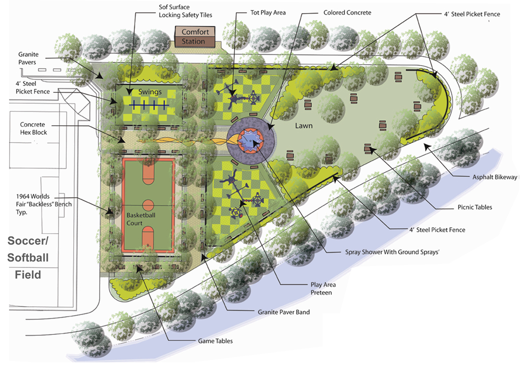
Another recent example is the Bronx River Greenway, which won an award from the NYC Public Design Commission. The project is under construction and almost complete. We worked with the NYC Parks Department on the Greenway’s full mile in length. The components being constructed include boat launching docks, soccer and softball fields, bicycle paths, a boathouse, a picnic area and children’s playgrounds.
For a project like the Bronx River Greenway, how did NYSDOT first become involved?
We first became involved because of our work on the Sheridan Expressway, which runs adjacent to Starlight Park. When we first started looking at the Sheridan, we noticed the lack of amenities; we saw police officers using the ball field and the highway shoulder as parking and realized there was a lot of remediation required. Once we expanded and reconstructed the Sheridan, we took it upon ourselves to redo Starlight Park. And once we started on that, the project expanded as we realized, “There’s more scope here.” We saw the potential to turn it into a full greenway. So additional funding was allocated for bicycle and pedestrian paths. We also purchased land to make sure all the Greenway connections were made.
One project that I think of as a particular gem is Swindler Cove Park, at the end of the Harlem River Drive. This project began because our reconstruction project for the FDR Drive had impacts on wetlands that we needed to mitigate. We had to take out half an acre of wetlands, so we were required to replace a full acre. This 2:1 ratio is based on requirements of the Department of Environmental Conservation and/or the Army Corps of Engineers.
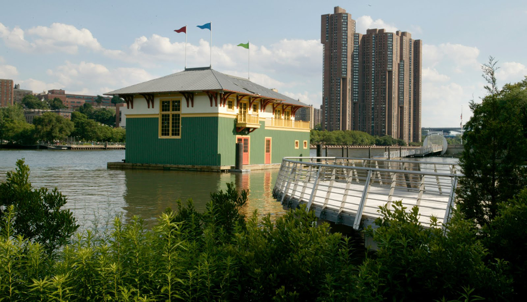
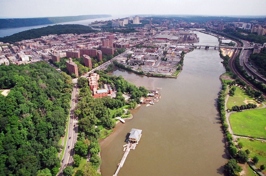
We found an acre up the river a little ways and we started to develop the site. It turns out that the New York Restoration Project (NYRP), the non-profit that Bette Midler established, was already doing some clean-up and improvements in that area. So we partnered with them and, rather than simply replacing an acre of wetlands, we took it upon ourselves to contribute to the site’s design and development. NYRP raised the funds to build a new, floating boathouse. It’s a signature building, designed by Robert A.M. Stern Architects with Armand LeGardeur Architect, in the midst of a park that includes gardens, a freshwater pond, docks, wetlands and a comfort station, designed by our in-house unit with the collaboration of Billie Cohen. When we started this project in 1999, the project benefited from political support from Governor Pataki and other elected officials. And, since then, the partnership and the support and maintenance of NYRP has helped it to flourish. Whenever we are involved in building anything, we require a maintenance agreement to make sure that the project is sustainable, to make sure it lasts. And over the past ten years, Swindler Cove Park has become a really great place.
Of the projects that happen in the city that are under the auspices of State DOT, how many of them would you estimate have a landscape design component?
I’d say almost every one of them at this point. If we’re removing trees, we’re always adding trees. We’re actually working with the Parks Department and the NYRP on their Million Trees program. Since available land for new plantings is in short supply, and since we have additional space for planting – much of which is along the highways, where there is often an additional landscape buffer beyond the right of way, which can be up to 30 feet off the shoulder – we have worked up an agreement under which we would maintain trees planted as part of the Million Trees program.
We want the landscapes that we’re looking at now, whether along a highway or in some other condition, to be as self-sustainable as possible. Instead of spending a lot of fuel and energy mowing lawns or trimming trees, we’d rather plant landscapes that can grow on their own and don’t require a lot of maintenance. So, for that 30 feet of space alongside a highway where you can’t have a tree for safety purposes, we’re looking at ways to have maybe 10 feet of it be the kind of manicured landscape that requires mowing or trimming, and then have the next 20 feet be a “low mow grass,” or a grass that grows to two or three feet, or perhaps plant some shrubs that only grow to a certain height. It becomes almost like an edge condition to a forest. We’re trying to re-establish the forest conditions as much as possible.
Where is that possible in the city?
There’s a wide range. We were working on some of these issues on a project along the Long Island Expressway. The Staten Island Expressway has a lot of green space, and many of the shoulders are wide enough to accomplish this.
What other agencies do you guys interact with the most?
We interact with other agencies in a couple different ways. There’s a pot of federal money that is funneled through NYSDOT to local agencies: the Department of Design and Construction (DDC), the Economic Development Corporation (EDC), the New York City Department of Transportation (NYCDOT), the Parks Department. That money could be for projects ranging from roadway enhancements to earmark funding from politicians to CMAQ (Congestion Mitigation and Air Quality) projects: a federal program that supports surface transportation projects that improve air quality or relieve congestion. Our local Metropolitan Planning Organization decides which projects are funded and NYSDOT reviews them periodically to make sure they’re on track.
On the regulatory side, we deal with the State Department of Environmental Conservation (DEC), the Army Corps of Engineers, and the Coast Guard, if a project is along the water. On the local side, we work with EDC, DDC, Parks, City DOT. And then there’s the MTA and the Port Authority. For example, the Port Authority is working on a reconstruction of the Bayonne Bridge, which links Staten Island and Bayonne, New Jersey, via New York State Route 440. Since 440 is our property, there is always some coordination required, such as requests for permits to work on our land. Working at NYSDOT means you have to know the federal, the state and the local level. Coordination-wise, it’s a great experience.
One might think that NYSDOT is this huge agency that just deals with the highways, but we deal with more than that. As I’ve said, the agency is a funnel for federal funding of local transportation projects. We also have a real estate department. NYSDOT has a lot of subsequent properties allocated to us whether they’re being used for transportation purposes or not. And then every bridge requires some kind of coordination. We’ll be replacing the Kosciuszko Bridge between Brooklyn and Queens. The Tappan Zee is obviously a huge project. Some of these projects will go to what we call “Design/Build,” where the agency is the responsible reviewer and funding source, and design consultants and contractors partner-bid on a Request for Proposals to design and construct the project.
So you regularly work with design firms as consultants?
Yes. We try to do what’s possible in-house. With any agency, determining whether to have a larger public work force or to hire out to consultants is always a dilemma. I feel personally that you need a certain level of in-house expertise as a prerequisite to managing a consultant effectively. Especially at a higher level, in-house work is critical to the ability to understand, to direct and to review what a consultant team is working on.
It’s interesting that your work includes open spaces like parks or plazas as well as landscape features along highways that are not accessible. How do you approach designing for inaccessible spaces?
The experience of those landscape features is more visual. And since we work in an engineering environment, where aesthetics might not always be the top priority, the Landscape and Environmental Unit takes it upon itself to supervise aesthetic choices in roadway improvements, right down to the painting of a bridge or the fascia of a highway. When I first started working here, we did total landscapes. Grand Central Parkway, for example, is totally landscaped. And there’s a history to it. A certain amount of planting had been done already, some by Moses and some by his predecessors. And the aesthetics of the bridges were already in place, whether it’s brick with granite coping or a huge coining of stone or the steel work. The details are important to us.
Landscape architects have a broad spectrum of expertise. For a lot of the landscape architects, the environmental review aspects of the job are a natural fit: they might be plant specialists or stormwater specialists. And so are the aesthetics. Whether it’s picking a form liner for a retaining wall or brick samples, it falls to us.
Speaking of stormwater specialists, stormwater retention and runoff from impermeable surfaces (like highways) are a big issue these days. Do those issues come across your desk a lot?
Of course, best practices in green infrastructure are a big priority. On the Bronx River Greenway, we created a lot of rain gardens, because we had the space to do so. And since a lot of the spaces we have to work with are narrow shoulders, we’ve been developing a lot of bioswales. Obviously, we have a lot of surface water running off our roadways, and a lot of it needs to be regulated. We’ve been getting applications to have cisterns as part of our drainage system to help us to collect stormwater runoff and flush out pollutants before they enter the water body.
Existing runoff points are grandfathered into the system. But as we move forward, any additional water that we’re adding to these waterbodies has to be treated before it goes in. Those requirements and permitting processes are regulated by DEC.
Tell me a little bit about your background as a designer. Have you always worked in the public sector?
I’m a licensed landscape architect. I graduated from Rutgers and I have a Master’s Degree in Urban Design from City College. I worked in the Parks Department for four years, and then I went into the private sector, working in both landscape architecture firms (IQ, William Kuhl) and architecture firms (HOK). When the economy dipped in 1992, this job came about. At that point, landscape architecture within NYSDOT was primarily engaged in “weed and seed” projects. I had a great supervisor in Bob Laravie, a landscape architect who wanted to push the envelope, who wanted NYSDOT to be known as an agency with the ability to put out great design projects. I think, over the past 20 years, we’ve accomplished that.
Working here, I feel very fortunate about the size of the budgets that go into highways. Even if the percentage of that budget that goes towards landscape architectural components is only 5 or 10%, you’re talking about millions of dollars, and that’s how we are able to push the envelope. Design has always been the thrust for me. And Bob Laravie and Sonia Pichardo, my current supervisor, have always encouraged us to design what we really think is the absolute best for a site. Once a well-designed project is built, the public and political backing will follow.
What it takes to keep our highways in good condition isn’t something that a lot of people spend time thinking about. Drivers might not notice or appreciate that paving improvements or pothole removal or a correction to the curvature of a highway’s alignment might cost, say, $20 million dollars. So the additional amenities that my unit brings – plantings, for example, or a new park – can draw attention to these projects, can raise the awareness of politicians and the general public. And that awareness – the opportunity to cut a ribbon, or to have constituents enjoy a new public space – helps fund future projects.
Unless otherwise noted, all images courtesy of NYSDOT.
The views expressed here are those of the authors only and do not reflect the position of The Architectural League of New York.
Conversations with public servants illuminate the complex workings of city government and how local agencies shape the physical and lived experience of the city.
Comments