
We are celebrating 15 years — and counting — of stories that are deeply researched and deeply felt, that build a historical record of what the city has been.
We are celebrating 15 years — and counting — of stories that are deeply researched and deeply felt, that build a historical record of what the city has been.
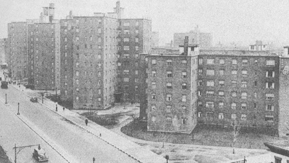
East River Housing Development, 102 St. and First Ave. | Image from the 1943 New York City Market Analysis
WELCOME TO 1940s NEW YORK
In April, to the nerdy joy of historians, researchers, genealogists and the generally curious, the U.S. National Archives made available all data from the 1940 census. On Monday, to help put this trove of information into context, the Center for Urban Research at the CUNY Graduate Center launched Welcome to 1940s New York. The website is based on a 1943 document called the New York City Market Analysis, published by four local newspapers, The New York Times, the News Syndicate Co., Hearst Consolidated Publications and the Daily Mirror, that used the census data to create a portrait of 1940s New York through maps, photos, statistics and narrative. The purpose of the analysis at the time was to help the newspapers target their advertising and thus boost revenue, so color-coded maps not only show a block-by-block comparison of how much people were paying in rent, but also offer statistics about the number of families that owned a radio set, or a telephone. Visit the interactive map here; see an interactive feature from The New York Times that looks at how the city has changed since 1940 in five particular neighborhoods; and read more about the project on the CUR website and on Spatiality, the blog written by CUNY Mapping Service Director Steve Romalewski, who happened upon the 1943 Analysis in a bookstore in 1997 (and who has written about other parts of his mapping work here on the Omnibus in the past).
MIDTOWN IN MOTION: PHASE TWO
This week, the NYC Department of Transportation announced a plan to expand its Midtown in Motion traffic congestion management system. Phase one of the program, which was launched last July, covered 110 square blocks of Midtown Manhattan and included microwave sensors, video cameras and E-ZPass readers that were implemented to measure traffic speeds and allow engineers to monitor and respond to traffic conditions in real time. (For a peek inside the DOT’s Long Island City Traffic Management Center, revisit our 2011 video feature “City of Systems: Traffic Signal.”) The preliminary results show vehicles moving, on average, 10% faster. The expansion will increase the service area to include more than 270 square blocks, and will be fully operational by September 2012. For more information, read the city’s press release on nyc.gov and coverage on The Wall Street Journal’s Metropolis.
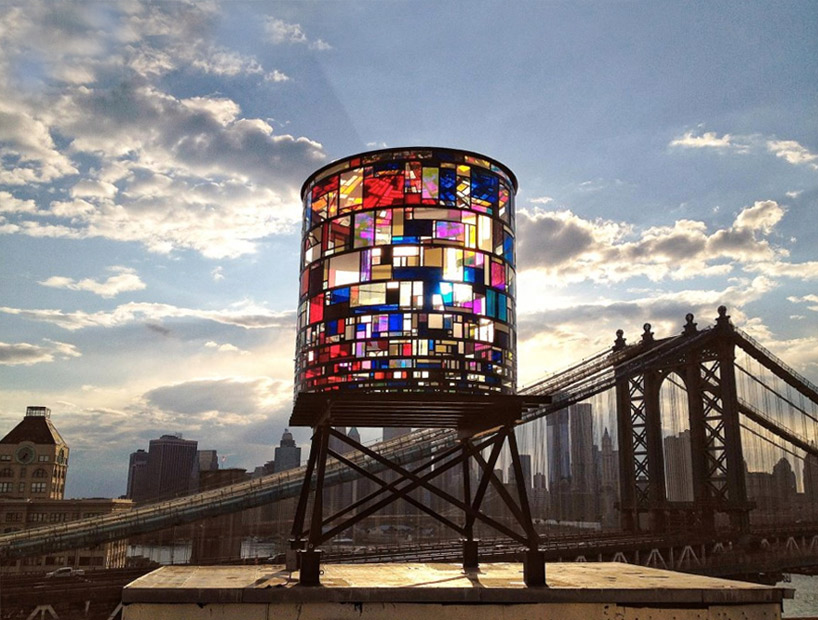
“Watertower” in DUMBO | photo by Robert Banat via designboom.
FANCIFUL WATERTOWER IN DUMBO
The Brooklyn skyline has a colorful new addition next to the Manhattan Bridge. Sculptor Tom Fruin has chosen New York City’s beloved watertowers as the fourth subject of his “Icon” series, in which he uses reclaimed materials to create plexiglass and steel patchwork sculptures that pay tribute to architectural icons around the world. “Watertower” is visible from parts of Lower Manhattan, the FDR Drive and the Manhattan and Brooklyn Bridges, and will be illuminated from within every night by a light show designed by Ryan Holsopple. The one-year installation of “Watertower” will be on view through June 2013.
CALL FOR DESIGNERS: CUP LAUNCHES PAD
Building on their experiences with programs like Making Policy Public (see past Omnibus coverage of MPP here) and Envisioning Development Toolkits, the Center for Urban Pedagogy (CUP) is launching another way for designers and advocates to work together for positive community change. Public Access Design (PAD) will be a series of multimedia projects that “make complex urban issues accessible to the New Yorkers most affected by them.” Offering shorter development times (four to five months from application to completion), the program will allow advocacy groups to see how design can work for them, and will give designers an opportunity to use their skills for the public good. PAD starts off with a call to designers interested in participation — the first of which is open now — followed by a call to advocacy groups with causes that can be helped by better communication through design. Applications from designers are due Friday, June 29 by 5pm. More information about PAD and application instructions are available here.

Bannerman Castle | Photo by Thom Johnson via bannermancastle.org
EVENTS and TO DOs
TOUR BANNERMAN CASTLE
If you’ve ever ridden Metro-North up the Hudson towards Poughkeepsie you may have noticed a tiny, mysterious castle on a tiny island off to your left. On July 22, the Obscura Society (the real world exploration arm of Atlas Obscura) is offering a chance to explore this curious structure with its Excursion to the Abandoned Ruins of Bannerman Island (officially known as Pollepel Island). Bannerman Castle was built between 1901 and 1908 in the Scottish baronial style to serve as a warehouse for Frank Bannerman’s giant and, at the time, growing military surplus business. The Island was eventually sold to the State of New York in 1967 and is currently managed by the New York State Office of Parks, Recreation and Historic Preservation. A fire destroyed much of the structure in 1969, and further damage was done during storms in 2009 and 2010. Though there is an effort to preserve and stabilize what’s left of the castle ruins, there may not be many years left to access this decaying arsenal. Tickets are selling out fast for the tour. Click here for more information about the excursion, and read more about the Castle’s history here, here and here.
FIGMENT
This weekend marks the annual commerce-free, interactive art extravaganza known as Figment held at Governors Island. Bringing art out of the gallery space and into the sun, Figment invites participants to touch, smell, write on, talk to, dance with, play with and learn from the art brought to the island by emerging artists across disciplines. “Interactive art creates a dynamic collaboration between the artist, the audience and their environment.” The event runs from June 9th to 10th, 10am to 6pm. Check out a full schedule for the weekend here. More information and directions available here.
NEW YORK’S LOST SUBWAYS
Next week, Jim O’Grady, transportation reporter at WNYC and contributor to Transportation Nation, will be speaking about New York City’s lost subways at the New York Public Library. In January, he reported on the history of the lost lines and stations, both disused and never used, and guided readers through an online tour of a few locations. In his talk, he will speak about the expansive subway system, the lost subway lines and stations, his own underground explorations, and the creation of an interactive map that overlays the lost system with the existing one. Thursday, June 14, 6:30-8:30 pm at the Mid-Manhattan Library, 455 Fifth Avenue. More information available here.
The Roundup keeps you up to date with topics we’ve featured and other things we think are worth knowing about.
The views expressed here are those of the authors only and do not reflect the position of The Architectural League of New York.