


Series
Studio Reports
Student research and propositions from design studios with real-world implications.
We are celebrating 15 years — and counting — of stories that are deeply researched and deeply felt, that build a historical record of what the city has been.
New York City’s coastal communities and maritime environments are the subject of a lot of renewed attention in the wake of Hurricane Sandy. Practical urban strategy debates of whether to retreat or rebuild do not deal with speculative questions about how the new normal of stronger storms and seasonal inundation might actually suggest new forms of city life. This past semester, in a landscape architecture studio at Harvard’s Graduate School of Design, Chris Reed (working with David Mah, Leire Asensio Villoria, Silvia Benedito, Zaneta Hong, Eduardo Rico, and Enriquetta Llabras) charged his students with exactly this kind of speculation, introducing questions of urbanism and citymaking into the core sequence of studio work for landscape architects. The studio site was Jamaica Bay, an ecologically rich habitat containing many marshy islands, surrounded by highly developed residential and industrial areas including JFK airport, Floyd Bennett Field, and neighborhoods like Marine Park. This varied and vulnerable environment allowed the studio to focus on the development of urban form as driven by productive ecologies and their dynamics — a landscape-based urbanism.
For years, Reed and the innovative design and planning studio that he leads, Stoss Landscape Urbanism, have been at the forefront of advocating and putting into practice the belief that design projects “must be positioned relative to large-scale geographical, ecological, and infrastructural systems, regardless of size,” one of the core philosophies of Landscape Urbanism (listen to more on this topic from Reed in his 2008 Emerging Voices lecture at the Architectural League). In the studio report below, Reed positions the studio assignment — which took on pressing environmental questions around sea level rise and storm surge accommodation and the opportunities inherent to human and urban occupation of richly fluid territories — as a challenge to static or fixed conceptions of master-planning. His introduction is followed by selections from student projects with the students’ own descriptions of how their projects imagined the flexibility of contemporary environmental realities as generators of new kinds of citymaking.– C.S.
Most traditional Western cities are founded on principles of stability and permanence. Change or uncertainty — often in the form of rich and complex landscape systems — are typically erased, filled, leveled, denuded, marginalized, or stabilized.
This studio took a different approach to citymaking — or, in this case, to urban renovation: we assumed change is the norm. In doing so, we built on ecologists’ reconceptualization of their field over the past quarter-century, in which classical Newtonian concerns with stability, certainty, and order have gradually given way to more contemporary understandings of dynamic, systemic change. This reconceptualization brings the related characteristics of adaptability, resilience, and flexibility into sharper focus — principles we should apply not only to ecological systems (whether native or adapted), but also to city systems, infrastructures, and urbanism writ large.
The studio addressed fundamental questions of what it means to be urban, what urbanism is, and how ideas of the city and city life can be informed by and actively engaged with ecological change. In so doing, we moved away from traditions of master planning, which value the comprehensive and fixed vision, in favor of more dynamic and responsive frameworks for small- and large-scale civic change. We also explored multiple development scenarios (assemblies/deployments) over time — rather than a singular and totalizing plan; these scenarios operate according to set of rules or parameters, but can be programmed to respond to a range of differing inputs across time. In this way, our proposals aspire to a level of resilience with regard to long-term environmental, social, political, and economic shifts — and therefore can be rendered truly sustainable, responsive, and adaptable over the long term.
Estuarine Palimpsest: A Process Proposal for Iterative Coastal Urbanization
Team: Anya Domlesky and Justin Jackson; Coordinator and Instructor: Chris Reed
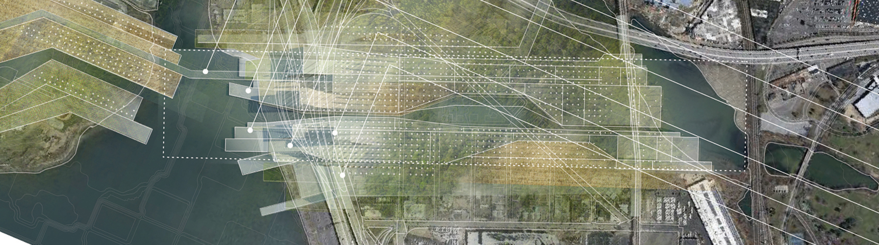
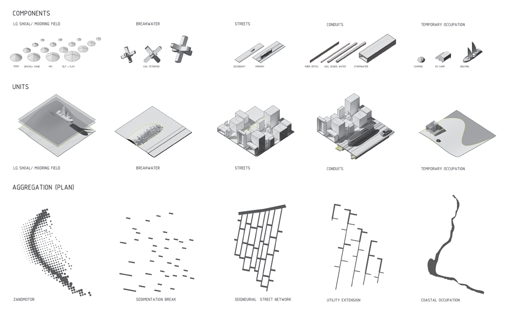
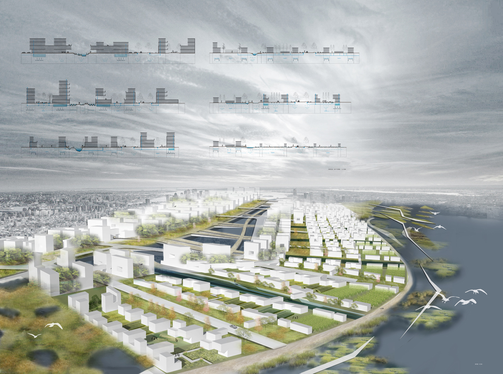
This new prototypical proposal would allow new coastal urban development to adapt to changes in sea level, storm events and other risks; it offers a more nuanced temporal and process-based understanding of urbanism as an alternative to hard engineering solutions and static urban design planning. Like other urban estuaries around the world, Jamaica Bay has been the site of land filling, garbage dumping, massive highway infrastructure, and port development plans. We use this history as fodder to think about the shaping and reshaping of land in the Bay; a process of aggregation, of transport, and of dispersal. At a time when rebuilding after disaster is very much a part of the discussion, we have taken these processes or forces at work in the bay and re-contextualized them for urban processes. Our project proposes not rebuilding in high-risk areas, but migrating in response to events.
We implicitly use the metaphor of the super-organism, a body of people that move, grow, and change over time. With this project, we also attempt to take seriously the challenge of marrying human actions (of urbanization) and non-human processes of weather, coastal action, and distant hydrological changes. A field of dredge piles, breakwaters, and moorings can represent a new set of water-based dynamics and social-environmental ecologies. Therefore, our strategy of citymaking — whereby accretions of building forms can be re-arranged and stacked within long lots that parallel flexible infrastructural corridors/conduits — explicitly responds to sea level changes over time.
Shifting Gradients
Team: Cara Walsh and Andy Wisniewski; Coordinator and Instructor: Chris Reed
This proposal considers the unique condition of Jamaica Bay as an urban estuary, at the interface between the density of New York City and the wild openness of the Atlantic Ocean. Its approach to urbanism acknowledges the radically manipulated, urbanized state of the Bay and the disappearance of the former wetlands that once mediated the transitions between land and sea. Through the overlaying of ecological and infrastructural membranes — ranging from pine barrens to kelp forests, urban reforestation to localized treatment wetlands — a range of newly hybridized conditions form a urban and ecological habitat that allows for both population increase and new wetland habitat within the watershed.
The strategy proposes the cleaning and capping of Dead Horse Bay through bioengineering technologies; landforming through dredge operations to create protective bluffs and buffers for storm surge; creating new coastal forests as public space; and cleaning grey water through a localized wastewater treatment system that simultaneously generates new wetland habitat. Instead of projecting a retreat from a site susceptible to the changing climate, the proposal views the challenge of designing livable, responsible, and ecologically productive urban density as the new reality of the city. It seeks to amplify these conditions within the unique site of Gateway National Park.
Living with Flux
Team: Jing Guo and Meng Jia; Coordinator: Chris Reed; Instructor: David Mah
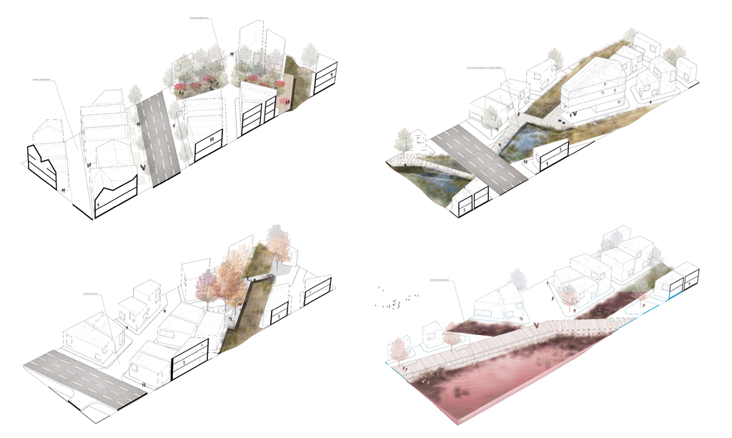
The threat of sea level rise to many coastal communities exacerbates other, long-standing challenges of dealing with urban stormwater runoff and tidal salt water. This design attempts to address this issue, to study how infrastructural systems, ecological circulation, and urban fabric respond to extreme situations. Our proposed landscape framework generates urban form while managing both salt water and fresh water simultaneously.
Our design strategy relies on a hierarchy of water systems with different volumes and salinities to develop corresponding ecosystems, programs, and constructions along with the water system on the site. Instead of building flood walls to block out water, we created a more resilient system that allows residents to live with flux. A soft landform with interweaving paths, based on the current flow of urban stormwater and dredging techniques, functions as an ecological sponge. This sponge manages the two competing water systems at the same time; absorbing, retaining and releasing water, and serving as a filter and buffer between ocean and city. As a result, different ecological processes and programs will happen along the sponge system, responding to the water systems with different salinities and volumes. Once another ecological sponge landform is inserted into the site, the water systems would grow toward each other and gradually form a loop that incubates different programs and activities. The urban fabric would reflect and register the ecological changes as well, meaning the highly diversified building types, densities, and functions represent the new ecological gradient on the site, created by the sponge water system. The design aims to create a dynamic, resilient, and flexible framework rather than a fixed master plan, to let the ecological strategy generate corresponding landscape, infrastructure, and urban fabric.
Float! Nautical Urbanism
Team: Jason Brain and Lauren Hamer; Coordinator: Chris Reed; Instructor: Silvia Benedito
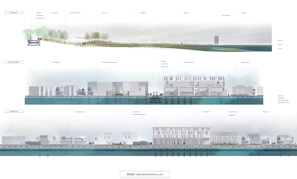
Float! preserves the precarious ecological conditions of an Atlantic saltmarsh while facilitating seasonal inhabitation and recreational activities. By not destroying the saltmarsh or tidal flats with foundations and heavy infrastructure, the buoyant city allows endemic tidal flushing to persist, rehabilitating the environment. Structures within the city are moored according to season and individual leasing, providing a highly flexible ordering of urban fabric that can respond to natural disasters by vacating the site altogether, or simply rearrange itself according to the desires of its residents.
The floating city exists through a hierarchy of buoyancies, ranging from extremely light structures known as “chickees” that accommodate a variety of recreational activities: bird watching, kayak-camping, star watching, etc., all the way to larger mixed-use office buildings. The only grounded infrastructure is a network of wooden boardwalks for marsh walking or hiking throughout the tidal flat. Larger boat-houses provide seasonal or full-time residences, and even the mixed-use office buildings secure to the floating dock armature without a footprint in the salt marsh.
Filter Urbanism
Team: Difei Ma and Miao Yu; Coordinator and Instructor: Chris Reed
The project re-directs dredge operation and economies in greater New York City to build a new, coastal, urban fabric better equipped to deal with fluctuating bay conditions. It also creates a series of water and spatial filters that help to better engage urban dwellers in coastal ecological dynamics.
The project proposes the gradual construction of alternating highlands and lowlands along the coastal edge of the bay. Lowlands are structured by flexible sediment nets that allow for the loose dumping of dredge material, the re-establishment of sediment movement, and the establishment of cleansing wetlands. These wetlands are filled and emptied twice a day, and calibrated to typical fluctuations — emphasizing the dynamic forces of nature. In extreme occasions, like Sandy, the structure will digest a great proportion of the sediment carried by the storm, and filter it out when the stormwaters subside.
Highlands are stabilized fill areas for urban development, within which urban blocks are constructed with terrains that drain stormwater runoff toward accumulation ponds at the high points of the adjacent wetlands. This strategy allows for a new cleansing process and a source of fresh water for the wetlands. The retention ponds also create a linked series of open spaces that connect Marine Park on the north to Floyd Bennett Field on the east. The juxtaposition of highlands and lowlands allow for alternating sequences of urban and ecological spaces — and a more closely engaged set of physical, spatial, hydrologic, and cognitive interactions.
Amphibious Landscapes
Team: Juan J. Reyna Monrreal + Mikaela S. Pearson; Coordinator: Chris Reed: Instructor: Leire Asensio Villoria
The loss of natural habitat throughout Jamaica Bay raises the question of how to deal with urban estuarine conditions. Our project identifies the Marine Park edge as an opportunity to slow surface runoff and storm surge influx into Jamaica Bay and to create a variety of habitats. We accomplish these objectives through a series of modular topographic manipulations and a series of basins that capture combined sewer outfalls, for cleansing and infiltration. As the project approaches the shoreline the module becomes a series of mounds that act as barriers to mitigate tidal energy, and facilitate the establishment and permanence of salt marshes.
The system is organized following a diamond grid structure which allows for localized and sensitive cut and fill operations; forms a modular system that can expand and contract as necessary; generates a series of switchback ramps and pathways for circulation of both water and people; and accommodates and negotiates interactions between ecological, and existing and potential urban development.
Eco[net]
Team: Zhewen Dai and Takuya Iwamura; Coordinator: Chris Reed; Instructor: David Mah
We propose a model of urbanization that will occupy a middle space between the highly urbanized inner city and natural estuary. In our current situation, the city is cut off from nature by a sharp edge, usually a designated 100-year flood line. In this proposal, a green network that functions as open surface drainage and a grey water filtration system for the inner city is implemented one step ahead of urban settlement. This network morphs with descending topography to prioritize drainage and the water cleansing process and, in turn, divides land into developable parcels. In other words, it reverses the city-forming process from street grid-parcelization-landscape to a process that starts from landscape. In this experimental mode, the impact of human activity on nature is more effectively revealed by the growth condition of vegetation on a green network interwoven with the new urban fabric. This framework envisions regulations on discharge and water treatment that strike a balance between development and conservation.
The vegetated drainage corridor and wetland forms, at its intersections, a network that conveys and filters runoff from the city while simultaneously channeling and increasing water-holding capacity during extreme storm surge. We believe this network of green infrastructure will also serve to vitalize the site’s urban condition, weaving together the street life among and between neighborhoods. It provides pleasant views and leisure space that can catalyze retail development. Closely tied up with neighborhoods, the interweaving green corridor also has great potential to be incorporated with community and educational programs and to be flexibly adapted by real estate developers.
Sediment City
Team: Jenny Corlett and Michele Richmond; Coordinator: Chris Reed; Instructor: David Mah
Sediment City uses dredge slurry for berm creation, shore protection, habitat restoration, land generation, and construction fill. Sediment City uses the vast amount of New York & New Jersey Harbor dredge material to raise the elevation of land intended for urban development, in anticipation of the increased frequency and intensity of storms and future sea level rise. To increase the area for future urban development, peninsulas are built out into the bay and an island archipelago is constructed to protect this urban growth. The barrier island archipelago acts as a wave attenuator, deflecting and reducing the energy of everyday and storm surge waves. Of these islands, one-third is reinforced and stationary in order to protect the bay and provide a multitude of habitats. The remaining two-thirds fluctuate, changing shape, size, and material. The reinforced archipelago islands are composed of a mixture of dredged material and soil stabilizers, allowing these islands to break the force of the currents and calm the waters inside the bay. The fluctuating islands are made solely of dredge material and react to larger erosive forces and the influx of new dredge material.
The urban fabric is based on the Brooklyn city block, but the strict linearity of the grid morphs in response to the new peninsula extensions, creating a flexible urban fabric. Building massing is designed to maximize the amount of publicly accessible space. Waterways and inlets puncture the urban fabric to elongate the shoreline. These punctures play a critical role in mitigating storm surge and flooding, as the edges are built to sustain tremendous impacts through various techniques of constructing hard and soft edges. These techniques include reinforced barrier islands (shock absorbers), shoals, riprap, marshes, and forested wetlands for wake dissipation. Sediment City explores ways of productively utilizing dredge material to generate urban regions capable of coping with sea level rise, the increased frequency and intensity of storm surge, and material flux in New York City.
The views expressed here are those of the authors only and do not reflect the position of The Architectural League of New York.
Student research and propositions from design studios with real-world implications.
Comments