We are celebrating 15 years — and counting — of stories that are deeply researched and deeply felt, that build a historical record of what the city has been.
We are celebrating 15 years — and counting — of stories that are deeply researched and deeply felt, that build a historical record of what the city has been.
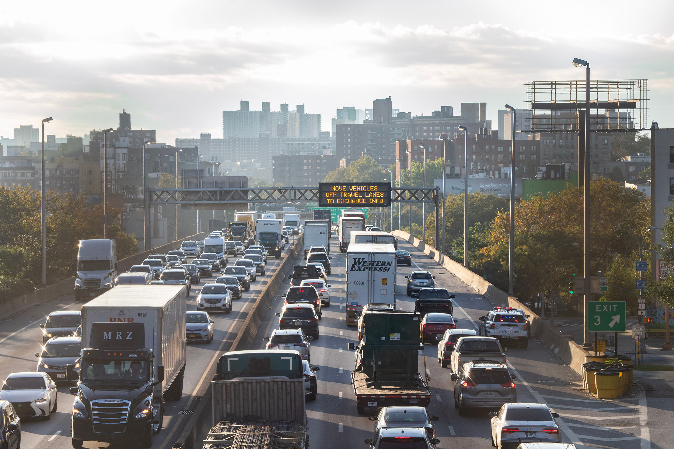
Who built the Cross Bronx Expressway? The infamous road’s best-known origin story is by now a legend. A prototype for US urban interstates and an ur-product of a school of highway planning that cemented inequality, the expressway is the snarling legacy of an evil Robert Moses; Moses, dripping with disdain for the working people of the Bronx, hacked his meat ax through their neighborhoods and sent half the borough into a tailspin. That’s the Robert Caro version, enshrined in his book of outsize influence. But the story is “not so simple,” as Ray Bromley has written, putting the journalistic account in historical perspective and in conversation with the facts on the ground.
On the occasion of our exhibition Cross Bronx/Living Legend, we asked Bromley, a scholar of planning history who has been engaged with the Bronx for decades, to tell a more fulsome story of the torturous highway. How might we understand the choice of its location, or its short- and long-term effects? The story of the Cross Bronx is one that dates back to the rise of regional planning in the 1920s, one profoundly shaped by the influence of the automobile and associated industries and by the federal government’s postwar privileging of homeowners over renters. It’s a story that’s now almost a century old, and that has roles for many protagonists. Blaming Robert Moses lets US society off easy. Instead, to make sense of the “expressway world” and find a path forward, we’ll do better to engage its full complexity and contradictions than seek simple certainties.
In the 1920s, the United States had around 80 percent of the world’s motor vehicles and was the first country to develop substantial middle-class vehicle ownership. New York was already the nation’s largest and most populous city with the most extensive transit system, yet it also experienced rapid growth in motor vehicle numbers and use. Many of the city’s roads were congested and dangerous and vehicles had far more breakdowns and mechanical failures than occur in the 21st century. Simple safety tools like seat belts, head rests, and rounded edges in vehicle interiors were not provided by car and truck manufacturers, and vehicles were not subjected to mandatory inspections to check brakes, lights, signals, and other crucial equipment. Further, no controlled access higher speed routes were available. The result was obvious: growing numbers of serious accidents and rising levels of traffic noise and air pollution in urban neighborhoods.
Despite the hazards, demand for motor vehicle ownership and traffic mobility grew rapidly, trends that were fervently encouraged by vehicle manufacturers and associated producers of steel, tires, oil, gasoline, and other key inputs. Visions of urban growth, suburbanization, and widespread home ownership reigned, with expanding road networks at their center. The US was a world leader in mass marketing of automobiles and in promoting trucks, rather than railway trains, as the predominant means of freight transportation. Many landowners hoped to sell land for highway development and profit from real estate development along the new road axes. In addition, road construction and repair firms, as well as associated industries like cement, asphalt, and petrochemicals, all benefited from building and improving streets and major highways.
As befits a world city growing towards global preeminence, New York adapted to the growth of motor vehicle transportation, developing new neighborhoods — especially in the north and east Bronx and in Queens — and constructing bridges and tunnels across the rivers and inlets that traversed the city. More bridges and tunnels brought more traffic, and that traffic increased the pressure to widen and streamline streets and to develop new arterial highways, parkways, and expressways across the city and onward to neighboring suburban communities.
To the central question considered in this essay — whence the Cross Bronx Expressway? — here is one answer. Though the majority of the construction for the seven-mile expressway took place between 1950 and 1963, its origins date back to this period of rapid growth of motor vehicle transportation. This was the milieu from which emerged the Port of New York Authority and the Regional Plan Association (RPA) and the metropolitan development strategies they advocated and implemented. It was the beginning of a century of transformation of urban landscapes and planning philosophies that reshaped New York, and its roadways, from inside and out.
In 1921, the states of New York and New Jersey established the Port of New York Authority — renamed the Port Authority of New York and New Jersey in 1972 — to support international and interstate commerce in the growing metropolitan area. In short order, the Port Authority launched an ambitious plan for bridge and tunnel construction to link New Jersey to Manhattan and Staten Island, relying on initial advances of funding from the two state governments, and on charging tolls to repay funding and build capital for future projects. An intense debate ensued on whether the principal trans-Hudson bridge should be located entering Manhattan around 57th Street, 125th Street, or 178th Street. The 178th Street option, designed by Othmar Ammann, was selected because it was less expensive and took advantage of rocky outcrops on both sides of the river to facilitate bridge construction.
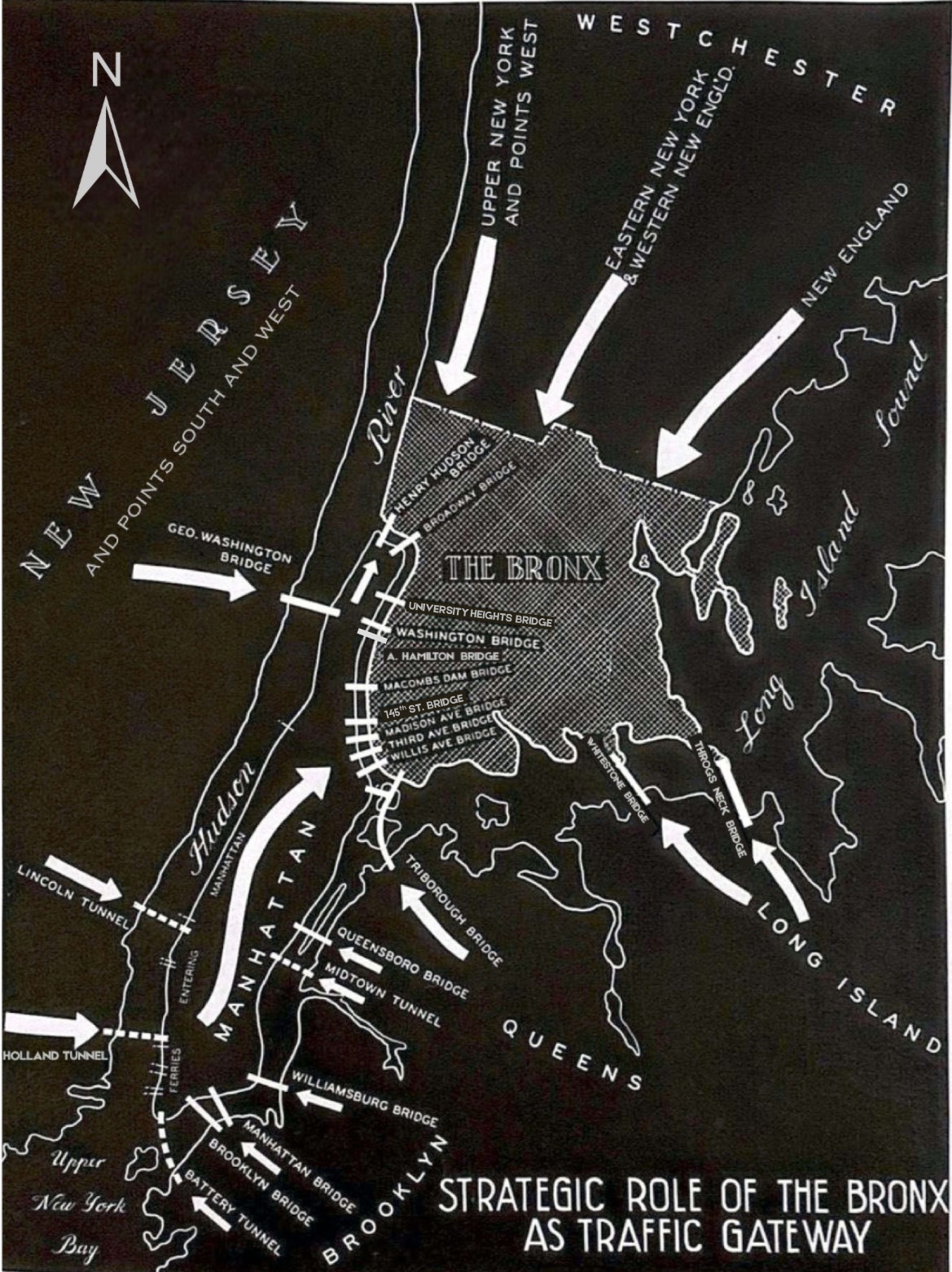
The Charter of the Port Authority guaranteed that its highway bridges and tunnels across the Hudson and between New Jersey and Staten Island would not face competition from bridges and tunnels developed by other entities. This helped ensure the financial viability of all Port Authority bridges and tunnels, and it prevented New York State agencies from bridging the Hudson south of its widest section, known as the Tappan Zee. But as increasing volumes of motor traffic traversed an expanding statewide network of highways and expressways, the result was to funnel most of the vehicles seeking to cross the Hudson within the metro area towards an increasingly oversubscribed conduit.
For extended periods in its history the George Washington Bridge (GWB) has been the world’s busiest motor vehicle bridge, and it points directly at the mid-Bronx. Meanwhile, a similar upward spiral of expansion was underway to the east. Three major bridges were eventually built — the Triborough, the Whitestone, and the Throgs Neck — to convey motorists across Queens, Brooklyn, and Long Island towards the GWB and further west. But all three were opened before major highways were completed to supply them with traffic from both sides. Thus, when the bridges opened, traffic increased very rapidly on local streets, creating serious congestion, noise, and air pollution, and threatening the lives of local cyclists and pedestrians, especially the elderly, the disabled, and children.
Building these bridges and connectors was just a first stage in dramatically increasing the quantity of long-distance road traffic, requiring substantial highway investments to accommodate the growing vehicle flows over the subsequent decades. Each project triggered growth in traffic and road improvements that led to further growth in traffic and more pressure for road improvements. The phenomenon whereby creating motoring opportunities increases traffic, seemingly requiring more and more road investment, is known as “induced demand.” If extra lanes are added, induced demand leads more motorists to make longer journeys, raising traffic volumes and stimulating pressures to add even more lanes, bridges, and tunnels.
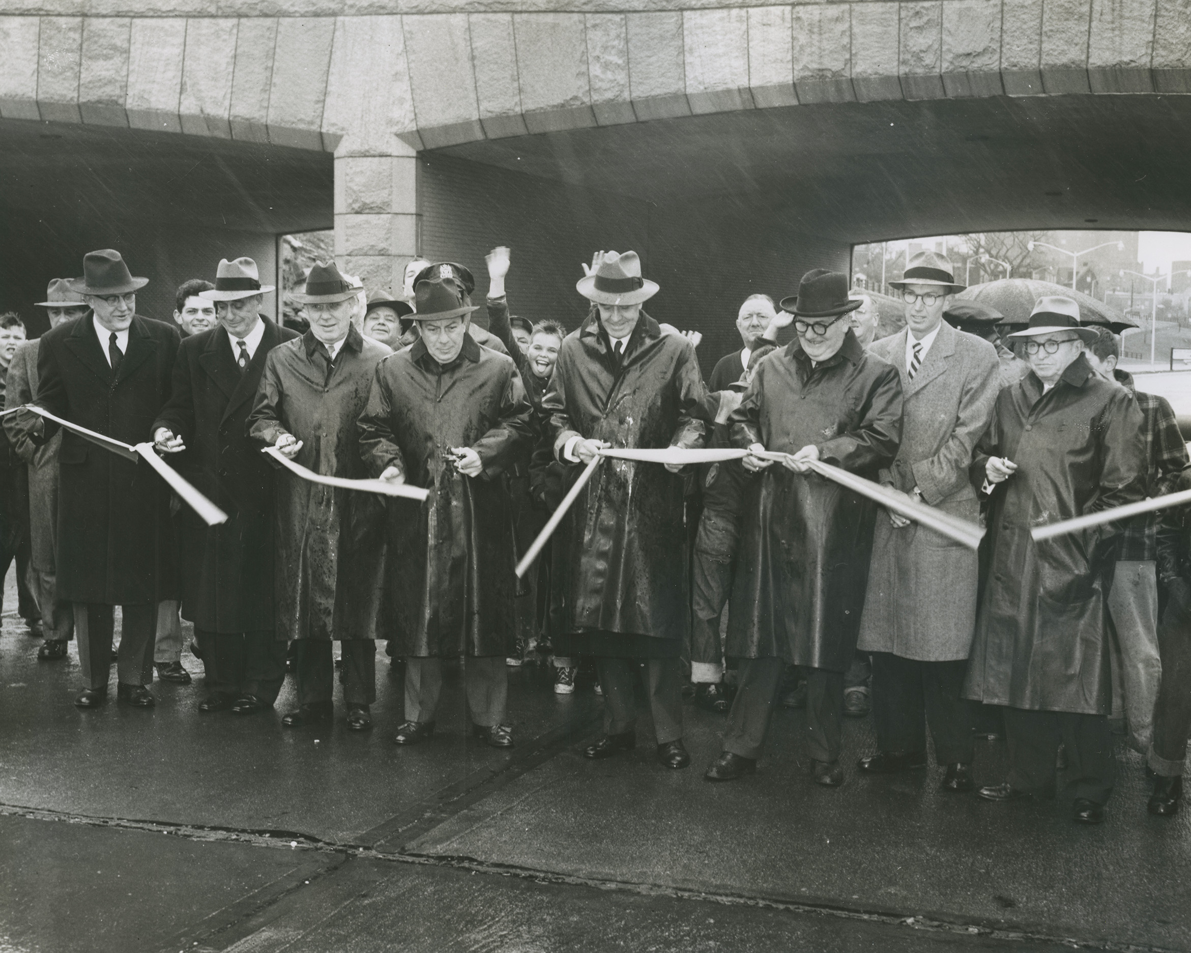
Especially after the lower deck was added to the GWB, bringing its total number of lanes to 14, the existing bridges that linked northern Manhattan with the Bronx were inadequate. To accommodate the growing volumes of traffic crossing the northern part of the city, the eight-lane Alexander Hamilton Bridge carrying Interstate Highway 95 (I-95) across the Harlem River was opened in January 1963, together with the entire seven-mile CBE.
Yet the CBE was not only an organic response to changing conditions and growing traffic demands — it also reflected some of the best planning sense of its day. In many ways, the CBE is a product of the Regional Plan of New York and its Environs published by the RPA in 1929. The plan was prepared over seven years, engaged an international team of experts, and may have had the most generous funding of any metropolitan regional plan ever prepared. Overall, however, it was a proposal from the business and intellectual communities with no formal governmental mandate, and so it was implemented very selectively.
The Regional Plan created a vision of a metropolitan region spreading out and suburbanizing, but also strengthening its urban core, preserving large areas as parks, and maintaining a balance between different transportation modes — roads would be only one part of the whole, in theory. In actuality, the railroad corporations were engaged in cut-throat competition, with several companies likely to be bought up or bankrupted, and neither the Port Authority nor the RPA could mandate cooperation. Air transport did not become a major concern until after World War II. As a result, the focus in the 1930s became bridges and tunnels, and then roads to accommodate the traffic increases that resulted both from longer-distance traffic using those bridges and tunnels, and also from more traffic between neighborhoods in each of the five boroughs of the city.
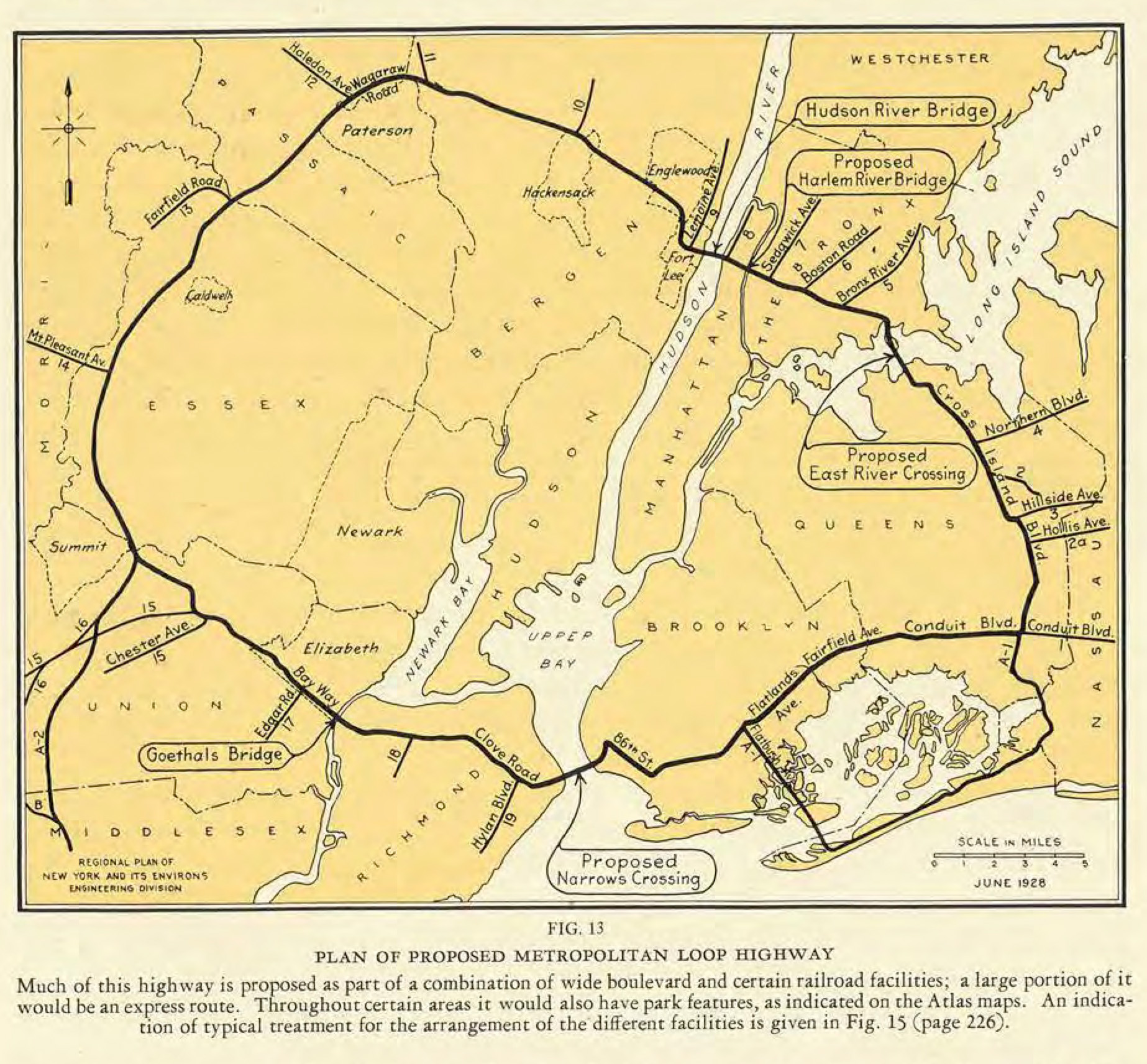
The Regional Plan emphasized the importance of building a circumferential expressway called “The Metropolitan Loop.” It was intended to be the primary highway and freight corridor of the entire metropolitan region, enabling heavy traffic to bypass most of Manhattan and the more densely populated areas of Brooklyn and Queens, and to connect to upstate New York, New England, Long Island, and all points west and south of New York City.
As part of the Loop, the RPA envisaged the CBE would be a great connecting highway, taking advantage of the Bronx’s strategic location as the city’s only mainland borough. The vision of the Bronx as a geopolitically and economically significant “hub” was dominant in Bronx Chamber of Commerce circles between 1935 and 1965: The borough would be a route center for the metropolitan region and the entire northeastern United States. This vision totally ignored the negative aspects of hub status: congestion, traffic noise, air and water pollution, the physical splitting of neighborhoods by rail and highway axes, and demolition of homes to expand highways, parking areas, and highway intersections. Rather, business leaders’ priority was to have as many outside links as possible and to tie them together within the borough, facilitating Bronx prosperity through industry, commerce, warehousing, and vehicle maintenance. Crucial products of this mentality were the opening of the Hunts Point Market in the Bronx in 1962 and the various expansions of the market and associated facilities since then. Other major proposals, none of which were implemented, included a Bronx Airport on the current site of Co-op City, an inter-modal freight terminal and heliport, and a major bus terminal in Mott Haven.
The final route of the CBE was announced in January 1944, following the recommendations of W. Earle Andrews, consultant engineer to the Bronx Borough President. It ran significantly north of the RPA’s proposed route, passing one to two blocks north of Crotona Park through the neighborhoods of East Tremont and West Farms. The routing north of the park and between Webster Avenue and the Bronx River required the demolition of 159 buildings housing about 5,000 people, but it protected the integrity of Crotona Park and East Tremont Avenue, and opened up sites for new apartment construction to the north of the park. Both before and after, Andrews had worked on projects associated with Robert Moses including Jones Beach State Park and the 1939–40 and 1964–65 World’s Fairs, and his recommended CBE route was accepted by Moses, Lyons, and Sheridan.
Given the need to link everywhere south and west of the GWB to both Long Island and New England, the location of the CBE seemed obvious. There were alternatives, but ones that faced great obstacles and could have led to long delays. To implement them, traffic both to New England and Long Island would have had to travel several extra miles; the capacity of the Deegan, part of the Thruway, and the Cross Westchester Expressway would have had to be doubled; and the simplicity of the RPA’s Metropolitan Loop would have been lost. More Westchester homeowner neighborhoods would have been threatened and — given their political power — it is not surprising that these options were never seriously aired for public discussion.
Above and beyond the quest to connect New York City’s boroughs and neighborhoods, and to link to suburbs in northern New Jersey, Long Island, Westchester, and southwestern Connecticut, ever more powerful pressures were emerging at the national level to link cities, metropolitan areas, and regions across the country. In 1956, the launch of the federal Interstate Highway System sought to tie all 48 states in the continental US and all their major cities into a national expressway network. By the end of 1974, over 36,000 miles of the projected 42,500-mile interstate system had been completed and 2,800 more were under construction.
Works of this scale came at a price. The final cost of the entire system, when completed, was estimated to be $90 billion.[1] There was an environmental and social cost, too. Some impacts could be mitigated by following the best practices developed by prior generations of high-speed road planners: The state-led development of parkways in the 1920s and 1930s, followed by the construction of some of the early expressways in the 1940s and early 1950s, provided models for facilitating motor vehicle traffic flows. The new highways limited the number of entry and exit opportunities, banned pedestrians and bicycles, ensured that no businesses faced onto the highways, and eliminated at-grade intersections by building flyovers, underpasses, and cloverleaf intersections. But these measures did not protect against the system’s most widely known impact: displacement. Between 1957 and 1968 at least 330,000 US housing units were demolished for federal highway projects, with the highest levels of disruption occurring in predominantly Black neighborhoods.[2] Thus, the question has another valence: Not only, where did the CBE come from, but also, who is responsible for its legacy? The answer has to do with the distribution of power and authority at the time of the CBE’s construction.
Some early expressways, built between 1940 and 1955, received 50 percent federal funding. But power shifted upward with the 1956 National Interstate and Defense Highways Act, giving primary responsibility for funding, regulation, and systemic planning to the federal government, with only specific planning and construction functions delegated to state and local governments. State governments were required to organize and supervise interstate highway building, focusing on expressways rather than parkways, and largely using construction contractors rather than state workforce. The states paid all construction costs for federally approved routes and then claimed 90 percent reimbursement from the federal government. Local governments were expected to work with the state governments to purchase land and buildings along the routes and to pay compensation to property owners, splitting those costs 50-50 with the state.
This system of intergovernmental relations enabled the federal government to fix construction standards and standardize signage, bridge heights, lane widths, maximum gradients, curvatures, and other measurements throughout the nation, facilitating interstate travel. Putting the power to execute federal plans in the hands of state governments, rather than local governments, worked for most of the country, where local governments were small and had few qualified staff. In the specific case of New York City, however — the largest local government in the nation — expertise was abundant, and the city had a larger population and more civil servants than most states in the US. Nevertheless, oversight of construction was officially in the hands of New York State, even though its Department of Transportation did not have a regional office in New York City until 1970.
Beyond the paradox of a giant city government playing less of a role than many smaller state governments in the building of the Interstate Highway System within its territory, New York was exceptional in other ways that made the federal government’s usual approach an uncomfortable fit. The national legal framework focused on reimbursing owners for expropriated properties, assuming that landlords would duly terminate the contracts of their tenants and, if necessary, ensure evictions took place. For some displaced homeowners, houses were lifted and physically relocated to nearby sites by specialist contractors. Both homeowners and landlords could appeal initial offers of compensation. Whatever the result of those appeals, however, local and state governments could use powers of eminent domain to take properties and force the eviction of their occupants.
In contrast, there was no federal directive to compensate tenants. And more than almost all other cities, New York had a very high percentage of rental housing: over 75 percent of total housing in the 1940s and 1950s. Tenants formed the great majority of those displaced to build new expressways in the city. In addition, of course, New York was one of the most expensive and rapidly growing cities in the country, with very few vacant rental properties. The City established temporary offices to give relocation advice for homeowners and tenants due to be displaced for each major new highway, but many tenants complained that nothing affordable could be found, and that recommended alternatives were smaller, more expensive, badly located, or in much worse condition.
Where did the CBE come from? Who is responsible for its legacy? Arguably, the primary power lay with the federal government because they set design standards and reimbursed 90 percent of the construction costs to the state. State engineers oversaw the construction process. The City was limited to a minor role, sharing responsibility for tenant displacement and financial compensation to real estate owners and homeowners with the State, and making token payments to cover relocation advice, eviction proceedings, and some tenants’ removal expenses. But administrative realities and public perception are rarely perfectly aligned.
With regards to most infrastructure projects, the question “who built it?” is met by a blank stare or a simple response like “engineers and construction workers.” Who built the New Jersey Turnpike, for example — 118 miles of expressway constructed in 27 months from 1949 to 1951? The question is rarely asked, and answers are vague, or simply cite Alfred Driscoll, the governor from 1947 to 1954, because he oversaw the entire state at the time. Typically, the civil servants involved in specific public works are forgotten — not only because so many are involved, but also because professional culture outside the political realm generally favors modesty and anonymity.
Yet Robert Moses’s name comes up almost every time New York’s 20th-century public works are discussed, though he was only one of many public servants and corporate employees who played important roles in selecting, designing, funding, constructing, inspecting, opening, and maintaining those projects. Others with as influential a hand are much less remembered — because they did not make themselves the public face of public works. Austin Tobin, who led the Port Authority for 30 years, rarely gave speeches, hardly ever wrote for publication, and is largely forgotten by the general public even though he may have had just as much impact on the metropolitan region as Moses did.
Moses on the other hand, frequently gave speeches, welcomed interviews for the news media, wrote hundreds of articles and several books about his own career and achievements, and published many highly illustrated booklets about the projects he was associated with. He was interviewed and cited more frequently than any other public figure who had never held elected office, and the work of many thousands was attributed to him with simple statements that “Moses planned” and “Moses built.” In the case of the CBE, Moses urged its construction and played a substantial role in pressing tenants and homeowners to clear out of the way. But most of the power to realize the Expressway resided with the state and federal government.
In April 1945, soon before the end of World War II, the City Planning Commission published a Master Plan for Arterial Highways and Major Streets. Over the following months Moses made many speeches and wrote several articles on the upcoming wave of New York City expressway and parkway construction. One of the key projects was the CBE, and the first CBE construction contracts were signed in 1948. The project would begin with the less densely populated areas between the Bronx River and Schuylerville so as to minimize evictions in the immediate post-war period. Nevertheless, as the project gained momentum from 1949 onwards, a measure of resistance kept pace alongside it.
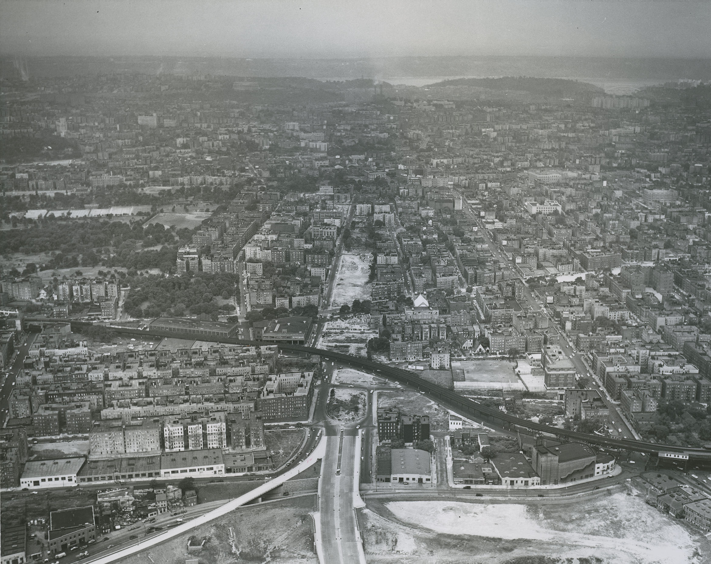
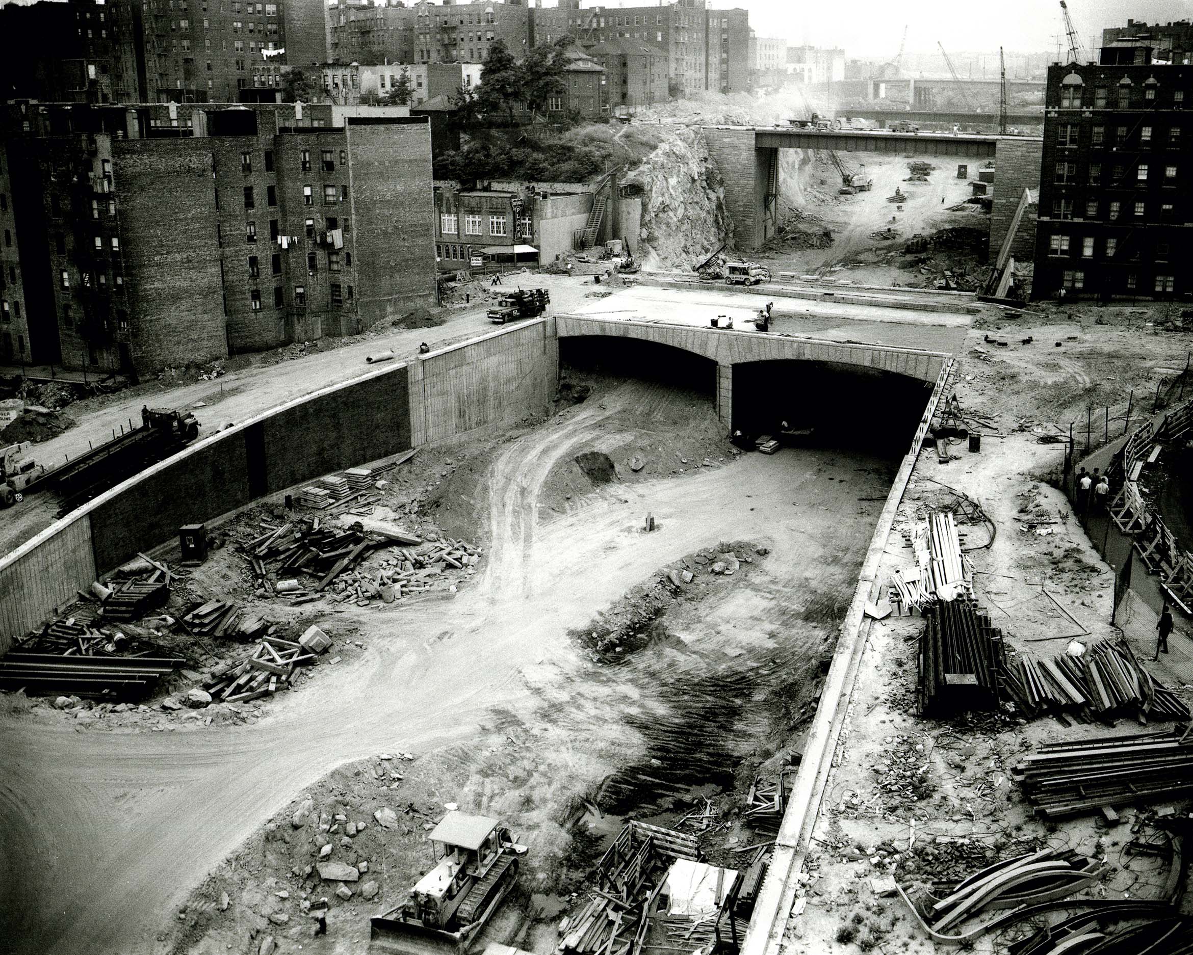
“One Mile” of the CBE located two blocks north of Crotona Park became the most well-known case study in Robert Caro’s The Power Broker (1974), his classic and brilliant biography of Robert Moses. Caro devoted three chapters of his book to the 1952–65 period when tenants were notified of the impending demolitions, and when the neighborhoods along the “One Mile” were severely affected by the noise, dust, dirt, vermin, and social disorganization associated with evictions and demolitions.
Most readers find The Power Broker compelling and convincing, and Caro’s literary style and the sheer volume of sources cited in his notes and bibliography impressive. It is a great book that richly deserves the Pulitzer Prize and many other awards that it has received. Nevertheless, as in all authors’ works, Caro makes some mistakes and is sometimes guilty of repetition and exaggeration, and — as I have detailed elsewhere — he occasionally omits crucial information that might lead the reader to an alternative conclusion.[3]
Caro’s objective in his “One Mile” chapters is clear: to argue that the CBE should have been re-routed along the north side of Crotona Park, dramatically reducing the number and size of buildings that would have to be demolished. He blames Moses for not making this change in 1953 when it was proposed by local residents. Here, Caro’s most crucial omission is the simple fact that the route was announced and publicized in 1944, and that by 1947 it was included in the plans of the city, state, and federal governments and had received substantial additional publicity. Since 1944, several landlords had cut maintenance on their buildings in anticipation of demolition, so the neighborhood was aging and deteriorating.
A Tenant Relocation Bureau for the CBE was formed in February 1946, and the first 55 families were scheduled for relocation later in the year. Tenant households were promised help in finding an alternative home and the equivalent of two months’ rent to help with moving costs. Nevertheless, a Cross Bronx Citizens Protective Association formed in April 1946 to oppose evictions, arguing that all construction should be delayed for several years to allow housing markets and household budgets to recover from wartime austerity. The City persisted, but progress was slow because property and construction costs were rising rapidly in the post-war period and the state and federal governments were not yet ready to make major investments.
Some stretches of the CBE were completed east of the “One Mile” by 1952, focusing on areas requiring fewer displacements. But most tenants in the “One Mile” area did not react or respond to the project until they received eviction notices in December 1952. An energetic local tenant movement emerged to propose an alternative route along the north side of Crotona Park, but technical issues regarding the elevation of the Third Avenue El and the relocation of a municipal bus garage raised substantial problems. With characteristic arrogance, but also deep concern to avoid a rerouting that might impose years of delay and substantial increases in overall cost, Moses insisted on retaining the 1944 route and pushed the project forward. After years of supporting the project, Borough President Lyons briefly switched sides in 1953 and then switched back again. Moses stood firm and the City’s Board of Estimate reaffirmed the original routing in May 1953. Evictions and demolitions were resumed, but most were premature as federal funding was inadequate until 1957 because of delays in passing the Interstate Highways Act. As a result, many apartments were vacant for up to three years before demolition, and neighborhood deterioration intensified.
It would be absurd to belittle or deny the negative impacts on tenant households of eviction for highway construction. However, these impacts were far from unique to New York City — though they were particularly significant in the New York Metropolitan Region in part because it was the largest and most populous metro area in the nation, and because its real estate prices and occupancy rates were high by national standards. Tenant displacement and forced relocation were common throughout the US, and a national solution was needed. Moses was undeniably powerful, but he shared many problems with officials overseeing interstate highway projects in other states, most notably the lack of significant authority and funds to support tenants’ relocation.
Construction of the “One Mile” was completed in 1960 and the entire CBE was opened in 1963. By the early 1960s, the US was entering a period of rising crime and social unrest; the South Bronx, Harlem, and some Brooklyn neighborhoods saw rising rates of arson and abandonment; and New York City as a whole was heading into a severe fiscal crisis, with massive cuts in local investment by the mid-1970s. The East Tremont neighborhood deteriorated like all the other neighborhoods of the South Bronx in the 1960s and 1970s, but, as I have argued elsewhere, it is ahistorical to attribute that deterioration entirely to the construction of the CBE, versus a broader South Bronx and New York City crisis. The neighborhood’s decline was witnessed by many passers-by on the CBE, but it was in actuality less serious than that of several other South Bronx neighborhoods further away.
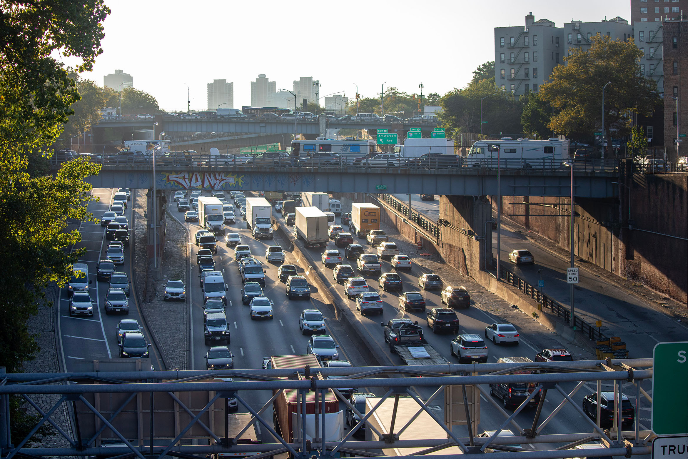
When compared with most other US cities, New York has given less scope to induced demand and maintained a much stronger public transit system. Nevertheless, some of the city’s bridges, tunnels, and urban expressways are notorious for traffic congestion. Over the last 70 years, New York City has shown remarkable restraint: cancelling major highway projects and refusing to widen existing highways beyond three to five lanes in each direction. Its expressways are less than half the width of their widest equivalents in Houston and Dallas, and its expressway network is less comprehensive, with no east-west crossings of Manhattan south of 178th Street or of northern and central Brooklyn. But even restraint cannot keep a continuously expanding national drivership away. And so, facing the swell of motor vehicles, those responsible for the safety and functionality of the city’s streets have made numerous local adjustments to highways, streets, transit, and parking over the last 40 years without fundamentally changing the expressway network as a whole.
The history and current realities of the CBE and other urban expressways on the Metropolitan Loop reflect the priorities of the 1960s. There is little evidence that Moses or other city officials fought for a major commitment to help tenants evicted for public works projects or to improve landscaping so as to reduce noise and pollution. The objective of the interstate highway building era was to complete a massive national highway system according to federal guidelines. State and local governments ignored opportunities to support tenant compensation, highway beautification, and landscaping because they wanted to avoid raising taxes and expanding the public workforce.
Today we have an opportunity to remediate the harms of the past and better mitigate the impact of future public works. Over the last three years two major CBE studies have been completed by consultant firms: first, a feasibility study on how to improve the environment of areas along the CBE between the Harlem River and Schuylerville, focusing on landscaping, congestion relief at key access and exit points, and the possibility of capping some of the sunken sections; second, a “five bridges” repair and replacement study for New York State Department of Transportation, preparing plans for the reconstruction of deteriorating bridges in a one-mile stretch of the CBE running eastward across the Bronx River from Boston Road to Rosedale Avenue. The project includes the possible construction of a temporary bypass highway to carry traffic during the reconstruction period. It is unclear if and when funding will be available to implement recommendations of the first study, but implementation of the recommendations of the second will be prioritized to keep the expressway operational.
New York’s urban expressways are congested and polluted corridors that blight adjacent neighborhoods, and some of their bridges and viaducts are in need of replacement or major reconstruction. It is up to current Bronxites and city authorities to set policies that improve infrastructure, that provide more support for tenants and homeowners in the vicinity of public works, and that achieve health and environmental improvements along highway axes. If the Expressway’s history is one of unforeseen and neglected consequences, its future can be one of intentional planning to enhance landscapes, create jobs, promote public art, mitigate noise, and reduce air, water, and soil pollution.
U.S. Department of Transportation, America’s Highways 1776–1976 (Washington, DC: U.S. Government Printing Office, 1976), 481–85.
Raymond A. Mohl, “Planned Destruction: The Interstates and Central City Housing,” in From Tenements to the Taylor Homes, ed. J. F. Bauman, R. Biles, and K. M. Szylvian (University Park: Pennsylvania State University Press, 2000), 227.
Ray Bromley, “Not So Simple! Caro, Moses, and the Impact of the Cross-Bronx Expressway,” Bronx County Historical Society Journal 35, no. 1 (1998): 4–29.
The views expressed here are those of the authors only and do not reflect the position of The Architectural League of New York.