

![Brooklyn V. 4, Plate No. 64 [Map bounded by Greenpoint Ave., Newtown Creek, Charlick St., Meserole Ave., Kingsland Ave.] | From Insurance Maps of the Brooklyn city of New York Volume Four. Published by the Sanborn Map Company. 1905.](https://urbanomnibus.net/wp-content/uploads/sites/2/2014/10/Newtown-Creek_redone_resize.jpg)


Series
Profiles in Public Service
Conversations with public servants illuminate the complex workings of city government and how local agencies shape the physical and lived experience of the city.
We are celebrating 15 years — and counting — of stories that are deeply researched and deeply felt, that build a historical record of what the city has been.
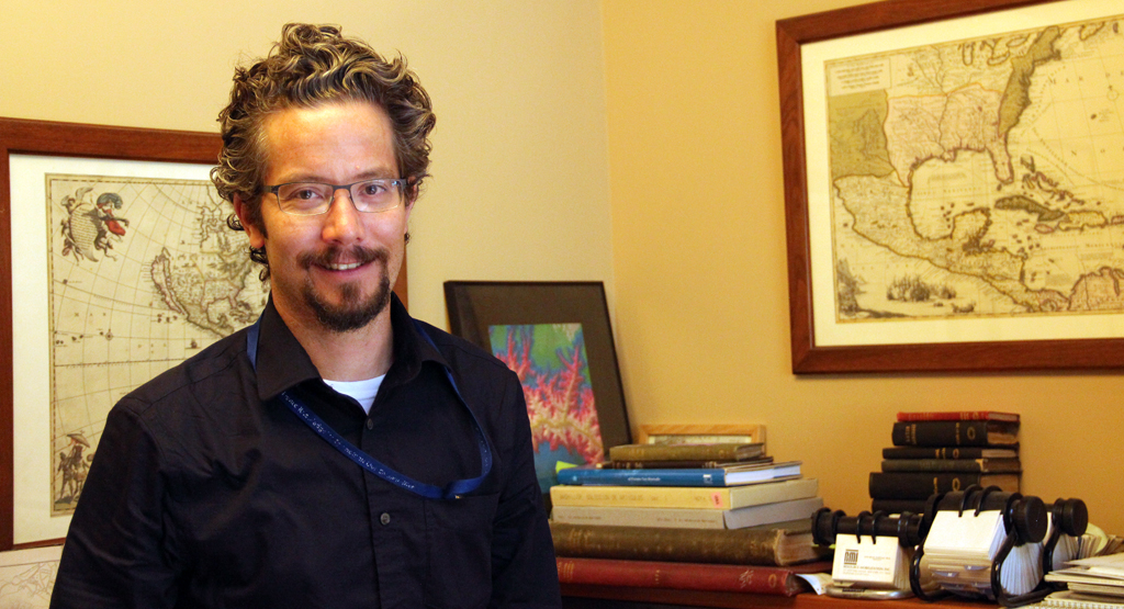
Matt Knutzen performs a different kind of public service than Bruce Barrett of the School Construction Authority or Jeffrey Roth of the Fire Department of New York, two recent installments in our Profiles in Public Service series. He works at the New York Public Library, overseeing NYPL’s incomparable collection of maps, and looking for ways to turn items from the library’s vast catalogue into “actionable spatial data.” In a moment when the convergence of data and digital mapmaking are influencing our understanding of everything from flu trends to the boundaries of college football fandom, it’s easy to forget how maps from earlier eras have informed — and continue to inform — our understanding and planning of the changing city.
17th century land title documents. 18th century maritime navigation guides. 19th century city directories and fire insurance maps. Each has applications to today’s researcher, whether she’s looking up her family genealogy, planning for coastal inundation, advocating for landmark designation, or tracking down companies responsible for toxic waste. In the conversation below, Knutzen explains how his stewardship of New York’s cartographic history is responsive to new digital possibilities and indicative of his unique career trajectory and his infinite curiosity about the visual representation of space, time, and the city. –C.S.
What do you do?
I’m the geospatial librarian and curator of the map collection at the New York Public Library. I oversee the map collection as well as the collection of local history and genealogy. We have a collection of about half a million maps and about 20,000 books and atlases, a large portion of which are maps of New York City that document the built environment at different periods of time.
How did you come to this line of work?
I studied geography and cartography as an undergraduate, and I worked as a commercial cartographer for a number of years after college. Throughout, I was making abstract paintings, and when I came to New York, I was pursuing a Masters in Fine Arts. I felt the need to merge these two divergent tendencies in my work: the controlled, rule-based nature of cartography and the wild expressionism I was exploring in my painting.
I first came to the library to do some research. When I entered the map collection, this jewel box of a space, I literally asked if there were any job openings, and the rest is history. That was 14 years ago.
How do your backgrounds in fine arts and commercial cartography inform your work as a librarian?
I think the artist’s desire to find connections between dissimilar things and to make interesting and unexpected juxtapositions has helped to inform my sensibilities as a librarian. And cartography taught me that disparate bits of information can be layered and aligned spatially. So many different things have a spatial footprint, and there is tremendous power in making spatial relationships manifest visually.
How are the two parts of your title — geospatial librarian and curator of the map collection — distinct, and how do they overlap?
The curatorial component of my work is to act as a steward of the collections: acquiring maps, selecting items for exhibitions or blog posts. The job is to ensure that the collection is around for a long time; that it is described, housed, and displayed to the public effectively; and that it is made usable in new ways.
The geospatial librarian component of my job requires thinking about information spatially throughout the institution, both within and outside the map collection. We are becoming increasingly aware of the extent to which information of all kinds — texts, images, or meta-data that don’t have an obvious longitude and latitude — is implicitly spatial. I work to expose those connections, to make that implicit spatial information explicit.
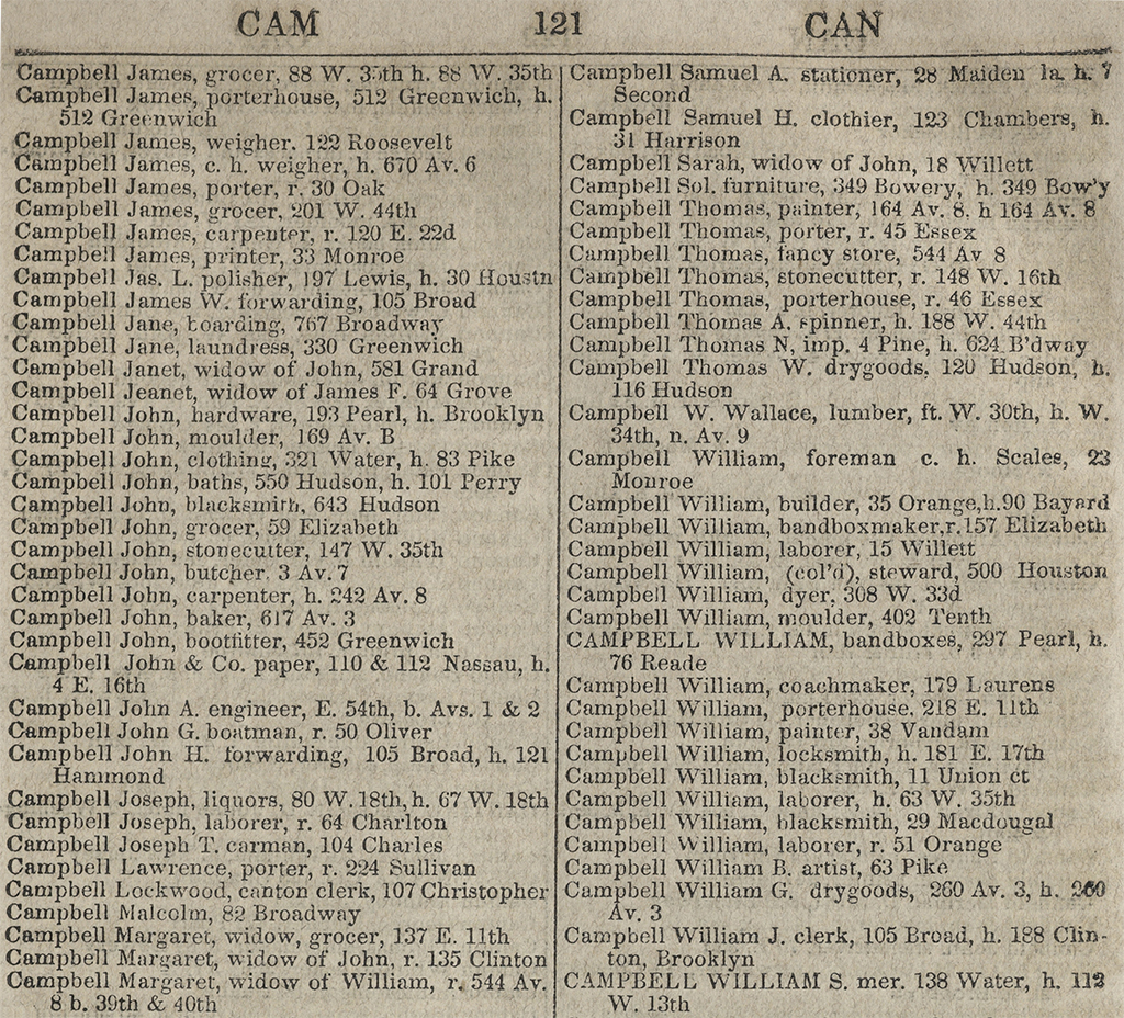
For example, the library has a huge collection of city directories, which we’re angling to digitize in the near future. We’ve scanned a few of them already and developed some pilot projects to parse out the information contained within these directories. In 1854, we have addresses for upwards of 40,000 people doing business in Manhattan. Massaging that information into actionable spatial data means that researchers would be able to analyze different industries in the 19th century and their transformations over time. Before, that kind of investigation would have taken an infinite amount of time and a large budget.
Besides scholars, what other user groups do you serve?
It’s a wide gamut: amateur genealogists, artists, archaeologists, historic preservationists. Recently we had a visit from a curator at the Whitney who was researching Edward Hopper. He wanted to match photographs he had found of some of the buildings Hopper painted to maps of those locations in order to confirm what he knew about Hopper’s process — which was to mix and match buildings and spaces from various places.
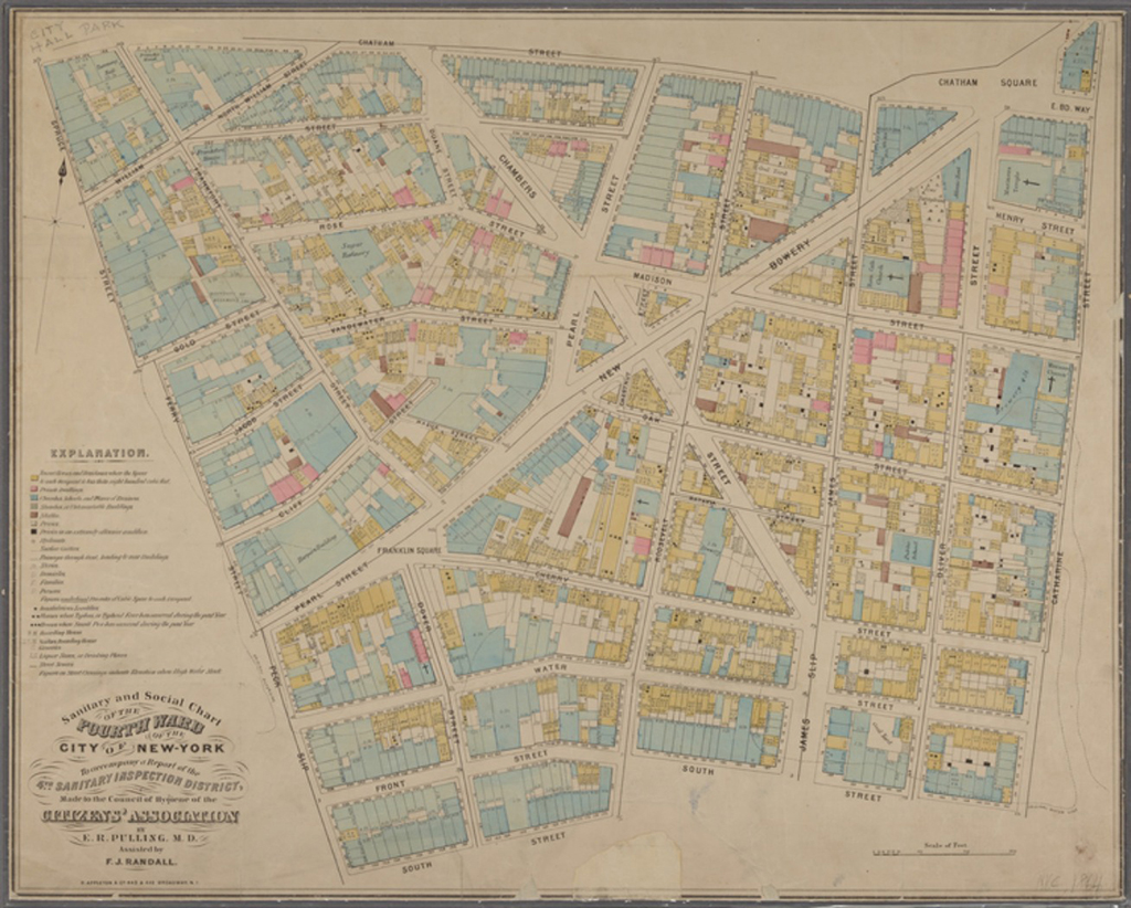
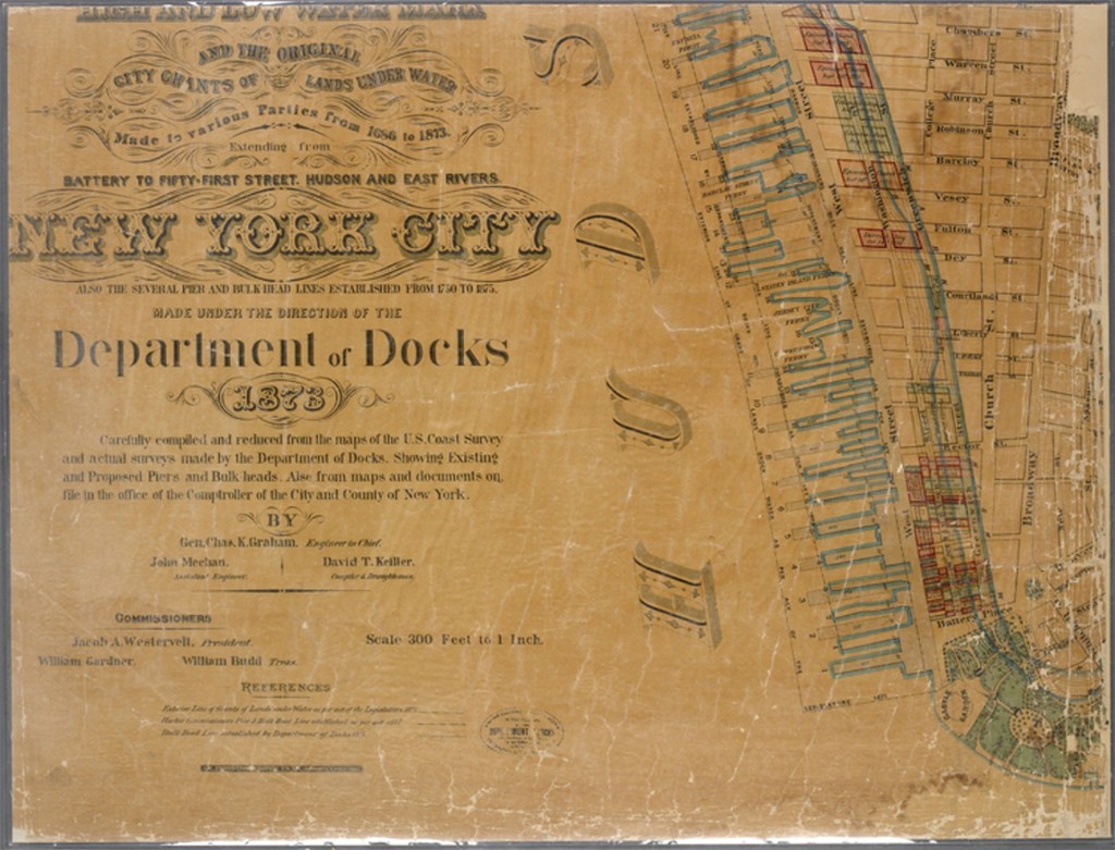
Urban archaeologists will come to find out what was happening in a particular place at a particular time. The Landmarks Preservation Commission uses our maps all the time to research historic sites. Environmental remediation is another huge component of our work. We have two big Superfund sites in New York — Newtown Creek and the Gowanus Canal — and the maps help to reveal the breadcrumb trails back to the original owners, which can help inform how to manage the clean-up process.
What would you say distinguishes the collection at NYPL from other big research map collections? Is there a specific focus?
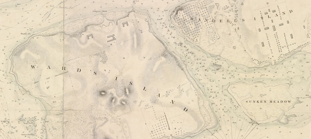
The New York City collection is perhaps the most important collection of its kind, except for maybe the Sanborn Fire Insurance Maps collection at the Library of Congress. There are some important New York City maps that we don’t have and that I covet, some from the Dutch period and a few very interesting maps from the English period. But we have incredible documentation of the transformation of New York City, the massive influx of population over the last couple centuries, in a variety of formats and types of maps. We also increasingly have maps at the building level of detail for the same areas with very little time-distance between them. This gives us almost an animated view of how the structures of the city are changing.
Miraculously, we are still able to collect quite a few maps from the 17th, 18th, and 19th centuries. Recently I came across and purchased a series of colonial survey drawings from New Jersey. The earliest was a 1684 map of Passaic. During land negotiations between European settlers and Native Americans, survey drawings were a legal requirement to codify land tenure and ownership. It’s an amazing collection.
Other acquisitions have to do with filling gaps that exist within the collection. And some new items just come our way. Recently a law firm was moving its offices and came across 17 volumes of Sanborn atlases that we didn’t have.
What are some examples from your collection that might stretch one’s conception of what a map is?
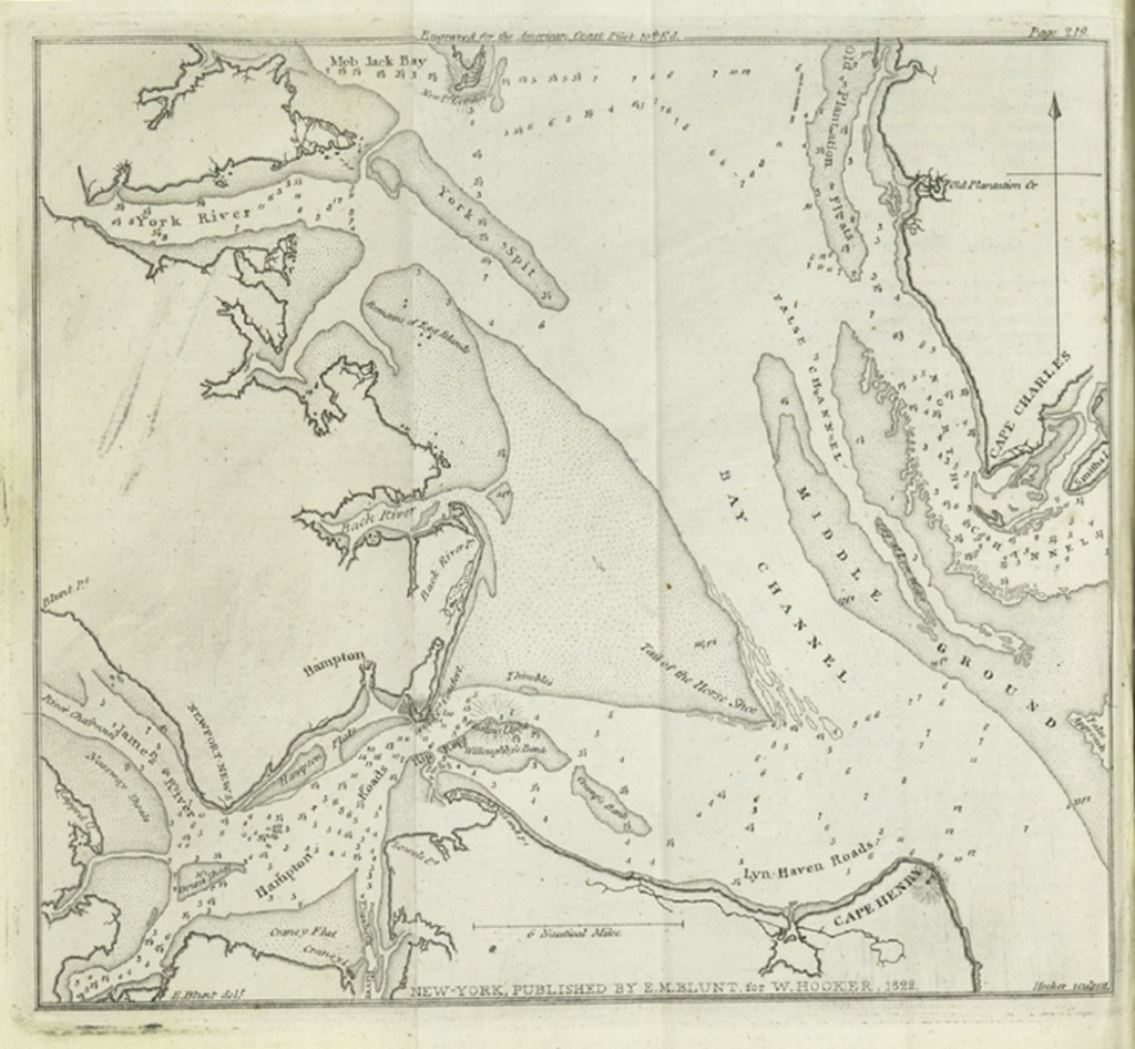
One set of materials that are starting to gel as a broad category is related to traveling. We have a great collection of 17th and 18th century maritime pilot books, highly practical guides to navigate from one place to another. They are wonderful amalgams of different types of information. They have overhead maps of harbors with depth soundings, coastline delineations, rocks and other hazards, as well as landmarks like church steeples and promontories. And alongside those are text descriptions of each reference point. And then a third component are coastal profiles that describe visually which section of the coastline you’re looking at.
And then we have modern versions of comparable types of material. We’ve just scanned a series of early American road guides from the beginning of the automobile era, before we had any federal or interstate highways. To get around you had to make a lot of left and right turns on local roads. These guides are similar to the pilot books: beautifully illustrated, vertically oriented line maps, alongside advertisements for hotels. It’s really rich material, kind of like GPS before there was GPS.
By going through that process three or four times, we are able to build a network of “ground control points,” and then to create a composite version, a warped version of that map, which stretches on to the landscape.
When you zoom into a map like Google Earth, it looks like a patchwork quilt of information: geo-referenced satellite photos and surveys stitched together into one matrix, according to latitude and longitude. The Map Warper tool enables us to get that image into place for our historical maps. Once we’ve done that, we can then harvest or mine that data off of them. Turning a scanned document into a searchable text is a somewhat automated process. Making a scanned map searchable is not automated at all.
How do you decide which maps to digitize first?
Initially, the information that went into the Map Warper was mostly content that we’ve been scanning throughout the years for various different grant projects. In 2010, we received some funding from the National Endowment for the Humanities that enabled us to digitize about 10,000 maps of New York City.
Most of our users come in to do research on New York City. And we chose to digitize maps dated before 1922 because works published before 1923 are copyright free. So we’ve since released all these maps, about 20,000 sheets, to the public domain.
Do you think that current attempts to understand the city through geospatial information could learn from maps from earlier eras?
I always come back to the importance of historical context. We have so much information about what used to be in places we think we know: a ship under the World Trade Center site, buildings from before the Manhattan street grid, the layout of Seneca Village — a community of African-American landowners in the 1830s and ‘40s — in what is now Central Park. The more we can bring this information to light and align it with the common grid of longitude and latitude, all the better for informing policy decisions or redevelopment projects.
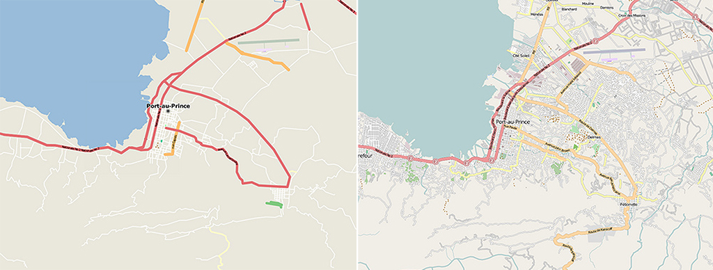
In the aftermath of Hurricane Sandy, officials from the State of New York came to us looking for historical maps of the coastlines of New York. So we put together a series of maps of lower Manhattan, which the New York State Division of Homeland Security and Emergency Services then used to map changes to the coastlines of New York over the course of 400 years. Maps from the colonial British period show a coastline that is almost exactly contiguous with the flood zone. Why did it flood at 10th Street and Avenue D? Well, because that was a salt marsh 200 years ago, and it’s pretty apparent on this old map.
What do you consider to be some interesting new directions in cartographic practice?
For a very long time, we’ve had highly organized, state-run endeavors to map a country’s every square inch, survey every contour in its topography. Increasingly, from the earthquake in Haiti to the Green Revolution in Iran, people are using their own GPS traces to create a usable database. Technology and social media has enabled new directions in collaborative work, which has exploded previous notions of authorship. I think that’s exciting.
And now we have an infrastructure of satellites surveying the world at an even more granular level. But I see this as just another phase of refining the way Eratosthenes measured the circumference of the Earth 2,000 years ago. He established the size of the world, and we’ve been moving toward increasing levels of refinement of that idea ever since. And eventually we’ll reach a point when we start doing that at the microcosmic level too.
I think brain mapping and genome mapping are part of the same spectrum, the same arc. I feel the impulse to add examples of these contemporary directions in mapping to our collection, but the infrastructure isn’t quite there yet. Whether or not we collect the change log of Open Street Map so a scholar in 100 years can see it, I think we have an obligation to maintain snapshots of this data as it develops.
Maps are a device to describe space, but nothing can ever be fully described. As the Zen adage goes, “pointing your finger at the moon is not the moon itself.”
The views expressed here are those of the authors only and do not reflect the position of The Architectural League of New York.
Conversations with public servants illuminate the complex workings of city government and how local agencies shape the physical and lived experience of the city.