We are celebrating 15 years — and counting — of stories that are deeply researched and deeply felt, that build a historical record of what the city has been.
We are celebrating 15 years — and counting — of stories that are deeply researched and deeply felt, that build a historical record of what the city has been.
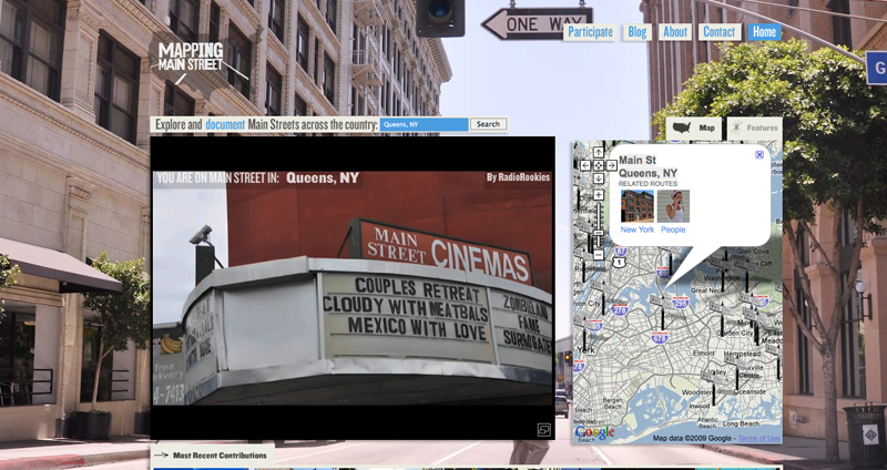
Not too long ago we introduced you to a new project conceived by Omni-collaborator Jesse Shapins and a group of dedicated media artists – namely Kara Oehler, Ann Heppermann and James Burns – called Mapping Main Street. Well, several thousand miles later, the team has built an expansive and flexible online platform for a collaborative documentary media project that will eventually provide a vision of America unlike any we’ve seen before. Users from across the country have contributed photos via Flickr, and audio and video content via Vimeo. The only requirement is that all media “must be recorded on a street named Main.”
Over 400 hundred Main Streets have been documented so far. Which leaves about 10,000 to go. Get involved; each borough of New York has a Main Street. Brooklyn’s got a two-block long stretch in Fulton Ferry. In the Bronx, Main Street is a tiny residential lane near Locust Point and the Throg’s Neck Bridge. In Staten Island, Main Street runs across the southern tip of the island from Tottenville to Conference House Park. Roosevelt Island, weirdly, has a couple different Main Streets. There’s even one on Governors Island. And then there is the fabled subject of this week’s feature: the Main Street that’s the bustling terminus of the 7 train and the central commercial spine of Flushing, Queens.
We recently caught up with Jesse and Kara to talk about the project and where it fits into a constellation of issues including new challenges to political rhetoric, new directions in media production, and new lessons for urban planning and design.
The project was conceived last year in the context of the election. As an image of Main Street was being bandied about by politicians (often as a foil to Wall Street), the team was struck that the reductiveness of such political imagery goes unchallenged and is perpetuated by the media. Main Street is not, in Jesse’s words, “some abstract, general place; there’s a street named Main in almost every city and town across the nation!” So they went about setting up a way for citizens to complicate the presumptions that the image of Main Street, USA provides an accurate shorthand for a certain set of uniform values, economic interests and political opinions. The project’s goal is not to redefine the image of Main Street, but rather “to suggest a critical attitude toward the language and rhetoric around you.”
Mapping Main Street adds another vector to the participatory process that allows for more subjective visions from community members. It just might also suggest a critical attitude toward conventional attempts to identify community priorities around such often contentious issues as growth, change, context, preservation and development. Jesse notes that “since the 1960s, since the rise of advocacy planning and its critique of modernist planning, there has been a strong emphasis on democratic and participatory processes.” But these structures have, for the most part, “emphasized deliberative decision-making, rather than expressions of experience or identity. Mapping Main Street adds another vector to the participatory process that allows for more subjective visions from community members or stakeholders.” And indeed, some communities out there are starting to use collaborative media production to inform policy goals. Case in point: Starksboro, Vermont, where an artist-in-residence assembled a team of students (elementary through college) to use the arts to draw the community into a conversation about the town’s future and support efforts to create a masterplan.
And the production of the media itself has broader applications. Schools, youth programs and local radio stations across the country have been getting in on the action, encouraging participation in the Mapping Main Street project both as a way to build storytelling skills and also to get youth to engage more deeply with place. The four portraits of Flushing’s Main Street below were produced by high school students from the East-West School of International Studies and the Frank Sinatra High School for the Performing Arts as part of WNYC’s Radio Rookies program. Over the next three years, the Mapping Main Street Project will roll out a distributed production model, partnering with a wide variety of NPR affiliates and educational institutions to document every single Main Street in the country. But while infrastructure to support that effort begins to develop, the first phase – producing the participatory platform, setting the tone and getting the word out – will conclude with an exhibition created with Red Antenna (which just happens to be the creative agency that designed and developed uomigrate2.wpengine.com) at the Museum of Contemporary Art in Chicago early next year as a part of the Third Coast Filmless Festival. Just as the website enables thematic relationships between Main Streets to emerge – in addition to the geographic relationships – the exhibit is certain to make manifest the elegance of the Mapping Main Street project: to infuse a cliché with all the contradictions and diversity of America itself.
And that diversity, of course, isn’t just apparent among small towns in different parts of the country. Big cities, like ours, have them too. And sometimes, as in the case of Flushing, Queens, street names harken back to a time when outer borough villages were independent of the growing metropolis that would eventually subsume them. Flushing, in fact, was one of the first Dutch settlements on Long Island way back in 1645. It was the site, according to New York City historian Kenneth Jackson, of the birthplace of religious tolerance by decree in America. These days, the neighborhood is more commonly associated with Queens’ incredible ethnic diversity and large foreign-born population. Flushing’s Chinatown “now rivals [Manhattan’s] Chinatown as a center of Chinese-American business and political might, as well as culture and cuisine” according to the Times’ Kirk Semple. It’s a place of steam buns, old movie theaters, ethnic perceptions and interactions, and some particularly intriguing (and dapper) characters. -C.S.
Mapping Main Street is created by James Burns, Ann Heppermann, Kara Oehler, and Jesse Shapins. Production help from Ian Gray, Josie Holtzman, Sara Pellegrini and Baughman Reinhardt. The project features new original songs by High Places, Chain and the Gang, Jason Cady and The Hive Dwellers. Radio Rookie Short Wave stories in Flushing, Queens are reported by Tracy Leon, Edwin Llanos, Rachel Temkin, Helen Peng, Andrea Torres, Rayon Wright, Alexis Gordon, Hawa Lee and Melissa Best and produced by the Mapping Main Street team with Sanda Htyte and Veralyn Williams. The website was designed by the Mapping Main Street team and Local Projects.
The first phase of the project is produced through the generous funding of Maker’s Quest 2.0, an initiative between the Association of Independents in Radio and the Corporation for Public Broadcasting. The project is also supported with funds from the Berkman Center for Internet and Society at Harvard University and KUOW’s Program Venture Fund. All broadcast radio stories aired on NPR’s Weekend Edition Saturday.
The views expressed here are those of the authors only and do not reflect the position of The Architectural League of New York.