

Series
City of Cycling
A look at how pedal-pushing can redefine urban space. Guest-edited by SLO Architecture.
In This SeriesWe are celebrating 15 years — and counting — of stories that are deeply researched and deeply felt, that build a historical record of what the city has been.
A tangle of highways splits neighborhoods and parks throughout Queens into disjointed fragments impeding safe travel by foot or bicycle. Joby Jacob, a biology professor at LaGuardia Community College, and John Kelly, an IT consultant, are two residents of Eastern Queens working to reclaim the erstwhile Vanderbilt Motor Parkway, using its right-of-way to create a bike network that will reconnect the borough and link it to both Brooklyn and Long Island. We speak to them about the history of the Motor Parkway, the diverse communities it now traverses, current challenges to its rebirth, and the curious alignment between vintage motorcar enthusiasts and greenway bikers.
How did you get involved in this project?
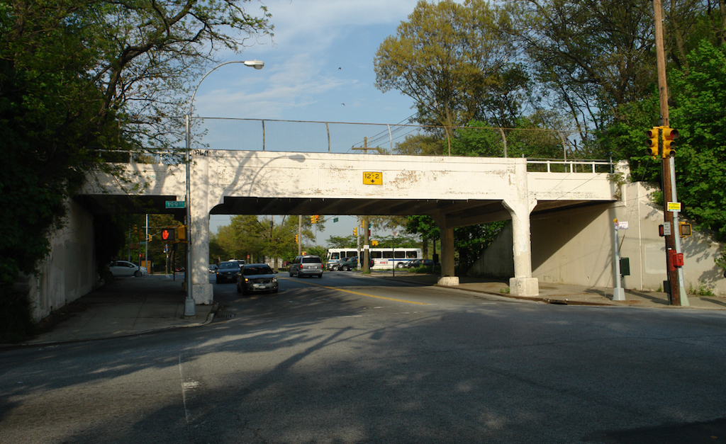
I actually grew up in Fresh Meadows, and my whole life I had been passing under a bridge at 73rd Avenue and never explored it. I moved to a neighborhood where the parkway is at grade and discovered it then. I found out that Nassau County is working on making the trail on their part. And that got me thinking: How do we build an inter-county connectivity? That’s essential because it could be so many things to so many people. It can be for recreational exercise, or for commuters, because it’s an off-street bike path that plugs into the existing New York City greenway and creates one path through all four counties of Long Island.
The parkway plugs into the whole New York City bike network and really makes it possible to get places on a bike. All I could think was, “How come this hasn’t happened yet?” It’s been a matter of meeting with elected officials, building interest, and trying to get city and state agencies to work together.
Tell us a little bit about where the Vanderbilt Motor Parkway is located and how far it stretches.
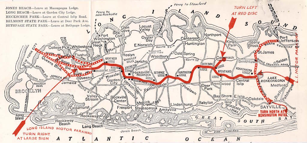
The old Motor Parkway runs from Fresh Meadows in Queens, near John’s old high school, St. Francis Prep, 50 miles east to Lake Ronkonkoma in Suffolk County.
What’s the history of the Parkway?
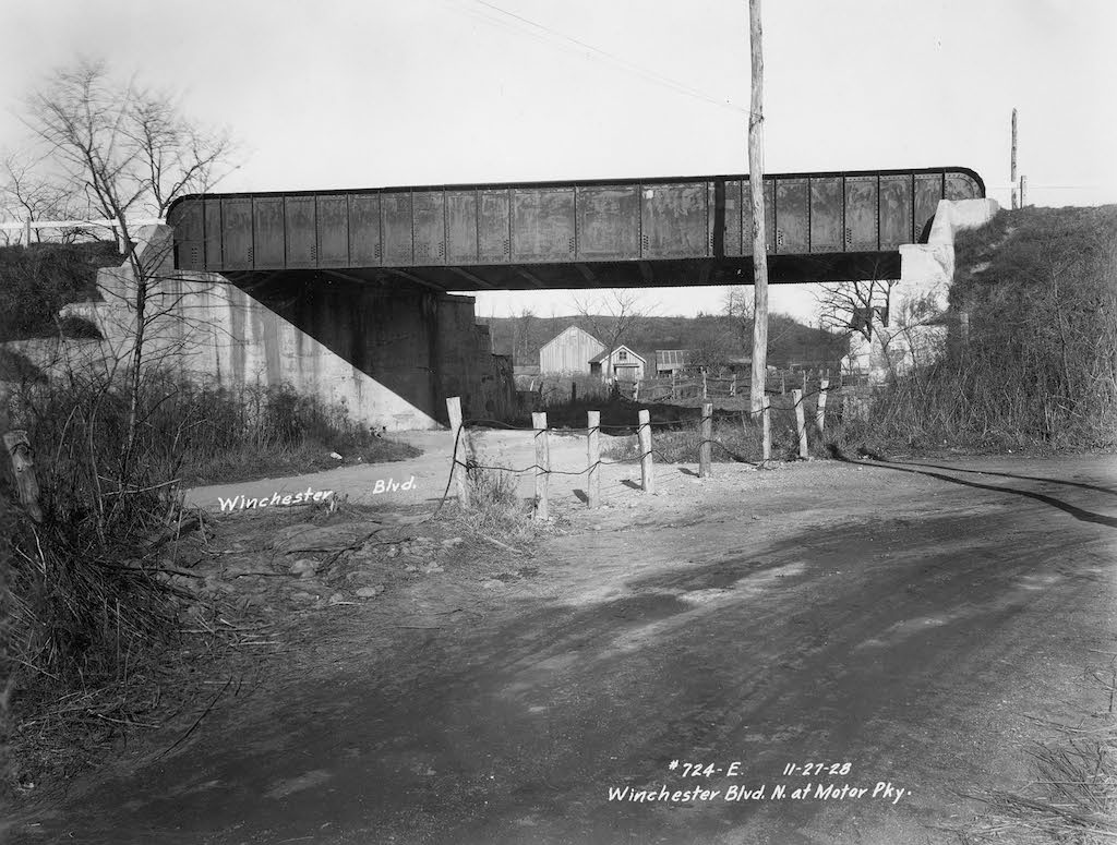
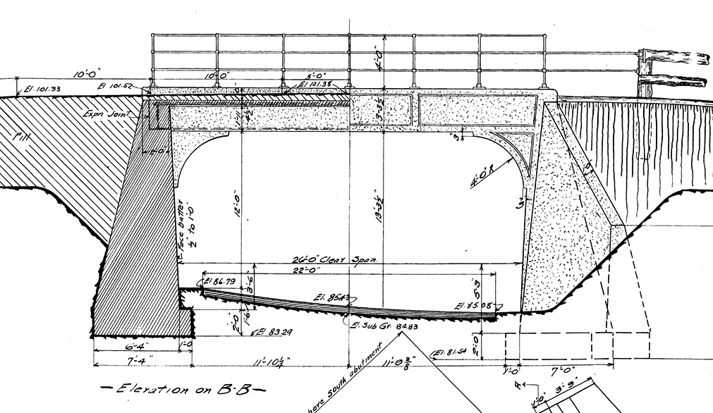
William Vanderbilt II was driving around fast and hitting people crossing streets — that was slowing him down. So he envisioned a Motor Parkway that would be separate from chaotic and slow pedestrians. You had to pay to get on the Motor Parkway. There are still remnants of the tollbooths and guardrails. He created overpass bridges for cars to speed above city streets, with pedestrians and local cars crossing underneath.
Vanderbilt had his main estate on Lake Success, which is right on the Queens border, with his summer house out on Lake Ronkonkoma. The Motor Parkway was also a speedy way to travel between the two homes.
What made the Motor Parkway unique in 1903 is that it was the first grade-separated highway of its kind. What’s happened over the years, though, is that the government basically knocked down a number of the linking bridges. The Fresh Meadows stretch was an extension of the original Motor Parkway, and is still there. The Winchester Boulevard stretch to Vanderbilt’s home is totally gone. Along 74th Avenue, it’s a regular road now. And today’s Vanderbilt Parkway Road is also a regular road these days.
How much of the route do you hope to reclaim?
At the very least, we hope to extend this route to the border with Nassau County. Nassau already has plans for a 14-mile-long greenway from the eastern Queens border through Nassau County to the Suffolk County border, to Lake Ronkonkoma.
For example, we’ve been pushing to reclaim the open space running in front of Creedmoor Psychiatric Center. These rights-of-way are the easier targets to shoot for.
Nassau County wants to make the greenway, but getting the constituent municipalities to want it is the challenge. As just a couple of guys from Queens, we can’t really have a say in that battle, so instead we are putting our focus on getting the Motor Parkway pathway to the Nassau County line — the section where the remaining Motor Parkway infrastructure currently ends — so it’s ready for transformation. Filling in these gaps to the county line will open the imaginations of the folks over in Nassau County. They’ll say, “Hey, if I had a safe way to bike across this county to the start of that Motor Parkway pathway, then I could go even further.”
Is there a vision to thread the Motor Parkway all the way through to the East River waterfront via Long Island City?
We already have the infrastructure for that. We have friends in the Queens Bike Initiative working on making a 20th Avenue bike path happen. Their idea is that you’ll leave Corona Park, cross over, take Ditmars to get over the Rikers Island Bridge and then take 20th Avenue. The other project, the East Queens Greenway, will connect us better to Flushing Meadows Corona Park.
You can pull up a Strava map and one of the interesting things you can see is see lots of bike activity on the Motor Parkway and the Cross Island bikeway, and then you get to Kissena Park and the line stops. It gets cut because the infrastructure that you would be riding on is one of the busiest roads in Queens — Brook Memorial Avenue.
I grew up here North of Kissena Park. I could bike east or west but I never went west because it was too hard to use the roads. But there’s so much there, like the Science Museum. Now we are working on bringing the Motor Parkway west to Flushing Meadow Park.
Is the Motor Parkway set up for local stops? How often do you get on or off?
There are the original exits and on-ramps, which are spaced out at intervals for cars, not bikes. But today they’ve cut in more entrances and exits, given the use, which works. Also, if I had to cross over the Motor Parkway to my neighbor on the other side of it I could still do it. It’s not like the Long Island Expressway, where I would have to reroute three miles out of my way in order to cross over.
The Motor Parkway bridges should have been grandfathered in. Why do you think they were taken away in the first place?
When Vanderbilt built the original Motor Parkway, there was no other competing highway around. At some point the city started to construct free expressways and Vanderbilt had to go out of business because he couldn’t compete as a private enterprise. You just can’t compete against the government.
Robert Moses bullied Vanderbilt, and he said, “I’m going to buy one mile of your road.” Vanderbilt tried to get him to buy the whole thing, but Moses told him, give me one mile, or I’ll run you out of business by matching you exit for exit.
Moses got what he wanted and built the Grand Central Parkway. Vanderbilt, meanwhile, had no revenue and owed back taxes for the land. So he gave the Motor Parkway to the city in lieu of back taxes. Now the interesting thing is that in that meeting the boards of Standards and Appeals — I have that document — it actually says that NYC accepts this as a park from Fresh Meadows to the county line. It is no longer a park.
Parts of the old Motor Parkway have become various rights-of-way: high-voltage power lines, green space, et cetera. We have a protected bike path along part of the Motor Parkway, until the roadway slopes up and the overpass-bridge is gone. The road dead-ends immediately after that.
They could install prefabricated truss bridges in place of the missing ones along the route.
I’m not sure New York City’s Department of Transportation would be interested in building new pedestrian and bike bridges. They require too much maintenance for too little benefit to vehicular traffic. But where there are places that once had bridges, the implicit right-of-way should be treated differently than a place that never had a bridge. The main thing is the lack of belief in the utility of this.
Can you describe what the Motor Parkway looks like?
The other day, we got to the top of Springfield Avenue and there was a mist shrouding the road. It was a picturesque moment because you felt like you weren’t in New York City anymore. We truly felt out of space and time. The grade separation is really different because there isn’t interaction with cars. You can go for a bike ride without thinking about anything. It’s you, nature and your neighbors. It’s the only place in New York City where I actually say hello to strangers.
It’s a nice wide path; it’s wide enough for everyone. You see baby carriages, people going slow, hanging out.
How did the two of you meet to work on this together?
Through Transportation Alternatives, at the Queens Activist meeting. Transportation Alternatives is fantastic, but they are more focused on western Queens. That’s why we are working on this project separately from them, because we are in eastern Queens.
We live and breathe eastern Queens. I work in western Queens but eastern Queens is where I recharge. We grew up here. Some of our community leaders still remember us so we have some cachet. It’s easier to talk to them.
When you discussed the Radschnellweg bike highway in your interview with Ryan Russo, he said that in Europe they have these villages or small cities strung together between longer rural areas and that’s why a highway can work there. Granted in Queens there’s no long stretch of rural space, but Queens is still made up of villages. No one tells you, “Hey I’m from Queens.” I would tell you, “I’m from Fresh Meadows.” Maximum, if I’m generalizing, I’d tell you I’m from Flushing.
I think that an important thing to understand about Queens is that it’s still very much a collection of villages and good bike infrastructure is really about connecting neighbors. It’s not just about getting to work quickly. When I’m on the Motor Parkway, I feel like I understand good bike infrastructure. There are people going fast but also people going for a jog or a ride. It’s just about today.
What are your current challenges?
Joby was able to get a map-post installed on one of these trailheads — the spot where the map would go. Right now it’s a big corkboard to say, “You’re in this community, here’s what you can find here.”
Imagine you were on a highway where there were no exit signs — you just had to know where to get off. How useless is that? It’s a beautiful path but you’re just left wondering and meanwhile you might be less than a mile away from an amazing store.
Where does Howard Kroplick, who collects historical maps and images of the Parkway, fit into your story?
Howard is a pretty cool guy. He’s the town historian of North Hempstead. He’s interested in cars — classic cars. When you’re interested in classic cars on Long Island, you’re interested in the Motor Parkway. He is the president of the Long Island Motor Parkway Preservation Society. He’s had a nice role in the Nassau County part of it.
They’ve worked to restore a small part of the Motor Parkway in Nassau to show people that it can be done.
So there’s a curious alignment here between the vintage motorcar enthusiasts and the greenway bikers.
I’ve actually spoken at the Long Island Motor Parkway Preservation Society, where it’s all people in the hobby. But when I presented my idea, which has nothing to do with cars, I got a full round of applause because I’m trying to preserve the history of Long Island and cars.
It’s almost like a full circle. The picturesque moment of the convertible of the early 1900s is what we think of when we want to ride a bike.
Right — the freedom to get away from everything, and to go far distances.
I got a chance to ride in the Black Beast, one of Howard’s cars. It’s a Vanderbilt Cup winner from the race’s second year in 1909.
Howard brought it to a rally we had, put Joby in it, and rode him around a little bit. And the thing literally has a bike chain to turn the rear wheel!
When you sit in it you get an idea of what driving an early car was like. There’s no seat belt. What’s holding you in is that you’re putting your feet on the floor and pushing your back against the back. Thankfully it didn’t go very fast.
It sounds like our future is rooted in this connection between old motor traffic and new bicycle traffic.
I think that’s really helped us out. Part of our project is really preserving the history of Long Island and Queens. Even if you are not necessarily interested in bicycling, you’re absolutely interested in preserving the history of your local neighborhood.
It’s a line through time and geography.
The views expressed here are those of the authors only and do not reflect the position of The Architectural League of New York.
A look at how pedal-pushing can redefine urban space. Guest-edited by SLO Architecture.
In This Series