We are celebrating 15 years — and counting — of stories that are deeply researched and deeply felt, that build a historical record of what the city has been.
We are celebrating 15 years — and counting — of stories that are deeply researched and deeply felt, that build a historical record of what the city has been.
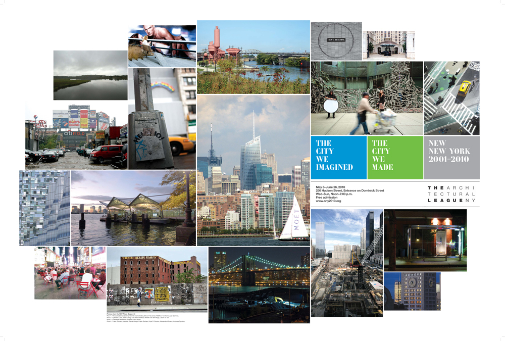
The Architectural League’s latest exhibition, New New York 2001-2010: The City We Imagined / The City We Made, offers audiences a rare opportunity to take stock of the range of design and planning activity that has reshaped New York City over the past ten years. It does so through a chronological display of the past decade’s major projects and proposals, an installation of one thousand photographs of New York today, video interviews with leading New Yorkers, and Archipelago, an original Urban Omnibus video production that explores a day in the life of five New York neighborhoods: Hunts Point, Jamaica, Mariner’s Harbor, Downtown Brooklyn, and Chelsea. While the image of the city –- and the perception of change — often references the urban scale of the skyline, the experience of the city emerges from daily interactions with the built environment at the scale of the neighborhood: the ways the physical city shapes how we live, work, play and move. Watch Archipelago below:
The City We Imagined / The City We Made is the sixth in an ongoing series of Architectural League exhibitions about contemporary architecture in New York City. This installment chronicles the transformation of the physical city in terms of the convergence of an array of powerful forces: the events of 9/11, the policies and priorities of the Bloomberg Administration, the volatility of global and local economies, advances in material and construction technologies, and a new interest among the public in contemporary architecture.
In that light, Archipelago seeks to explore how the physical environment of New York is used and experienced in one neighborhood in each of the five boroughs. Each of these communities has undergone changes both visible and invisible in the past ten years, wrought by development in some cases and disinvestment in others. Each defies preconceptions while attesting to the baffling complexity of the city’s systems, from the world’s largest food distribution facility to the AirTrain JFK, from the luxury high-rises along the High Line to the mobile homes beneath Goethals Bridge. And each is worthy of a visit. If Archipelago whets your appetite for some intrepid urban exploration, then read some basic information about each neighborhood below and get inspired to visit the New Fulton Fish Market, ride the AirTrain just for fun, go shopping on the Fulton Mall, wander the industrial fringes of Staten Island, and, of course, stroll along the High Line. As you do so, consider that these sites do not possess their singular senses of place by accident. These neighborhoods are the way they are because of a layering of choices made by planners, policy-makers, developers, designers and citizens.
New New York 2001-2010: The City We Imagined / The City We Made is on view until June 26th at 250 Hudson Street (entrance on Dominick). Stay tuned for info on summertime venue for the exhibition starting July 4th weekend.
Hunts Point, Bronx
Hunts Point is home to the world’s largest and most complex food distribution facility. Situated by the tidal strait between the Bronx and East Rivers, the peninsula was, pre-WWI, a leisure destination for the city’s elite and, post-WWII, became a thriving working class community. Today, the neighborhood is part of the poorest congressional district in the country, with over half of its population living below the poverty line. The Hunts Point Food Distribution Center, however, remains an enormously active economic zone, encompassing over 800 industrial food businesses from processing to wholesale – including the New Fulton Fish Market, which replaced the almost two century-old fish market by Manhattan’s South Street Seaport. The NYC Department of City Planning 2008 zoning plan for the ‘Special Hunts Point District’ was developed to support expansion of the vibrant food industry sector while creating a buffer between the area’s residential, cultural, food-related and heavy industrial uses.
Jamaica, Queens
From ancient tribal trail to mid-18th century produce trading post to JFK International Airport, Jamaica’s development has long been tied to transportation and commerce. Several attempts in the past forty years have envisioned downtown Jamaica as one of New York’s major retail and business centers. The 1998-2003 construction of the 24/7 AirTrain from Jamaica to JFK International Airport, at $1.9 billion, has been the center of redevelopment plans. In 2007, the City Council approved a plan to rezone 368 blocks of Jamaica across two community boards (8 and 12), to address the waning retail and business center and out-of-scale residential development, and to encourage transit-oriented planning strategies, an approach central to Bloomberg’s PlaNYC 2030.
Mariner’s Harbor, Staten Island
Situated on the northwestern shore of Staten Island, Mariner’s Harbor was once a major site of oyster and other seafood farming in the 19th century. The area is framed by a mix of infrastructural systems, including the Goethals and Bayonne Bridges, and saw significant decline in the late 20th century with a decline in waterfront activity. Recent big-box retail and business park development have brought economic activity back to the neighborhood and a $350 million expansion of the neighborhood’s New York Container Terminal is in the works.
Downtown Brooklyn
Downtown Brooklyn is the city’s third largest central business district. Its development accelerated during the mid-19th century expansion of the Port of New York and later with the manufacturing boom following the building of the Brooklyn and Manhattan Bridges in 1883 and 1909 – all of which contributed to a predominance of commercial and shipping activity in the northwestern section of Brooklyn. The residential population has tripled in the last decade and development in the area continues to explode, fed by the approval in 2004 of a development plan prepared by the Department of City Planning, the NYC Economic Development Corporation and the Downtown Brooklyn Council, and illustrated by projects like Atlantic Yards, the BAM Cultural District and Brooklyn Bridge Park. The neighborhood also contributes significantly to Brooklyn’s skyline, with glassy new towers like Oro and Toren rising near landmarks like the Williamsburgh Savings Bank.
Chelsea, Manhattan
Over the past twenty years, Chelsea has become one of Manhattan’s iconic neighborhoods. Once a predominantly Irish-American neighborhood populated by longshoremen and other dockworkers, Chelsea is now known as a cultural, leisure and high-end residential destination. In the 1990s, art galleries and cultural institutions began moving from SoHo to Chelsea, eventually turning the neighborhood into an international center for the contemporary art world. The preservation and reuse of the High Line over the last decade and a comprehensive rezoning plan approved by the city in 2005 fueled a burst of residential and commercial development with many high visibility projects designed by internationally-renowned architects.
The views expressed here are those of the authors only and do not reflect the position of The Architectural League of New York.