
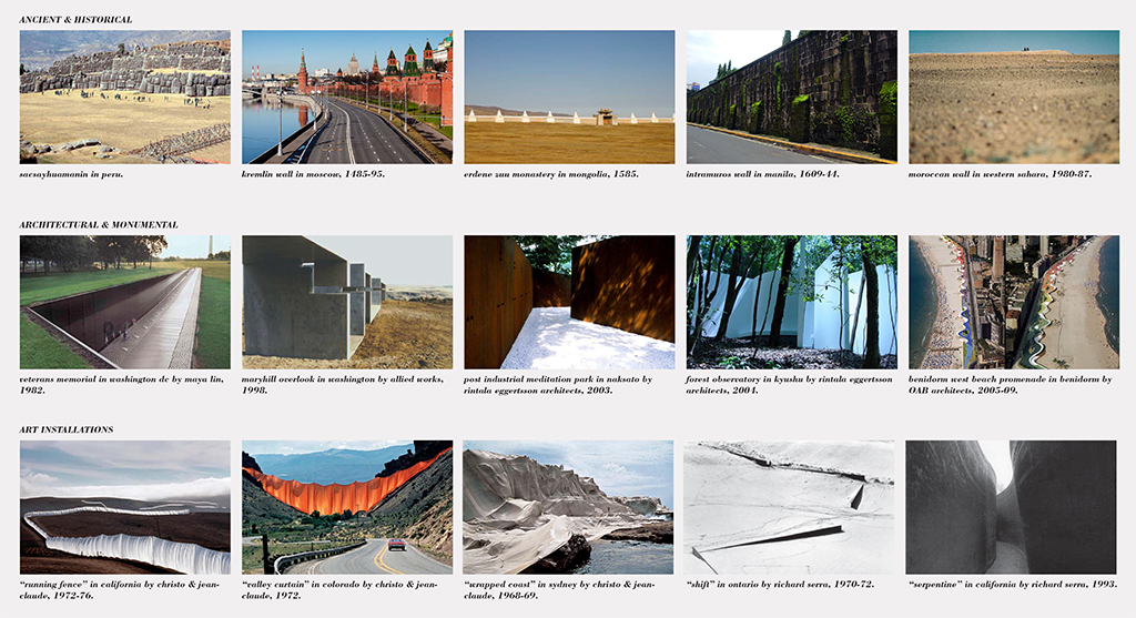
Series
Studio Reports
Student research and propositions from design studios with real-world implications.
We are celebrating 15 years — and counting — of stories that are deeply researched and deeply felt, that build a historical record of what the city has been.
Next week, ten teams of architects, planners, engineers, and scientists (among others) will unveil the results of more than seven months of research and design development into strategies for rebuilding and adapting coastal areas hit particularly hard by Hurricane Sandy. These proposals are the result of Stage 3 of Rebuild by Design (RBD), a competition launched in June 2013 by the US Department of Housing and Urban Development (HUD) and its Hurricane Sandy Task Force to address “structural and environmental vulnerabilities that Hurricane Sandy exposed in communities throughout the region and [to develop] fundable solutions to better protect residents from future climate events.” Following an open Request for Qualifications (Stage 1 of the initiative), ten interdisciplinary teams were selected to participate in Stage 2, three months of research, analysis, and community outreach culminating in the identification of 44 “design opportunities.” The competition jury selected one idea from each team to be further developed into buildable, fundable projects. These final plans will be revealed to the public next week, and the RBD jury will select an undetermined number of winning proposals to be implemented using a combination of public and private funding, including HUD Community Development Block Grant Disaster Recovery monies set aside specifically for this venture.
The size and scope of this initiative demanded teams of equal measure. Architects and infrastructure engineers joined forces with ecologists and cultural planners. Water management specialists and landscape designers partnered with finance strategists and communications experts. And a number of teams looked to the region’s academic institutions for collaboration. Bjarke Ingels, Daniel Kidd, and Jeremy Alain Siegel of BIG Bjarke Ingels Group, leader of the Rebuild by Design BIG Team, were planning a third-year M.Arch studio at Parsons for the semester that coincided with RBD Stage 2. They saw the competition brief as a win-win opportunity: by using the competition as the studio focus, they could incorporate the design ingenuity and research skills of their students into their team, while also introducing the students to a particularly complex design process — with all of the logistical headaches and genuine potential for impact that come with it. Here, in advance of next week’s reveal of the final Rebuild by Design proposals, Daniel Kidd looks back at how this design studio informed BIG Team’s early competition research, and shares some of the results of the students’ work. –V.S.
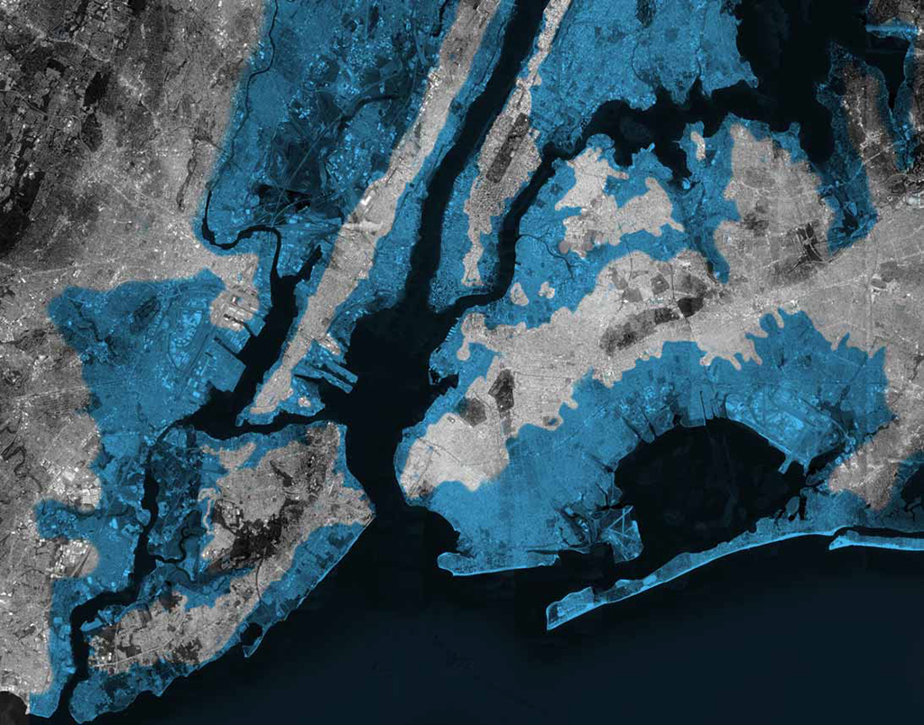
Projected sea level rise by 2050 | Blue Archipelago | Megan Hershman & Rebecca Rand
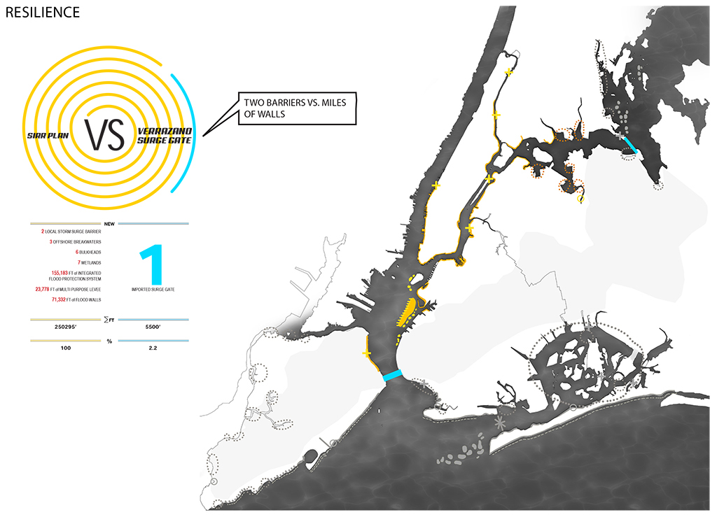
When we began planning this studio a few months before the Fall 2013 semester, we knew we wanted it to be a Manhattan response to Hurricane Sandy. Mayor Bloomberg’s “Special Initiative for Resiliency Report” (SIRR) was relatively recent, and the Department of City Planning’s proposed midtown rezoning was Parsons’ recommended studio topic for the semester. A few weeks later BIG officially made the shortlist for Rebuild by Design (RBD), an international design competition conceived as a lightning rod for federal funding in high- and low-density areas of the Eastern region that needed rebuilding or protecting. We realized that instead of inventing our own fictional brief around rezoning and floodproofing, we should use the brief we received from Rebuild by Design as the template. Responding to the RBD brief was a perfect primer for the M.Arch students’ upcoming thesis semester. I have never seen a closer real-world parallel to the framework of the academic thesis. The scope was only vaguely defined. Our site could be as big as the entire Sandy-affected region, or as small as a single building. For the BIG team, the area of focus was “High Density Urban Environments,” a term which simplifies the scope geographically, while compounding the political complexity. New Jersey and New York were the primary areas of interest, but for the sake of the studio having a common pool of research, we ultimately focused on the five boroughs of New York City.
When we presented at the studio lottery, we told the students they would be our collaborators, and in many ways we thought of ourselves as co-students with the same brief. Attempts to distinguish “our work” from “student work” often become nebulous for this very reason. The studio became an extension of the BIG team, just as members of the team extended into the studio. Our consultant team of engineers, hydrologists, landscape architects, development advisors, and others became regular critics in the studio. This double exposure provided distinct testing grounds for both parties: a continual reality check and an open arena for ideas.
On our first review of the Rebuild By Design competition outline, it was clear that the potential scope of the project was vast and would be painfully difficult to distill into something of an architectural scale, or even in some cases into a tangible urban scale. The site(s) we chose needed to be both specific yet prototypical. Implementation was conceived on various scales of time and geography. Silos of political interests ranging in scale from federal to city, from community board to community member, ALL had to be considered and kept in constant dialogue.
The mandate was clear. This was, and still is, a real project in a real state of urgency. There is no room for fiction. Ideas generated by the students were to be held to the same criterion as our own; they must be plausible, and must do more than provide a utilitarian solution for the city. They must protect from floodwater while creating synthetic social relationships. The Army Corps can build a concrete wall. Design should be able to do much more.
The “sharp-shooter fallacy” warns against painting a target around a bullet that has already hit its mark. In the RBD studio we were recalibrating and firing out design proposals daily. We sent shots into a foggy political and logistical environment, and one that is constantly in flux. Our exposure to these ever-changing requirements persisted up to the final studio deadline — in some cases, causing drastic rethinking of engineering premises, and political pragmatism, even days before the final project.
The ballistic arc of the Parsons work from inception to completion was helpful shorthand for the real thing. And while my task is to summarize the final projects, it would be just as interesting to list a few of the misfires and off-target attempts. Public space, for example: at times floodwalls felt like prison walls incarcerating Manhattanites. A few public housing lots in the Rockaways were politically caustic, forcing one student to change his proposed site within days of the final presentation. Some proposals searching for a site jumped back and forth from Manhattan to Brooklyn, while others did the same from river to river. One common theme for all projects was a constant reassessment of engineering assumptions as a cause for redesign. Project titles below have a strikethrough to indicate a few of the shots each student took in the search for their final target.
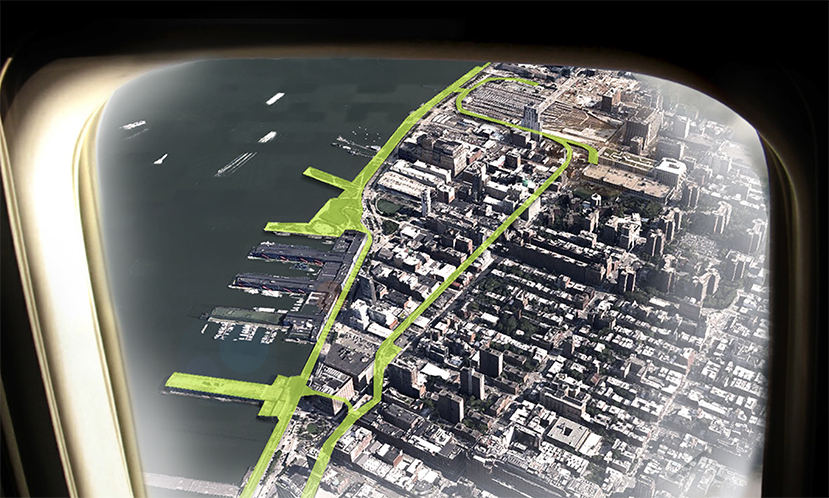
The BIG team’s “final” proposal responded to the RBD brief with a project dubbed “The BIG U.” We ultimately narrowed down our list of potentials into three pilot projects around the lower lip of Manhattan from West 53rd Street to East 42nd: 1) The Battery, 2) Two Bridges, and 3) East River Park. The eight-month process of the RBD competition has now more than doubled the total duration of the studio, and our discussions with government and community groups resulted in many changes since. Still, much of what we set our sights on during discussions at Parsons have survived in some form in BIG’s current proposal for RBD. This was always the hope, and we are grateful to have this team of “sharp shooters” from Parsons be a part of the BIG U.
STUDENT PROJECTS

The Serpentine Promenade | Jessica Kwok & Oni Lloyd | Click the image to see more of the Serpentine Promenade
The Serpentine Promenade | Jessica Kwok & Oni Lloyd
The Serpentine Promenade | Jessica Kwok & Oni Lloyd
The Serpentine Promenade | Jessica Kwok & Oni Lloyd
The Serpentine Promenade | Jessica Kwok & Oni Lloyd
The Serpentine Promenade | Jessica Kwok & Oni Lloyd
Flood Wall
Art Wall
This is Not a Wall
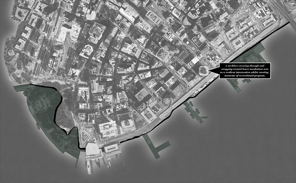
Project: The Serpentine Promenade
Location: Lower Manhattan
Design Team: Jessica Kwok & Oni Lloyd
“Our approach to designing a resilient urban strategy in NYC was to work within the parameters of a smaller-scale cross-pollination of architecture and installation. We believe that big-scale problems do not necessarily require big-scale solutions. Our sculptural promenade weaving in and around lower Manhattan offers programmatic moments of contemplation and reflection, whilst making the smallest impact on the existing site conditions.”
— Jessica Kwok and Oni Lloyd
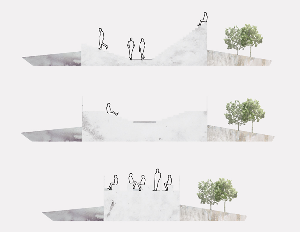
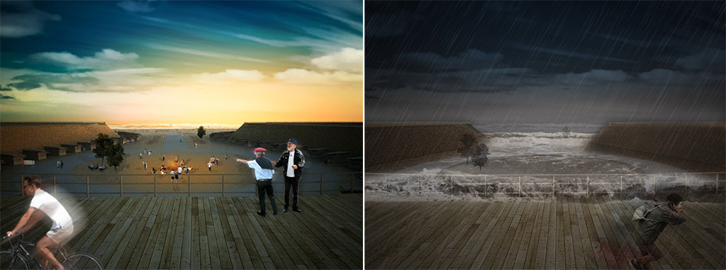
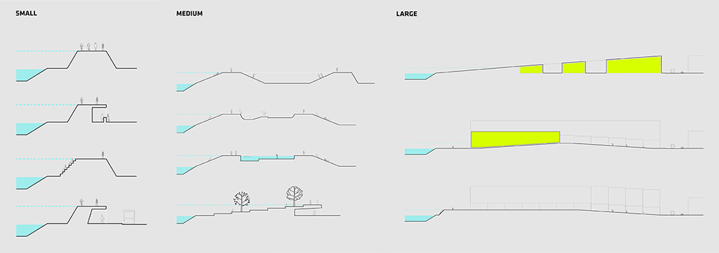
The simplicity of this approach was an instant relief. The problem was very complex, but the solution was simple: determine the height of floodwater that needs to be held back and build something at least that tall. Once this premise had been established, Jessica and Oni were able to produce a vast amount of research on floodwall and art wall typologies.
How can we make a barrier not feel like a barrier? A continuum of protection must not sacrifice public connection to the water. By imbuing the utilitarian with the beautiful a sculptural synthesis was born. The result is a meandering promenade following the path of least resistance from Battery Park to Brooklyn Bridge.

The Dry Line | Veronica Acosta | Click the image to see more of the Dry Line
The Dry Line | Veronica Acosta
The Dry Line | Veronica Acosta
The Dry Line | Veronica Acosta
The Dry Line | Veronica Acosta
The Dry Line | Veronica Acosta
The Dry Line | Veronica Acosta
Waterfall Wall
Hudson River Park Berm
Arts & Culture Loop
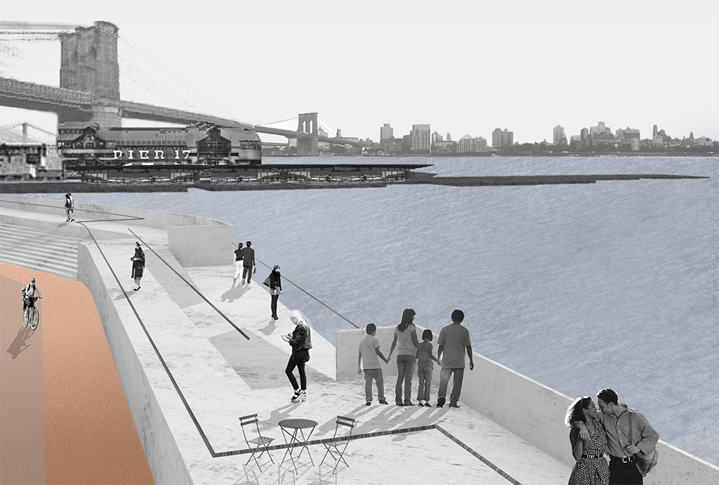
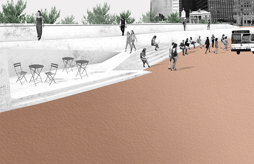
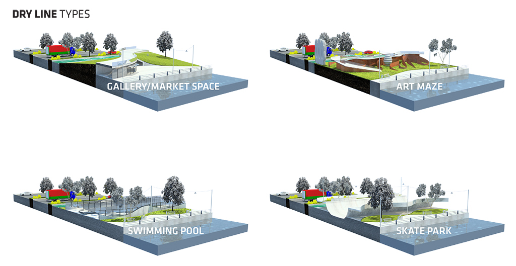
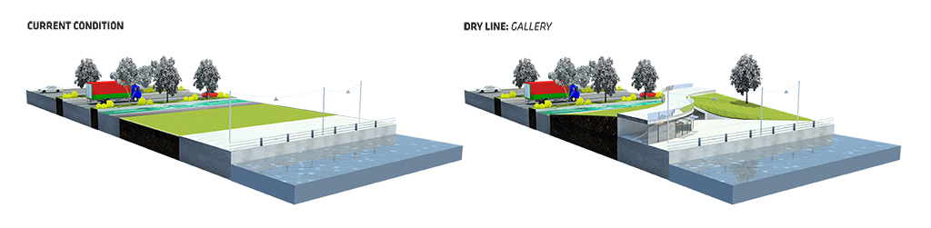
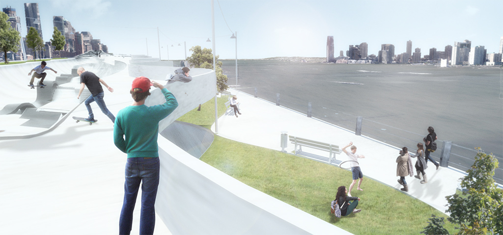
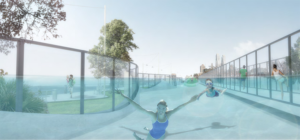
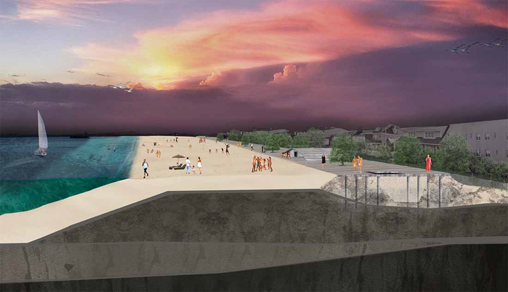
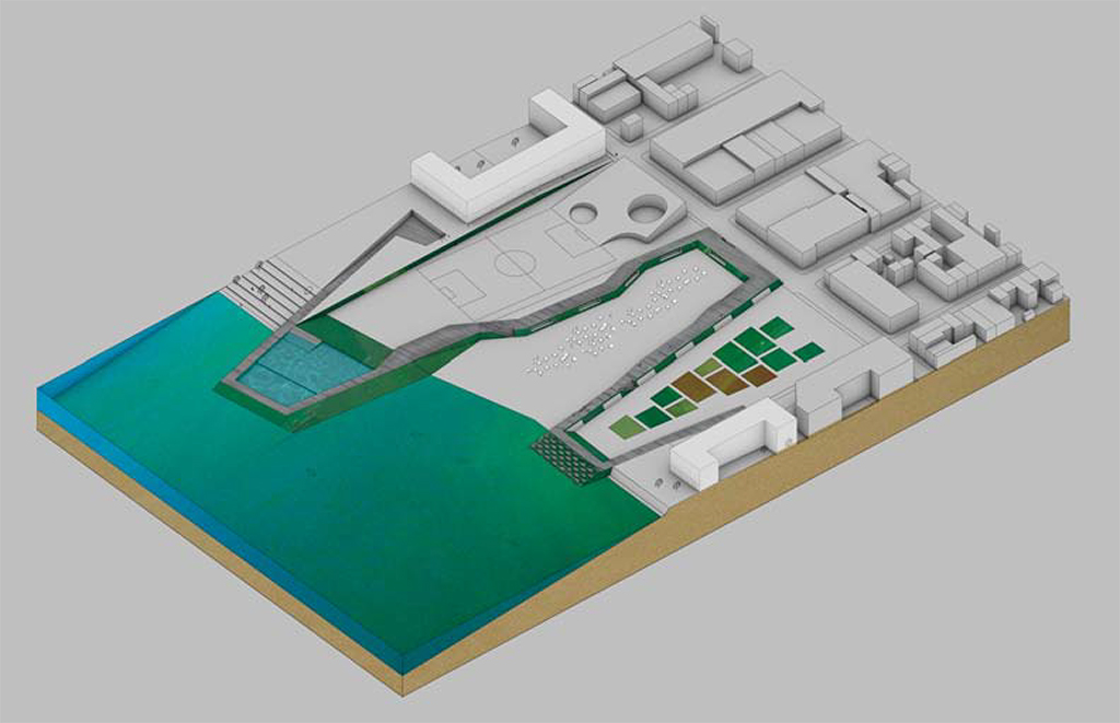
Project: The Dry Line
Location: Chelsea, Manhattan
Designer: Veronica Acosta
“The proposed Dry Line is situated on the Hudson River Park. It is a walkway elevated 9’ to act as a barrier between a possible flood and the city, turning a strip of the park into infrastructure for flood protection. The walkway is continuous, but the room beneath and around it is the variable that morphs to invite different programs along the shore, mediating the strip between the Hudson River and the West Side Highway. Some of the options explored are a skate park, gallery/market space, a swimming pool, and a sculpture art maze. The solution is meant to be scalable to encompass the entirety of Manhattan’s 32-mile shoreline. In the case of a flood emergency the entrances to the park close with watertight floodgates.”
— Veronica Acosta
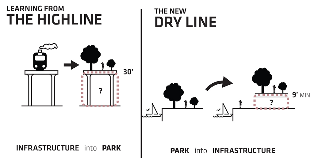
From the beginning Veronica had a focused approach. As a resident of the Chelsea neighborhood she was witness to the inundation of the neighborhood during the storm. Many of the ideas we developed with Veronica helped to anchor the eventual thesis of BIG’s approach. She was quick at turning ideas into sketches, and sketches into a robust catalogue of synthetic infrastructure. And while all these variations in the catalogue seemed to compete with one another for all of our time and attention, we soon realized that the catalogue is the perfect way to show the potential to tailor the physical and programmatic qualities of each defense strategy to fit the desires and needs of each neighborhood around the bulkhead of Manhattan. It was exactly the prototypical-yet-specific quality asked for in the RBD brief. Veronica further developed this concept in the arts district of Chelsea and transformed Hudson River Park into a multivalent system for protection, recreation, and many other opportunities. Ultimately the pinch points of the High Line were joined to form an elevated loop, transforming the High Line into the “Dry Line,” a continuous protective halo around Manhattan’s celebrated arts district.
Blue Archipelago | Megan Hershman & Rebecca Rand | Click the image to see more of Blue Archipelago
Blue Archipelago | Megan Hershman & Rebecca Rand
Blue Archipelago | Megan Hershman & Rebecca Rand
Blue Archipelago | Megan Hershman & Rebecca Rand

Blue Archipelago | Megan Hershman & Rebecca Rand
Park(ing) as Water Storage
The Dutch Polder “Islands”
Intentional Breach, Strategic Retreat
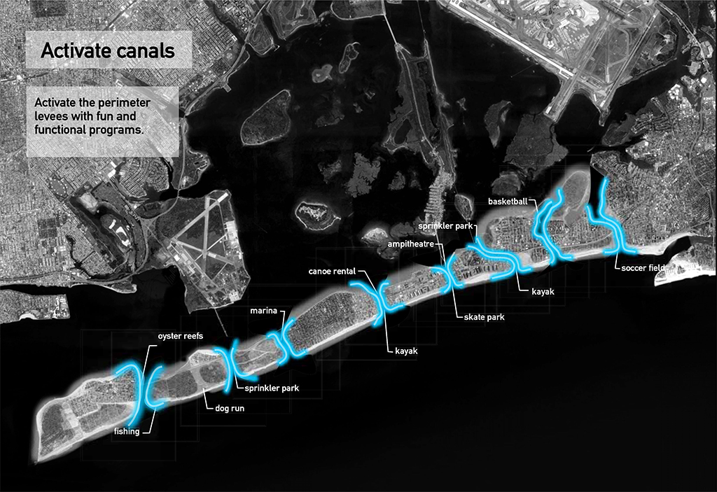
Project: Blue Archipelago
Location: The Rockaways, Queens
Design Team: Megan Hershman & Rebecca Rand
“The Rockaways are reshaped into a series of protected islands, allowing potentially catastrophic tidal forces to occur alongside existing infrastructure, development, and new water-based recreation!”
— Megan Hershman & Rebecca Rand
Megan and Rebecca nearly hit the mark on their first attempt. The trick was convincing them that they had something that was plausible. Using the Dutch “Polder” concept where government relocates residents onto man-made hills, the team was able to come up with a compelling argument for strategically retreating from parts of the Rockaways that will almost certainly be permanently at risk of inundation in the future. Breaches in the Rockaways that had occurred naturally actually improve the water quality in Jamaica Bay by allowing pollutants to escape the bay. Their final proposal slices through the short length of the Rockaways, cutting it into a dashed line of urban islands linked by existing critical infrastructure.
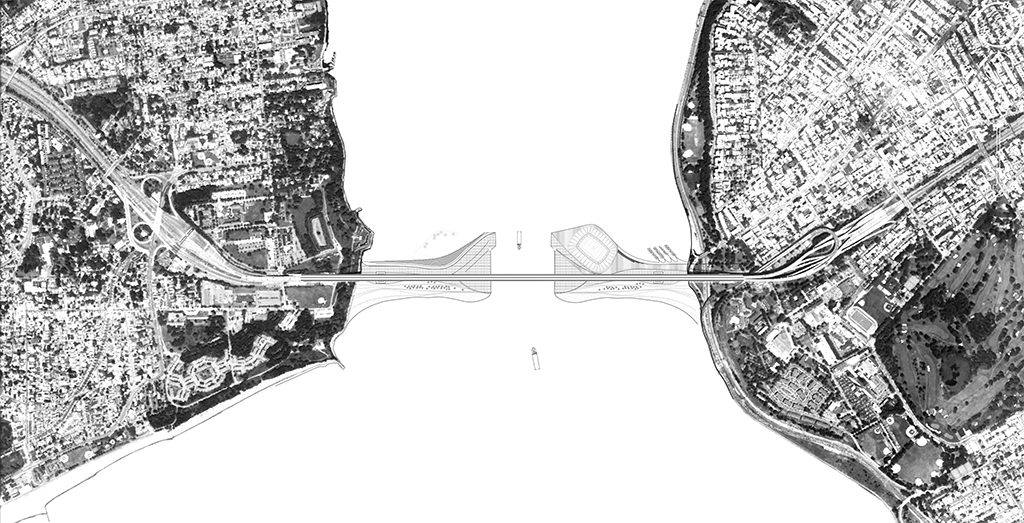
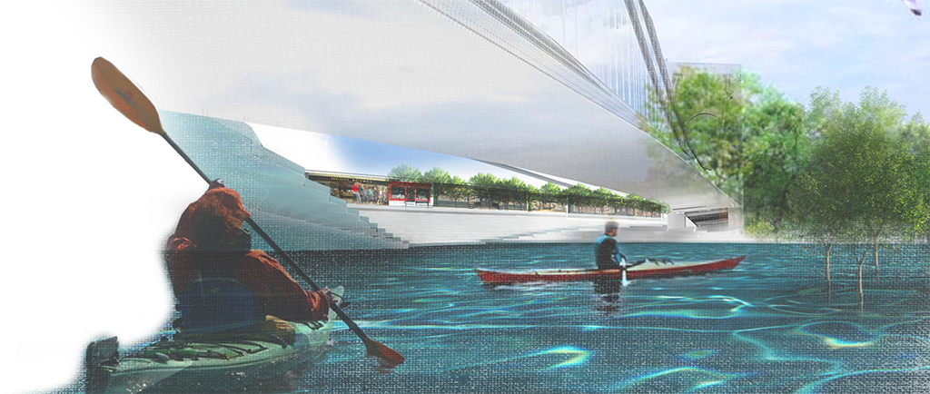
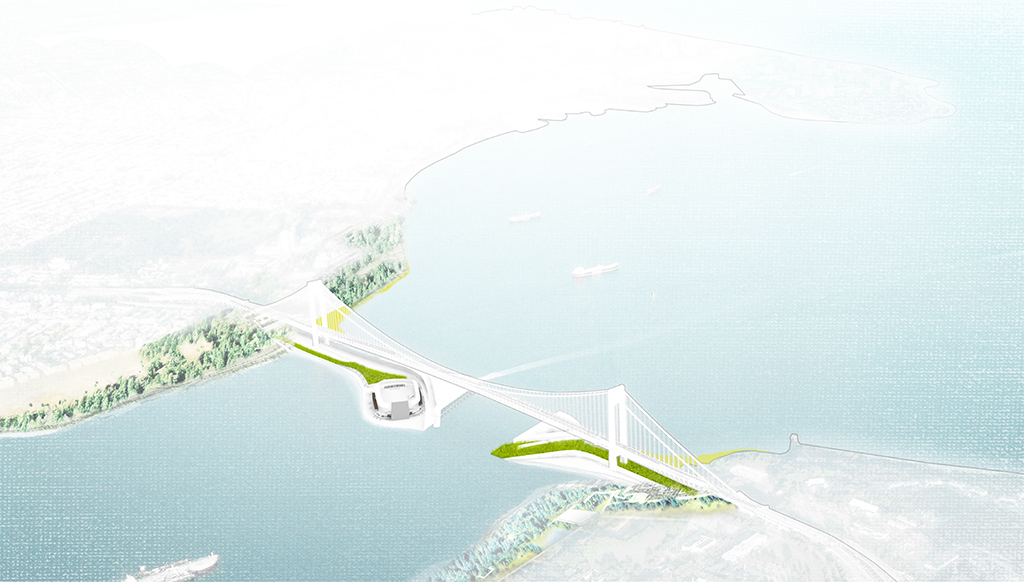
The Narrows | Dawn Marie Polak & Vera Leung | Click the image to see more of The Narrows
The Narrows | Dawn Marie Polak & Vera Leung

The Narrows | Dawn Marie Polak & Vera Leung

The Narrows | Dawn Marie Polak & Vera Leung
The Narrows | Dawn Marie Polak & Vera Leung
The Narrows | Dawn Marie Polak & Vera Leung
The Narrows | Dawn Marie Polak & Vera Leung
Urban Lily Pad
Brooklyn Bridge Gate
Verrazano-Narrows Bridge Barrier
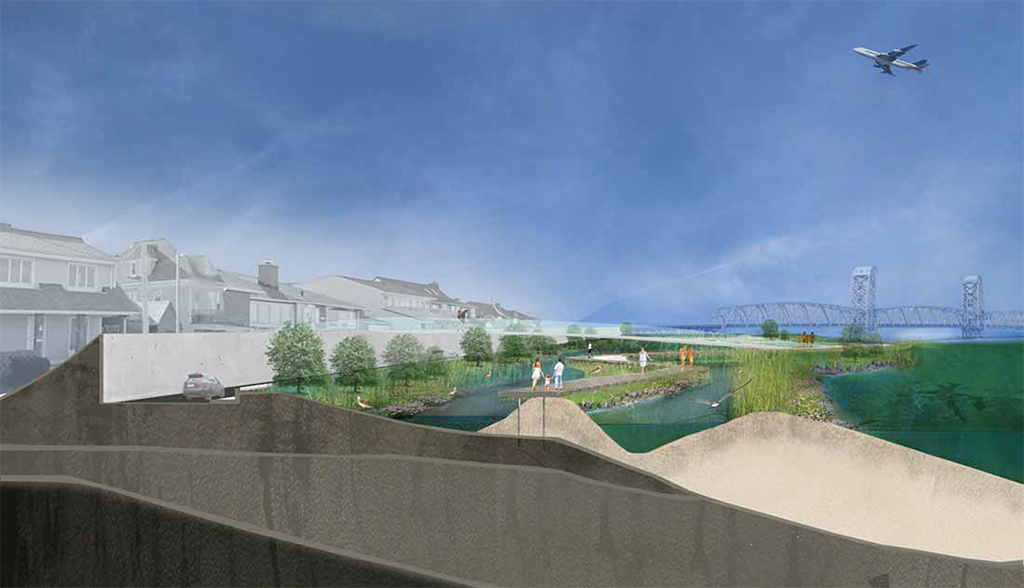
Project: The Narrows
Location: Verrazano-Narrows Bridge / Brooklyn & Staten Island
Design Team: Dawn Marie Polak & Vera Leung
“This proposal re-evaluates the idea of implementing a large-scale infrastructural solution, the surge gate, at the entrance to the New York Harbor by coupling it with social and civic program. … Can this crucial infrastructure activate a harbor district and create a water community?”
— Dawn Marie Polak & Vera Leung
From the beginning Dawn and Vera were water focused. Rather than trying to design ways to keep water out of the urban realm, they were continually trying to bring the urban out to the water — beginning with a Lily Pad Park-scape that bridged between the tip of Lower Manhattan eastward to connect to Brooklyn Bridge Park. Perhaps this team, more than others, experienced firsthand a significant reality check. Enviro-politically it was caustic to build directly on water, and the potential ecological ramifications of building a structure in that particular location were unclear. This forced the team to shift from the Brooklyn Bridge to the Verrazano-Narrows, where a standard surge barrier had been proposed by Arcadis’ team of Dutch hydrological engineers in 2009: a standard system ripe for a redesign as social infrastructure. Given these obstacles, the ultimate result was a vibrant urban link between two coastlines beneath the Verrazano-Narrows Bridge, bringing not only protection but also improving both urban edges that formed its roots.
SURFURBIA | Mateusz Rek | Click the image to see more of SURFURBIA
SURFURBIA | Mateusz Rek
SURFURBIA | Mateusz Rek
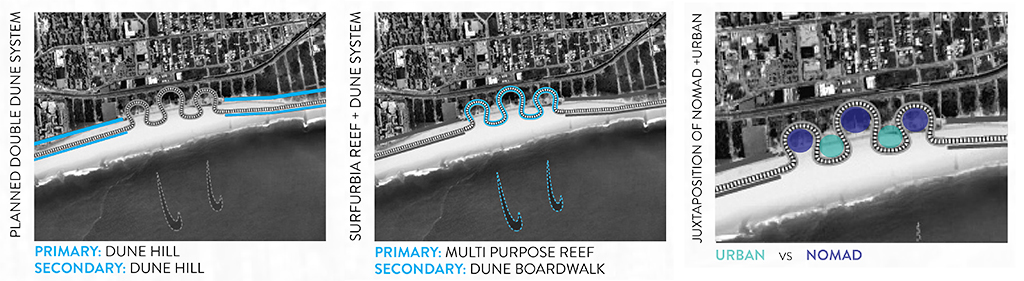
SURFURBIA | Mateusz Rek
SURFURBIA | Mateusz Rek
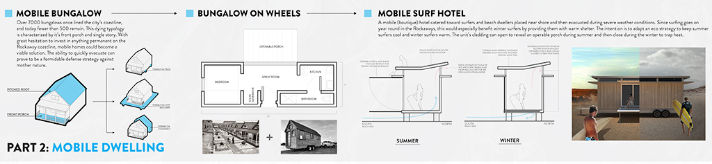
Deployable Housing
Fighting Water with Water
Resilient Wave
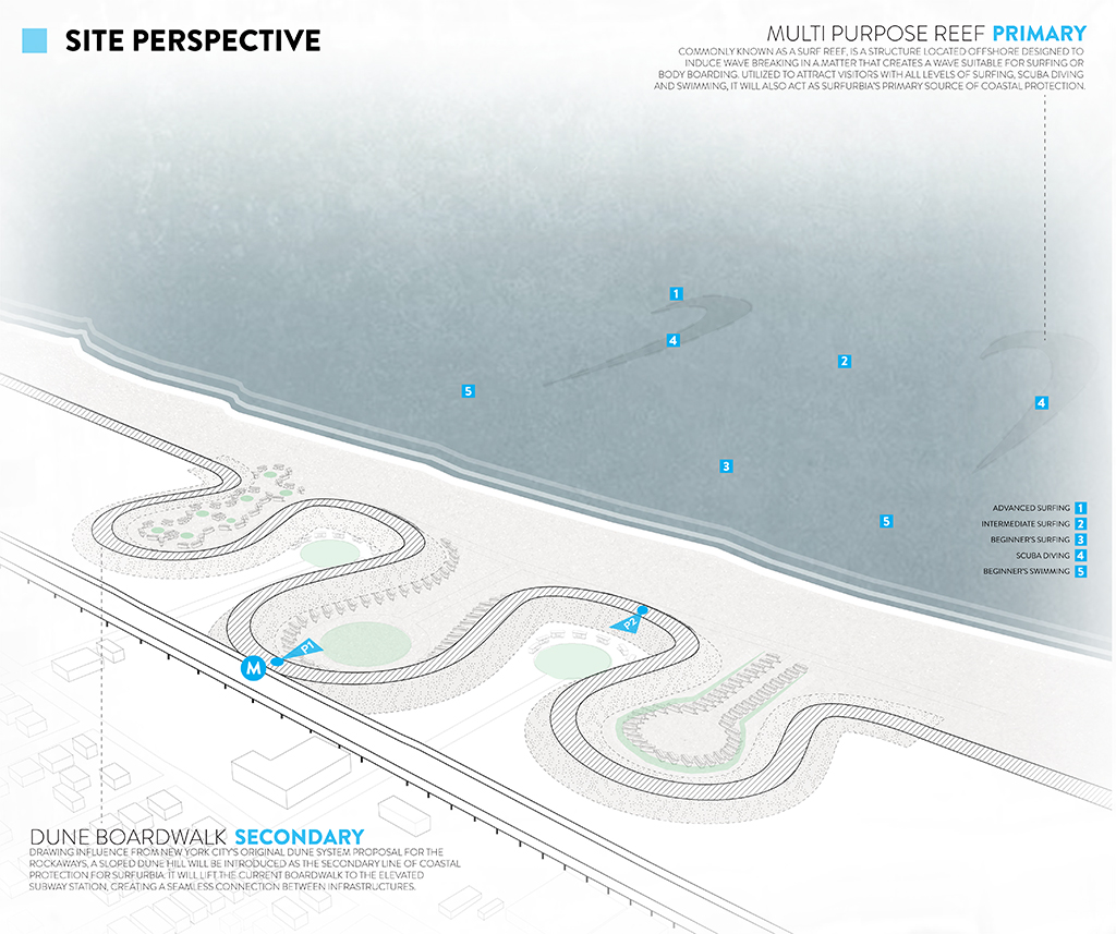
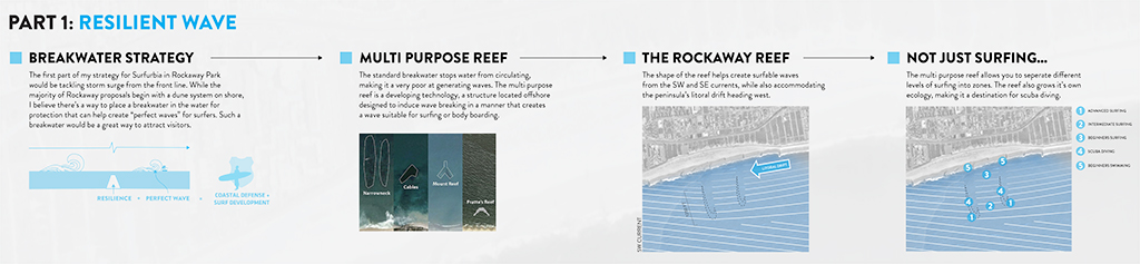
Project: SURFURBIA
Location: The Rockaways, Queens
Designer: Mateusz Rek
“Devastated by Hurricane Sandy, the high-density, low-income Rockaway Park area will begin its revitalization with a new surf culture and sense of community. SURFURBIA will implement a breakwater reef that provides coastal protection, surfable waves, and mobile housing that allows for hurricane evacuation.”
— Mateusz Rek
Another bullseye. On day one Mateausz had the idea to somehow use permanent aquatic, rather than land-based, infrastructure as resilience. After several weeks of research on breakwater reefs and the creation of the perfect wave, he had a compelling case which was vetted by our engineers and surfer/landscape architect Walter Meyer. Once the premise had been set, it was time to assess its implications. This kind of breakwater can reduce damage by wave action but does little for the surging height of the water. As we discussed in Megan and Rebecca’s “Blue Archipelago,” the Rockaways are at high risk, and retreat is one viable option in some parts of the island. After several misfires into public housing sites that would require demolition, “SURFURBIA” was relocated to a more neutral location. The community of “SURFURBIA” proposes a nomadic occupancy on only a small swatch of land, but one that has the potential to drive massive recreational, cultural, and economic activity for the Rockaways.
The Brooklyn Elastic Berm | Alvaro Velosa | Click the image to see more of the Brooklyn Elastic Berm
The Brooklyn Elastic Berm | Alvaro Velosa
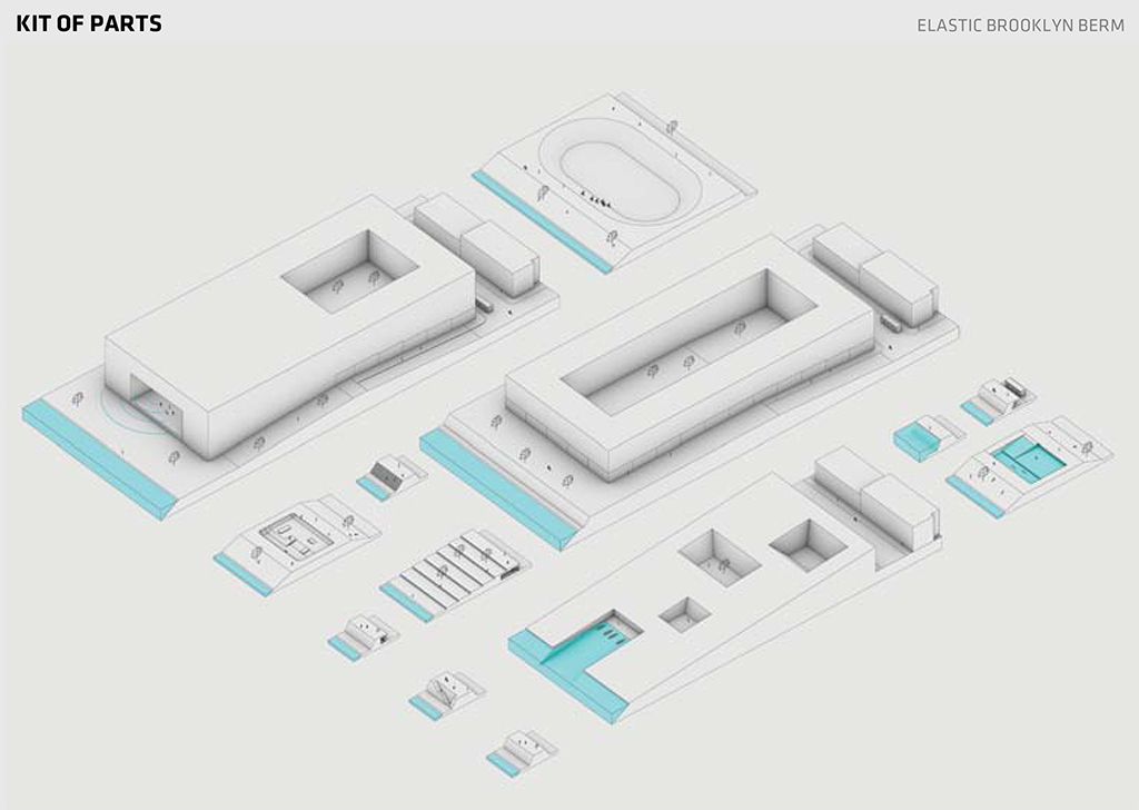
The Brooklyn Elastic Berm | Alvaro Velosa

The Brooklyn Elastic Berm | Alvaro Velosa
The Brooklyn Elastic Berm | Alvaro Velosa
Stormwater Retention
Blocking Water Block by Block
The Culture Berm
Project: The Brooklyn Elastic Berm
Location: Greenpoint, Brooklyn
Designer: Alvaro Velosa
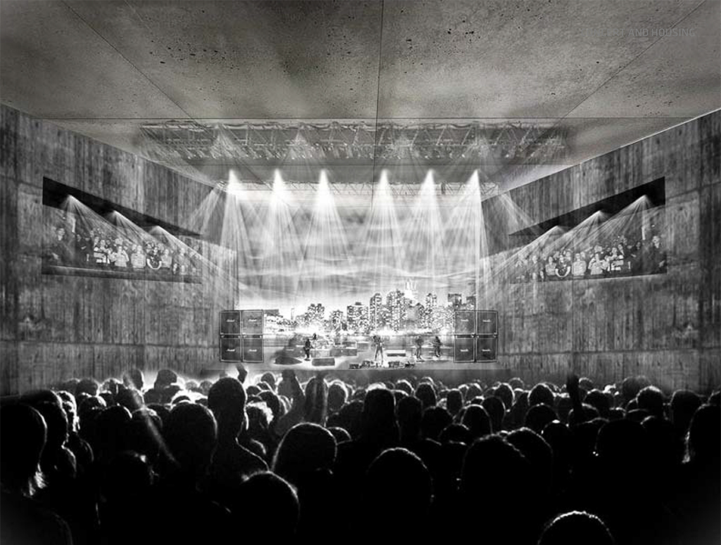
“The Brooklyn Elastic Berm seizes the opportunity of Greenpoint’s transforming waterfront to enable smart growth in a former industrial area. It does this by stretching the berm, a typical form of flood defense, to distances similar to a city block. In doing so the berm disappears, allowing for a continuous waterfront where people can enjoy open-air concerts and live in low rise housing near the water’s edge. … Resilient infrastructure plays a vanishing act on a transforming waterfront!”
— Alvaro Velosa
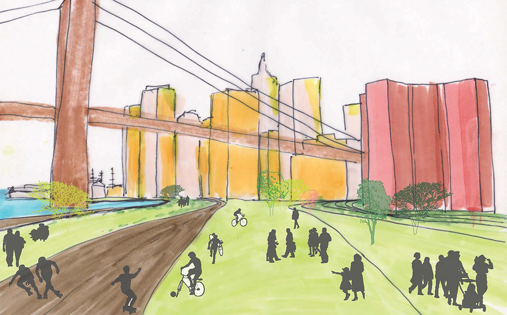
Alvaro had a knack for thinking about scale. His early narratives approached each scale of the brief — region, city, district, neighborhood, building, material — in the style of “Powers of Ten.” This was a vein of research that proved hugely beneficial to the whole team, forcing us to consider the different types of ammunition that could be launched at the same target. Alvaro’s early work spanned the breadth of the Brooklyn waterfront down to the percolation qualities of ground treatments at the material level. It was near the midterm when he found a masterplan for developing Greenpoint (one of Brooklyn’s most flood-prone neighborhoods) that included no resiliency measures, despite being released one year after Hurricane Sandy. In response, his “Brooklyn Elastic Berm” envisioned a full city block from east to west as a berm. Using the full block dimension it was possible to make the berm disappear from view in some cases, and provide a myriad of dips and pockets which could be adapted to cultural programs for Greenpoint’s waterfront.
Subverting Robert Moses | Rose Bothomley | Click the image to see more of Subverting Robert Moses
Subverting Robert Moses | Rose Bothomley

Subverting Robert Moses | Rose Bothomley
Subverting Robert Moses | Rose Bothomley
Subverting Robert Moses | Rose Bothomley
Subverting Robert Moses | Rose Bothomley
East River Lily Pads
The Brooklyn Berm
Lost Highway — Gained Protection
Project: Subverting Robert Moses
Location: Lower East Side, Manhattan
Designer: Rose Bothomley
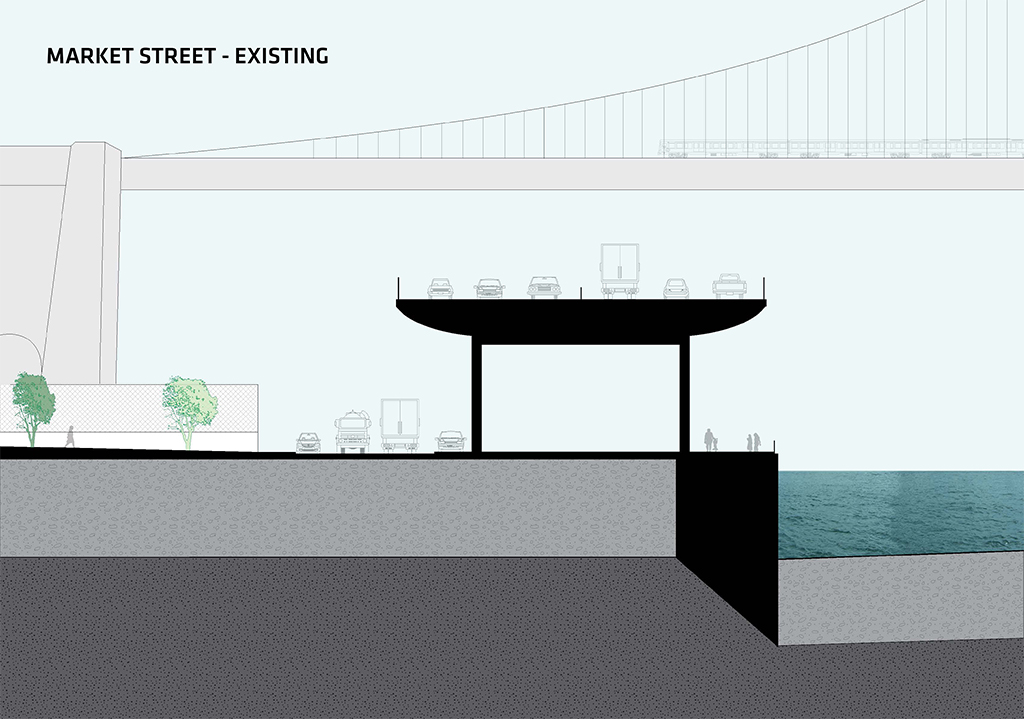
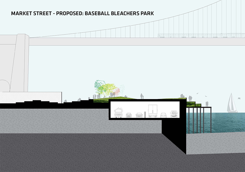
“By partially burying the outdated and unsightly FDR elevated highway on the Lower East Side, we can create the beginning of a protective berm and a new East River Park. The new Manhattan Bike Line would sit atop this berm, flanked by walking paths, sloping parks, and increased access to the riverside. Added programs include: bleachers to watch local high school softball games, a picnic/family park, and a world class sculpture park, all surrounded by views of the Brooklyn and Manhattan Bridges and New York City.”
— Rose Bothomley
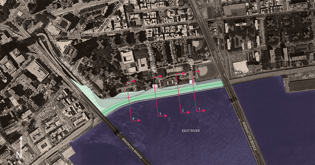
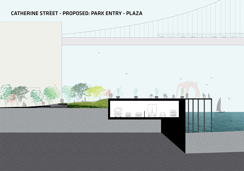
Rose presents us with a bold vision — one that BIG also proposes to some extent in our final project for RBD: to bury the FDR Highway on Manhattan’s Lower East Side. A relic of Robert Moses’ obsession with weaving highways into the tapestry of New York City, the FDR is now nearing the end of its life and will soon need repair or dismantling. This presents an opportunity when paired with the need for resiliency. If you could partially submerge the highway so that it remained above ground at just the appropriate height that it also held back storm water, you could simultaneously provide two infrastructural improvements with the added benefit of insulating the public space from the noise and fumes of the highway. Launching from this premise, Rose continues “Subverting Robert Moses” with the insertion of a Manhattan bike lane atop the new berm, connecting the new greenspace as an amenity for nearby low-income housing.

Gowanus Canal(s) | Guilherme Arnon | Click the image to see more of Gowanus Canal(s)
Gowanus Canal(s) | Guilherme Arnon
Gowanus Canal(s) | Guilherme Arnon
Gowanus Canal(s) | Guilherme Arnon

Gowanus Canal(s) | Guilherme Arnon

Gowanus Canal(s) | Guilherme Arnon
Red Hook
Newton Creek
Gowanus “Sponge”
Project: Gowanus Canal(s)
Location: Gowanus, Brooklyn
Designer: Guilherme Arnon
“Gowanus Canal(s) focuses on the Gowanus canal area in Brooklyn. Looking at the site’s past, when the Dutch were still there, it used to be a marsh area composed by a network of canals. Any floods were absorbed by this sponge-like system, which also used to be home to numerous animal species. The canal we know today has suffered from the city’s industrial period in which the marshy lands were filled, creating only one canal surrounded by industries and resulting in deep contamination of the water and land. My proposal aims to recreate the original network of canals, allowing the people to live by the water on mixed-use buildings, while it creates resiliency through a multi-level approach. The three main goals are to clean the water, create resiliency, and provide a pleasant place to live.”
— Guilherme Arnon
Guilherme (Gui) was scattershot in the best sense of the word. He conducted precedent analysis at a thesis level for cities with “wet feet,” including canal cities and other amphibious urban conditions. He applied this research to an “Urban Sponge” for the Gowanus Canal area of Brooklyn. The sponge not only allowed the dispersal and absorption of surge and stormwater, but also incorporated a phytoremediation strategy using plants and UV light to clean the notoriously contaminated brownfield of the Gowanus.
The views expressed here are those of the authors only and do not reflect the position of The Architectural League of New York.
Student research and propositions from design studios with real-world implications.