
We are celebrating 15 years — and counting — of stories that are deeply researched and deeply felt, that build a historical record of what the city has been.
We are celebrating 15 years — and counting — of stories that are deeply researched and deeply felt, that build a historical record of what the city has been.
Brian House and Jesse Shapins were two of the co-creators of Yellow Arrow, an early locative media arts project and social software platform. In summer 2008, they co-taught the studio/seminar “Critical Urban Media Arts” at Columbia. Here, they discuss the conceptual background of the course and the pedagogical methods they developed, including Periplurban, a new platform for urban media research.
“Art exists that one may recover the sensation of life; it exists to make one feel things, to make the stone stony. The purpose of art is to impart the sensation of things as they are perceived and not as they are known. The technique of art is to make objects ‘unfamiliar,’ to make forms difficult, to increase the difficulty and length of perception because the process of perception is an aesthetic end in itself and must be prolonged.” —Viktor Shklovsky, “Art as Technique” (1917)
The internet has opened up some tremendous opportunities for new methods of representing cities. With the rise of platforms such as Google Maps, in particular, a whole subfield of urban media arts has evolved, driven by the ability to attach photographs, videos, sounds or text to specific places on a map. Projects within this subfield – whether produced by an individual artist or consistently evolving through new user contributions – work with the assumption that the traditional map or aerial photograph, now open for re-interpretation and annotation via the internet, must be the basis for a new cartography. What do you see as some insights these projects offer and some of the problems associated with these works?
Well, mapping platforms such as Google’s typically begin with the traditional, Cartesian representation inherent to geo-data. That’s problematic because it’s so reductive. These reductions may be subconscious, so all the more reason to address them artistically and pedagogically. A map begins with a view of the streets in a very car-centric navigational mode; at first, Google Maps didn’t even include subway stops for New York City, so we are clearly not starting from a point of concern for how different environments operate on the street level, especially not from a pedestrian’s perspective. Now, of course, Google has “Street View”, which is a pretty awesome database of panoramic images for streets in major cities. But its frozen perspective and positioning as an objective representation of the street further highlight the challenge at getting from a mapping platform to more complex urban dynamics.
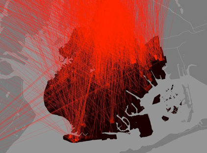
However, when you can take the set of expectations that come along with this kind of traditional map and add an unexpected dimension that reveals something orthogonal to that vision of space, then you really have something. For example, I think that Million Dollar Blocks, by Laura Kurgan and the Columbia Spatial Information Design Lab, is a great example of this. You still have streets delineating blocks in the city, but you have changed the value of those blocks to represent something more socially potent: the dollar amount spent by the government to incarcerate the people who lived there. Online projects often miss this kind of transformation; plotting ephemera on a Google map might be momentarily interesting, but I think it’s far more satisfying to try and change the meaning of the map substrate to some creative end.
Can we bring that transformed idea of space into the experience of place? How do we evaluate the relationship between the experience of place through a conventional computer screen and the experience of a subject actively engaged on a city’s streets? I’d say that the classic geocaching is a great example of a project that plays with the tension between the representation online and experience in the real world. Geocaching.com publishes the latitude/longitude of the caches, which can be easily shown on a Google map. So where’s the fun in that? Well, the fun is actually getting there and navigating the physical and social obstacles the real world presents; climbing a tree in Inwood can’t be described by a Google plot, but seeing the map can motivate you to attempt it.
Yes, that’s exactly it; designing for the street is the inverse of the computer screen. Instead of adding dimensions, you need to reduce them. This is what we do everyday: the pedestrian is trained to block out what is habitual and focus on the task at hand, such as getting to the office. But if artists can provide an alternative reduction of what the city has offer, we can mine a lot of depth from what would typically be ignored.
Yellow Arrow1 was a project that specifically worked along these lines. People received stickers in the shape of yellow arrows; printed on each one was a unique alphanumeric code and telephone number. Participants were invited to place the sticker anywhere they chose. Then, by sending a text-message with the sticker’s code to the telephone number and including an original statement about the location, the person was able to attach a message to that actual place. When someone else saw the sticker and sent a text with the code to the phone number, he or she received the person’s original message. Additionally, the two individuals could then communicate directly (but anonymously) by sending texts back and forth through the Yellow Arrow phone number. The screen-based dimension comes in later, as users are able to upload photographs of their arrows and plot their exact locations on an online map.
Although it may seem obvious, I think it’s important to keep in mind that sending a Yellow Arrow text-message on the street is always going to feel very different than seeing a top-down representation of arrows plotted on a city map. But it’s a complementary experience, and one motivates and brings insight to the other. With the inexorable technological advances of mobile devices, there is some danger in collapsing these two modes into a single means of experience. If I am walking around Manhattan and following my progress on an iPhone screen, I haven’t reframed my perception of the environment so much as inhibited it. This amounts to a commodification of my experience by the provider of that particular service, who is then free to exploit my attention.
“If artists can provide an alternative reduction of what the city has offer, we can mine a lot of depth from what would typically be ignored.”
I think our proposition is critical in that it insists upon an urban media arts practice that explicitly challenges this kind of commodification of everyday life. In general, one of the products of the explosion of the internet and the widespread adoption of mobile phones has been an ever-increasing commercialization of all hours and dimensions of human experience. While I feel that we must embrace the technology, it does not mean we have to embrace the use-assumptions of the technology’s producers or to refrain from developing our own tools.
I think that’s really the underlying motivation for developing our own pedagogical platform with Periplurban. When we began formulating our workshop on issues of urban research, representation and mapping, we wanted to build upon the experiences of experimenting at the interface of the physical and virtual city from Yellow Arrow to loosely formulate a media-based practice of street-level, critical investigation in the city. At a party, I was introduced by a mutual friend to a fan of Yellow Arrow. When he learned that I was a co-creator, he exclaimed ‘The Periplum!’
I had only a passing familiarity with Ezra Pound, but when he explained the metaphor, I thought it captured the poetic aspect of that project quite well: in his Cantos, Pound uses “periplum” to describe both mapmaking and history as seen from the point-of-view of a poet. Rather than taking the conventional bird’s-eye view of the cartographer or historian, the poet is a voyager personally navigating space and time. When we needed a name for the platform we developed for the course, the neologism Periplurban suggested itself.
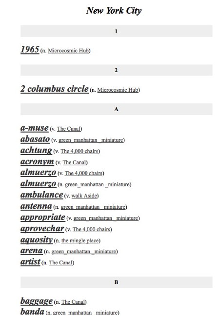
The term Periplum also suggests a mutually transformative relationship between language and the city. One of the projects I’ve always found fascinating is ABCDF: A Graphic Dictionary of Mexico City. The general principal of this book is to re-define the city through a new form of dictionary. Thousands of words are defined by images from a wide variety of sources, ranging from the home photographs of ordinary citizens, to historical newsprints, to the work of famous contemporary artists. These images are complimented by short texts in a glossary at the back. What emerges is a highly detailed mosaic of the city that brings to life the everyday life of the metropolis. With this background in mind, we designed Periplurban to function as an ever-expandable “dictionary.” The standard dictionary definition is an authoritative declaration of a word’s meaning. In this dictionary, the process of definition is made subjective and intermedia. Each participant is able to contribute words to the larger dictionary and define words through text, photography, video and maps. From a pedagogical perspective, what is attractive about this model of a media-based dictionary is the ability to bring together multiple perspectives into a cohesive project, without losing the specificity of individual work. It can also function cumulatively, so that each week students can complete small assignments that build up over time, and new students can pick up where previous groups have left off and continue to develop the project.
One of the challenges with the standard design studio is that it often starts from scratch and knowledge does not often transfer from one body of students to another. With Periplurban, we’re aiming to develop a system where different groups of students, sometimes at the same institution, sometimes at different institutions, can in effect collaborate together over many years by all contributing to the same constantly-evolving dictionary.
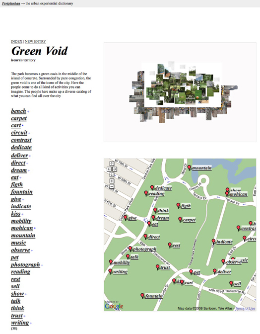
So much of architecture and urban planning today is developed while looking at a computer, whether through scripting and 3D modeling or researching sites through Google. We wanted to stimulate another mode of urban practice that was based fundamentally in the physical, social spaces of the city. In other words, we wanted to get students out of the classroom and onto the streets. We were inspired by Shklosvky’s concepts of estrangement and “Art as Technique”, we then aimed to use media arts critically as a mode of research to gain new perspectives. To begin, each student chose a specific site within New York City to declare as his or her territory for work over the whole course of the summer. The only constraint was that the space had to be traversable in 10 minutes by foot. As an initial act of linguistic reinterpretation, the students had to also name their territory. A student working in a section of Central Park named it “The Green Void.” Another student focusing upon the Columbus Circle area re-defined it as “The Microcosmic Hub.”
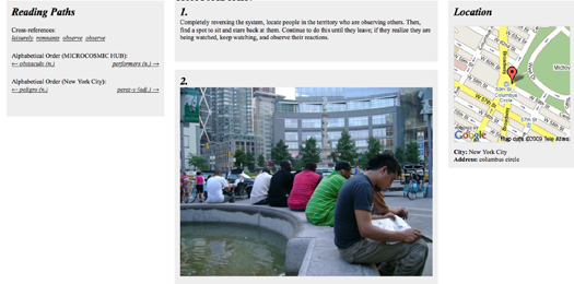
Students were assigned seven exercises ranging from ethnographic interviews to Fluxus-inspired non-theatrical performances to short city-symphony films. Some were representational, others were designed so that students had to create experiences for other people in their territory. The larger goal of these collective investigations was to begin re-defining what is a city, and in this process, to begin creating a new urban language. To complete the assignments, students had to define a minimum of five terms each week that resulted from their particular responses to the exercises. For example, after reading some excerpts from Kaprow’s Blurring of Art & Life, students were asked to write a series of instructions for people to perform while walking in the city. The student whose territory was “The Microcosmic Hub” invented the term “people-watch the people-watchers.” His definition was:
“completely reversing the system, locate people in the territory who are observing others. Then, find a spot to sit and stare back at them. Continue to do this until they leave; if they realize they are being watched, watch and observe their actions.”
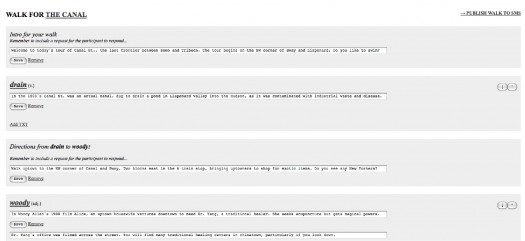
Though Periplurban accepts multiple media formats, we chose to make language the primary navigational interface. This shifts the focus to issues of subjective meaning, and produces tension and synergy on a linguistic level as the content grows, rather than the geospatial or media-type groupings that one might typically find with new media mapping projects. To foreground this dimension, we built in structures to cross-reference the definitions of each word. Basically, a student can create a link between any two definitions, producing paths through the work that might highlight surprising juxtapositions or suggest micro-narratives within the larger dictionary. For example, you can move from “acronym,” a verb directing people to write acronyms from their names using words found on Canal St, to “mosaic,” a verb directing people to look closely at a mosaic on Broadway near Columbia.
Furthering the language theme, we built on De Certeau’s understanding of walking through the city as an act of reading and writing. After each student defined around 35 words for their territory, the final assignment aimed to synthesize this material and create a series of design interventions in physical and virtual space. Writing in this new language, the core component of the students’ final project was to write a “poem” that linked together multiple words they had defined in their territory. In addition to the longer and visual media, students had to also now define their words in 140 characters as text messages. The poem would be read, then, as an SMS-based walking tour of their territory that poetically connects the words in physical space using the new vocabulary they have defined. We created the interface and the messaging infrastructure, which they could then script for their particular walks. The walks provided an experiential tour of the multiple layers of physical, social, historical and fictional qualities that students identified through their research throughout the summer.
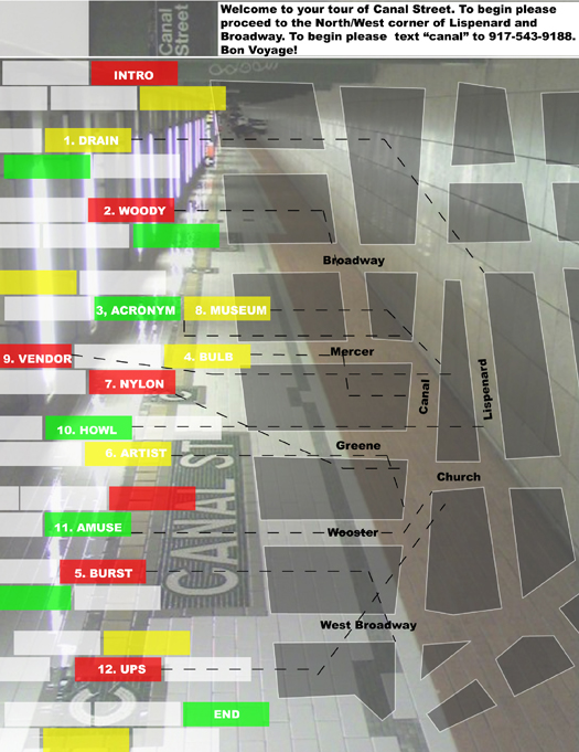
One of the most interesting walks was developed through “The Canal,” along Canal Street between Broadway and 6th Avenue. The student gave directions in terms of upstream and downstream according to the long-gone waterway, and folded the dictionary back into the street using her definitions such as “To Acronym (v.): To spell out one’s name using words that contain a letter in your name, found on Canal St. All words must be documented photographically.”
After a series of exercises (like bursting a bubble-blowers bubbles and feeling counterfeit bags), the walk leads into Pearl Paint to purchase drawing supplies. The participant is then asked to sit on a stoop and draw an impression of Canal Street and mail it to a friend at the historic post office building. What we really liked about this walk was the full engagement with the senses in such a personal way. It would have been impossible to convey the experience through documentation; the student’s script very effectively drew us into the space in a way that is now a persisting part of our perception of that space.
I think that maps are particularly problematic when they are viewed as closed works or interpreted as frozen representations. If we perceive them to be frameworks begging for subjective, human intervention, then maps suddenly become systems in need of constant individual and collective revision to give them meaning.
So really, there is nothing passive about applying one’s full creative capacity to the perception of the city. This isn’t a new ideal; the Situationist International suggested that the intersubjective reality of urban life might be transformed through a universal adoption of this kind of awareness. In 1967, Raoul Vaneigem wrote that “the concepts and abstractions which rule us have to be returned to their source, to lived experience… The sole authority is one’s own lived experience: and this everyone must prove to everyone else.”
Applied to urbanism, this becomes an imaginative practice, one that requires each of us to contribute to the re-creation of the city with every step.
Critical media arts must intervene in the sphere of the urban imaginary, “the cognitive and somatic image which we carry within us of the places where we live, work and play.” As Andreas Huyssen writes, the urban imaginary “is an embodied material fact. Urban imaginaries are thus part of any city’s reality rather than only figments of the imagination. What we think about a city and how we perceive it informs the ways we act in it.”
Technology is integral to this practice, but not as an end it itself. We should avoid making technology into a fetish. Instead, we might remember that the ways in which avant-garde artists first experimented with the new media of modernity, recognizing that each medium is a product, a construct, and a perception of its time.
Within the context of design education, Periplurban hopes to ignite a more serious conversation about the use of media in design practice. On one hand, we believe the project can evolve to become a more robust system for urban research and analysis. Design decisions are always influenced by the information that designers have at hand, and if a framework like Periplurban was deployed in a real design scenario, it would hopefully introduce a lot of surprising ideas and perspectives into the design process.
But possibly more importantly, we hope that it helps students to question the assumptions behind different media technologies and feel liberated to challenge these assumptions. As media become ever more integral to design and the urban experience, it becomes increasingly important to demystify media and empower designers and everyday citizens as critical media artists.
1. Yellow Arrow was created by Brian House, Jesse Shapins, Christopher Allen and Michael Counts in 2004 with the support of Counts Media Inc., a start-up entertainment company. The project culminated in 2006 and was archived in the public domain.
Some other urban locative media projects worth checking out include the following:
(list adapted from “Placelogging: mobile spatial annotation and its uses for urban planners and designers” by Raj Kottamasu)
Blockies (blockies.com)
Take pictures and place a special, printable sticker with a unique code at or near the site where the photo was taken. Send photos via MMS to the Blockies server with the unique code. Text messaging the server with the code returns the uploaded photo. Other participants can also upload more photos to the same unique code.
E-lens
Place and photograph stickers with unique mosaic visual codes to deliver and access place-based news, sports, weather and entertainment, to make reports or give input to civil authorities, to connect to social networks, or to engage in placelogging, collaborative art-making or gaming.
Geostickies (andrew.cmu.edu/user/noriyuki/artworks/geostickies/index.html)
Leave and read geo-located text messages about places using cell phones with installed location-based software. Receive alerts via phone when near posted messages.
Grafedia (grafedia.net)
Make real-world hyperlinks by uploading photos to keyword@grafedia.net via Media Message Service (MMS) and scrawling the underlined keyword in blue marker on any surface. Sending a text message or e-mail to that address returns the image.
[murmur] (murmurtoronto.ca)
Staff records stories about places from people who contact them or from people they find through community networks, makes them accessible via phone numbers and unique codes printed on green metal signs posted on telephone poles near sites.
Open City (terirueb.net/open)
Record messages, ambient sounds, conversations, stories or opinions about the present state of downtown Washington, D.C. via cell phone or public pay phone. Listen and contribute to recordings on the subjects of technology, public space and civic identity, also archived on project website.
Plazes
Add Flickr photos, comments and reviews to profiles of mapped locations; share personal real-time location and notes about those locations via Plazer application for PC or cell phone.
Semapedia
Create printable tags linked to Wikipedia (www.wikipedia.org) content with unique mosaic codes on them. Taking a picture of the barcode using cameraphones with 2D Barcode Reader applications installed calls up the Wikipedia page via mobile web.
SMS Guerrilla Projector (troika.uk.com/smsguerrillaprojector)
Project text based SMS messages onto public spaces, in streets, onto people, inside cinemas, shops, houses. A home made, fully operational device.
Socialight (socialight.com)
Map and share geo-tagged digital photoand text-based Sticky Notes via web or mobile. When mobile, get automatic alerts when near Sticky Notes from affiliated social networks and subscribed channels of content. Includes professionally authored content (reviews, attractions).
Tactical Sound Garden (tacticalsoundgarden.net)
Plant or remove sound files at specific locations using a WiFi enabled mobile device (PDA, laptop, cell phone). Drift through wireless “hot zones” listening to located recordings and songs with headphones and a WiFi enabled device.
TXTual Healing (txtualhealing.com)
Builds community through public story telling. TXTual Healing is an ongoing series of interactive performances that harnesses the SMS capabilities of the cell phone as a medium to interact with and explore our shared public and physical space.
Urban Markup (urbanmarkup.com)
Collect photographs and observations of urban markup language [i.e. – stickers, grafitti, maintenance and construction crew markings, etc.] found in New York City.
Urban Tapestries (urbantapestries.net)
Uses PDAs and cell phones to map and share ‘threads’ connecting sites of text, audio, video and photo annotations. Research project to explore social and cultural uses of the convergence of place and mobile technologies.
The views expressed here are those of the authors only and do not reflect the position of The Architectural League of New York.


Comments