
We are celebrating 15 years — and counting — of stories that are deeply researched and deeply felt, that build a historical record of what the city has been.
We are celebrating 15 years — and counting — of stories that are deeply researched and deeply felt, that build a historical record of what the city has been.

Three hypothetical fourty-four seater subway car layouts | Image via Transportation Research Board
SUBWAY MANEUVERS
A draft study produced by the MTA’s Transportation Research Board chronicles straphangers’ highly calculated positioning in subway cars to suggest new seat, pole, and door configurations for trains of the future. Drawn from observational studies over a three-week period in 2012, conclusions of the study included the tendency for riders to cluster near doors because of the many “partitions to lean against” and to save time exiting, and New Yorkers’ preference to stand instead of taking a seat between two occupied ones. The authors suggest staggering doors to better distribute passengers throughout the train and creating partions in the middle of benches to encourage riders to take a seat next to their fellow passengers.
HISTORIC BED-STUY
Following a vote by the Landmarks Preservation Commission, the Stuyvesant Heights Historic District in the Bedford-Stuyvesant neighborhood of Brooklyn is likely to triple in size when the City Council makes a final decision in about a month, 20 years after the move was first discussed. The proposed expansion would include over 800 brownstones, wood-frame houses, and Chateauesque apartment buildings in the historically African- and Caribbean-American community that is increasingly attracting significant outside real estate attention. The vote came in the context of the unclear fate of the nearby proposed Bedford Historic District, where some residents have raised concerns over the rising property values, regulatory burdens, and increased outside interest likely to accompany the designation.
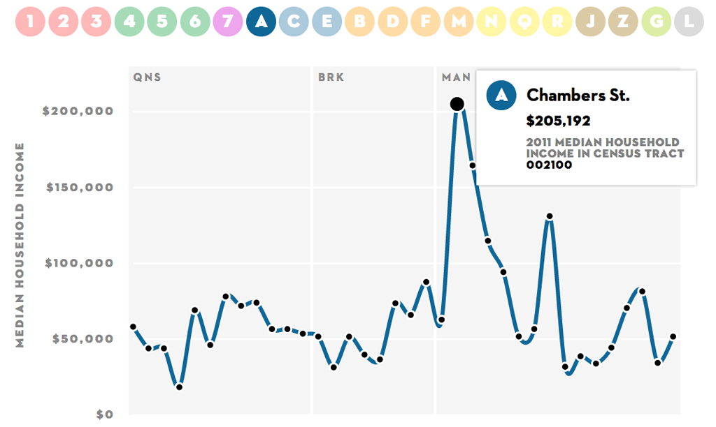
Screenshot of Inequity and New York’s Subway
TRANSIT ILLUSTRATES INEQUITY
Using data from the Census Bureaus’s 2011 American Community Survey, The New Yorker released an infographic displaying the remarkable range of incomes along subway lines, illustrating the city’s substantial income inequality. Benjamin Kabak at Second Ave. Sagas uses the visualization to call for New York to continue resisting zone-fared pricing, used in many cities to charge typically wealthier suburban transit users coming into the city center a higher fare than less wealthy inner city riders. New York City, Kabak argues, is unusual for an American city in that the wealthiest residents live in the most centralized neighborhoods, so a distance-based system would charge the highest fares to the least wealthy users.
FERRY FUTURES
As we continue our wait for the city’s next subway line, anticipate the rollout of Citi Bike, and temper our expectation of another tunnel across the Hudson, the future of another piece of the city’s transportation puzzle, ferry service, is less clear. On the heels of Sandy, in which ferries proved a resilient mode of travel in an otherwise severely crippled system, and the success of the East River Ferry, talk of a more robust ferry network is gaining momentum. Plans to expand ferry service on New York’s “blue highways” has started and stopped before, but Senator Chuck Schumer is calling for federal funding of additional East River Ferry stops and City Council Speaker and mayoral candidate Christine Quinn stated her support for subsidizing the ferry system as part of the city’s mass transit network. Pitched by advocates as a resilient option to better connect waterfront neighborhoods underserved by current transit options, with minimal capital costs to get up and running, we may see more water travel in the metro area that already has the highest ferry ridership of any in the nation.
NOISE MAPPED
Like architectural styles, demographics, and costs, the soundscape of the city differs from neighborhood to neighborhood. Using 311 data from 2012, designer Karl Sluis mapped Manhattan’s noise complaints to highlight the nodes of barking dogs, car stereos, parties, and construction — as well as the spaces of relative quiet — along the famously noisy island.
NYC, POWERED BY CANADA
New York State’s current aging electric lines lose a significant amount of power as they travel long distances, something new lines would help fix. On Thursday, state regulators approved a new power line that would increase the power to New York City by 10%, enough to power one million more homes, by traveling 330 miles from Canada to Queens under Lake Champlain and the Hudson River. Those opposed ask why we can’t produce more power (and create more jobs) further downstate and environmentalists have raised concerns over habitat destruction. The lines are slated to go online in 2018, but still need federal permits and private financing to move forward.
SANDY UPDATES
Making good on its pledge to not retreat from the waterfront following Sandy, the Bloomberg administration announced a design competition for Arverne East, a 40-block parcel of land along the beach in Far Rockaway, Queens, to be developed with low- and middle-income housing in addition to basic infrastructure like roads and sewers. The competition aims to develop prototypes for sustainable, affordable, and resilient shoreline development. Submissions are due June 14th. Finalists, who will be awarded $30,000 to further develop their ideas, will be chosen in July. Though there is no promise the designs will actually be built, the City hopes the competition will inform future development along its waterfronts and those of cities worldwide. This push stands in stark contrast to the idea of depopulating the coast line, a potentiality the US Army Corps of Engineers is in the midst of studying as it develops ideas for protecting the Northeast from future hurricanes. To build protection for this coastline, the State also announced the distribution of $645,000 to local groups in southern Queens to help rebuild 28 acres of salt marshes in Jamaica Bay, a piece of green infrastructure that would help protect neighborhoods from future storms.
EVENTS AND STUFF TO DO

Detail from the catalog for Another Chance for Housing: Low-Rise Alternatives, Museum of Modern Art, 1973 | Image via Karen Kubey
LOW RISE, HIGH DENSITY
Last year, Karen Kubey revisited Marcus Garvey Park Village in Brownsville, Brooklyn, in an Omnibus feature that revealed examples of the design philosophies and policy priorities behind low-rise, high-density housing. On Thursday, April 25th, at 6pm, an exhibition curated by Kubey that charts the evolution of this building type over the past 50 years, through drawings, photographs, and oral histories, will open at the Center for Architecture. Low Rise High Density will be on view through June 29th.
CLOSE UP AT A DISTANCE
Laura Kurgan of the Spatial Information Design Lab at Columbia will discuss her book Close Up at a Distance: Mapping, Technology, and Politics with artist and geographer Trevor Paglen on April 22nd at 6:30pm. The book covers Kurgan’s explorations of data-driven maps and satellite imagery as arguments, active interpretations, and propositions with important implications for humans rights and social justice.
CHANGING ARCHITECTURE
Also on April 22nd, at 6pm, Gluck+ will launch a new series examining how architects, through Architect Led Design Build (ALDB), can reengage in the production and development of the physical city. The event will feature a panel discussion with openhousenewyork, Janus Partners, and Pentagram and moderated by Metropolis Magazine Editor-in-Chief Susan Szenasy. The panel will be accompanied by videos of Architect Led Design Build projects.
The Roundup keeps you up to date with topics we’ve featured and other things we think are worth knowing about.
The views expressed here are those of the authors only and do not reflect the position of The Architectural League of New York.