
We are celebrating 15 years — and counting — of stories that are deeply researched and deeply felt, that build a historical record of what the city has been.
We are celebrating 15 years — and counting — of stories that are deeply researched and deeply felt, that build a historical record of what the city has been.
The Long Island Index is a project of the Rauch Foundation, a family foundation that invests in positive and transformative change in the communities of Long Island. For the past ten years, the Index has published reports on regional trends – such as housing, education, health, and jobs – and potential areas of strategic focus – such as scientific innovation, zoning regulations, and the role of the Long Island Rail Road (LIRR). In 2010, the Index invited June Williamson, professor of architecture at The City College of New York and co-author of Retrofitting Suburbia: Urban Design Solutions for Redesigning Suburbs, to conceive Build a Better Burb, a design competition that has since evolved into a robust, online resource of relevant international precedents in suburban housing design, transit planning, and regional planning.
In 2013, the Index published a report on the potential regional economic benefits of investment in improvements to the LIRR. The next step was to consider the possibilities for and impediments to growing the suburban downtowns that the LIRR connects. According to Index findings, much of the available land within a ½ mile of Long Island’s downtown centers is occupied by surface parking lots. Rethinking how parking structures could contribute to other planning priorities — developing more housing options, revitalizing main streets, and encouraging pedestrian activity — presented another opportunity for good design to be the mechanism to communicate the potential for change. Index Director Ann Golob invited Williamson back to consult, this time in partnership with Kaja Kühl, principal of youarethecity and adjunct professor of urban design at Columbia University, on the project that became ParkingPLUS.
Lots of available parking and car-dependency are among the most visible distinguishing characteristics of suburbs. But the suburban land allotted to parking just might provide the excess capacity needed to densify the suburbs in line with community goals — attracting young people, providing affordable housing, stimulating local economies — especially when its within striking distance of the rail system that weaves together New York City’s metropolitan region. In the article below, Kühl and Williamson explain how. —C.S.
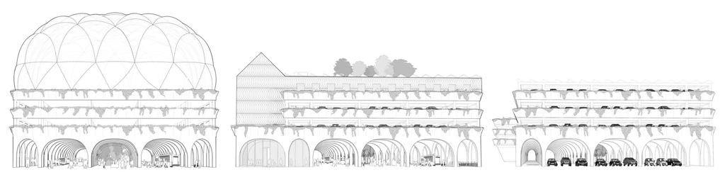
Parking deck prototypes in “Civic Arches” by Utile, Inc., proposed for Rockville Centre
Suburban Long Island is in many ways a pioneer for suburban development across the region and the nation. Home to the original Levittown, Long Island’s population growth in the second half of the 20th century is emblematic of the transformation of bounded cities into metropolitan regions, comprised of one or more large central cities at the core (New York, Newark) surrounded by a lower-density patchwork of residential and commercial sprawl.
However, like many other suburban communities in the New York metropolitan region (and the nation, for that matter), Long Island’s car-dependent mass suburbanization is preceded by a rich history of towns, hamlets, and villages along early railroads that connected New York to Boston (via ferry) and other cities along the eastern seaboard. The Long Island Rail Road (LIRR), begun in 1832, essentially reached its present-day extent in 1880. (The competing New Haven line, with superior overland connections to Boston, began running in 1850, requiring a retooling of the LIRR from a focus on regional to local commuter service.)
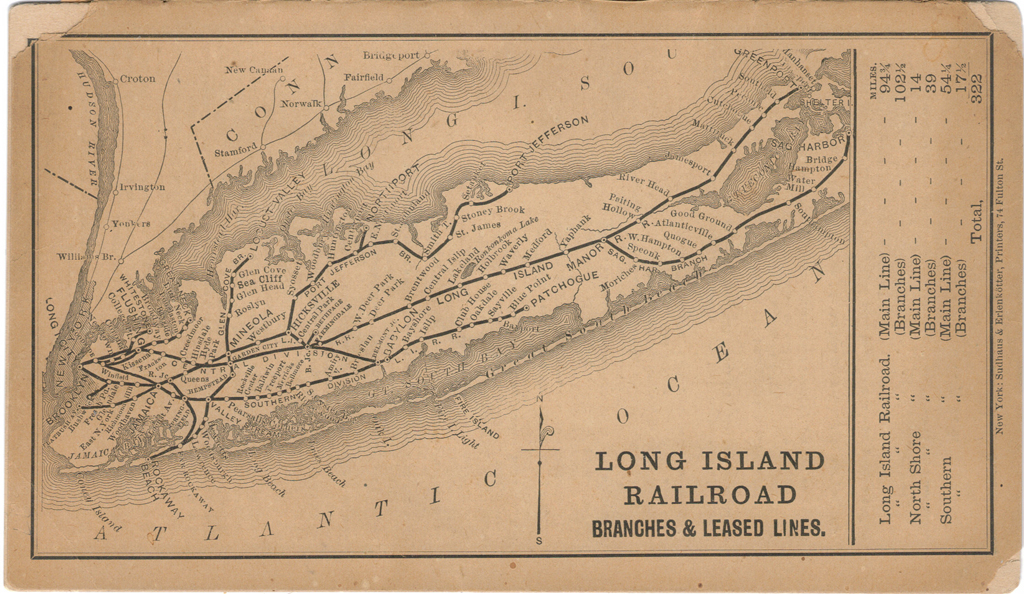
1878 map of the Long Island Railroad system | Image via LIRRHistory.com
Many Long Island communities had well-functioning centers with main streets, commercial corridors, town halls, village greens, and market squares at their heart. 20th-century development of parkways and Interstates as well as homeownership incentives through the Federal Housing Association (FHA) and the GI Bill changed these patterns, spurring a population increase from 950,000 in 1950 to 2.5 million in 1970. This profound growth was enabled by a program of highway construction that served to decentralize the populace into mass-market residential subdivisions and to concentrate commercial activity into the exciting (at the time) new building types of shopping malls and office parks. Main street businesses struggled to compete with the convenience of new malls, especially when potential shoppers from the new subdivisions couldn’t walk to either destination. And, instead of living in a village and walking to the nearest train station to go to the city, one drove to the station (if not making the entire commute by car).
Crucial to these developments were societal values and public policies that privileged individual mobility and car ownership. And as dependence on private cars for transportation grew, so did the need for storing them. Downtowns across the metropolitan region suffered a further loss in vitality and attractiveness as small businesses, houses, and civic institutions gave way to what is now — according to a study commissioned by the Long Island Index, a project of the Rauch Foundation — more than 4,000 acres of surface parking lots, along with 4,300 acres of vacant land, within a 10-minute walking radius of Long Island Rail Road stations and village downtowns.

8,300 acres of underutilized property in Long Island downtowns | Infographic via Long Island Index
And yet, the tide may be turning. There has been a groundswell of interest in revitalizing Long Island’s downtowns, fueled by the recognition that the two water-locked counties of Nassau and Suffolk (pop. 2.9 million) are otherwise “built out,” with no more room for new subdivisions and strip malls. Instead, the only room to grow — for more housing, economic development, and lifestyle improvements (walking, biking, streetlife, culture, historic preservation) — is inward, in the downtowns.
More efficient parking schemes are a vital key to unlocking land to help realize the potential of “incremental metropolitanism.” That is, the gradual retrofitting via redevelopment and re-inhabitation of a network of urban nodes and corridors within the suburbanized region, while regreening or conserving open space in between. Such a retrofitting would create capacity for new transit modes, with a mix of proximate uses, higher residential densities, and a greater range of housing types to choose from beyond the detached house. Increasingly, young professionals who were born and educated on Long Island leave for more affordable and diverse housing options and amenities found in the city or other suburban communities in New Jersey and Connecticut. Long Island lags significantly behind other suburban parts of the region in supplying rental units, especially in apartments and townhouses. The relative lack of housing choice impedes attracting workers and businesses, so the declining number of 25-34 year-olds impedes Long Island’s economic competitiveness with other parts of the metro region.

Comparison of Long Island with suburban neighbors | Infographic via Long Island Index
What to do to help further turn the tide? Our answer: the ParkingPLUS Design Challenge, an initiative to leverage the power of good design to engender a broad-based and constructive conversation to reset the terms of stymied debates about downtown redevelopment, transit, parking, and traffic in suburban villages. Oddly, the parking garage, a typology that doesn’t often make the architectural headlines — Miami Beach aside — seemed to be the key to push this conversation beyond how to store cars most efficiently. Better solutions to parking problems is what might succeed in getting people OUT of their cars and walking around in places already set up with transit connections. “Make them unlike any garages anyone has seen. Exciting, not drab. Multifunctional, not spaces that are empty nights and weekends. Engines for economic development, not just places to park,” suggested a Newsday editorial in support of the design challenge results, which were released in January 2014 at a launch event at Adelphi University.
Parking structures are a critical building type in efforts to reduce the carbon footprint of the automobile.For the past several years, the Long Island Index has commissioned research on trends in economy, population, housing, education, environment, open space, governance and health. The Index does not advocate specific policy; its mission is to catalyze action by gathering and publishing un-biased data on Nassau and Suffolk counties. The intent is to work outside the fray of the divisive, highly local politics characteristic of regions encumbered by fractured governance. The political discourse on Long Island, as in many suburbs, is dominated by an ethos of home rule which dictates that zoning, property taxes, and school jurisdictions are managed at the most local levels, complicating attempts to improve efficiency or equity. The legal implications of the home rule tradition can thwart comprehensive planning in many ways, as Gerald Frug explains, especially when bottom-up community initiatives don’t jive with localized power structures or when the absence of appropriately enabled regional bodies prevents region-wide coordination.
In 2013, the Index published a report that demonstrated the potential economic gains to the region from supporting new capital improvements to the LIRR. East Side Access, to be completed in 2019, will give LIRR riders direct access to Grand Central Terminal and east Midtown Manhattan. A second track from Farmingdale to Ronkonkoma would add capacity and reliability to one of the fastest growing yet most overcrowded commuter lines in the region. A third track on the 11-mile stretch of the Main Line from Floral Park to Hicksville (fiercely opposed by landowners along the route) would increase potential for reverse commuting.

Map of Long Island with sites of the ParkingPLUS Design Challenge
This year, the Index wished to follow up on past findings with a new design competition, this time concentrating on the opportunity to grow Long Island’s downtowns. Since parking — the perceived lack of it and the land it consumes — is one impediment to tapping downtowns as a regional asset, downtown surface parking lots became the focus.
The Index engaged us to craft the new competition. We called it ParkingPLUS – the “plus” added to signal that we wanted designs to transcend the program of a feasible parking structure by suggesting collateral uses and benefits. Also, the designs should both fit the specific requirements and needs of the site and perform as prototypes that could be applied and imagined in any of dozens of downtown parking lot sites with similar opportunities.
As we wrote in the design brief:
“Structured parking facilities are generally thought of as being single-purpose, stand-alone structures that are ugly, unsafe, and out of place in our downtowns. Designers are encouraged to expand the concept of ‘parking’ beyond standard practice and to demonstrate how these structures can be architecturally innovative while anchoring creative strategies for downtown parking. … The core of this challenge is to demonstrate how such structures, when exceptionally well designed and featuring innovative architectural, technical, operational, and financing strategies, and when part of a large strategy for managing downtown parking and mobility, could be potentially transformative to their suburban downtown settings.”
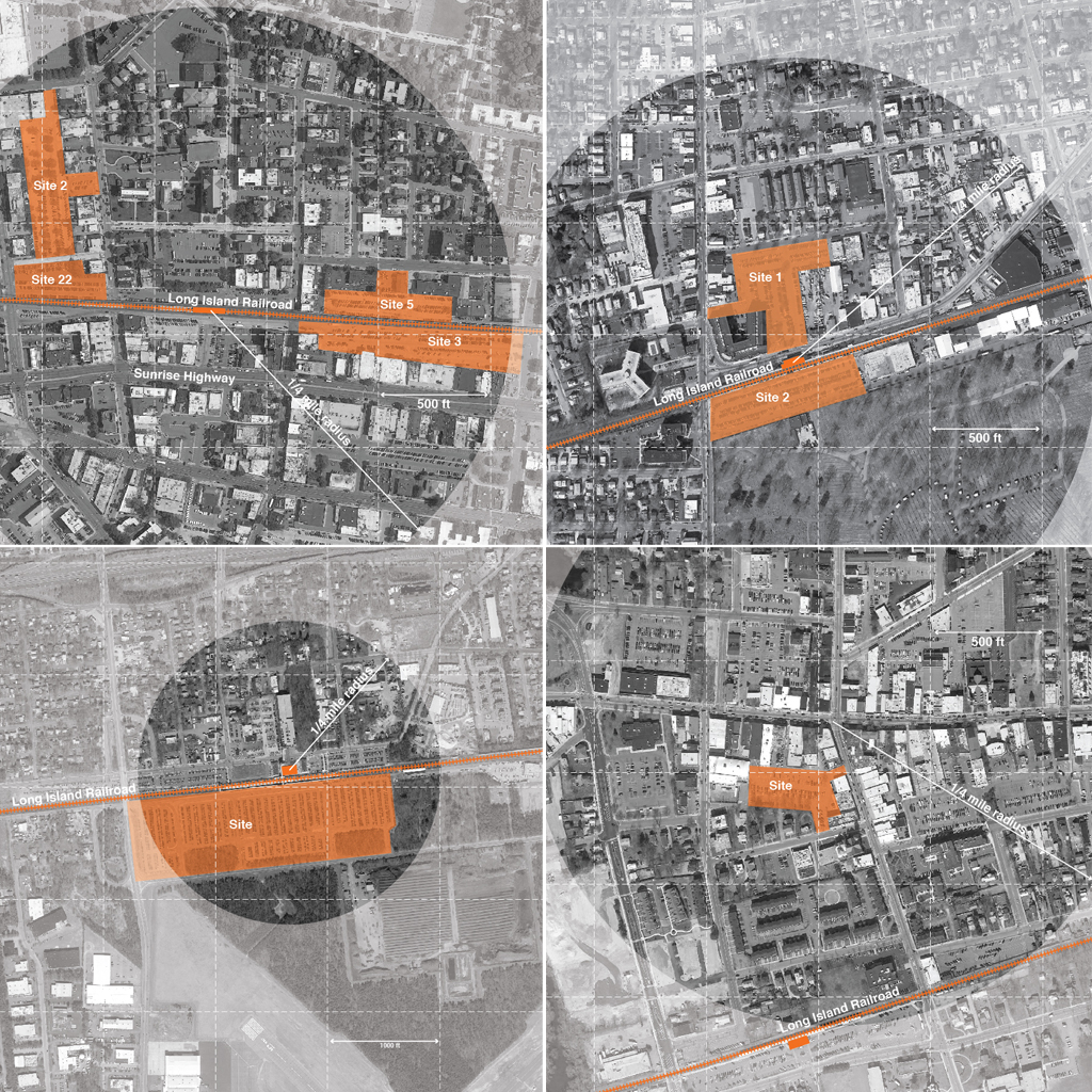
The sites for the ParkingPLUS competition, clockwise from top: Rockville Centre, Westbury, Patchogue, and Ronkonkoma
Each site — located in the villages of Rockville Centre, Westbury, and Patchogue, and on the 30-acre surface commuter lot south of the busy Ronkonkoma LIRR station — was matched with a design team selected from a diverse list of practices, each with established track records in creative suburban design, that had responded to the initial request for qualifications.

“Civic Arches” by Utile, Inc., proposed for Rockville Centre
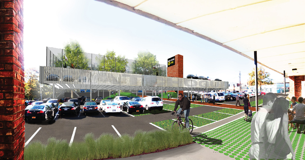
For Rockville Centre, Boston-based Utile, Inc. have designed a garage prototype with a ground floor of soaring, monumental, concrete arches, that is both inspiring and economical to construct. If built, three variations of the prototype design would free up more than three and a half acres of land for small parks and plazas connecting to an existing network of parks that could support biking, while at the same time adding more than 400 parking spaces to Rockville Centre’s supply. The design also demonstrates a plug-and-play concept for additional uses, from housing to tennis courts. Most distinctive, however, is the design for the flexible use of the ground floor. It allows for other uses to take over the space on weekends and evenings for markets or festivals, when the need for commuter parking space is less.
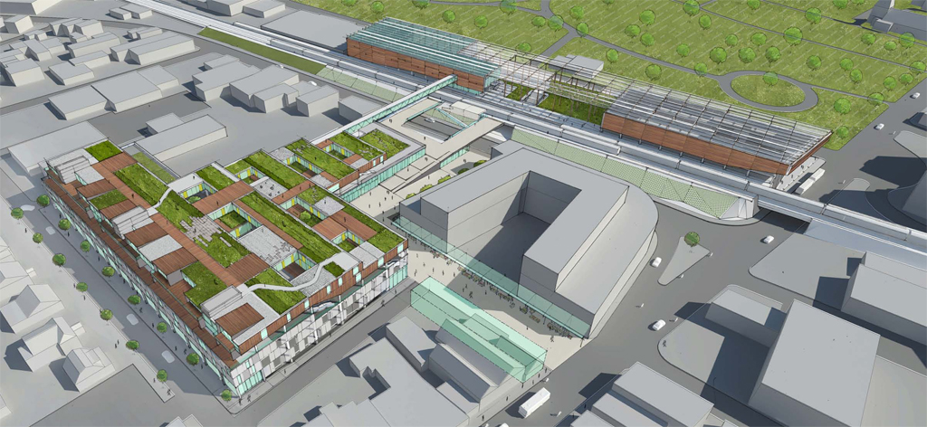
“Train Terraces” by LTL Architects, proposed for Westbury
In Westbury, LTL Architects propose two prototypes for integrating new commuter parking into mixed-used development. For one site, owned by the Village of Westbury, parking is sandwiched into a residential building with terraced apartments above ground floor retail. For a second site, owned by the LIRR, parking is mixed with commercial incubator spaces and station uses and includes a public plaza at the level of the elevated rail as an extension of the platform. The designs respond to trends identified by the Long Island Index, namely the need for diverse housing types to accommodate different age and income groups as well as flexible, non-9-to-5 workspaces that can facilitate innovation and entrepreneurship.
“Brackets” by dub studios, proposed for Patchogue
The Village of Patchogue has recently experienced success in revitalizing its Main Street with a renovated historic theater, bars and restaurants, new apartments, and a burgeoning art scene, expanding the perceived need for parking. The current supply in 13 municipally-owned surface parking lots is all hidden in mid-block locations. Michael Piper and his team from dub studios propose both a modestly sized new parking deck and a way-finding system of automated signage, lighting, and landscape improvements that would promote better usage of current parking. Knowing where to find a parking spot can save motorists the equivalent of 150,000 miles annually driving around searching for parking.
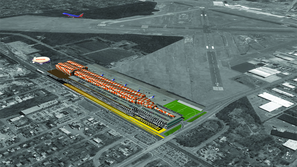
“Parks & Rides” by Roger Sherman Architecture and Urban Design, proposed for Ronkonkoma
Lastly, the 30-acre parking lot in Ronkonkoma, serving a major LIRR station and near MacArthur Airport, is an interesting outlier in this set of “typical” parking lots. Roger Sherman Architecture and Urban Design’s Los Angeles-based team took on the challenge of an open site with a convergence of several different transit modes: rail, air, car, and truck. They propose a super-scaled, family-focused, all-season recreational park in the form of a (tongue-in-cheek) tipped-over Empire State Building, with alternating levels of parking and other uses. The design combines a large amount of commuter parking with other uses that fill the same spaces during off-peak hours. It also introduces the notion of reduced future need for conventional parking by anticipating the adoption of smaller Non-Emission Vehicles (NEVs).
Will these parking structures be built? All of these designs were speculative in nature, but based on real needs and stakeholder input in the four communities. Designers were asked to straddle between site-specificity and thinking in terms of prototype. The participating villages and county planners have expressed interest in continuing the conversation, and the designs generated by this challenge will help them articulate needs, weigh pros and cons, and understand costs and benefits. The Long Island Index was particularly interested in supporting a conversation around the latter and hired parking consultant Gerry Giosa of Level G Associates to investigate the long-term economic benefits for each proposal. Parking structures cost money and are certainly more expensive to build and maintain than surface parking lots. However, taking a long and interdisciplinary view can help overcome financing obstacles and skepticism.
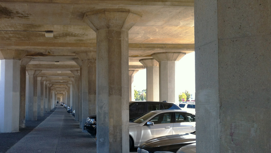
Under the LIRR tracks in Rockville Centre
Rockville Centre, for instance, is genuinely interested in partnering with the LIRR to build a parking structure in order to expand its capacity for commuter parking. Patchogue has already undertaken measures to optimize its existing parking, and village leaders see the scale and site selection of dub studios’ proposal as a further step in the right direction.
The designs were also sponsored to fuel a different and more general conversation about suburban downtowns and how they use valuable sites near train stations and main streets. The need for cars to travel the last mile (or more likely the last five to ten miles) will persist in suburbs for some time. Therefore, the designs — intended for rail commuters on the busiest commuter railroad in the country — beg the question: How can we be smarter about the “mode-shift” from car to rail? How can we make some of the most passed-through places in our suburbs more attractive and useful for suburbanites? Several of the designs confront the current inefficiencies of “trip-chaining.” On the way from rail station to home you stop by your child’s school, your dry cleaner, your pharmacist, and your grocery store. What if you could do all these things within a five-minute walking radius before you get into your car?
So in a surprising way, parking structures are a critical building type in efforts to enable mobility in suburbs while at the same time reducing the carbon footprint of auto use and ultimately the need for many of the trips for which suburbanites currently depend upon cars.
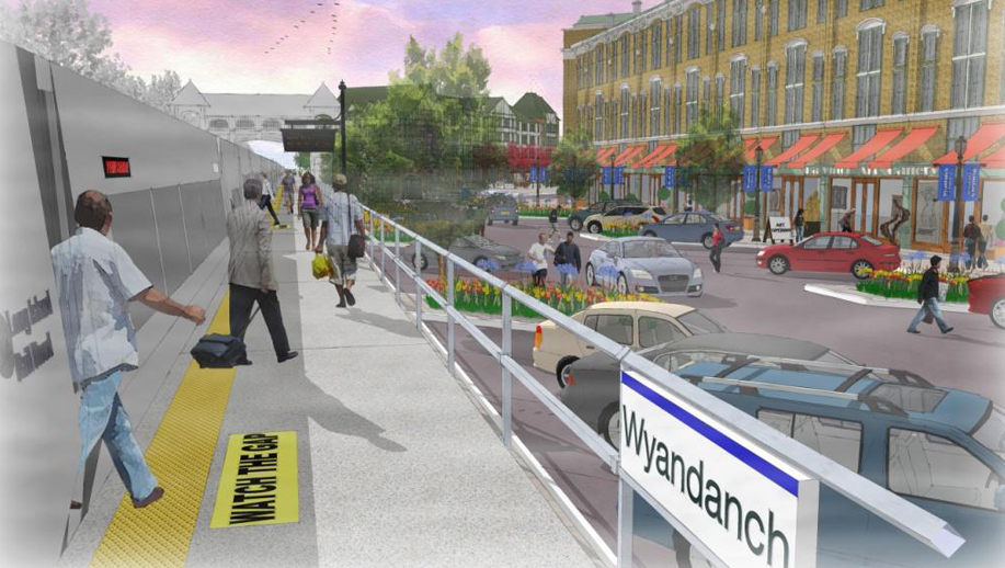
A vision for transit-oriented development in Wyandanch | Image via Steve Bellone
Obviously, ParkingPLUS is far from the only suburban retrofitting initiative underway in Metro New York. Wyandanch Rising is an ambitious $500 million downtown rebuilding initiative in a hamlet in the Suffolk County town of Babylon, home to a population, 65% black and 28% Hispanic or Latino, whose needs have been overlooked for decades. A rebuilt LIRR station — with ample structured parking — will be the anchor. Giosa cites the example of Morristown, NJ, where $26 million in downtown public parking structure investments in the 2000s catalyzed $185 million in new nearby private development. Also in New Jersey, the 21-mile Hudson-Bergen Light Rail has been a game changer, and plans are underway to extend a northern branch from North Bergen to Englewood. In Westchester County, rebuilding of the Tappan Zee Bridge may support new mass transit along the east-west I-287 corridor from Tarrytown to Port Chester, supporting initiatives for new multi-unit housing. County planners commissioned a study into the potential for new “workforce” housing on excess surface parking lots in aging office parks, although it seems to have been shelved.
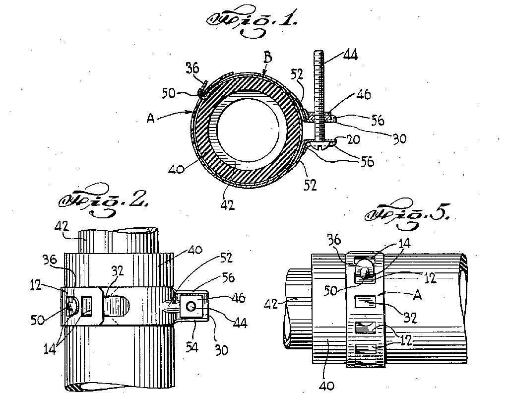
1938 patent modification of the worm drive hose clamp by Philip Rauch Sr.’s sons, Louis J. Rauch and Philip Rauch
A delicious and appropriate irony is that the Rauch Foundation’s patriarch, Philip Rauch, Sr., a German immigrant to Brooklyn, invented and patented the worm drive hose clamp, a tiny but vital automotive part. The company he founded, under the stewardship of his family, became very successful.
It is an equally challenging task — though probably not patentable — to design the key parts that might make suburban downtown retrofitting engines purr more smoothly.
The paragraph on Philip Rauch, Sr. has been changed to correct a factual error. Unless otherwise noted, all images courtesy of ParkingPLUS.
The views expressed here are those of the authors only and do not reflect the position of The Architectural League of New York.