
We are celebrating 15 years — and counting — of stories that are deeply researched and deeply felt, that build a historical record of what the city has been.
We are celebrating 15 years — and counting — of stories that are deeply researched and deeply felt, that build a historical record of what the city has been.
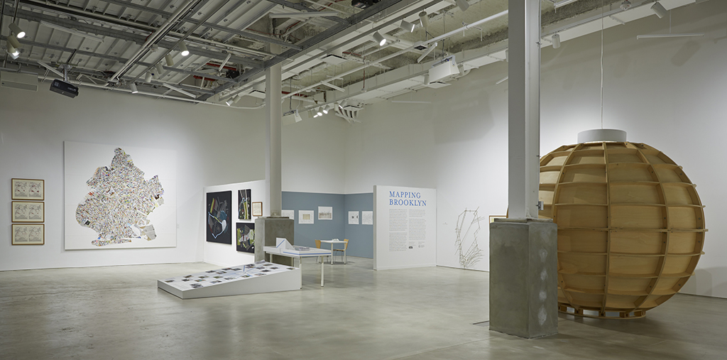
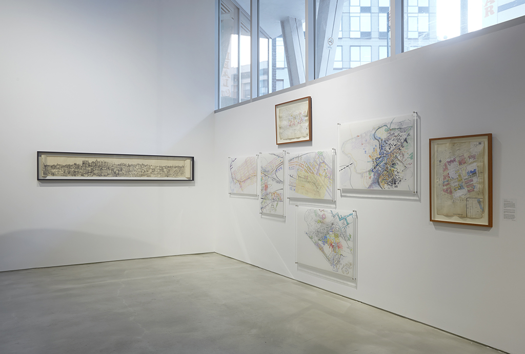
Mapping Brooklyn at BRIC | Photo by Jason Wyche, courtesy of BRIC
Dutch tradesman Jasper Danckaerts, sailing under the alias Schilders, arrived in New York from Amsterdam in 1679. He was on a mission to secure a safe settlement abroad for Protestant Labadists, but upon arrival Danckaerts began documenting a region still navigating the transition from Dutch to British rule put in motion a decade earlier.
In one remarkable entry from his diary, a collection of drawings and writings on colonial and native settlements, Danckaerts documented his attempt to convert an Algonquian man to Christianity. The indigenous man responded with a drawing on the floor:
He first drew a circle, a little oval, to which he made four paws or feet, a head and a tail. “This,” said he, “is a tortoise, lying in the water around it,” and he moved his hand round the figure, continuing, “This was or is all water, and so at first was the world or the earth, when the tortoise gradually raised its round back up high, and the water ran off it, and thus the earth became dry.” He then took a little straw and placed it on end in the middle of the figure, and proceeded, “The earth was now dry, and there grew a tree in the middle of the earth, and the root of this tree sent forth a sprout beside it and there grew upon it a man, who was the first male. This man was then alone, and would have remained there; but the tree bent over until its top touched the earth, and there shot therein another root, from which came forth another sprout, and there grew upon it the woman, and from these two are all men produced.”
Maneto, the spirit that calls the tortoise to raise its back, inspires a markedly different spiritual map from Danckaerts’ Christian compass.
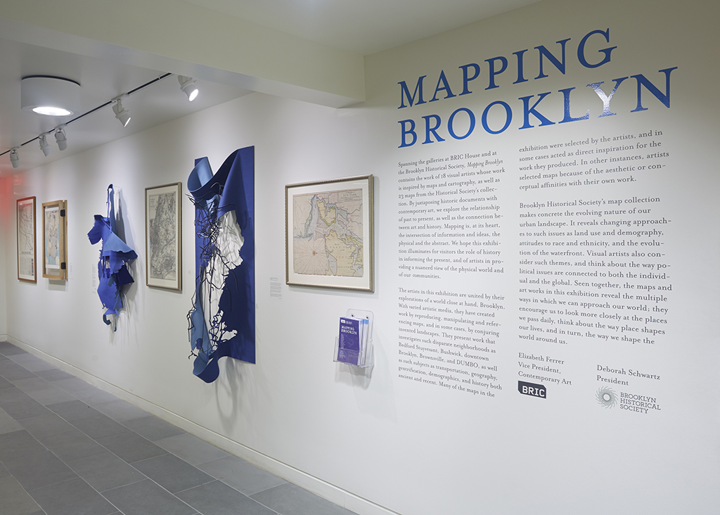
Mapping Brooklyn at the Brooklyn Historical Society | Photo by Jason Wyche, courtesy of BRIC
Danckaerts’ diary is an example of how vital visualization is to the making and making sense of place. Giving order to landscapes is a creative task, open to many interpretations and uncertainties. So too is the process of representing these relationships on the (printed or virtual) page, an endeavor that Danckaerts and his indigenous companion acted out through constant negotiation.
This lively effort — mapping — is the subject of a rich exhibition organized by the Brooklyn Historical Society (BHS) and BRIC (and spread across each institution’s galleries) that pairs the work of 18 contemporary artists with 23 historical maps dating back as far as 1562. For Mapping Brooklyn, BHS opened its collection to the invited artists, who selected historical images that complement or inspire their works. The goal of uniting these two components — map and art — is to uncover the common ground: to render, through judgment and artistic process, the world legible.
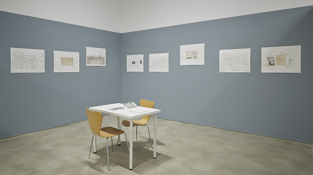
Drawings from Jan Rothuizen’s Brooklyn Journals: The Distance from a point to a line in time | Photo by Jason Wyche, courtesy of BRIC
Among the historical elements on view in the exhibition are excerpts from Danckaerts’ diary, which are surprisingly bizarre given the typical daily scenes they portray. The sketches show an intense focus on objects and people, so much so that these features stand out from the worlds they inhabit. The images — notably similar in effect to the cosmogram of Maneto — reveal a mind that is keen to categorize. Fish, boats, hills, and docks form an index of symbols that Danckaerts assembles and reassembles in a colonial jenga.
Jan Rothuizen, a Dutch artist, picks up on the constant dance of this indexical approach in a series of illustrations based on Danckaerts’ diary. Rothuizen plays the role of voyeur, archeologist, and anthropologist in his drawings of rooms, subway cars, and vistas, the records of his 21st century wanderings through New York City. Text and empty space interspersed through the landscapes recall doodles or the directionless psychogeographies of the flâneur and Situationists. In one image, clouds from a Danckaerts drawing extend into flight lines above a distant Newark airport. These lines lead to the note, “THERE IS A SMALL HOLE IN THE PAPER,” written where a tack once held the faded page. In another frame, Rothuizen draws a cluttered kitchen in Bed Stuy. “BAKING COOKIES IS MEDITATION,” he writes, each sentence linked to the next by a line “— Luis says he learned much of the HIPPIES — I am also a non-violent person. I liked GAY PEOPLE before it was legal to like them.”
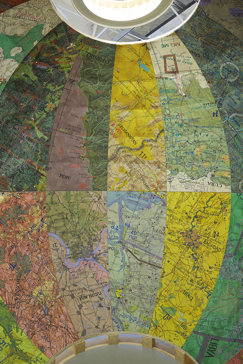
Inside Joyce Kozloff’s Targets | Photo by Jason Wyche, courtesy of BRIC
Citing aerial maps as inspiration, Joyce Kozloff shares Rothuizen’s interest in using mapping precedents to tease out underlying stories about place. But for Kozloff the goal is explicitly political. At BRIC she installs a walk-in globe turned outside in, the interior paneled with painted details from geographic surveys. This checkerboard of maps follows no cardinal direction; the orienting point is a large disk that casts a nearly shadow-less light from above. Compressed, echoing, and disorienting, the interior hardly offers the stabilized worldview that we expect from maps. Only when I discovered that the maps locate 24 raids carried out by the United States Air Force from 1945 to 2000 did I realize that the globe resembles a bomb.
The exhibition makes a clear distinction between maps and the art on display: while the historical maps function as cartographic records, the art celebrates mapping’s potential for interpretation and critique. The form of the map — its power as a symbol — becomes the point of entry for the artists’ work, as seen in Kozloff’s metaphorical globe. This extends to Christine Gedeon’s stitched abstractions of transportation lines and urban grids, Gail Biederman’s collapsed topographical felt forms, Nick Vaughan and Jake Margolin’s road map-turned-silhouette of two men kissing, and Daniel Bejar’s empty subway map of Manhattan pre-colonization, titled Get Lost! (NYC). What maps articulate as symbols — power, ownership, security, fear, nostalgia, etcetera — is often the subject of the artists’ work rather than the techniques that drive the mapping process.
Simonetta Moro’s pieces from left, A Room With a View: The Last of Bed Stuy and Crossing Prospect Expressway. An original Sanborn Map is installed to the right. | Photo by Jason Wyche, courtesy of BRIC
Simonetta Moro’s contribution demonstrates this preference for conceiving mapping as a style or form. Moro’s exquisite drawings offer thrilling counterpoints to historical Sanborn Maps, once used by insurance companies and City agencies to assess fire risk. As cityscapes changed, the maps were redrawn with pieces of paper pasted onto the original image. Moro’s streetscapes recall the Sanborn pasting technique: in Crossing Prospect Expressway, Moro traces walkways, urban developments, and other sites on sheets of Mylar that stack to produce strikingly colorful compositions. Here, layering becomes an exercise or metaphor rather than an operative tool; it is unclear what Moro uncovers apart from an impression of place.
There are, however, exceptions to the map-art divide. Laura Kurgan’s influential 2005 project Million Dollar Blocks works with data to reshape attitudes toward place and its people. The project locates the residential addresses of incarcerated individuals, a simple but powerful reversal of traditional practices that plot where crime occurs. The result is a startling insight into the effects of mass incarceration on neighborhood blocks, where in some cases the government pays over $1 million a year to hold residents in prison — money that, Kurgan implies, would be better invested in social services in those neighborhoods.
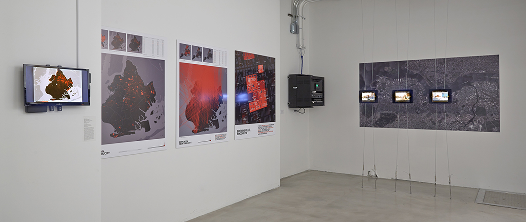
Laura Kurgan’s Million Dollar Blocks | Photo by Jason Wyche, courtesy of BRIC
In their exhibition statements, BRIC’s Elizabeth Ferrer and BHS’s Deborah Schwartz outline the benefits of inviting contemporary artists to engage a historical collection: while BHS presents an “incredible range of work in the long-established field of cartography,” the artists conceptualize the older work and uncover “a means of interpreting a world close at hand.” This statement suggests a duality within mapping, with “the multitude of ways that maps can represent, on the one hand, such practical matters of wayfinding, property ownership, population shifts, and war strategy, and on the other, the terrain of the metaphorical, psychological, and personal.”
Although art historians, artists, and cartographers now call attention to the erosion of these distinctions, Mapping Brooklyn is too hesitant in creating evidence for it. Patricia Smith’s surreal emotional landscapes of mourning and memory hang without historical precedence or comparison, as if the past has nothing to share on such intimate subjects.

Patricia Smith’s All-Purpose Mourning Stadium and Upper Brooklyn Recovered Memory Tureen, to the left of Jan Rothuizen’s drawings | Photo by Jason Wyche, courtesy of BRIC
Ferrer writes that mapping is “an enduring theme in great art because of its utter flexibility as a visual signifier.” However, to borrow from landscape architect James Corner’s essay “The Agency of Mapping: Speculation, Critique and Invention,” this line of thought stops short of acknowledging that geography itself is not “access to reality.” Landscapes are dynamic processes; images of territory might not be adequate depictions of the forces and realities on the ground. Drawing from Baudrillard, Deleuze, Derrida, and others, Corner argues that mapping is a “doubly projective” maneuver that first abstracts landscapes into the mind and then translates them back to the page. Perception of place inspires behavior, which in turn sculpts the real ground on which we stand. It is the coloring and forming of “the grounded individual” and her sense of the world that are the map’s meat and the artist’s arena. The connection between how we see and how we act is why mapping endures in and as art.

Nuremberg Map of Tenochtitlan | Image via Wikimedia Commons
The Nuremberg Map of Tenochtitlan (1524), Giambattista Nolli’s figure ground map of Rome (1748), Buckminster Fuller’s Dymaxion Map (1954), and Haitian voodoo’s cosmological vévés demonstrate how maps can retain functional — though not necessarily cartographic — purpose without losing the capacity to bewilder, incite, and connect new territories — real, imagined, or felt. Although historical, their thoughtful construction and innovative techniques grant them agency and voice in today’s world. Historical images can recast the world anew, and art can apply process to more than just form.
In 1680, Danckaerts left New York for the Chesapeake Bay to establish his Labadist community. Today, all physical traces of this Protestant sect and its way of life are lost. What remains are maps and writings, traces of a distant moment set deep in the foundation of the Americas. These colonial drawings and their stories of native spirits like Maneto are odd but somehow familiar to my eyes. Soon, too, will appear today’s guides.
Mapping Brooklyn is on view at BRIC through May 3rd and at the Brooklyn Historical Society through September 6th.
The views expressed here are those of the authors only and do not reflect the position of The Architectural League of New York.
Comments