Revisiting Freshkills’ West Mound

Completion of the Freshkills Park Project is still two decades out, but changes, however small, are all around. Brown grasses turn green, covering the once-bare sides of the site’s four mounds. Ultimately, the transformation here will be dramatic and fundamental: Before it opens as the second largest public park in New York City, this former landfill — approximately 150 million accumulated tons of solid waste — must be capped and covered with layers of plastic, soil, rocks, and finally, plants. Over the last year, Urban Omnibus, in collaboration with the Freshkills Park Development Team, has been documenting the site’s evolution through a series of photo essays. Two of the mounds, North Mound and East Mound, have been capped but not yet turned into parkland, and normally closed, and will be open to the public for one day only, on June 26. For this photo essay installment, photographers return to West Mound, the setting of the second installment and the highest point in the park-to-be, to take note of what has changed and what remains the same. –O.S.

Textures carved by the weather into the top soil layer of West Mound. | Photo by <a href="http://www.michaelmcweeney.com/">Michael McWeeney</a> courtesy of the City of New York: NYC Parks, Freshkills Park, and the Department of Sanitation
Textures carved by the weather into the top soil layer of West Mound. | Photo by Michael McWeeney courtesy of the City of New York: NYC Parks, Freshkills Park, and the Department of Sanitation

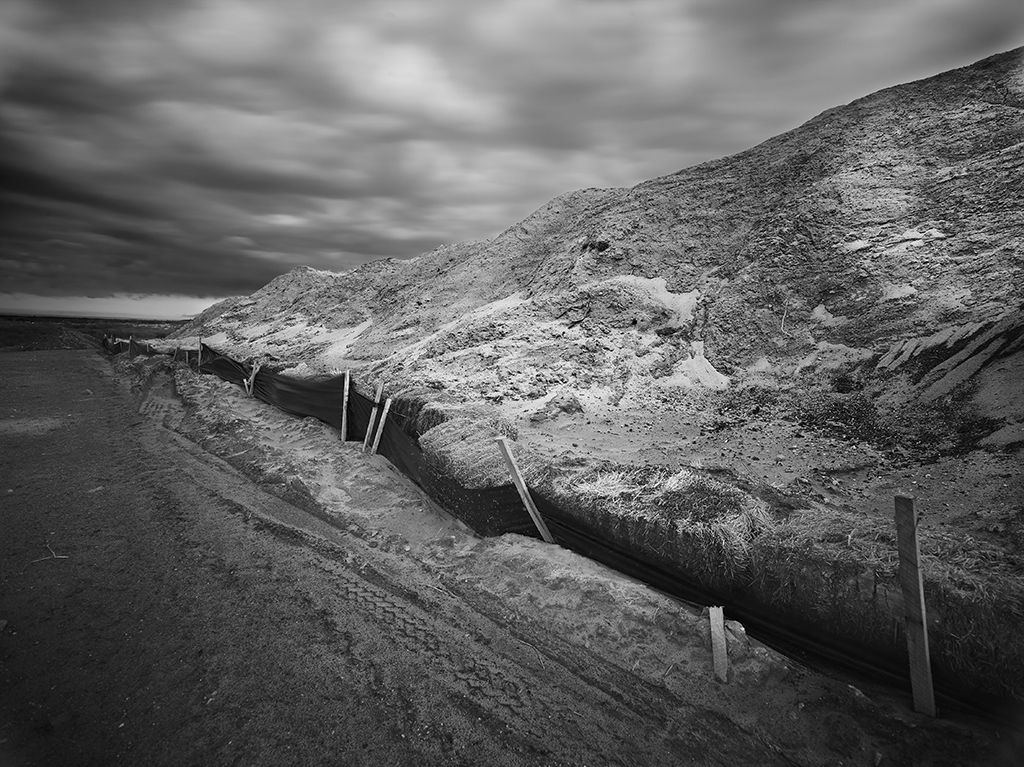
We return to West Mound, where landfill cap construction is well underway. Landfill caps on South and North Mounds were complete in 1996 and 1997, then East Mound in 2011. Those areas have become rolling, grassy hills, while West Mound evolves in a spectrum of colors and surface textures. For the next few years, contractors will continue laying down at least six feet of barrier material and infrastructure, layer by layer, in sections across the 545 acres of West Mound.

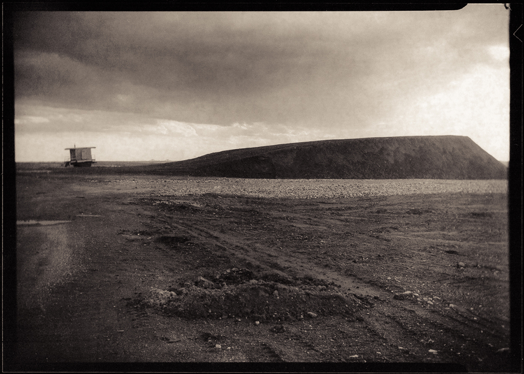
Rising up from the 2,200-acre Freshkills site and presiding over the Arthur Kill waterway, West Mound cuts a dramatic 200 foot-figure. April 4th’s forecast was uncertain and by the time we went out at golden hour, it was as if the peak of the mound was situated between sun and stormy weather. Photographers captured the threshold between sun and rain, between day and night, between landfill and park.

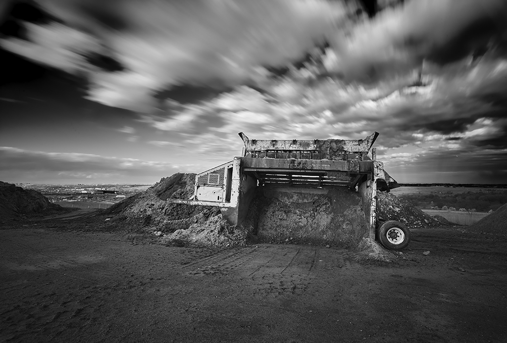
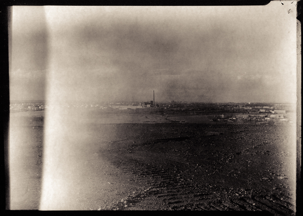
There is implicit movement in these photographs, though construction machines stand unusually still on a Saturday evening. Michael McWeeney documents the machines, wedged into capping soils and frozen in time while clouds whiz by overhead. Reminiscent of Ed Ruscha’s photographs of vacant gas stations and industrial sites along the Pacific Coast Highway, Michael Falco’s pinhole photographs suggest that we, the viewers, are moving quickly past piles of barrier material, like travelers on the West Shore Expressway below.

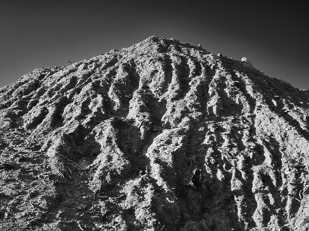
On the weekdays, trucks cart soil into the site like a conveyer belt. Though they are nowhere to be seen on the weekends, the marks of their tire treads remain, the movement imprinted on the top layer of soil. Nadège Giraudet depicts the tracks in the land as a textile, weaving in a crisscross pattern up to the horizon. Meanwhile, Charles Giraudet seems to have traveled back in time to the days before the landfill, shooting this entirely engineered landscape with a camera from 1895. The leaking light adds an ethereal quality to his photographs’ sepia tones.

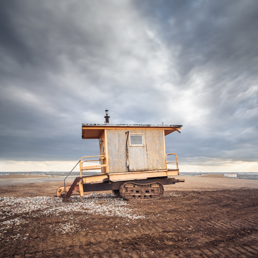
We then dip down to the so-called Boat Graveyard at the southwestern edge of the site, in the Arthur Kill. A view of the mound’s side suggests the constructed topography and the wild trees that have grown of their own volition, swept by the winds coming off the waterway. The half-sunken, dilapidated boats in the Kill and the warming hut at the peak of the mound are monuments to human impacts on this area, and to the massive effort to alleviate those harms and cultivate a fresh start. Will Ellis frames the warming hut as almost a toy figure, juxtaposing the vastness of the view with tangible details. These photos return us once more to the iterative industrial history of Staten Island’s west shore, and its transformation.

Michael McWeeney

The surface of the mound is peppered with machines, usually hard at work covering the solid waste with layers of soil, gravel, and plastic. | Photo by <a href="http://www.michaelmcweeney.com/">Michael McWeeney</a> courtesy of the City of New York: NYC Parks, Freshkills Park, and the Department of Sanitation
The surface of the mound is peppered with machines, usually hard at work covering the solid waste with layers of soil, gravel, and plastic. | Photo by Michael McWeeney courtesy of the City of New York: NYC Parks, Freshkills Park, and the Department of Sanitation
A pile of barrier material that will be distributed over the mound as part of the multi-layer landfill cap. | Photo by <a href="http://www.michaelmcweeney.com/">Michael McWeeney</a> courtesy of the City of New York: NYC Parks, Freshkills Park, and the Department of Sanitation
A pile of barrier material that will be distributed over the mound as part of the multi-layer landfill cap. | Photo by Michael McWeeney courtesy of the City of New York: NYC Parks, Freshkills Park, and the Department of Sanitation

Michael Falco

Falco’s pinhole camera uses a long exposure, 4X5 sheet film, and no lens or mirror, producing a soft-focus photograph. Here, the small-rock gravel that forms the drainage layer can be seen in the foreground. | Photo by <a href="http://www.falcophoto.com/editorial/photos-pi_4.html">Michael Falco</a> courtesy of the City of New York: NYC Parks, Freshkills Park, and the Department of Sanitation
Falco’s pinhole camera uses a long exposure, 4X5 sheet film, and no lens or mirror, producing a soft-focus photograph. Here, the small-rock gravel that forms the drainage layer can be seen in the foreground. | Photo by Michael Falco courtesy of the City of New York: NYC Parks, Freshkills Park, and the Department of Sanitation
The pinhole captures the profile of the mound, the soil layer, and the rushing clouds. | Photo by <a href="http://www.falcophoto.com/editorial/photos-pi_4.html">Michael Falco</a> courtesy of the City of New York: NYC Parks, Freshkills Park, and the Department of Sanitation
The pinhole captures the profile of the mound, the soil layer, and the rushing clouds. | Photo by Michael Falco courtesy of the City of New York: NYC Parks, Freshkills Park, and the Department of Sanitation

Nadège Giraudet

The tire treads on the surface of the mound, and park vans and concrete barriers in the distance. | Photo by Nadège Giraudet courtesy of the City of New York: NYC Parks, Freshkills Park, and the Department of Sanitation
Windswept trees on the slope down to the Arthur Kill foreshadow the vegetation that will eventually cover this area of the park. | Photo by Nadège Giraudet courtesy of the City of New York: NYC Parks, Freshkills Park, and the Department of Sanitation

Charles Giraudet

The warming hut and the crest of a tall pile of soil to be distributed as part of the landfill cap layers, captured by a 120-year-old camera. | Photo by <a href="http://charlesgiraudet.com/">Charles Giraudet</a> courtesy of the City of New York: NYC Parks, Freshkills Park, and the Department of Sanitation
The warming hut and the crest of a tall pile of soil to be distributed as part of the landfill cap layers, captured by a 120-year-old camera. | Photo by Charles Giraudet courtesy of the City of New York: NYC Parks, Freshkills Park, and the Department of Sanitation
The Arthur Kill; the Boat Graveyard is visible to the right, and Carteret, New Jersey, across the water. | Photo by <a href="http://charlesgiraudet.com/">Charles Giraudet</a> courtesy of the City of New York: NYC Parks, Freshkills Park, and the Department of Sanitation
The Arthur Kill; the Boat Graveyard is visible to the right, and Carteret, New Jersey, across the water. | Photo by Charles Giraudet courtesy of the City of New York: NYC Parks, Freshkills Park, and the Department of Sanitation

Will Ellis

The warming hut on the peak of West Mound. | Photo by <a href="http://www.willellisphoto.com/">Will Ellis</a> courtesy of the City of New York: NYC Parks, Freshkills Park, and the Department of Sanitation
The warming hut on the peak of West Mound. | Photo by Will Ellis courtesy of the City of New York: NYC Parks, Freshkills Park, and the Department of Sanitation
Gathering clouds over the jutting profile of soil to be distributed over West Mound. | Photo by <a href="http://www.willellisphoto.com/">Will Ellis</a> courtesy of the City of New York: NYC Parks, Freshkills Park, and the Department of Sanitation
Gathering clouds over the jutting profile of soil to be distributed over West Mound. | Photo by Will Ellis courtesy of the City of New York: NYC Parks, Freshkills Park, and the Department of Sanitation

Mariel Villeré is Manager of Programs, Arts and Grants at Freshkills Park.

The views expressed here are those of the authors only and do not reflect the position of The Architectural League of New York.

Series

Capturing Change

Photographers document the transformation of a Staten Island landfill into parkland. A long term collaboration with NYC Parks and the Freshkills Park Development Team.