
We are celebrating 15 years — and counting — of stories that are deeply researched and deeply felt, that build a historical record of what the city has been.
We are celebrating 15 years — and counting — of stories that are deeply researched and deeply felt, that build a historical record of what the city has been.
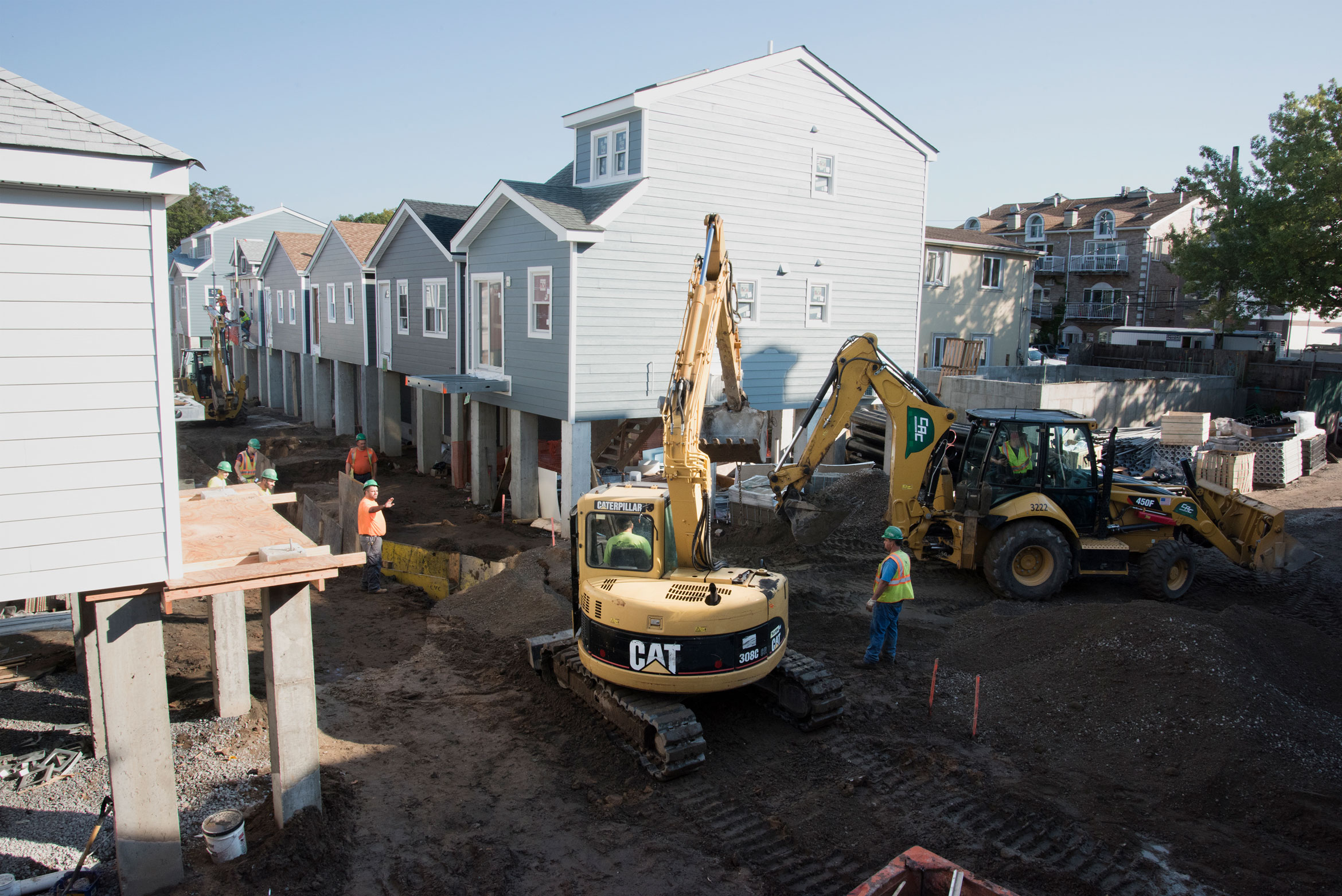
Six years after Hurricane Sandy, Build It Back is coming to a close. Having assisted almost 1,400 homeowners and landlords in Sandy-damaged neighborhoods to remain on the waterfront, the program’s projects have a particular public image: modest single-family homes newly rebuilt on ten-foot piers. But could building back become an opportunity for collective resilience, rather than individual protection?
Architect Deborah Gans has designed dozens of houses for Build It Back, trying to push the boundaries of the program in the process. Here, she walks us through the “courts” of Sheepshead Bay, Brooklyn: rows of bungalows on pedestrian mews, and the site of one of her most exhilarating and thorny projects. Gans came to this water’s-edge enclave soon after the storm as a pro bono community designer; her design team has since liaised with a roster of residents and public agencies to confront the idiosyncratic challenges posed by these homes. As the project nears completion, she reflects on our patchwork approach to disaster recovery and asks how we can do much more than just build it back.
On June 11, 2013, Mayor Michael Bloomberg declared a war against nature. In remarks on the city’s preparation for climate change, delivered eight months after the devastation of Hurricane Sandy, he was resolute: “We’re not going to make the mistake of fighting the last war. We have to look ahead — and anticipate any and all future threats, not only from hurricanes — but also from droughts, heavy downpours … and heat waves.” He illustrated what he called “the futility of retreat” by recounting the houses and businesses situated within the flood zone, home to about 400,000 people and 270,000 jobs. He concluded: “We cannot and will not abandon our waterfront. It’s one of our greatest assets … We must protect it, not retreat from it.”
Some might argue that to return the shoreline to non-human ecosystems is not to abandon it but rather to restore it, and in doing so protect settlements further upland that will eventually face the flooding consequences of climate change — an argument bolstered by the cost required to secure the city’s 520 miles of waterfront. But New York City, among many others, has calculated that the value of property destroyed and, more to the point, the value of future waterfront development, warrant the protection. Published a year prior to Superstorm Sandy, New York City’s comprehensive waterfront plan Vision 2020 fully embraced the growing enthusiasm for coastal living and envisioned currently disused waterfront transformed into play-live-work neighborhoods along a shoreline fortified with barriers, oysters, and constructed wetland, among other infrastructures.
Coastal neighborhoods that are known to be vulnerable to storm surge and flooding, like Greenpoint and Gowanus, have developed and gentrified. As of January 2018, there were about 12,350 new apartments currently under construction or planned in the highest-risk flood zones. That translates into one in eight, or 12.4 percent, of all new residential construction in the floodplain, up from 10.7 percent in 2014, according to real estate website Localize.city and reported in the New York Times. Even historically working-class neighborhoods far from the city center are seeing the impacts: Gross residential sales in the flood zone of the Rockaways increased by 167 percent, to $392 million from $147 million, between 2013 and 2017.
The combined forces of an official city waterfront plan decades in the making, free market real estate forces, and citizens rallying in support of the mayoral battle cry of “no retreat” were significant in determining the course of reconstruction that followed the storm. For one- to four-family properties, the primary pathway has been Build It Back, the city-managed, federally-funded, $2.2 billion program announced in June 2013 to help homeowners and small landlords who had substantial damage from Sandy. It continues to manage the design, repair, elevation, and reconstruction of owner-occupied and small rental properties. When the work is completed, these 1,375 new or elevated houses restored to the floodplain will have a different scale and image from the new towers and parks that have begun to populate the formerly industrial waterfront. But these houses belong to the same projected future of an increasingly desirable coastline in a city of ever-increasing property values.
In this context of “no retreat,” my firm, Gans studio, and the Pratt Center for Community Development — aided first by Pratt architecture and planning students and later by the architects Caleb Crawford, David Cunningham, and Robert Marino — arrived in a waterfront community at the southern end of Sheepshead Bay, Brooklyn, just after the storm. We came originally in response to a request from the volunteer organization Occupy Sandy for additional help with short-term disaster response, and then remained to help plan long-term resiliency, applying the lessons learned from our previous work in New Orleans after Hurricane Katrina. The Gans studio design team remains on the scene six years later in a rather different role: architects within the official Build It Back program. We transitioned from working bottom up with residents on a vision for their neighborhood, to representing their needs to the city, to ultimately participating in the city’s efforts to implement a modified version of their vision.
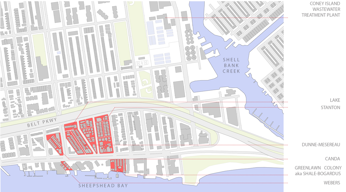
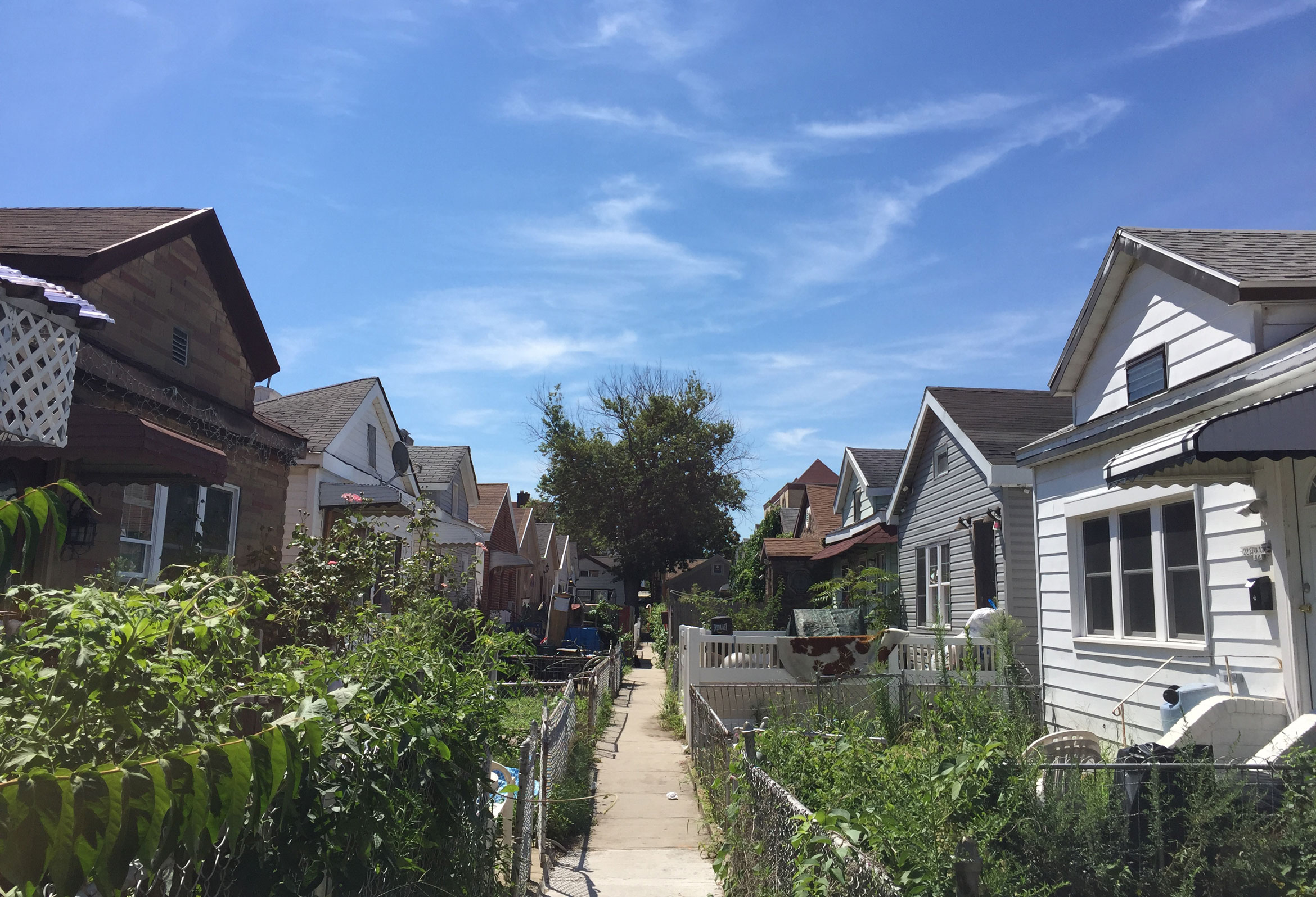
The flooding from Sandy was not only severe but terrifying. It reached the ceilings of the small bungalows, driving families into claustrophobic attics to await rescue by firemen who swam through waters threaded with live electric wires to reach them. These harrowing particulars were the direct consequence of the neighborhood’s urban character and its history. Developed on reclaimed marshland in the 1920s, the courts of Sheepshead Bay were originally summer communities of delicate wood frame bungalows, very tightly arranged on pedestrian mews, an old coastal New York typology found throughout southern Brooklyn and Queens. Over the years, as a consequence of housing shortages and increased land values, all the cottages became primary residences — winterized, fenced, expanded to fill their tiny lots — and made more vulnerable to climate change in the process. The residents are predominantly working class, with a mix of families and an increasing older population aging in place on fixed incomes. Five of the six courts are owner occupied; the sixth, originally named Shale-Bogardus but now known as Greenlawn Colony, is owned by a single landlord who rents the cottages out. On each of the other five, at least one family owns and occupies more than one house and has for generations.
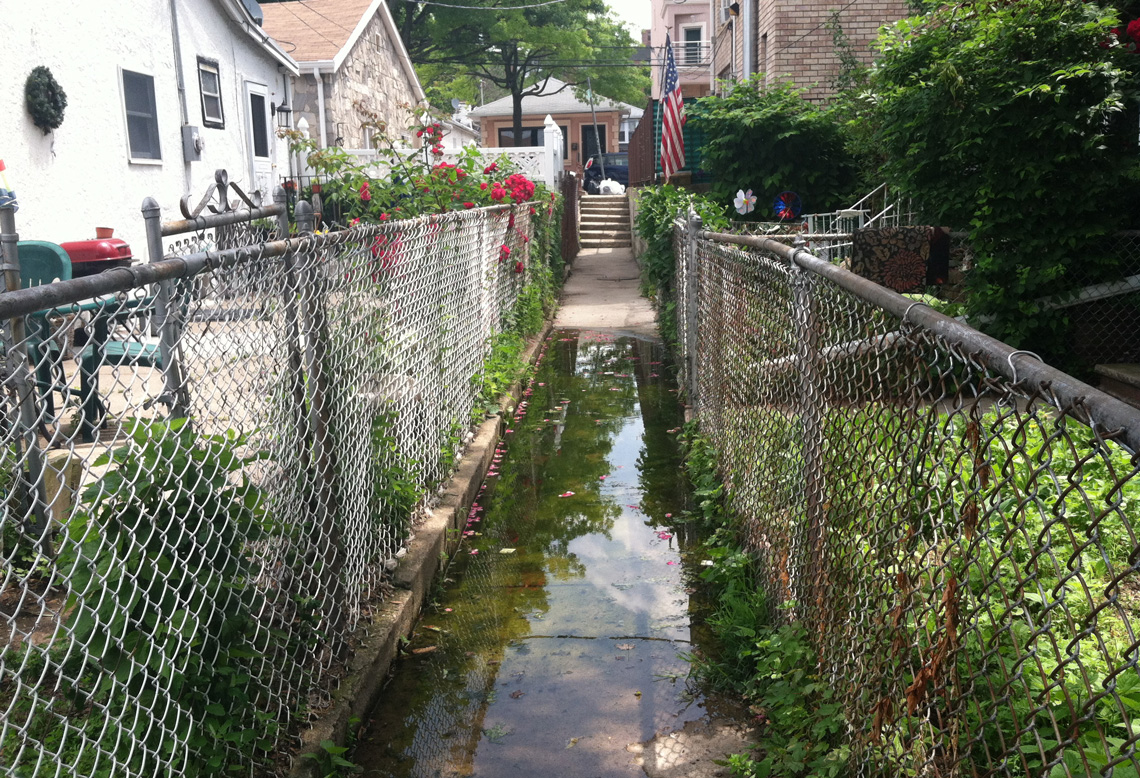
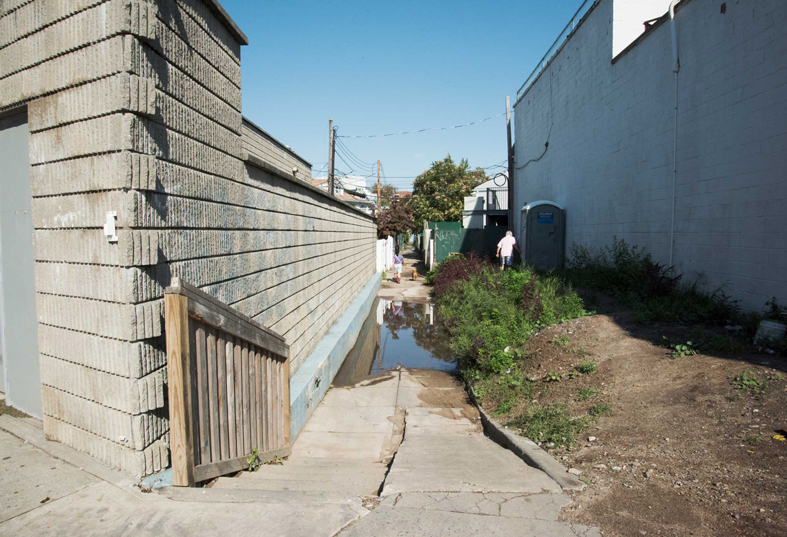
Adding to the courts’ charm but also to their vulnerability is their lowered elevation, ranging from three to seven feet below street level. This sunken court structure was a consequence of the city’s construction of the Coney Island Sewage Treatment Plant in the 1970s, which raised the streets to install new piping but left the interior of the blocks alone. The city’s rationale for excluding the interior was that the pedestrian mews were private easements and rights-of-way through the block, not legal streets — and thus not its responsibility. On the southern, coastal side of Emmons Avenue, the east-west street that abuts the water, the sunken courts can still drain into Sheepshead Bay. But on the upland, northern side of Emmons Avenue, they are surrounded by higher ground on all sides, like bathtubs. During Sandy, water from the surge and the supercharged sewer filled the “bathtubs,” trapping residents. Yet even the rainfall of everyday storms exceeds the capacity of the sump pumps used to remove accumulated water so that flooding from both water and sewage is a common occurrence. Sandy exacerbated this daily plight by cracking pipes in the aged system and filling them with sand.
Our primary question for these longtime homeowners, at the first community meeting in a room just off the bar of the Sheepshead Bay Yacht Club, was: “Do you want to stay?” We didn’t want to make any assumptions. After all, several communities on Staten Island’s eastern shore were opting for New York State buyout programs that returned their homes to wetland. We showed an illustration of a house foundation undermined by erosion from swirling water and sand called scour, which affected many of the courts’ houses at the time. One homeowner wailed, “That’s my house and it’s just fine; it’s not falling down.” Most of the crowd, representing around 60 of the approximately 130 owners on the mews, rejected the idea of buyout, in part because they understood that even a generous deal would not enable them to buy another property in Brooklyn. As Amy Peterson, director of the Mayor’s Office of Housing Recovery Operations (HRO), put it during a project meeting two years later, every unit of workforce housing that Build It Back does not rebuild with federal funding will be an affordable unit lost, thanks to the prohibitive costs of construction for the homeowners. Rebuilding the coastal blocks of Sheepshead Bay after the storm meant mitigating the impact of climactic forces on the waterfront and as well as the economic realities of the residents.
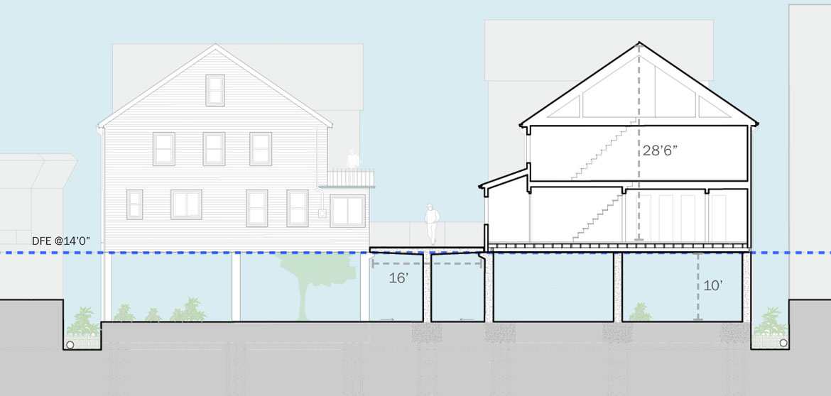
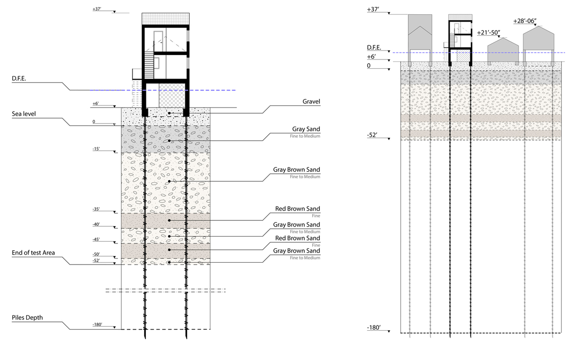
The residents brought to our meetings deep local knowledge not just of bathtub flooding but also of their waterfront, the tides and the moon, storms, and the movement of sand. A few fished for a living and parked boats in their “backyards” on the Bay. They understood that true resiliency required work at the scale of the court’s larger infrastructure, beyond Build It Back’s program of reconstruction for individual homes. A new drainage and sewer system would be needed, along with additional water management and infiltration strategies, and water-safe means of street access. They knew that raising one house would increase the exposure of a neighbor’s house at ground level to scour, and that protecting one home therefore required lifting them all above the 100-year floodplain to the building code’s Design Flood Elevation, or approximately 10.5 feet above the mews’ elevation. None of the 30 or so households who became meeting regulars liked the prospect of new front stairs that would fill their postage stamp-sized yards and require carrying groceries up over ten feet. These shared concerns, in addition to their unified position that the city had unilaterally raised the streets and therefore bore responsibility for the vulnerability of the court drainage to begin with, motivated them to act and envision rebuilding collectively.
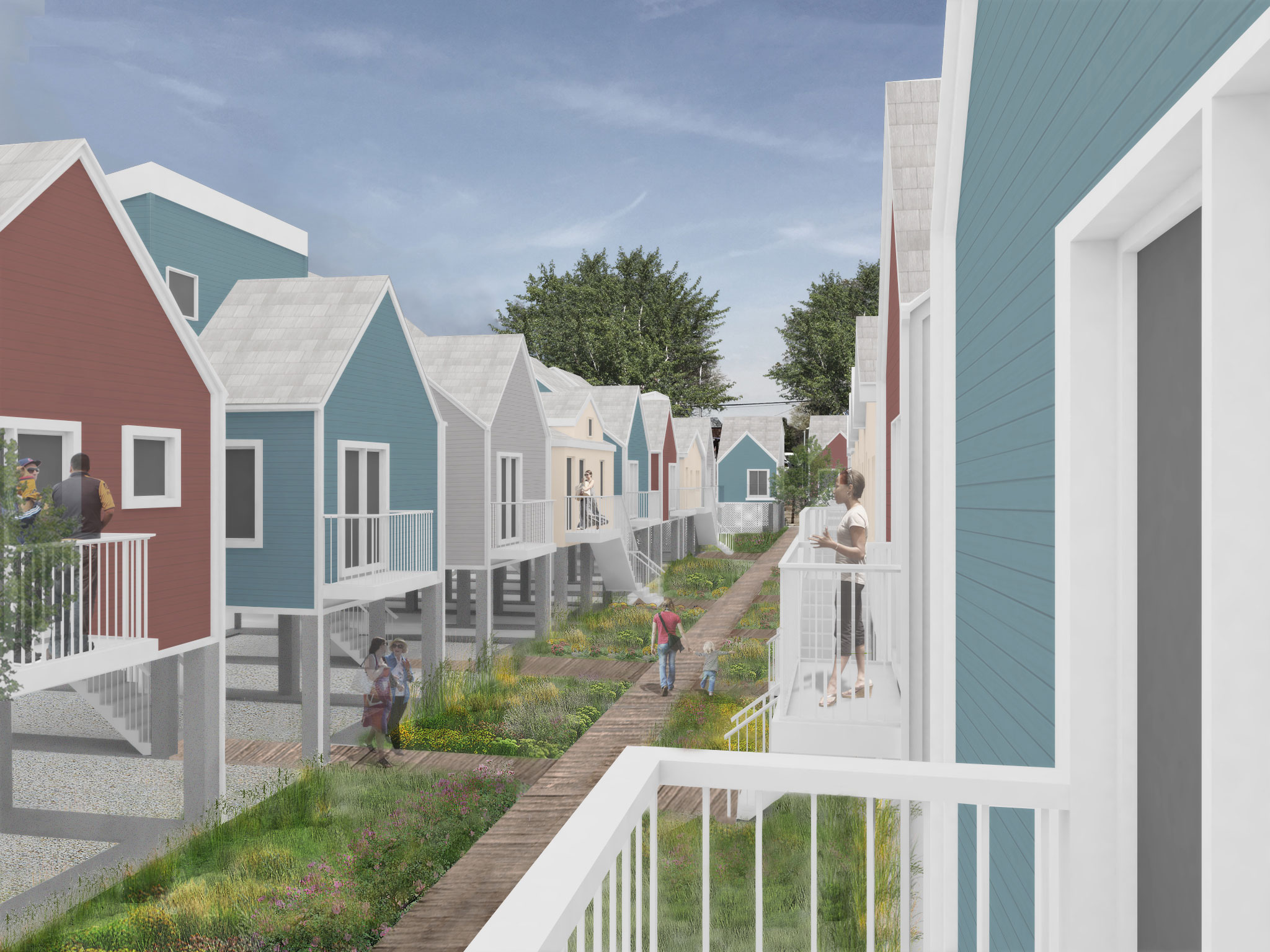
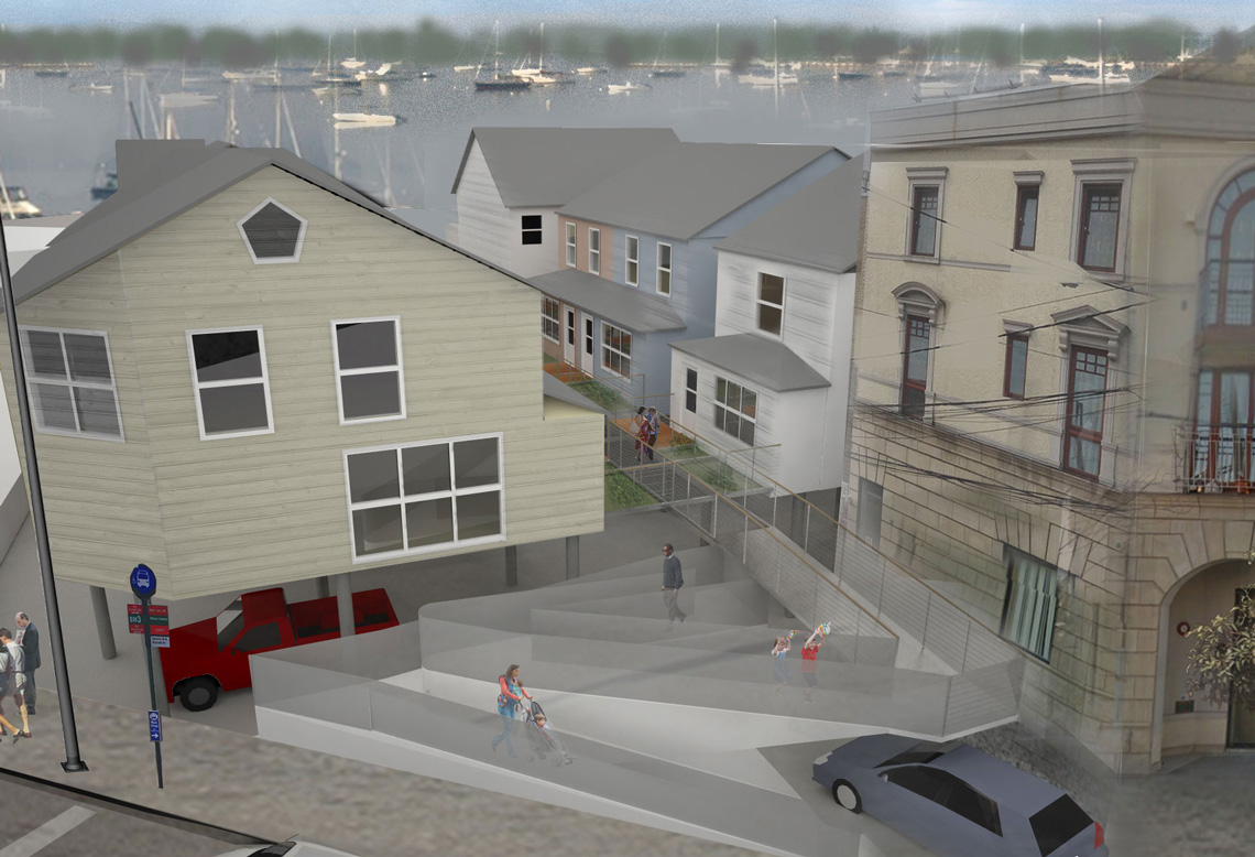
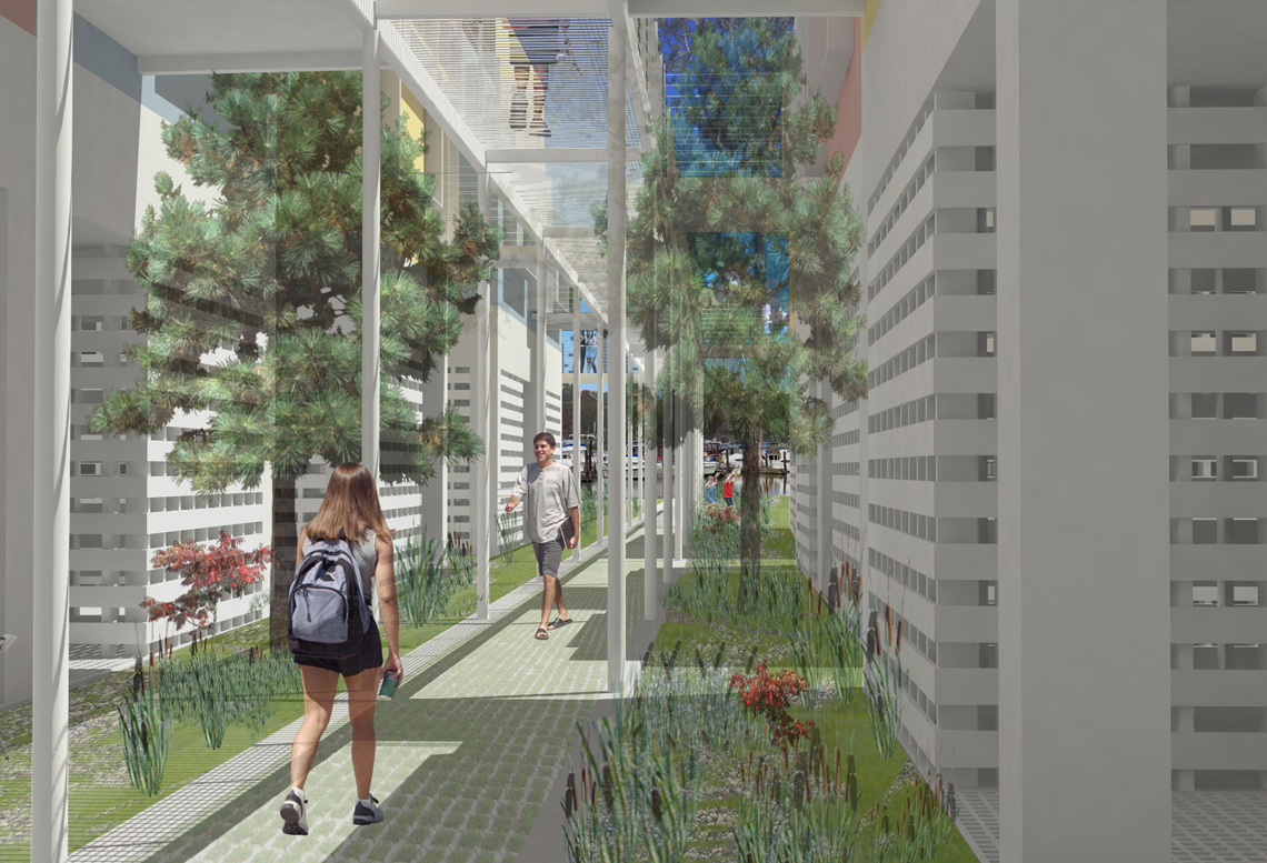
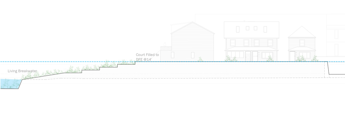
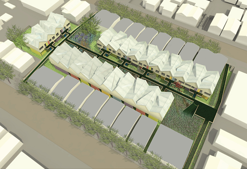
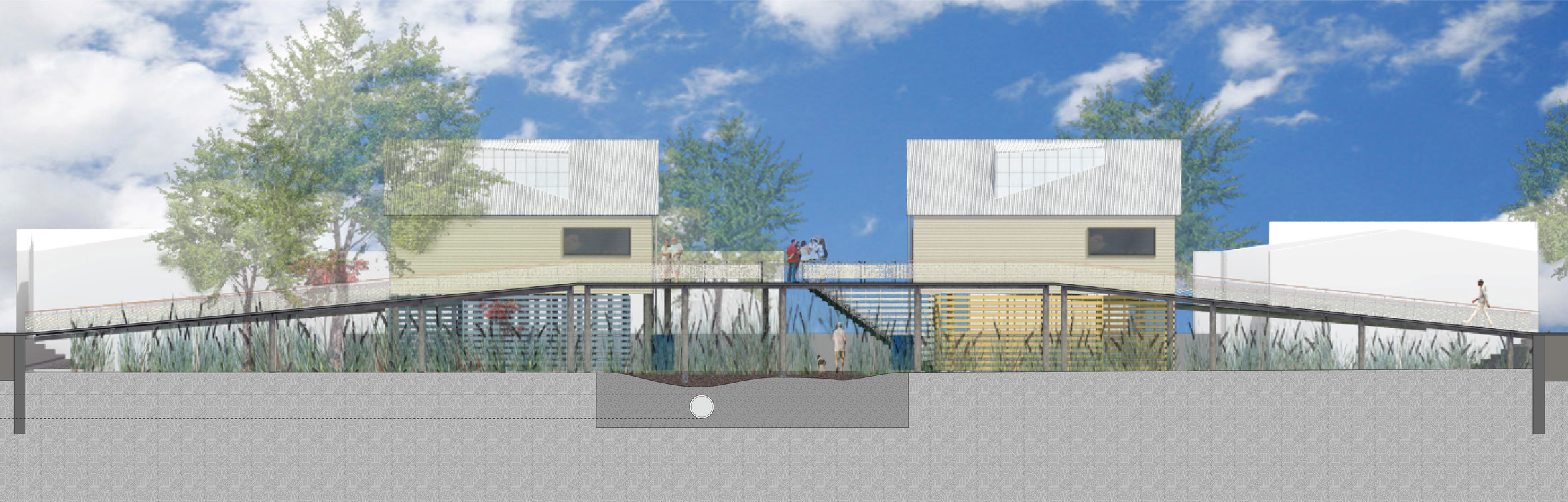
After several meetings with the whole community, our team embarked on an extensive series of design visioning sessions with the homeowners in two courts, Stanton and Webers. These represented the two distinct types of sites and ecological conditions that characterized the locale: an upland court trapped within the street grid (Stanton) and a coastal court exposed to the Bay (Webers). The goal was to develop a water management strategy for each type and then to adapt the approach to the full neighborhood with the homeowners’ input. The proposed new bungalows would be elevated, modular, and designed according to passive house energy standards. In lieu of tall flights of individual stairs, a shared boardwalk would gradually ramp up from the perimeter street and continue down the center of the court, providing entry at the level of the elevated front doors. In the case of a catastrophic flood event, the boardwalk would provide an ADA (Americans with Disabilities Act) accessible exit from the elevated house directly to the street, avoiding the need to negotiate “bathtub” flooding all together. The boardwalk also had a social function, like that of the original pedestrian path, and even added a community-sized porch with stadium seating. From the boardwalk’s perch, the tall piers elevating the houses remained below eye level so that the modest scale and pedestrian “street front” character of the original mews were preserved.
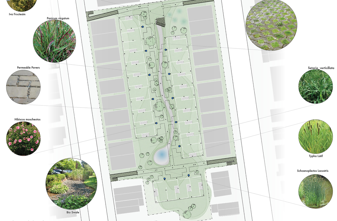
The different site conditions on Stanton and Webers demanded different water management strategies beyond replacement of the subterranean piping, which all of the courts required. Stanton, like the other landlocked upland courts, needed a water management landscape at grade to reduce the loads on the subterranean pipes and sump pump. A path of permeable pavers would meander beneath the boardwalk through an absorptive rain garden. Beneath the houses, several feet of gravel would provide a drywell that could retain heavy storm water as well as the runoff from the roofs above. Meanwhile, Webers, one of the two coastal courts that slope toward the Bay, required swales to enhance its surface drainage. In lieu of a new retaining wall bulkhead along the coast, which waves could breach, we proposed a living breakwater that would host an expanding habitat of plants and marine life and disperse the power of a storm surge. Most importantly, the successful management of water depended on the participation of all homeowners within a court to include their individual properties as part of a collective landscape and a unified pipe system. While the homeowners had often faced the periodic flooding of the mews together, and pooled money to bring in a Roto-Rooter to drain them, a collectively maintained landscape would demand new levels of cooperation they acknowledged could be difficult to sustain.
Fully managing the heaviest storms, likely to occur every ten years, would require the permeable landscape to be installed across all six courts, including the rental properties of Greenlawn Colony. Sherwood Engineers quantified and then outlined the pipes and connective greenway needed to capture enough runoff to avoid this ten-year flooding. The proposed greenway could be established largely on private property, thus avoiding issues of zoning or public access, through front yards and gardens installed on several properties that had been vacant or in bank receivership before the storm. The greenway traversed city property only at the culverts beneath the cross streets and Emmons Avenue as it made its way to the coastal courts, which could then channel the remaining water to the coast through a unified system of swales and pipes.
Our most radical proposal for collective property merged all the houses of Stanton Court into a single tax lot, restructuring ownership as a limited-equity co-op in which shares would be purchased at below-market costs in exchange for limits on resale prices. Currently, the property line of each bungalow extends to the center of the mews walkway, which is officially defined as a private easement among the homeowners for access to the city street. The co-op proposal expanded on the shared ownership already implied by that historical easement in the new context of dual threats from climate change and the exorbitant cost of rebuilding. Once structured as a single lot, the bungalows could be rebuilt as attached one- or two-family row houses, foregoing the existing narrow side yards at the individual property lines. The additional land from those side yards could be ganged and either reserved as water gardens or developed and sold as more housing, which would provide the court residents with some funds for development.
The homeowners at our evening meetings, held in the scattered rooms offered by good neighbors like the Sheepshead Nursing and Rehabilitation Center and the Kings Bay “Y,” understood that the limited-equity coop, the greenway masterplan, and even the boardwalk were aspirations that likely lay beyond the financial and organizational capacity of their beleaguered community. These larger plans would require unknown, creative approaches to policy, funding, project execution, and management because the one existing pathway to reconstruction, Build It Back, applied only to individual houses. Neither the renters nor landlord of Greenlawn Colony even qualified for Build It Back because the court’s scale exceeded the program limits. Meanwhile, residents were living in their damaged homes, sometimes with mold or without heat, or had already been displaced.
Our intention was to craft a vision compelling and detailed enough to win city or state support during their series of neighborhood meetings in the spring of 2013. Although the city and state held their meetings independently of one another, they both explicitly asked for community-wide needs and desires in rebuilding. As a community-based design for a workforce neighborhood, the courts project resonated with the government’s aspirations at both levels. The proposal gained traction as we toured the site with the HRO, New York City Department of City Planning (DCP), Housing Preservation and Development (HPD), and Department of Environmental Protection (DEP), along with planners from the state’s New York Rising Community Reconstruction Program. We supplied our residents with posters so they could present the project themselves at the New York Rising meetings in Sheepshead Bay, resulting in the designation of $150,000 for the design development of court infrastructure. The city concluded: “Amongst these [Build It Back] neighborhoods are blocks of homes with serious design and infrastructure constraints, which will require innovative urban design approaches for achieving a more cohesive neighborhood scale design by working with groups of homeowners linked by common architectural or structural features,” and ultimately engaged us to execute an in-depth feasibility study of the two model courts, Webers and Stanton.
The intent of these feasibility studies was to assess the value to the city of different degrees of investment, including but not limited to the vision we had developed working with the residents. The studies compared the baseline scope of simply rebuilding individual houses using federal funding (the standard Build It Back approach), to our community-based designs, to even more ambitious plans. (One established a wharf at the end of Webers Court with multi-family housing; another eliminated the Stanton Court “bathtub” by raising the entire mews on fill.) The city calculated that the more ambitious plans would require private development funding that could very well displace the current residents. Committed to keeping the neighborhood working class, they decided to fashion a community-wide approach that the government could pay for, as either a special project within the Mayor’s Office (which was our preference) or through a mélange of existing funding streams from both post-storm rebuilding and general sustainability programs including Build It Back, New York Rising, DEP capital projects, and DEP green infrastructure. They opted for the mélange.
The mélange approach had the distinct advantage of limiting local taxpayer burden by using federal Build It Back money for the houses, which were the largest expense. But, without the designation of a mayoral office project, there was no coordinated funding for the community-wide elements. The recovery money from the United States Department of Housing and Urban Development (HUD) grants came at two scales, neither of which met our need: the extra-small rebuilding of individual owner-occupied homes funded through Build It Back, and the extra-large projects like the breakwaters off Staten Island funded through Rebuild by Design. No formal mechanism could take on a holistic neighborhood approach — or even a project that crossed a property line between two homes.
The federal money also arrived with unprecedented regulatory demands and management concerns, which ultimately generated its own distinct city bureaucracy. It required agencies, like the Department of Design and Construction (DDC), who were experienced in administering relatively few, very large projects at a time, to oversee thousands of very small individual homes that would nevertheless add up to the largest expenditure they had ever managed. By the time our team shifted from our role as Sheepshead’s pro bono community-based designers to city sub-consultants, the program had been overhauled several times. It was now run out of the Mayor’s HRO and managed by the DDC, who in turn hired private construction management firms to oversee each borough, who in turn hired us as one sub-consultant architect among many. The program also included staff from HPD, but not from DEP, even though they eventually played an important role in our project. Together, these various agency representatives and the construction management consultants operated out of melded offices, one per borough, and even shared a single email address.
As a consequence of our new role as architects for the designated Brooklyn construction managers, The LiRo Group, our team was unable to continue as community advocates or liaisons — that role having been taken on by HRO — and we were no longer architects of any particular court. Instead, LiRo assigned us to scattered lots among the courts along with their other sub-consultants, Cycle Architecture and H2M Architects and Engineers. It is thanks to the sub-consultants’ willingness to collaborate with us, often informally, that the architecture and infrastructure obtained the degree of coordination it did, since the Build It Back process did not support this holistic thinking.
Because each individual property was a distinct and separately funded project according to the federal rules governing Build It Back, and because each house was a distinct and separately filed project according to the Department of Buildings, the tendency of the city and LiRo was to approach the design of each home as a distinct and separate project unrelated to its neighbors. On conventional streets this was a workable approach, if a disservice to the ideas of neighborhood typology and design efficiency. Within the courts, the easement and absence of a standard street caused enough legal confusion as to the zoning of the lots in relation to the mews that the situation eventually required a ruling from the New York City Board of Standards and Appeals — which came to the rather bizarre conclusion that the houses had no fronts. In other words, the idiosyncrasies of these houses could really only be understood and managed at the scale of the court. Commitment to this new scale of action grew over time among the various players: LiRo, DDC, the other court architects, and the lawyers (both city and pro bono) who worked diligently to bring the homeowners to the table.
After four years of post-storm delays to reconstruction and a decades-long stalemate over “bathtub” drainage, homeowners were, understandably, increasingly distrustful of Build It Back promises and especially wary of entering into contractual legal agreements proposed by the city. HRO had managed to negotiate a plan with DEP whereby DEP would supply new infrastructure on the condition that each court create a homeowners’ association that would take responsibility for its maintenance and the annual inspection fees. Now they had to negotiate with the residents. Rather than sign on, some of the same residents who had entertained boardwalks and limited-equity coops were now so wary of undisclosed costs and city regulations that they threatened to leave the Build It Back program altogether, which would have jeopardized the very possibility of any holistic infrastructure. It took court leaders — self-appointed but universally acknowledged and appreciated — like Jen from Stanton and Cliff from Webers, who organically emerged during our community design meetings, to steer the project toward resolution. Having once circulated a petition demanding that the mews be re-categorized as public streets and thereby qualify for public infrastructure, Jen now worked in parallel with HRO to help broker an eleventh-hour deal officially designating the court infrastructure as a private system managed by a homeowners’ association. Its design and implementation could move forward. Eventually, three of the five owner-occupied courts — Lake, Stanton, and Webers — signed on to receive some degree of collective infrastructure.
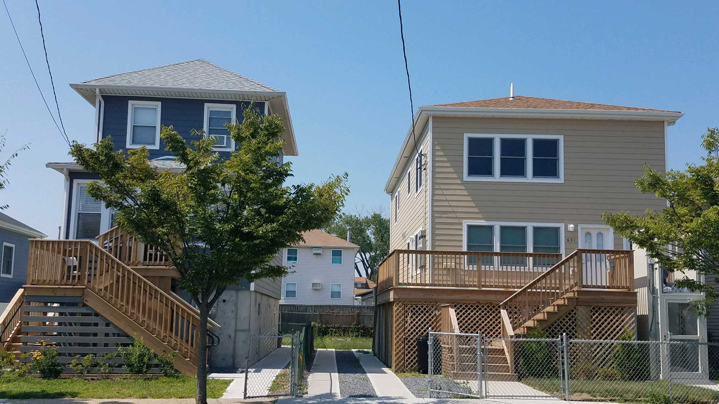
Build It Back will conclude with the courts rebuilt to different degrees of resilience and resolution. The landlord of Greenlawn Colony has put his repaired houses up for sale. On the Canda and Dunne-Mesereau Courts, many houses remain untouched and at ground level among a few that have been rebuilt or lifted. On Webers Court, a new water main and subsurface electrical service will serve all twelve of its houses, even though five of them are not in the Build It Back program. Lake will have a new water main and 20 of its 37 houses repaired, lifted, or rebuilt through Build It Back. The poster child is Stanton Court, which will have new sewer and water infrastructure, subsurface electrical service, and all 19 owner-occupied houses lifted or reconstructed above flood level. The city obtained the remaining five Stanton lots from the bank and two recalcitrant homeowners. In keeping with the original community vision, one lot will be the site for the large drainage backflow device that will prevent storm water overflow from inundating the court. The others could become a water garden or, if the city sells them, new houses. But there will be no boardwalk; rather, each house will sport two flights of stairs, many also with individual ADA chair lifts. And there are no plans for a shared water management landscape thus far, although the New York Rising and other DEP funds could re-emerge to complete it.
We spend the way we think, and we think the way we spend. Individual property and homeownership are deeply imbedded values that policy and funding instruments follow. FEMA and federal Community Development Block Grants — despite their name — only support the kinds of properties that characterize our suburban nation. The inadequacy of our current policy instruments to rebuild a small neighborhood playground or wetland after a storm can impact any community, but in an urban context, this missing scale becomes more evident. The Sheepshead courts offer a lesson in microcosm. The project’s community-based visioning demonstrates that what is impossible to remedy one parcel or property at a time is doable at scales that we do not yet officially articulate, let alone fund. The elevated homes of Sheepshead Bay are now safe from a 100-year flood, but the mews to which their individual stairs lead will still flood, at least temporarily, in a storm surge or hurricane, with no way to leave. Within 30 years, even with all that spending, the waters of the bay will likely lap at the mews of Webers Court on a monthly basis. Thinking and spending at the scale of the court infrastructure — and also the boardwalk and the swale, the block and the master plan — in the context of “no retreat” is essential. Instead of a war with nature, which we are likely to lose, a holistic approach to planning at many scales offers a pathway to détente.
The author would like to thank and acknowledge the following people: Sofia Butnaru provided research assistance for this article. The design team included, from Gans studio, Adam Achrati, Jomana Baddad, Allen Gillers, Sean Gold, Isobel Herbold, Ashley Katz, Rosamund Palmer, Sati Sachdeva, Micah Stroup, Cristina Zubillaga. The design team also included David Cunningham Architecture Planning, Robert Marino Architects, and Coggan and Crawford Architecture and Design; with Markis providing Structural Engineering, Sherwood Design Engineers providing Civil Engineering, and Ryan Consulting Engineers providing MEP engineering services. H2M Architects and Engineers and Cycle Architecture also contributed, for LiRo.
The views expressed here are those of the authors only and do not reflect the position of The Architectural League of New York.


Comments