We are celebrating 15 years — and counting — of stories that are deeply researched and deeply felt, that build a historical record of what the city has been.
We are celebrating 15 years — and counting — of stories that are deeply researched and deeply felt, that build a historical record of what the city has been.
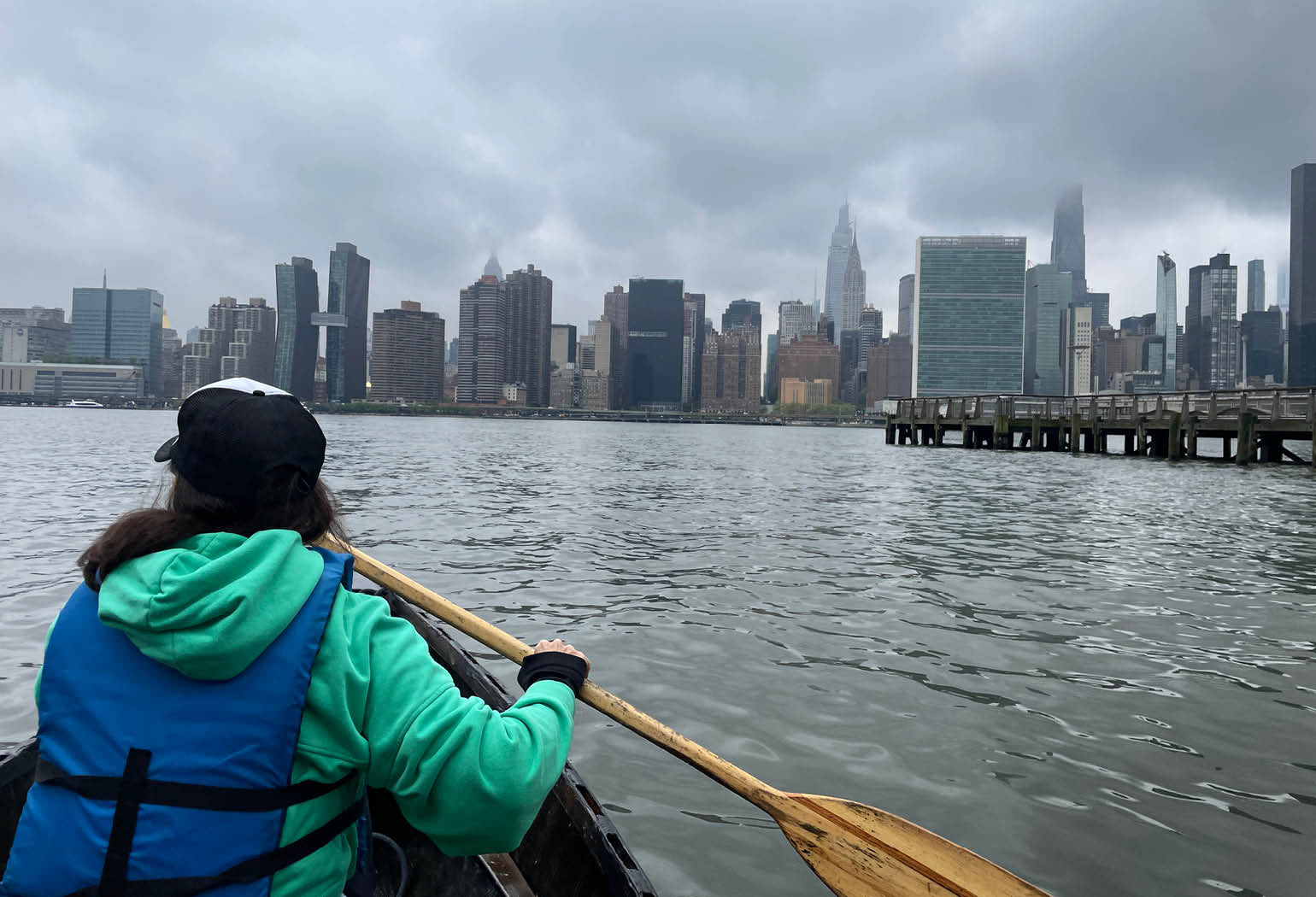
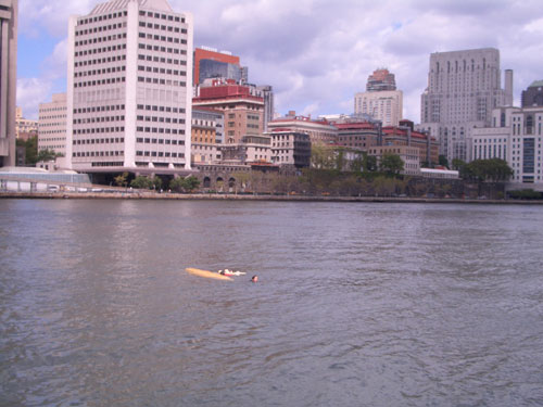
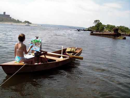
While in some ways it’s never been easier to travel via water in New York City, whether by ferry service or with one of the city’s many boating clubs, there remains a charming audacity to The Tide and Current Taxi. The brainchild of artist Marie Lorenz, since 2005, this artwork-as-transit service has ferried hundreds of travelers in a handmade rowboat to sites throughout New York Harbor. Organized seasonally under broad themes like sound, debris, and mapping, the project was born of a DIY ethos at a time when accessing the water as an individual boater often involved some amount of trespassing. Her archive of photos and written reflections from Taxi trips offer both a veritable who’s who of the city’s tight-knit community of harbor accessibility activists, and a remarkable rowboat’s-eye-view of urban ecology and policy unfolding in real time. Here, the currents and ripple effects of climate change and gentrification manifest more literally in the debris wafting out from the waters around Fresh Kills after Superstorm Sandy, choppy wakes from ferry traffic, and landing points closed off by high-rise “luxury” developments.
In early May, Lorenz spoke with fellow artist and Works on Water co-founder Nancy Nowacek — on the boat, naturally — about the project’s unique vantage on 21 years of waterfront change. They embarked from Newtown Creek, where interruptions from ferry wakes and the Coast Guard patrol demonstrated the nuanced conditions of expanding and contracting public access to urban waterways. Upon returning to shore, Lorenz and Nowacek were approached by two longtime Greenpoint residents, mother and daughter CeCe and Vivi, who recounted memories of regular recreation on the East River in the 1970s and ’80s — fishing, swimming, and even a tubing misadventure that ended in a helicopter rescue. Such a casual sense of public right to the water is all but impossible to imagine today, which is exactly why Lorenz continues to invite people out on her little fiberglass rowboat, as often as possible. – IB
Though I’ve known about The Tide and Current Taxi since 2010, I have no idea why you actually started doing it or how boats in the water became part of your art practice.
The story that I always tell is, I grew up boating; my dad was a sailor; all our family recreation happened in small boats, so I was comfortable around the water. When I moved to Providence for art school in the 1990s, they were daylighting the Woonasquatucket River, basically pulling I-95 off away from the river and making the downtown waterfront district that you see there now. The city was like a giant construction site: Rivers and canals that had been buried in tunnels for decades were being dug up and restored to the surface. I wondered, why isn’t anybody in a canoe in this amazing, magical land? And people said, “The water will kill you, and if you put your finger in it, you’ll pull it back out a bone.” There was all this mythology about how polluted and dangerous the water was. But, you know, it didn’t look that bad. So then I started building boats and taking them into the water. My art practice has veered toward and away from being in the water as its central focus or method ever since.
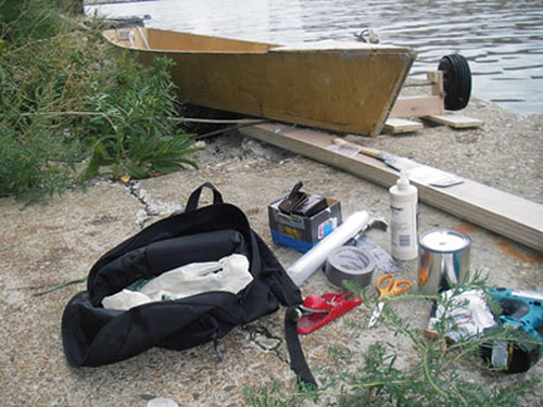
After art school I studied at the The Arques School of Wooden Boatbuilding in Sausalito, California. I always joke that if they saw the boats I make now they would disown me. They build traditional wooden boats, all handmade from timber — not like mine; I use fiberglass and plywood. But I still use some of the things I learned there, like designing the shape of the hull and a process called lofting, where you redraw a boat’s plans at full scale.
When I moved to New York in 2002, at first I had this little inflatable raft, and I would row all over the East River. But then in 2005, I started making boats from fiberglass and plywood. The boats that I made in Providence had been these fantastical objects. I would build frames out of plywood and scrap wood and sheath it with canvas, then use roofing pitch to seal the canvas. They were very fragile, beautiful shapes. When I got to New York, holy crap! The ferries, the traffic: I needed something more reliable than those delicate shapes. So I started using fiberglass.
Where did the idea of The Tide and Current Taxi project come from? I’ve always thought it was so smart and so elegant, forcing people to move with the currents and the tides.
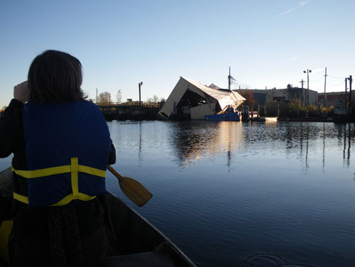
I did a circumnavigation of Manhattan by boat in 2005. A good canoer can do that trip in ten hours, but I didn’t know how significant the tide was. I set out from Greenpoint on a Friday night, and it took three days, camping along the way. Throughout the trip, I was taking pictures and texting them to my friend Melissa Brown, who was at home uploading the pictures to a website that we had set up for the project, the same one that houses the project now. Basically, we were making an indie Instagram in 2005; this point-of-view, real-time photo narration. The two things I figured out during that circumnavigation — oh wait , there’s a huge wave rolling in.
[The boat begins to sway under the waves.]
Yeah, that’s massive. Oh, yeah, it’s from that big guy.
[Nowacek gestures to a large working vessel heading south down the river.]
We’re gonna have an exciting time getting out of here, Nancy. But I don’t want you to panic.
We’ll see.
So, yeah, the circumnavigation made me realize how significant the tide was. I realized at that point how cool it would be to tap into that force. I also realized how many people were looking at the website and appreciating this portal to see the city from the water. Someone would be in an office in Midtown, checking my progress throughout the day. I liked seeing how people perceived the city: through the computer, from a boat in the water. It was a different type of urban portrait, and it seemed to have everything to do with the use of the tide and the cheap technology of photo-blogging. So those were the two things that kind of clicked: The tide is significant, and the web and the tide have this interesting relationship.
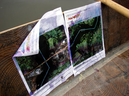
From the very first summer I operated The Tide and Current Taxi, in 2005, it has worked the same way: Participants choose a destination, some place they want to go in New York City. I calculate the best possible time, using a tidal chart of the harbor, and tell them when we have to go based on the tide. We go on the trip, and I make a blog post about it.
As a general rule, anyone can go out in The Tide and Current Taxi, you just have to email me. It ends up being a lot of artists, writers, because that is who hears about it the most, often folks with urban- or ecology-focused practices. I always save one-third of the trips each year for people whom I have never met, have no connection to, who hear about the project online. I like the idea that someone might come across the blog through an internet search, request a trip, and then their trip becomes part of the archive.
I try to write the blog entries for each trip from the perspective of some elucidation that occurred. And it really truly works every time. Every time we see something crazy that warps our whole perspective of the city. One of my favorite times was during the Frieze Art Fair on Randalls Island in 2014. It was being live streamed to the website as part of the fair. I was taking people out into the Harlem River, doing like ten trips a day. I thought it would be boring to keep going into the same place, but it was great. We saw the craziest stuff: eagles, nutria, osprey eating rats, you name it. I realized the second day that there was this sewer tunnel that was only accessible at a very particular moment in the tidal cycle, if the tide was too low, we couldn’t get in there, if the tide was too high the entrance disappeared entirely, but at this perfect hour we could paddle into the sewer and go back like 300 feet. Because only certain people got to go in, it became like this super-VIP event. People would come ask specifically for the sewer. The president of Deutsche Bank almost demanded to go in there with his daughter. It was so great — when do you get the ultra-elite demanding a trip into the sewer? It was a very “only in NYC” moment, and, I would say, an “only Tide and Current Taxi” moment.
One of the entries, from your very, very first trip with Joe Potts, describes a bit of a fated outing where the boat actually starts sinking. I love that Joe’s response is, “I’m shipwrecked and stranded on an island all within a mile of Times Square.” That points to the magical absurdity of this waterfront. There was a kind of psychological distance between life in New York City and what was happening out on the water. And I think what you’re talking about with the website for the taxi is beginning to point to and close that gap.
Can you talk about how each season is different?
Each year I choose a theme that kind of guides the ideas of the trips or the places that we go. It is a way for me to change the focus slightly each year, but really it is very open. Some of the themes have been sort of what you would expect like ‘inaccessible places’, or ‘flotsam’ but some of them are more abstract, like ‘signs and symbols.’ Sometimes I make themes that narrow the requests that I get, for instance one year the theme was ‘bivouac’ and for each trip we had to stay out on the water for 24 hours.
The start of the project really maps onto when the Greenpoint rezoning was approved, which rezoned the area along that waterfront from manufacturing-industrial to residential. We are sitting here in Long Island City, surrounded by high-rises. I can count 11, 12, 13 buildings around us just in this little cove.
Yes!
So since then, we have that redevelopment of the Greenpoint waterfront and of Hunters Point South, which — did you know this — was actually a man-made peninsula built out of excavated soil from the construction of the city’s tunnels and rail lines in the 19th and 20th centuries. So Hunters Point South was a soil dump.
But really, what enabled the redevelopment boom along the Brooklyn waterfront that started in 2005 really started, gosh, we can go back as far as 1972 when the Clean Water Act was passed. Then in 1981 and ’82, the New York State Waterfront Revitalization of Coastal Areas and Inland Waterways Act, which basically said these coastal areas are really important — ecologically and as public space — and we need to think differently about how we redevelop them. Then in 1992, the David Dinkins administration released the first New York City Comprehensive Waterfront plan that was called Reclaiming the City’s Edge. And it really diagnoses the disinvestment in New York City’s waterfront that started, let’s say, in the mid-20th century with the shifts to containerization, planes, cars, and trucking, and away from maritime shipping and rail. That disinvestment created all this neglected, underused space. And so the Dinkins plan is saying: “We have all this space, here’s what we should do with it.” But also, we need a way to balance out the long-standing tension between these competing economic interests — the environment, residential space, and recreation. So that sets into motion ideas about the city’s waterfront that then begin to really take stride in 2005. We are now in 2026 seeing the results of that.
What are some of the things you’ve noticed observationally, but also through the embodied experience of being in the boat in the Brooklyn waterfront, over two decades of doing The Tide and Current Taxi? What changes have you witnessed from the boat?
Part of it has been actual changes, like the ones you’re reading about in the waterfront plan, and then part of it has been my shifting perception of how safe the water is, how accessible it is. When I was first putting the boat in the water — my little inflatable raft — in Greenpoint in 2002, I thought, “Oh, my God, I’m doing something insane.” And now that I look back on it, it wasn’t actually that crazy. There were lots of people boating, I just didn’t know any of them yet.
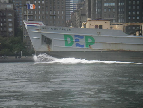
I also think there are way more people interested in the water now. There are more canoe clubs, and there’s more of a public perception that it’s possible to go on the water. And then — as we are experiencing right now because of the wake — the East River Ferry has been a huge change. The waterway has gotten way choppier and more challenging to navigate because of the ferry’s wake. But I wouldn’t trade it. It’s awesome to have so many people in the waterways, seeing the city from a boat.
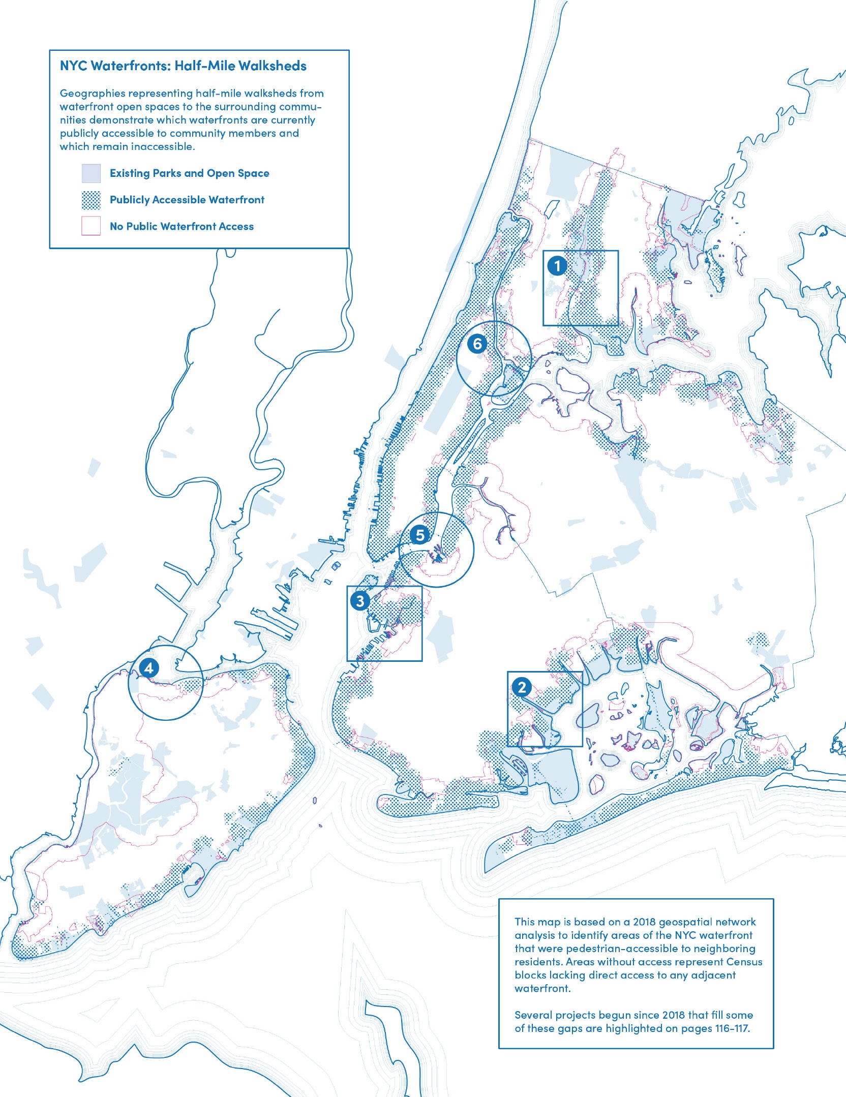
Another thing I would say is that access changes every year. I’ll have a favorite place to launch one year, and then that place will be closed off and a new one will open up. I have this mental map of all the places I’ve stopped over the past 20 years, but it’s always shifting. The New York City Water Trail is a great resource started by Rob Buchanan. It’s always awesome to think, for example, “Is there a place to take out at Randall’s Island?” and then to be able to check the New York City Water Trail and find exactly what resources are at that spot — the legal ones, that is.
What places has redevelopment made accessible to you? Where has it shut down access?
The pier that we’re sitting at right now is a really great example. Before the renovation of Gantry Plaza State Park, there was an uneven bulkhead here. Then, when the condominiums came, they put in this beautiful new pier and floating docks that would be easy to tie up to. But there’s a locked gate from the gangway to the land. I have never seen that gate open before. Who has access to it? I don’t even know. It’s like the architect had one idea, and the landowner had another. That’s why trespassing is important.
I launched the very first tide taxi trip from the empty lot that became East River State Park. I wiggled the boat through a hole in the fence. So, things like that change.
The idea of access can mean so many different things. In so many city planning documents, “access” can be simply a vista, having a view of the water. Access can mean just being next to the water.
So many new waterfront parks and waterfront spaces have been created next to the water, and yet still getting a boat in the water can be challenging. I became interested in New York City’s waterways when I realized, “Wow, I live on an island. I’m surrounded by water. But why do I feel like I can’t get in it and that it’s not for me?” It’s important that all these new spaces exist that have been zoned, planned, and built over the past 25 years. Brooklyn Bridge Park is an amazing amenity. And yet, it still feels like something is missing.
Last fall, on our boat ride with Rob Buchanan, we were looking at the site of a possible new development at Bushwick Inlet, and he suggested the waterfront has been basically reduced to an amenity for these luxury apartments by the developers.
When you read Vision 2020: New York City Comprehensive Waterfront Plan released in 2011 during the Bloomberg administration, “enhance” and “enliven” are recurring words. But then, there’s a wonderful shift in the most recent waterfront plan, from 2021, it recognizes the disparities in power and access across communities on the waterfront and begins to talk about “equity,” “resiliency,” and “health” as beacons for future development: how we live with the water, what we do with the water, and how we build the city close to and on the water.
If we trace that back, we go from, in 1992, “we have all of these neglected spaces, let’s develop them,” to, now, a recognition of how communities got pushed to the city’s edges and are vulnerable to so many forms of systemic oppression.
Don’t you wish you could go back in time and put the equity one before the super-development money-making one?
That would be amazing. For so long, we existed here in New York City because of the coastline’s commercial and economic capacities. And now that that’s less of a consideration, we’re seeing this beautiful arc of the city saying, how do we make the waterfront for all people? For me, equity means increasing access to swimming lessons, small boat access, water safety education.
Are there any places left along the Brooklyn waterfront or any part of the city’s coastline that still feel wild?
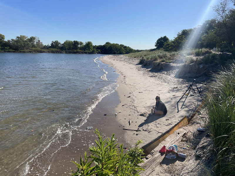
Many, many places. Lots of them are not that much bigger than that rocky slope over there. Either by design or accident, these little embankments are all over — riprap, but then also sediment, sometimes plants, and always lots of trash. These micro edge zones in between areas of development. And the islands, of course, are amazing wild spots.
Here, we’re looking at Roosevelt Island which has a cool, beachy, cement breakwater all the way around. The south-facing wall is perfect on a summer day, with a beach towel and a picnic. If you tried to cross the wall from the land side, a security guard would probably stop you. But I’ve taken the boat and hung out there. The security guard must just think, well, it’s not my problem. So we could say that Roosevelt Island has a wild perimeter.
Mill Rock Island is fun to land on. There’s a little cove, too, if you don’t want to take a break but don’t want to break the law. It’s totally protected from the current and big enough for ten canoes to chill in.
So, there are beautiful little spots that you can only get to on a boat. Maybe in the ’90s, more people had access to spots like that from shore, but even then, it was really only the people who knew to peel back the fence. The elite trespassers, in a way.
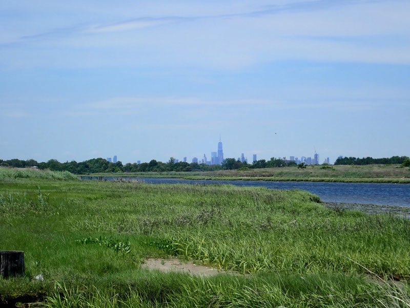
From my experience with Walking the Edge (the Works on Water art collective’s walk of all 520 miles of New York City’s coastline) this past summer, there is still a lot of wildness in parts of the Bronx and around Coney Island Creek, and parts of Staten Island. Some of those pockets have become spaces taken up by unhoused folks, which is something the waterfront always has been party to. There are so many places still in the city today — I’m sure you felt this — where the city seems a hundred miles away, peeking through grasses or trees.
There’s another aspect that I think about a lot with The Tide and Current Taxi, which is feeling safe as a woman. For me, there’s always a sense in the boat that I’m in complete control over my surroundings in a way that I’m usually not in New York City. And that’s what I’ve always really loved about it.
There was one trip, maybe ten years ago, my friend Elsie Hill came out with me to Coney Island Creek. It was right after that article about the ghost ships of Coney Island had come out. We were out there for hours, and Elsie was in her bikini, doing still-life paintings of the ghost ships. I was reading and taking pictures. Totally relaxed. We were like 100 yards from a gas station, in between construction sites, with people all around. We never would have done that if it weren’t for the boat. Even in Prospect Park or something. It’s a feeling of freedom. We were totally in control.
Can you talk about your understanding of climate change and sea level rise as you’ve felt it over the years of doing The Tide and Current Taxi?
My perception of sea level rise is like most people’s: I get a sense of it from the news and maybe some published data. But there are a few things I see in real life. For example, it used to be rare for the water to go into that little alcove we were standing on when we launched our boat today. Now it covers that area during most high tides. There are a few areas like this that I can mark for myself.
Superstorm Sandy marked this kind of shift in the city’s understanding and conversation around climate change. You were doing this project before and after Sandy, how did that shift your experience?
I was stuck in Texas when Sandy happened. But I got back on November 4th, and went out with Elizabeth Rush, who had been studying Fresh Kills. She wanted to see the area because no one had been reporting on it. She was like, “Holy shit. What happened to Fresh Kills?”
We paddled into the area and started seeing damage immediately. We could see that the water had been 15 feet higher than high tide. There were these heavy sediment booms sort of flung up over the retaining wall as if they were pillows. The sheds meant to protect work vessels were crushed in the direction of the current. But the biggest thing that I remember from that day is that the New York City Marathon had been canceled, and hundreds of people who planned to run had come to Staten Island instead and were helping with the relief effort. They were wearing their marathon numbers, but moving debris and delivering supplies. It was the coolest thing.
What other changes have you noticed over the past 20 years?
I go all over New York Harbor with my boat, but I spend about half the time on Newtown Creek. I would say that the water quality is getting better. I can smell it and I can see that Newtown Creek has more mussels. When I was making the Newtown Odyssey, a waterfront opera in 2023, I was out at Plank Road, which is a street-end park that the Newtown Creek Alliance has done a beautiful job of maintaining, gardening, and stewarding. It was incredible looking at the variety of wildlife. I mean, this is a Superfund site near one of the biggest sewer outfalls in Queens, all the way up into the grossest part of Newtown Creek.
These kids go fishing in there, which is amazing — always catch and release. I saw one pull out a three-foot eel writhing around his hook, this kid was wrestling with it. I saw them pull out striped bass many times. My time that summer on Newtown Creek really changed my perspective about this place. It’s the most polluted waterway in New York, and it’s teeming with life. And that’s heartbreaking because it’s definitely a result of the Clean Water Act, and now those legislative protections are being stripped away. So, what is that, 50-plus years, for it to get a little better? And now it’ll probably take just five years to turn it back around.
[Lorenz and Nowacek begin rowing to shore, having timed their return with the passing of boats because of the waves. At last, they lug the boat up on land.]
Okay, so we’re back on land. We had a really effortless trip back from Gantry State Park.
And the last thing I want to ask you is — as this Canadian goose just takes off into the air like an airplane out of LaGuardia, here it comes, it’s circling around, wow — what is your New York City waterfront fantasy vision? Where can you imagine the waterfront in another 20 years?
I was thinking about the idea of expanding access, and what that will mean for the waterfront. I was thinking about finding these pockets of wildness, which are what we remember of ‘90s New York, and how now they’re fewer and farther between. Maybe you need a boat to get to them now. And I was thinking what the negative and positive implications of that would be. The nice thing about exploring areas like that in the boat is that it forces you to slow down and really see them and experience them.
My fantasy for Newtown Creek would be a ring path like some of the ones in Austin, Texas, on Town Lake, where the perimeter walking trail leaves the land and goes 50 feet out, like a wide boardwalk over the water. It’s cool because the bank itself can be wild, a soft bank, which is important for wildlife. It would preserve the natural areas but reveal the industrial ones too. It could cut right through all the gas tanks and power stations, and then sometimes go out over the water, like around Plank Road, where there’s that beautiful soft bank, and you could watch cormorants hunting for eels.
That’s a great fantasy. I think my fantasy is a city that trusts its citizens to act within reason around the water and remove the fences and barriers. And the possibility, as the water gets cleaner and cleaner, in certain places, to simply walk into the water for a swim.
Oh, my God. Yeah, yeah, let’s have that.
I know it’s impossible in most places in the city because of the currents and because of the commercial traffic, which I don’t think should go away. I love your fantasy. That’s really about softer edges and balancing human and more-than-human needs.
My fantasy would include swimming lessons and boating lessons and access to learning and knowledge, where people are encouraged to be curious about the water, and they feel safe to pursue their curiosity about the water.
I want that too.
I always quote the Public Trust Doctrine, but I noticed you quoted the Dutch man, Hugo Grotius, and his concept of the Freedom of the Seas. Is that what you feel gives you the support to kind of be out on your boat poking around?
I love that document because it’s one of the oldest international laws — one of the first times that nations agreed to obey each other. I always bring up the part that says, if a sailor has trouble at sea, he’s allowed to land on any shore. I jokingly use that when I’m landing in places that are illegal — I always think, “well, you know, if you think about the first international law, Freedom of the Seas . . . I’m allowed to land here because I need to.” But the fact is, I was rarely stopped at those places anyway.
Then you pull out your scroll . . .
Yes, exactly. By decree of 1609 . . .
I want to end with a quote from a Tide and Current Taxi trip from last summer: “Origin Stories” with Sasha Cravis and Rachel Yanku. Right when you guys are looking at what’s happening all around us — the redevelopment in Greenpoint and this first high-rise built on Newtown Creek — you say, “We looked at the new high-rises. The land here at the mouth of the Newtown Creek used to seem abandoned, underused, but still somehow inaccessible.” And Rachel says, “Now it is inaccessible in a different way.” It sums up the complexity of accessibility which means all these different things to different people — boaters, swimmers, fishers, developers, rich folk, poor folk, waterfront workers. One man’s accessibility might be another woman’s inaccessibility, and vice versa.
The views expressed here are those of the authors only and do not reflect the position of The Architectural League of New York.