
We are celebrating 15 years — and counting — of stories that are deeply researched and deeply felt, that build a historical record of what the city has been.
We are celebrating 15 years — and counting — of stories that are deeply researched and deeply felt, that build a historical record of what the city has been.
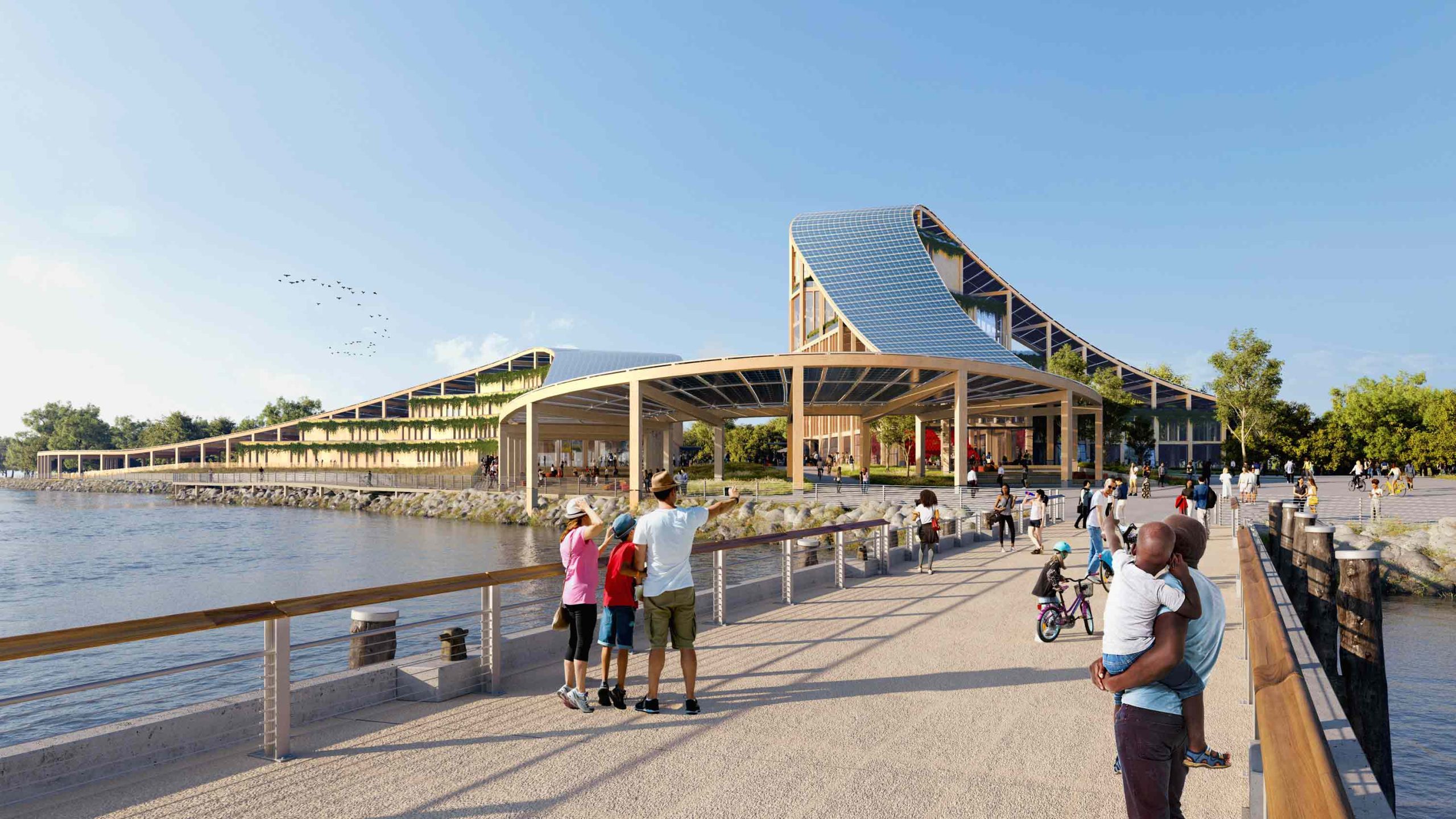
The consequences of the climate crisis for New York City’s future can be hard to assimilate. Rising tides and strengthened storms threaten our archipelago inside and out; keeping the population safe and dry requires physical adaptation to the city on a monumental scale. New York may not be Venice or Vanuatu, but our dozens of islands float in an era of uncertainty. Last year, the US Army Corps of Engineers presented the public with uninspiring renderings of massive sea walls rejecting the waterfront nature of some highly valued real estate. Of the plans to address flood risk in the New York and New Jersey Harbor Region, the Army Corps hedges on its website: “There is a considerable amount of work left to be done on the study.” Meanwhile, plans move along for new facilities to monitor and mitigate climate change on Rikers and Governors Islands, even if it is hard to imagine those sites staying above water in the long term. It’s a lot to take in. As existential questions loom large and unanswered, Russell Jacobs sounds our surrounds in search of a manageable measure of the city’s future. What piece of land, he asks, embraced by rising tides, might become New York’s next island?
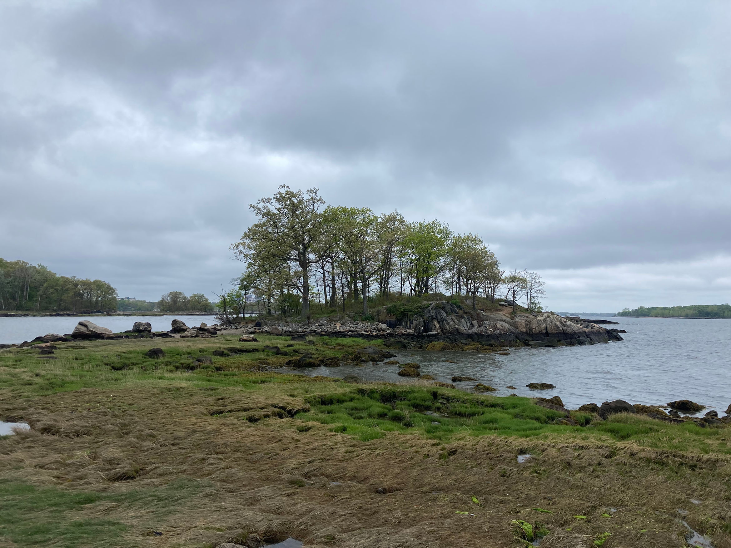
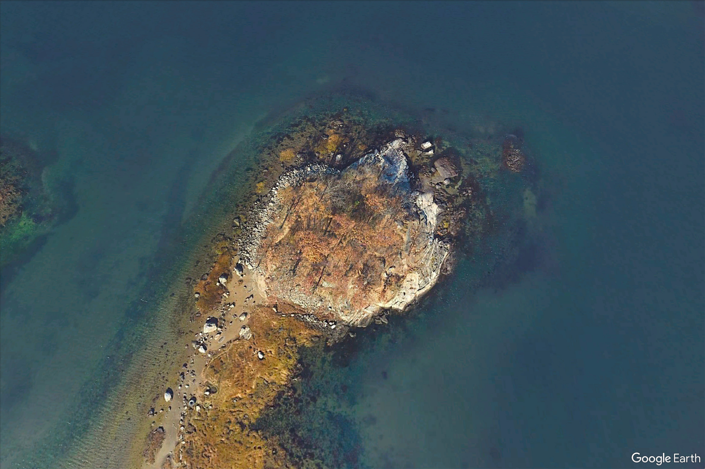
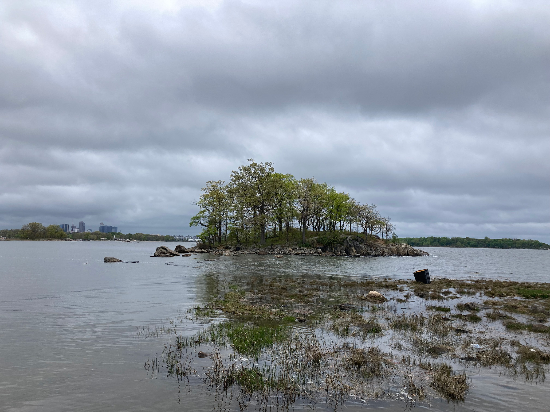
The other day, I rode out to Pelham Bay Park to watch a landmass the size of a basketball court break off from the rest of New York City and slide into the Long Island Sound. The landmass is called Two Tree Island, which is a misnomer for two reasons. The first is that it has many more trees than that: fifty or so oaks of a few different species form a little glade where hikers and fishermen can get out of the sun on hot summer days. The second reason is that it’s not an island, at least not yet. A ribbon of gravelly sand pockmarked with tidepools and lined with marsh grass still connects it to Pelham Bay Park most of the time. I had come an hour or so before high tide to watch the water wash over the path, separating Two Tree from the mainland Bronx.
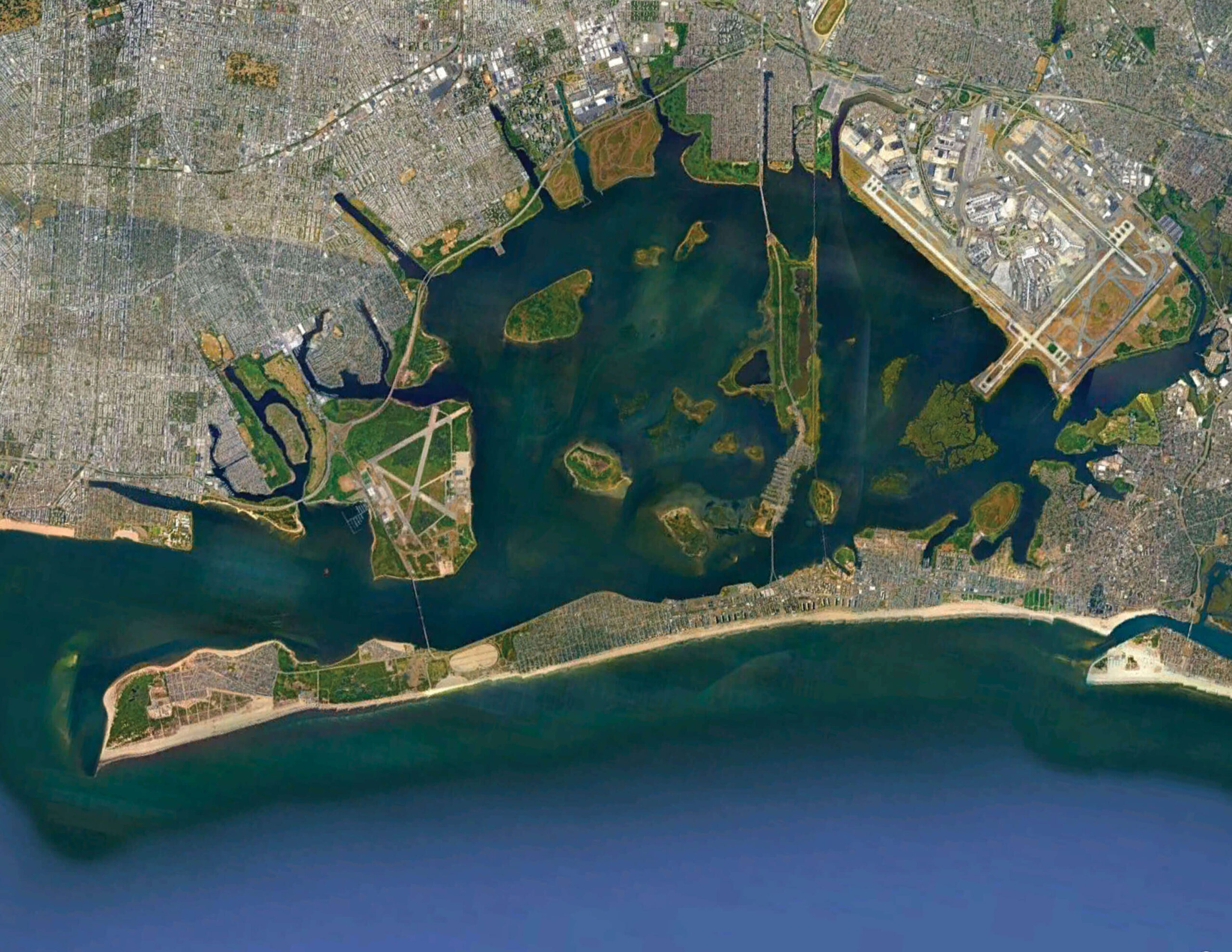
New York City is an archipelago that contains somewhere between 30 and 50 islands, depending on how you count, and what the tide is doing. Manhattan, Staten Island, and Long Island, the western tip of which contains Brooklyn and Queens, are the busiest. A few others, such as Roosevelt Island in the East River and City Island in the Long Island Sound, are home to apartment buildings and businesses. The majority are uninhabited by people, and inaccessible to anyone without a boat. It seems certain that as water levels rise, and storms become more powerful and frequent, the exact number and composition of these islands will change more rapidly than it has for the last few centuries, with some washing away, and others appearing. I had come out to Two Tree because it seems like a good candidate for the next piece of land to split off permanently.
A few years ago, I started thinking about where New York City’s next island might emerge. It was my way of trying to wrap my head around the looming changes that rising seas and powerful storms would bring to the city, a transformation so large and consequential that, when I try to imagine what it might actually look like in a day-to-day context, my mind goes blank. In the eleven or so years since Sandy tore through the city, there has been so much said about the urgency of the climate crisis and the need to rethink everything — from building codes, to insurance, to coastal living altogether — that I’ve become incapable of imagining what the city will look like in 50 years.
Depending on who you ask, staving off the water will require us to build dozens of miles of new sea walls and floodgates, elevate structures, roadways, and entire neighborhoods, or relocate tens of thousands of people from low-lying, flood-prone areas. In a city that regularly fails to clear snow from many of those same places, let alone build enough housing to accommodate New Yorkers in the neighborhoods they already live in, it seems unimaginable that all of those things will happen. It’s just as impossible, on the other hand, to imagine what will happen if they don’t. An island, however, is tangible and measurable. Watching a piece of the city slip out into the water seemed as good a way as any to try to come to terms with the fact that the water, and not us, will make at least some of the choices about what New York City looks like in the future.
Standing on the rock ledge at the eastern tip of Two Tree, I could just make out a few of the city’s lesser-known islands. Danny Hat Island, a little rock too small even to make the index of my copy of Sharon Seitz and Stuart Miller’s The Other Islands of New York City, was a few hundred feet away. Off to the south, poking out from behind Pelham Bay Park, was Hart Island, a potter’s field where over a million of the city’s unidentified dead have been buried since the 1860s. I considered stranding myself out on Two Tree for the sake of this story, but chickened out in time to scamper back to the mainland and watch the water wash over the path from the safety of a boulder. The tidepools expanded slowly, and then merged one by one until finally, after an hour or so, the sand was gone. Aside from me, the only witnesses to this transformation were a few little killifish who darted back and forth across the path, exploring the new channel cautiously.
Two Tree makes its bid for independence twice every 24 hours, as the tide moves water up the East River and into the Long Island Sound. A few hours later, like a moody teenager who runs away from home in a huff only to show back up at dinnertime, it always makes its way back to the Bronx (the only borough, incidentally, that is neither an island nor a part of one). It seems likely that sooner or later, the sand will erode far enough to cut Two Tree Island off for good and give the fish a permanent channel.
The exact number of islands in the city has never been fixed for very long. Archipelagos are fickle landforms to begin with, with a lot of surface area exposed to moving water. For millennia, the Atlantic Ocean and the city’s rivers have been slowly shaving off pieces of the shoreline here and adding land there. Occasionally, those natural transformations have been abrupt: big tropical storms in 1821, 1893, and 1936 reshaped the city overnight, tearing off sandbars and breaching barrier islands in the sandy coastlines of southern Brooklyn and Queens. In the 1860s, a mass of sand called Hog Island appeared in the ocean just south of the Rockaway peninsula, only to disappear again in the early 1900s after swallowing the fortunes of a few overly eager developers. Over its relatively short lifespan, Hog Island hosted saloons and bathing pavilions, and developed a reputation as a hangout for corrupt Tammany Hall politicians.
Although the future of the city’s physical geography feels less intimidating than the broader, more apocalyptic uncertainties of climate change and sea level rise, it isn’t any easier to know exactly how it will change. From a mathematical perspective, the ways that sand and silt respond to tides, currents, and winds are notoriously tricky to predict — so much so that Albert Einstein, whose son was an engineer in that field, famously called it “a more difficult problem” than his own life’s work.
Philip Orton, a physical oceanographer at the Stevens Institute of Technology in Hoboken, New Jersey, has made his career studying how water interacts with the city’s shorelines, modeling currents, flooding, and other related phenomena in the area. In the years since Sandy, that work has taken more urgency.
“When I started working with a hydrodynamic model of the region,” he told me, “I immediately wanted to play like a kid in a sandbox.” Orton’s computer model allowed him to rearrange the topography of the city, adding and subtracting marshes and other features, and adjusting the depths, to simulate how various changes might impact flooding in different weather conditions. In the wake of Sandy, as conversations about flooding became less abstract and the impetus to fortify low-lying parts of the city grew, he honed in on the sandy shorelines in southern Brooklyn and Queens.
“Right away,” he said, “I saw Jamaica Bay was really interesting.”
A lot of the conversation about Jamaica Bay’s resilience has focused on the marsh islands, which have been shrinking over time. The US Army Corps of Engineers has been rebuilding them slowly since 2006 with the hope that they will mitigate future storm surges, but when Orton played around with his models, it was the century-old channel system, dredged when the bay saw more boat traffic, that really stood out as the key to the flooding issue. The dredging, he suspected, had depleted the bay of huge swathes of sediment, removing the stuff that accumulates in the grass to make shoals and islands in the first place.
“It’s not necessarily the grass that breaks waves or reduces a storm surge,” Orton explained. “It’s also the substrate — the elevated bathymetry where you have marshes, and the fact that they trap sediment.”
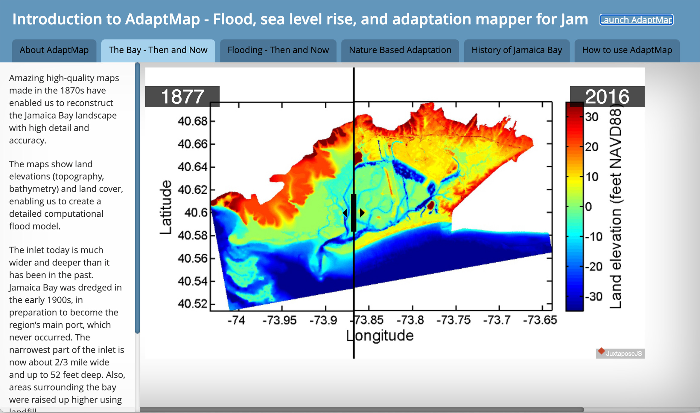
In 2015, Orton tracked down Eric Sanderson, who recreated Manhattan’s 1609 topography in his book Manahatta, at a speaking event at the South Street Seaport Museum. Before long the two of them were collaborating on a historical model of New York Harbor. Sanderson, a forensic ecologist whose work involves digging through primary sources to reconstruct data about historical iterations of New York City’s landscape and ecology, helped fill in the blanks about Jamaica Bay’s history. Using old maps, ships’ logs, and journals, they pieced together the bay’s previous geography and bathymetry (the measure of depth of water in oceans, seas, or lakes), and then plugged it into Orton’s model. The result was AdaptMap, an interactive tool launched in 2016 that allows scientists, engineers, and anyone else who is interested to recreate historical conditions and test the susceptibility of those landscapes to flooding.
Neighborhoods on Jamaica Bay were among the hardest hit during Sandy, with devastating flooding on Broad Channel, Howard Beach, and many parts of Rockaway. When Orton and Sanderson plugged the storm surge into their model of the bay in 1877, before the channels were dredged, the flooding was dramatically reduced.
“The 1870s landscape treated tides and storm surges a lot differently,” Orton explained. “It basically muted them — dampened them out to some extent — whereas the modern system amplifies them.”
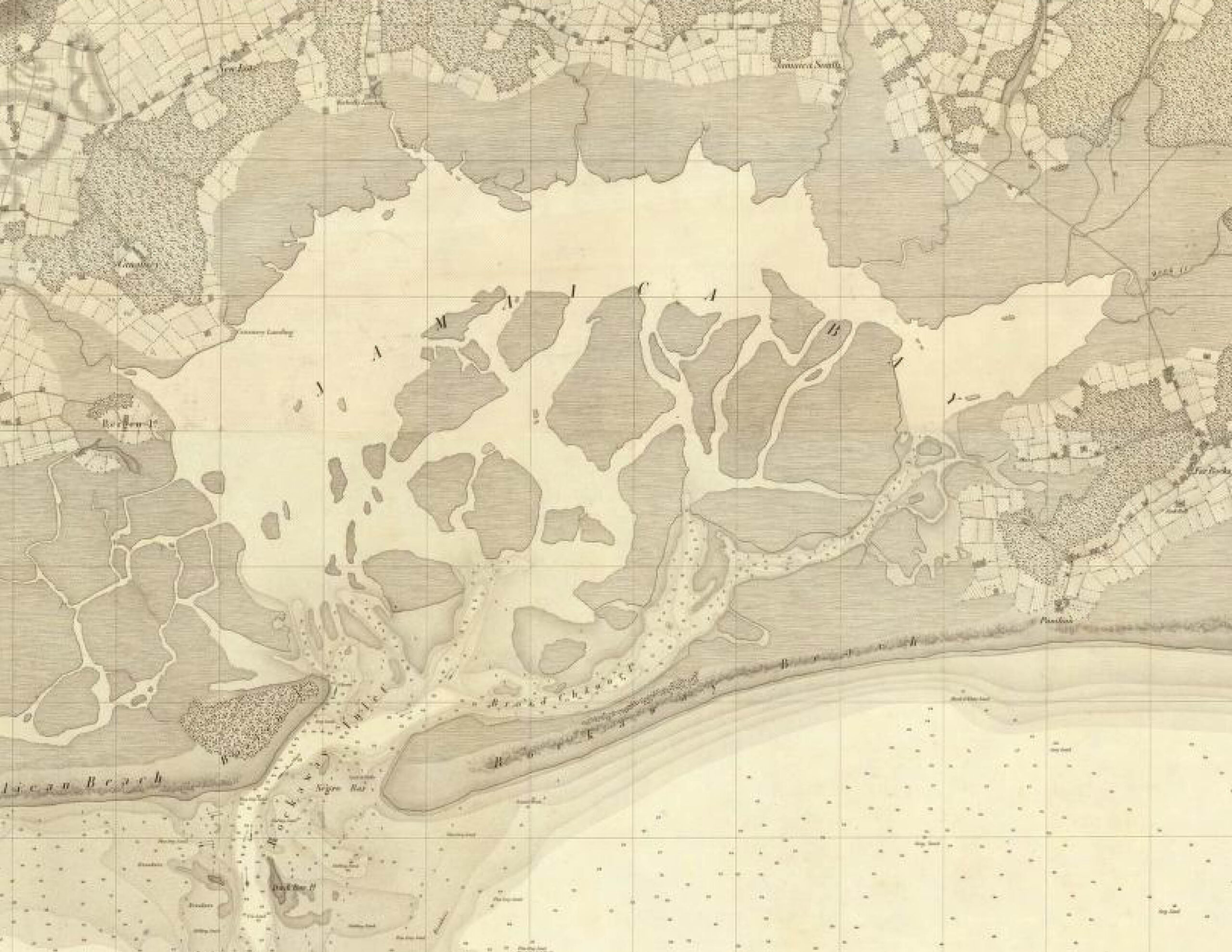
They chose the 1870s because a set of maps from that period had highly detailed depth readings of Jamaica Bay, which gave the model a lot of data, but the AdaptMap website also features several historical maps of the area going back as far as 1651. Flipping from map to map, you can watch islands appear and disappear along the edges of southern Brooklyn and Queens, moving around and dissipating like storm cells on a radar screen. A British map from 1782 shows a barrier island between Rockaway and Coney Island, but by 1811 it seems to have disappeared. In the next map, a new inlet has torn through the peninsula further to the east, making half of the peninsula a new barrier island. A helpful note reads: “New Inlet, Opened Jan. 1839.”
“We think that there used to be so many more islands in Jamaica Bay, and it was so much shallower in the center of the bay, and that was because the system had a lot more sediment,” Orton said. “Now there’s not much sediment supply. It’s all urbanized, and the sediment is just bleeding away into the deep channels.”
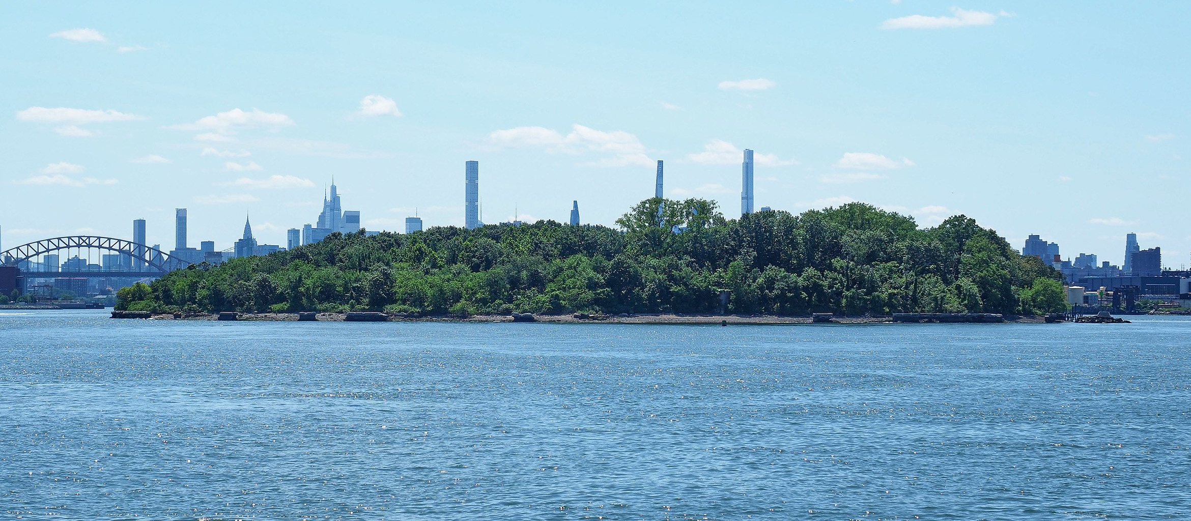
With so much of the shoreline reinforced with concrete, it’s not so easy for the land to shift around like it used to, but the archipelago still changes. In addition to the occasional squall that can tear apart Jamaica Bay’s softer, uninhabited islands, city government has done its share of island-scaping, adding and subtracting from the archipelago to meet the city’s changing needs. In the 1870s, when cholera and smallpox epidemics were picking up speed, the government built Hoffman and Swinburne Islands, grim rock stacks piled on dredged sand in the water off of Staten Island, to serve as quarantines for passengers on transatlantic ships where outbreaks had occurred. U Thant, a tiny island built in the East River in the 1890s, was the solution for disposing of all the rubble created during the construction of the subway tunnel that now carries the F Train under the East River between Manhattan and Queens. And to create Floyd Bennett Field, the city’s first airport, engineers contracted by the city’s bygone Department of Docks and Ferries combined Barren Island with several of its smaller cousins in Jamaica Bay, connecting it to the rest of Brooklyn with landfill in 1928.
It’s possible that the city’s next island will be another artificial one, this time built as part of a push to mitigate the impacts of climate change. In September of 2022, the US Army Corps of Engineers released a sprawling proposal for a $52 billion network of floodgates, sea walls, and shoreline enhancement measures designed to prevent catastrophic damage in low-lying areas during another big storm like Sandy. The Army Corps is currently presenting several proposals to the public, and asking for community input that could impact the final project. One proposal includes a handful of new islands that would hold machinery for opening and closing floodgates across the mouth of Jamaica Bay, and the Arthur Kill and Kill Van Kull along Staten Island. Orton has been trying to get the Army Corps and other agencies involved in fortifying the city against the harbor to look at filling in the old channels, but so far, nobody is taking him up on it.
“It’s still a pretty cutting-edge idea to change the bathymetry of an estuary,” he conceded. “The Corps of Engineers kind of runs away from it, because it’s hard to make big changes to the landscape of a city where people are fishing, and there are big stakeholders. At the same time, building a huge barrier that can close off a bay is a big landscape change too.”
Every new island is the result of a subtraction somewhere else. Rocks that hold Hoffman and Swinburne together were excavated from a quarry along the Palisades and ferried down to the Lower Bay in the 1870s. Mill Rock, an abandoned island just below Hell Gate in the East River, was created in 1890 when two smaller islands were merged using debris from the planned explosion (then the largest non-military explosion in history) of Flood Rock, a nearby hazard notorious for wrecking ships. A few of the larger sand islands in the bay, such as Subway Island, which supports the A Train on its way from Broad Channel to the Rockaways, were dredged up from the channels that Orton wants to fill back in.
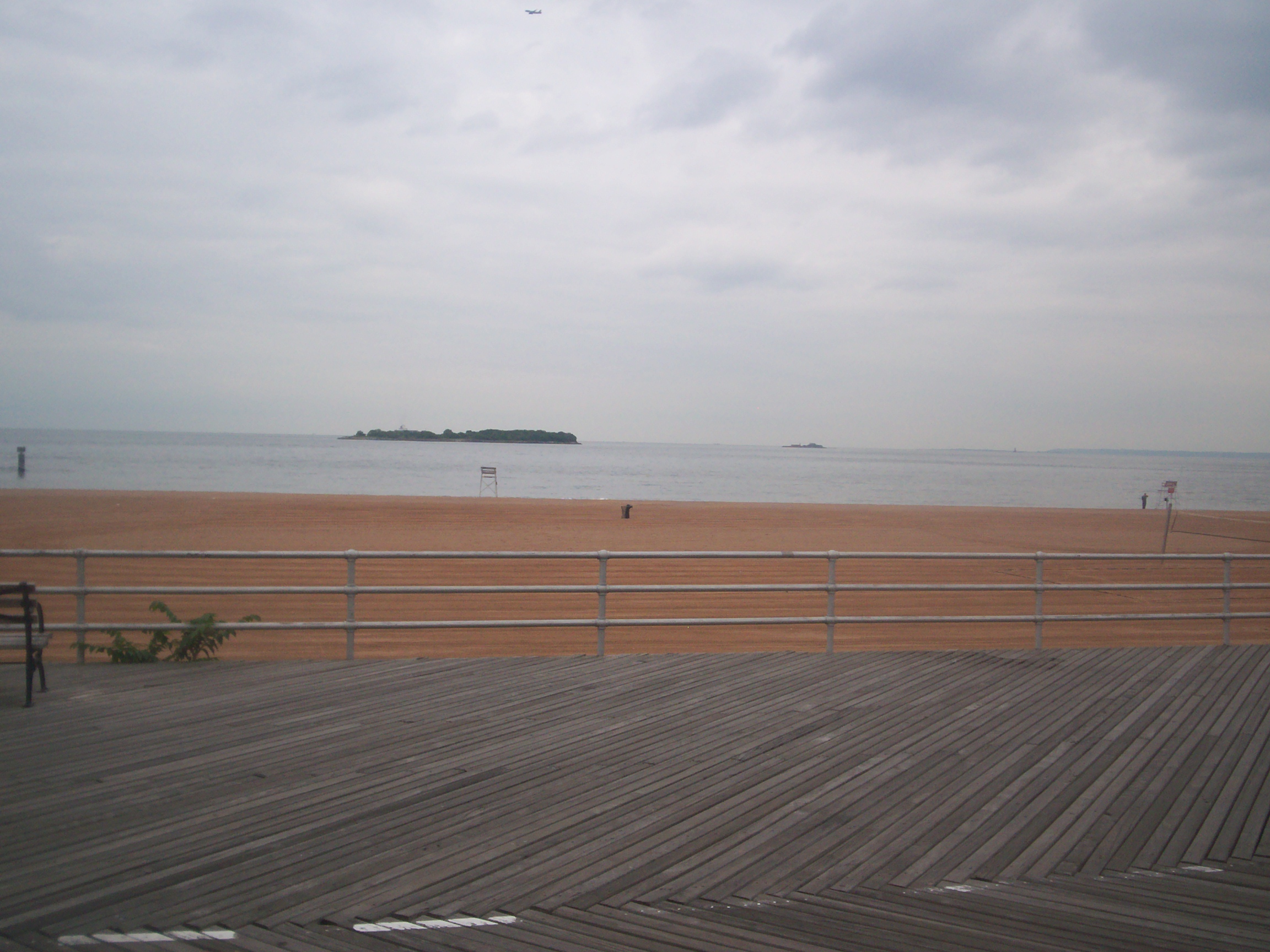
I asked Orton where he thought the city’s next island might appear, which felt a little like asking a brain surgeon I met at a party about my cat’s health problems. He thought about it for a moment and soon, he was scrolling through a map of the city, sharing his screen on the video call. We looked at Two Tree Island, and Sandy Hook in New Jersey, and then poked out towards the eastern end of Fire Island, where Superstorm Sandy had reopened an old inlet, splitting the barrier island in two. Finally, he returned to Rockaway, dragging the screen west and pausing at Breezy Point — a reclusive, private community at the tip of the peninsula.
“If there’s a hurricane, and you breach Jacob Riis right here,” he said slowly, running the cursor across the Marine Parkway Bridge towards the ocean, “then you’re going to have an island.”
Orton zoomed out, contemplating the prospect of Breezy Point’s island-ification.
“That’s a real possibility,” he went on, “because this peninsula is longer than it was in the 1800s, and much longer than it was in the 1700s, when it was small. It’s grown, and grown, and grown, and it’s trapped in place by a jetty, and you have this massive lobe of sediment at the end, but it’s not getting any wider at Jacob Riis, so it’s probably most vulnerable there. Maybe that’s my vote!”
It’s a little funny to imagine Breezy Point splitting off like that. The community is notoriously unwelcoming of visitors and uses everything from resident parking passes to literal gates to prevent strangers from poking around out there, effectively privatizing miles of pristine public beaches. It would, of course, be a great inconvenience for residents to suddenly find themselves stranded, but the neighborhood might come out the other side more itself than ever, with a natural barrier that reflects its attitude towards the rest of the city.
Many of the city’s islands are already closed off to human visitors, left to the wildlife that inhabits them seasonally. Ten heron species, as well as glossy ibises and double-crested cormorants nest on several of them in elaborate communities called rookeries. The birds build networks of hefty stick-nests in neighboring tree branches — the raucous, avian equivalents of apartment buildings — dividing the city’s island real estate up between groups of species that can tolerate nesting around one another. Even little U Thant, with its single dead tree and the sagging remains of an aluminum tower, hosts a double-crested cormorant rookery each year. In November, when the birds have departed, harbor seals and gray seals begin to haul out on Hoffman and Swinburne Islands, as well as a few of the rocky protrusions off of Pelham Bay Park, to wait out the cold before heading north again in March. As recently as the late 1980s, many of those animals were virtually absent from the city, and their return is a testament to the ecological value of undisturbed, isolated habitat (as well as the success of environmental initiatives such as the Clean Water Act).
New York islands have cycled through different uses, and the ruins they host still testify to their past lives, even if we’ve mostly forgotten them. On North Brother Island, where Typhoid Mary lived out her final days in isolation, a network of handsome sanitariums and hospitals is slowly sinking into a mass of poison ivy and porcelain berry. On Swinburne Island, a chimney rumored to be from the crematorium where cholera victims were burned still pokes above the canopy.
On inhabited and accessible islands, the historical buildings have been absorbed by functional neighborhoods and parks. Old bulkheads and docks from Jamaica Bay’s maritime past still jut out from the sand along the edges of Floyd Bennett Field (formerly Barren Island), where fishermen sometimes climb to add a few feet of elevation to their casts. Roosevelt Island, today home to nearly 12,000 New Yorkers, has offered itself up at various moments as a quarry, a pasture for livestock, and a place for prisons, smallpox quarantines, and mental health treatment facilities. Some of the old architecture is still around, including a gorgeous lighthouse from 1872, designed by James Renwick, Jr., the architect behind St. Patrick’s Cathedral. On the other end of the island, in what is now a state park, you can see the creepy gothic ruins of a smallpox hospital, also designed by Renwick. At night, when the hospital’s exterior is lit up, the empty windows stare across the East River like eye sockets of an enormous skull.
Roosevelt is the most populated of the city’s smaller islands, and in addition to the handful of centuries-old brick and stone buildings, it has the kind of charming hodgepodge of architectural styles and periods you’d expect to see on a college campus. Brutalist 1970s apartment buildings hulk over the glass offices, labs, and classrooms opened by Cornell Tech in 2017. A luxury apartment complex called The Octagon, which boasts a private outdoor pool and an exercise room, bills itself as “an oasis . . . of creature comforts and limitless opportunity on Roosevelt Island.” It takes its name from an eight-sided stone rotunda built in the 1830s around which its newer residential blocks are arranged. The marketing copy on the website leans into the old building’s shape, advertising something called “the 8 Points of Balanced Living,” but skips the provenance of the five-story octagon, which is the only surviving wing of the long-defunct New York City Lunatic Asylum.
But the lifestyle gibberish on the Octagon’s website also speaks to the real possibility of renewal for some of the islands with less-than-savory pasts as hiding places for the city’s crueler, more shameful functions. The prisons, asylums, and quarantine hospitals on Roosevelt Island (for a time, there were as many as 26 in operation there), have all been decommissioned over the years. Today, the island’s proximity to the United Nations Headquarters makes it a popular place for UN staff to live, and every morning, translators, diplomats, and other workers from around the world crowd into a cable car to cross the East River and descend on 59th Street in Manhattan. Along the way, they pass the car going in the other direction, which carries nurses, doctors and administrators employed by the Coler Specialty Hospital, a chronic care facility on the north end of the island.
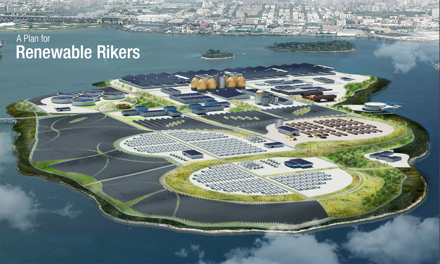
If New York has been trying to break its habit of using islands as prisons, Rikers Island, a 400-acre complex of city jails just north of LaGuardia Airport, is the glaring exception. Over 6,000 New Yorkers are currently held there, and conditions recall the worst days of the city’s 19th-century carceral islands and quarantines. Reports of people being confined in feces-soiled showers and overcrowded intake cells, denied essential medical care, beaten, stabbed, and otherwise harmed and degraded by staff and other people incarcerated on the island are common. In theory, the jails there are also set to be decommissioned by 2027, and a few dozen acres have already been ceded to the Department of Citywide Administrative Services. Legislation passed by the City Council in 2021 put in motion a plan to convert the 400-acre island into a renewable energy hub, with battery storage, solar energy capture, upgraded sewage treatment facilities, and organic waste processing.
Governors Island, which was controlled by some element of the US military between the Revolutionary War and 1995, is being similarly enlisted in the fight against local environmental issues. The city, which bought the island in 2003, plans to build a Climate Exchange there, envisioned as an institution where nonprofits and universities can collaborate on solutions to problems caused by climate change. Since opening to the public in 2005, the grounds have already become a popular attraction, with year-round ferry service from Brooklyn and Manhattan. On summer weekends, lines for the ferries can stretch for blocks, as New Yorkers wait to get to an island a few thousand feet away.
Looking at Two Tree Island, with its little moat all filled up at high tide, it was hard to imagine any serious implications of it splitting off for good. A few people might lose a fishing spot if the path was swept away, or a favorite sunbathing rock, but nobody’s life would be upended, or even really impacted. Aside from the little fish swimming around in the channel, nobody but me had even noticed.
When I asked Philip Orton what level of flooding New Yorkers should be ready for, he emphasized that people in Howard Beach were already experiencing flooding on a monthly basis, but hesitated on the bigger questions.
“I don’t know what to say. I mean the future? Jeez. It depends a lot on what the city does and what the Corps of Engineers does,” he sighed. “The thing that strikes me all the time is there’s a lot of elevation in New York City that’s above twenty feet, and above fifty feet, so we can talk all we want about low-lying neighborhoods, but in the end the city is not facing an existential crisis like Miami or somewhere like that.”
Existential is, I guess, a relative term. If AdaptMap was Orton’s way of trying to look at the problem clearly, I guess counting islands is my way of shrinking it down to something I can understand. In Broad Channel, a neighborhood on one of the inhabited islands that gets standing water whenever there are strong winds, some residents mark lines on the walls of their homes to record the high-water marks from storms that were big enough to get past their front doors.
The views expressed here are those of the authors only and do not reflect the position of The Architectural League of New York.


#/media/File:North_Brother_Island_from_Barretto_Point_Park.jpg)
#/media/File:Welfare_Island_Insane_Asylum_EAST_SIDE_HABS_NY,31-WELFI,6-1.jpg)
Comments