

.jpg)
Series
Cleaning Up?
An exploration of what it means to live in, build on, and design for a city of pervasive toxicity.
We are celebrating 15 years — and counting — of stories that are deeply researched and deeply felt, that build a historical record of what the city has been.
Our special series Cleaning Up? takes up the critical role of remediation in a toxic urban environment. But why are we suggesting cities are toxic to begin with? Below, Scott Frickel, a sociologist and scholar of the politics of environmental knowledge, starts us off with a survey of how industrial land uses spread across cities and neighborhoods — and how awareness of them disappears as businesses and residents come and go. Factories become apartment buildings, bakeries, and even preschools, while residual contaminants linger in the soil and water below. There’s a vast and largely unidentified landscape of such hidden hazards across American cities, far beyond the scale of high-profile redevelopment sites like those along the Gowanus Canal in Brooklyn or at Hunters Point in San Francisco. But because these sites are crucial to calculations of green-tinted growth, most measures to address contamination begin and end there. In the second part of his essay, Frickel looks at the mismatch between the remedies that cities, states, and the US Environmental Protection Agency employ to address toxic conditions, and the true nature of the problem. Most importantly, he proposes how we could approach environmental remediation otherwise: not as a tool for inequitable redevelopment, but as an instrument of environmental justice. – MM
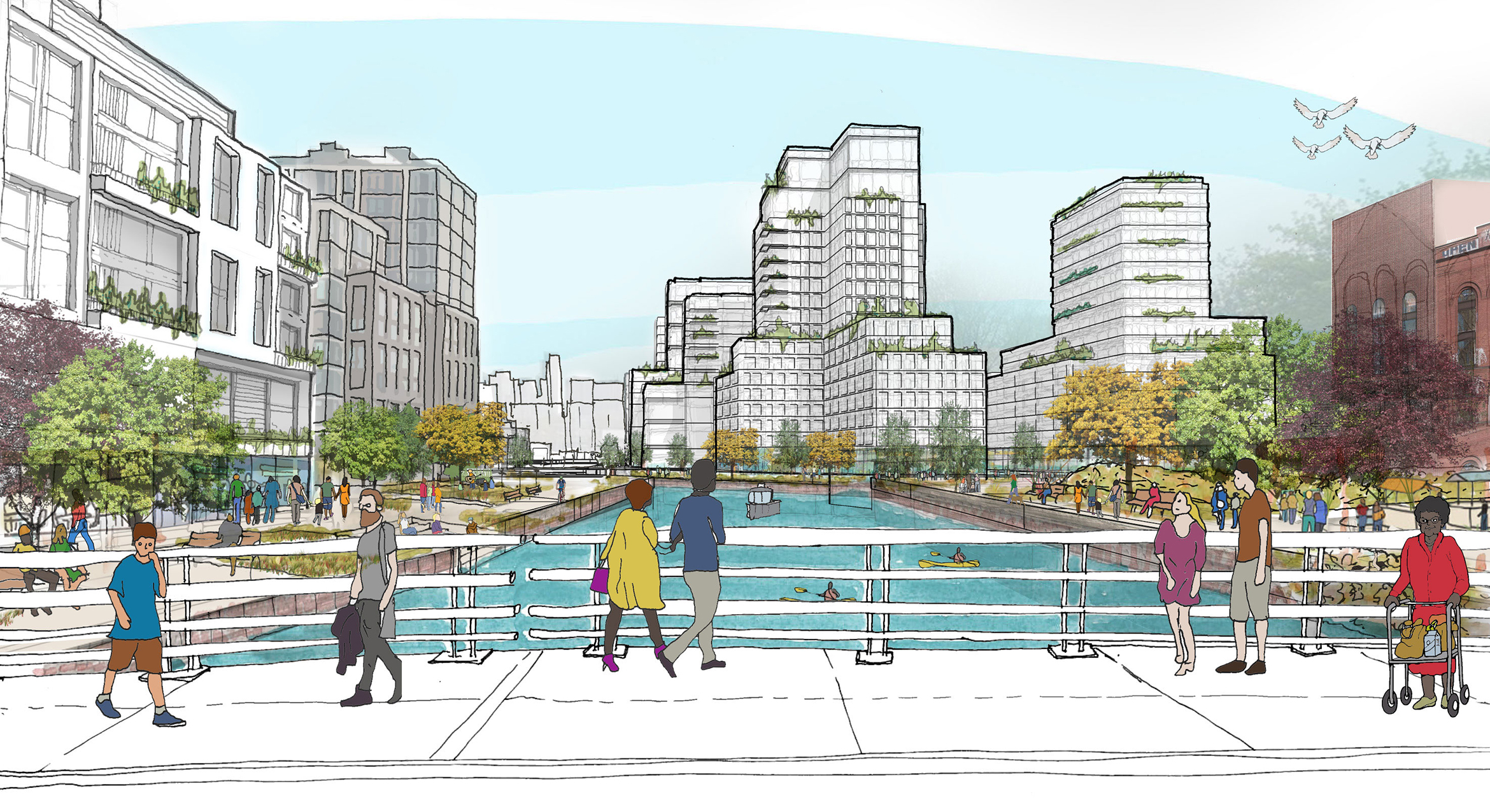
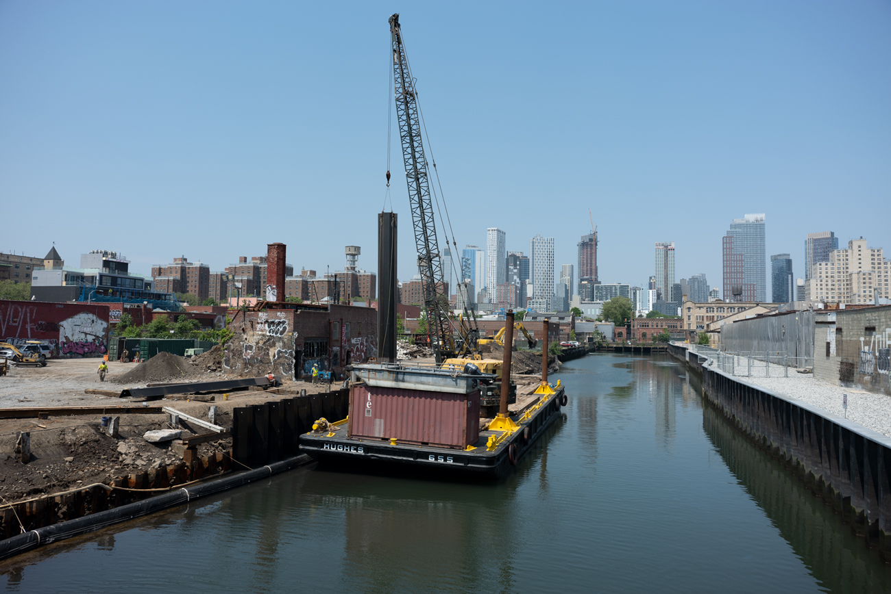
“What does it mean to remediate a toxic urban landscape?” To even ask the question is to grapple with two important yet incongruous ideas: that cities are “toxic”; and that detoxification, by getting rid of the chemical and other industrial hazards that have long accumulated in cities, is somehow possible. These ideas push us to think critically about what remediation can and cannot accomplish and about what we should or should not expect from the municipal, state, and federal agencies responsible for “cleaning up” hazardous sites — like those along Brooklyn’s Gowanus Canal.
Currently in the midst of a high-end facelift, the various remediation and redevelopment projects underway along the Gowanus implicate a powerfully coordinated urban growth machine: those coalitions of bankers, realtors, urban planners and city government officials which direct large-scale redevelopment projects toward economic growth, often over community interests. This growth machine is self-consciously focused on “green gentrification” and deeply committed to a market-oriented approach to building new “sustainable” communities.[1] Proponents celebrate the projects’ future potential for increasing municipal tax bases and promoting urban “livability,” while critics point out that existing social and environmental inequalities are likely to deepen for current residents in the wake of these projects.[2]
Pro or con, both views highlight specific high-value parcels, the remediation of which promises huge payoffs for investors and new opportunities for consumers. But both groups also miss — or at least underplay — the fact that urban toxins have been accumulating in cities for the longue durée and that the resulting contamination of urban soils is not limited to any specific site but occurs extensively across urban landscapes. While important and current, perspectives on redevelopment that frame urban toxins as a contemporary problem — to be barreled through toward an imagined, greener future — obfuscate the already barely visible historical processes that have produced and spread hazardous wastes incrementally and unevenly across urban environments for centuries. The historical and spatial dimensions of urban industrial wastes are crucial for grasping the larger nature of the problem that remediation claims to fix.
The chemical legacies of industrial development remain long after the factories and shops which release pollution have shuttered and gone. Lingering contaminants include a wide range of compounds: from industrial heavy metals such as lead, cadmium, and zinc; to organic compounds which originated in laboratories, such as PCBs or PFAS (also known as “forever chemicals”); and still other byproducts of industrial production, like coal tars or petroleum aromatic hydrocarbons. Released into the environment, contaminants often mix in higher or lower concentrations and can be more or less toxic and more or less bioavailable for uptake by living organisms — including nearby workers and residents. Misidentifying urban toxicity as a problem plaguing individual sites helps ensure that government efforts to deal with the mess are inadequate. In this context, history and geography can serve as antidotes to the narrow presentism of urban planning and growth machines.
We can begin by asking, where do toxic urban landscapes come from? In our book Sites Unseen, urban sociologist James R. Elliott and I tried to answer this question by examining changing industrial land use patterns in four cities — Philadelphia, Portland, Minneapolis, and New Orleans — over five decades, from the mid-1950s to about 2010. That longer timeframe allowed us to study the larger dynamics of urban land use and reuse unfolding gradually over time and space: a process, common to all cities, that we call “socioenvironmental succession.”
This is a fancy term, but the ideas behind it are commonplace. We borrowed the root concept of “succession” from field ecologists working in the late 19th century. They used the term to describe how small-scale, localized changes build on top of one another, with each change reinforcing changes that came before and shaping possibilities for future transformations to come. Over time, many localized changes collectively create broader, system-wide patterns. This is how meadows eventually become forests. Successive change becomes “socioenvironmental” when we apply the concept to cities. Here, it involves not just nature, climate, and geography, but people, institutions, and built environments interacting with one another and with nature. Applied to the problem of urban toxins, socioenvironmental succession explains how industrial wastes are buried, dumped, sunk, impounded, injected, and scattered across an expanding roster of industrial sites, lot by lot and year after year. Over time, these small changes create ever-larger “landscapes of exposure” in and around the same neighborhoods where city residents continue to live, work, and play.[3]
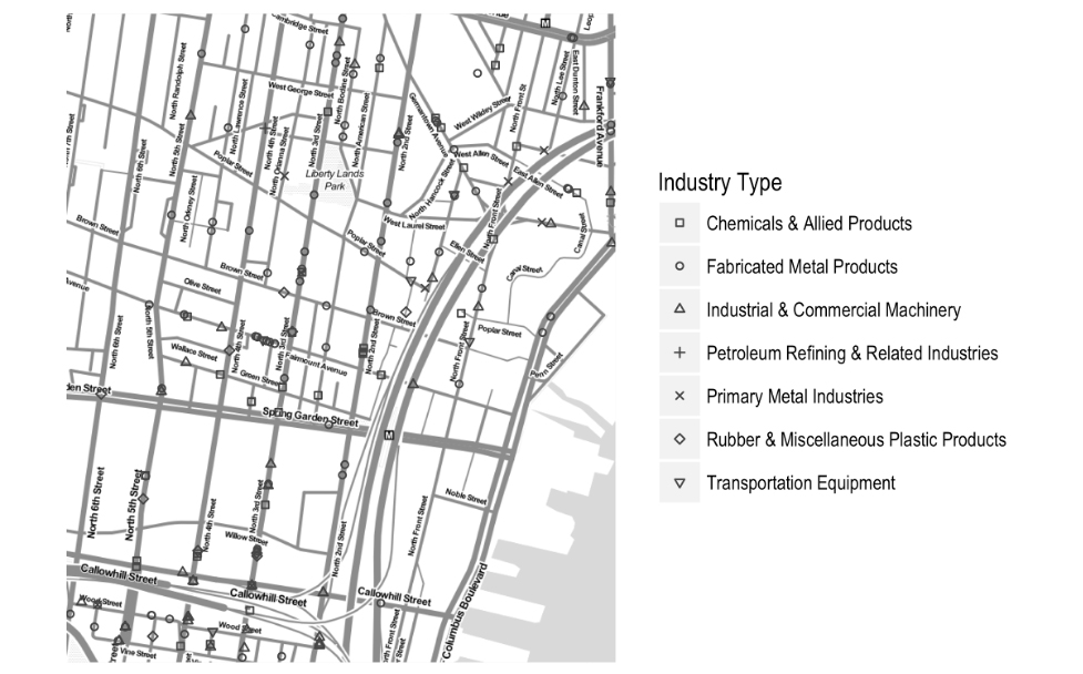
The information we gathered documents socioenvironmental succession as it has unfolded in real time, gradually but relentlessly. A snapshot from one Philadelphia neighborhood illustrates why a historical and spatial perspective on industrial land use — and the remediation that, occasionally, precedes redevelopment and reuse — is so important.
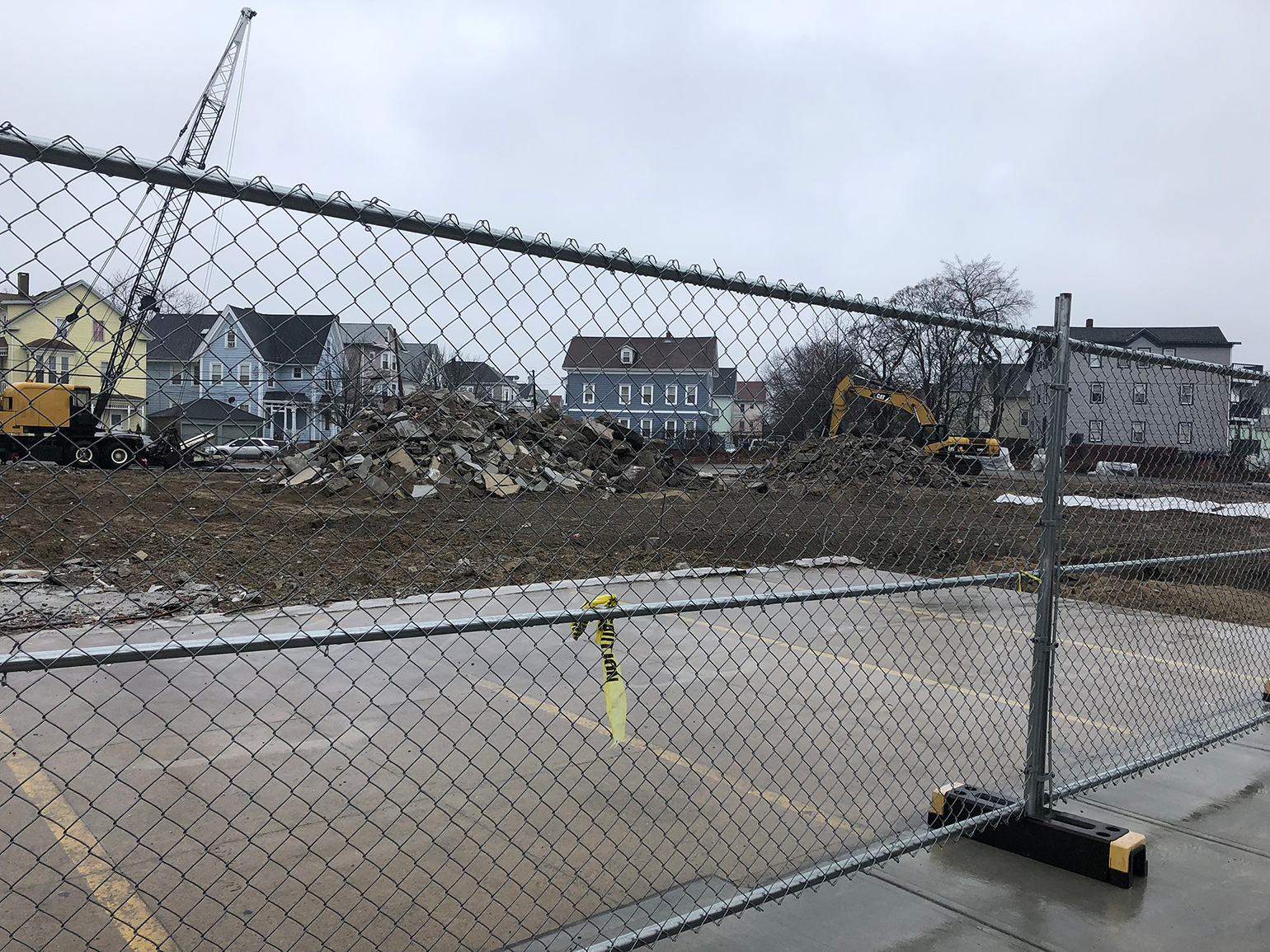
Situated just north of Philadelphia’s central business district along the banks of the Delaware River, an old manufacturing area called Northern Liberties is booming . . . again. But this time, it’s not the factory whistles blowing from the nearby J.E. Lonergan Company (steam valves and other locomotive parts and lubricants), the American Can Company (yes, tin cans), or the Rohm & Haas Company (synthetic chemicals and dyes) that draw workers and their families to the area. Today instead bistros and gastropubs, art galleries and boutique shops linked by a newly developed walking mall and public plaza attract a very different — significantly wealthier and comparably whiter — group of residents to “Nolibs.” A two-acre community-developed garden space and children’s playground dubbed “Liberty Lands” sits atop a . . . site once occupied by the Burk Brothers Tannery. Described by local boosters as “a hotbed of enviro-friendly construction” designed to complement “ambitious mixed-use complexes that reimagined overlooked industrial bones,” the rapidly gentrifying neighborhood is trading heavily and, it seems successfully, on its industrial past.
. . . In 1956, when our study period begins, the neighborhood’s streets would have looked, smelled, and sounded much different. For one thing, at that time there were 97 manufacturing facilities operating here, crowded onto a 1.5 square-mile patch of densely settled urban land. Between the 1950s and 2017, deindustrialization hit the Northern Liberties area and adjacent neighborhoods hard, but it did not keep new hazardous manufacturers from opening and closing, [as the map below] partially shows. Our data indicate 224 relic sites by 2008 — a number 37-times the number of currently operating sites and more than twice the number operating in the mid-1950s . . . [This adds up to] more than five hundred former sites of hazardous manufacturing per square mile, which, if distributed evenly over space, would yield a relic site every ninety yards.
(Excerpted with permission from Sites Unseen: Uncovering Hidden Hazards in American Cities by Scott Frickel and James R. Elliott.)
While the density of relic industrial lots in Northern Liberties represents a relatively extreme case in context of the cities we studied, this example likely pales in comparison to many neighborhoods in New York, where the scale of 20th century industrialization, and pace of 21st century redevelopment, have been, in turns, ferocious. On the other hand, Northern Liberties illustrates trends common to all four of our study cities, suggesting that similar patterns shape other urban areas across the US. Boiled down to its essentials, our research holds four general lessons.
The first and most basic lesson is that as industrial sites accumulate over time, they also spread out, increasing the amount of newly industrialized lands a city will generate. The absolute number of industrial facilities operating annually is remarkably stable (even accounting for decades of deindustrialization), while the number of former or relic industrial sites steadily increases. When new facilities open, they tend to occupy lots not previously occupied by other industrial establishments. To be sure, this dynamic is less pronounced in areas zoned for industry, but even there, the general pattern holds. As it turns out, zoning laws do a reasonably good job of preventing people from living within industrial areas, but they don’t work as well to keep industry from operating within residential areas. And, thus, a city’s footprint of industrialized lands – and whatever potential contamination of local soils, water, and air may accompany those activities – grows inexorably larger with every passing year.
The second lesson is that the steady accumulation of industrialized urban lands goes largely unrecognized because socioenvironmental succession hides what it creates. On average, manufacturing establishments operate for about eight years before closing down or moving elsewhere. Redevelopment pressures are such that most former industrial sites take on different functions and assume different looks over time. The vast majority become repurposed for a wide range of mostly non-industrial activities — from condos and offices to retail outlets and restaurants and many things more besides, including parks and preschools. Moreover, residents’ knowledge of earlier industrial land uses also dissipates as local populations turn over, erasing a community’s sense of their neighborhood’s environmental history as buildings change and collective memory fades. The regularized churning of industrial lots and urban populations reinforces the tendency for socioenvironmental succession to cover its tracks.
If community members fail to recognize the broader, longer-term patterns of industrial changes in their neighborhoods, then it would seem that environmental agencies responsible for managing hazardous industrial waste must take up the challenge of cleaning up. Right? Wrong — or mostly wrong. In our study, we found huge gaps between the information that agencies routinely collect about the nature and volume of industrial waste, and the reality of manufacturing history and geography. This is the third lesson, and the one I find most concerning. As we discovered, fewer than ten percent of historically existing manufacturing sites appear on government agency brownfield lists or hazardous site lists. There are many reasons for this gap. The clear takeaway, though, is that more than 90 percent of industrial sites in operation since the 1950s (i.e. at the height of the country’s industrial expansion) do not appear on government hazardous site lists and related databases. We should not assume that all of these missing sites are contaminated, of course, but we also shouldn’t assume that they pose little or no environmental threat. The truth lies somewhere in between these two extremes.
The final lesson follows from the previous three: Former industrial sites that environmental agencies, urban planners, developers, and banks invest in and prepare for redevelopment — and thus are legally obligated to investigate and, if warranted, remediate any legacy hazards discovered — represent a fraction of potentially contaminated urban lands. We conducted statistical analysis to find out which characteristics of former industrial sites and their surrounding neighborhoods best predict whether sites appear on public hazardous site lists. Perhaps not surprisingly, it is “charismatic megasites” such as Gowanus Green or Liberty Lands — featuring larger, older, factories that have shuttered since the 1980s — that have the highest chance of attracting regulatory attention. Yet even then, the probability is less than ten percent that such large and visibly risky “eyesore” sites will attract the investigative resources of environmental agencies.
Precious few historically existing industrial sites, small or large, ever undergo actual remediation. Those that do — especially capital-intensive, high-visibility projects that attract media headlines and public controversy — are exceptional cases. They tell us little about the nature of the vast yet uneven landscape of industrialized soil and water underlying many American cities, one whose scale and scope we are only now beginning to better understand and appreciate.
If urban landscapes are indeed toxic, then what does it mean to remediate them? Is remediation — as conceptualized, organized, financed, and practiced in the United States today — a solution to the problem of toxic urban landscapes, or a basic feature of the problem itself? At the US Environmental Protection Agency (EPA), the term remediation is generally synonymous with the idea of “site cleanup.” But the word has more nuanced roots. It is derived from the Latin noun, remedium, which has three distinct, but related, meanings, drawn from language around human health:
1. “remedy, cure”
2. “medicine”
3. “aid, assistance”
Applied to the contemporary city, these Latin definitions point to a more constructive and multidimensional understanding of the politics of environmental remediation:
1. What is the malady that environmental remediation seeks to “cure”?
2. What kind of “medicine” does environmental remediation offer and how well does it work?
3. Who receives the “aid” that environmental remediation provides, and who does not?
If remediation is the official promise of a cure, the patient is contaminated land. Since 1980, federal legislation has made landowners responsible for investigating and cleaning up contaminated properties and has made those determinations requisite for the subsequent transfer of land title. Within this legal-economic framework, the problem of contaminated land — what it is, how we know, and what we do about it — is an increasingly important axis on which the wheels of urban development turn or stall.
“Is this soil contaminated?” turns out to be a complicated and highly consequential question. Which contaminants are present, in what form, and at what levels and bioavailability? Finding the answers and fitting them together in site investigation reports and, ultimately, a “record of determination” (formal documents dictating remedial measures to be taken) can take years. These tasks, and related measures, fill the daily work routines of environmental scientists and engineers at state and municipal environmental agencies in cities and towns across the United States. The question has also spawned a large and growing national industry, projected to reach a market value of $38 billion by 2025.[4] International environmental and energy services corporations such as Bechtel, BRISEA Group, and Veolia North America dominate the industry. At the local level, small- and medium-sized law firms, real estate businesses, construction companies, banks, environmental testing laboratories, and engineering firms compete for pieces of the action. Their individual and collective decisions (and non-decisions) generate shared understandings of contamination and drive site-specific remediation planning that in turn guides subsequent action (or inaction) on individual parcels of land.
Conducted in the name of environmental protection and public health, most of this work plays out in quasi-public or private settings where interests in the successful conclusion of property transactions are high and nearly universally shared. Ostensibly, the actors involved all stand to benefit — financially and politically — when city property is bought and sold. Consequently, the incentive structures for finding and cleaning up contaminated industrial lands would seem to favor a “less is more” logic and invite behavior that minimizes the scope and scale of industrial urban wastes, on and off particular sites.
Just as socioenvironmental succession drives the incremental accumulation of industrialized lands, with each site assessment, the remediation industry similarly lubricates real estate markets and urban planning, revalorizing “wasted” lands and indelibly shaping the future of cities by determining which lots in which neighborhoods will reckon with the chemical legacies of the past and which will not. In this way, the remediation industry inscribes the science and policy of contamination onto cityscapes, shaping urban struggles for environmental justice.
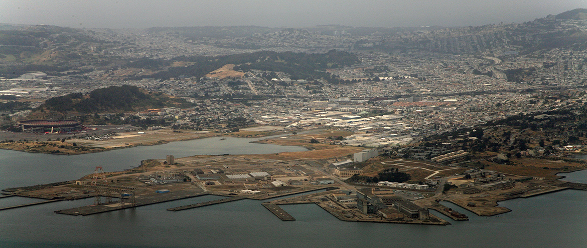
Most of us could probably agree that not cleaning up heavily contaminated urban land is a bad thing. But is cleaning up necessarily good? And if so, for whom is it good? There is mounting evidence that site cleanup can have negative effects and exacerbate environmental injustices. The very process of “cleaning up” can further contaminate neighboring residential areas, while also raising neighborhood property values and displacing lower income residents. Both of these consequences are on view in the redevelopment of Hunters Point Shipyard in South San Francisco, where remediation of radiological and chemical contamination exposed site workers to cancer-causing wastes and sent poison dust drifting through the surrounding African American community — residents who are now facing rising property values and are at risk of dislocation.[5]
If combatting urban-scale toxicity instead requires something closer to urban-scale remediation, what would that look like in practice? City governments, in collaboration with local communities and civic institutions, would foremost need to balance public health and safety with ecological wellbeing by actually cleaning up contaminated sites. More and more, “remediation” involves containing industrial waste on-site and closely managing persistent risk rather than physically removing it or otherwise chemically reducing its toxicity or bioavailability. Engineering values and mindsets dominate in this world. Retention walls, monitoring wells, geotextile fabrics, topsoil caps, chain link fences, and “No Trespassing” signs are some of the standard tools of the trade. Designed to keep people away from contaminated spaces as a strategy to minimize public exposure, these tools are less typically designed to protect or rehabilitate urban ecosystems. For example, monitoring wells can tell regulators when a plume of contaminants moving underground reaches groundwater, but they probably won’t protect clean groundwater from saturating and mobilizing contaminated soils when rising sea levels and storm surges push water tables higher. A first principle should be: remediate from the bottom up, as if nature mattered.
Cities would also need to ratchet up the pace of remediation. Socioenvironmental succession is not just something that happened in the past: It is an ongoing process. The hazardous sites of today — whether larger manufactories, smaller metal fabrication shops, or corner gas stations — will become the brownfields, and then office buildings and preschools, of tomorrow. Slow-walking remediation puts cities further and further behind. Funding a public workforce, deployed to ramp up remediation activities, along with investment in developing remediation technologies as a key infrastructure, could be first steps.
Cities would need to reconsider individual sites as the focus for remediation. Site-based remediation ignores the scale of toxic hazards that socioenvironmental succession creates as industrial activities churn across urban landscapes and as legacy contaminants are pushed “off-site” by wind, soils, and water, unconstrained by the legal fiction of property boundaries. In sum, site-based approaches are the wrong scale and are disconnected from urban ecosystems. Watersheds are probably better frameworks for organizing remediation than individual sites or city blocks.
Finally, cities must decouple remediation from real estate markets. This is a tall order. But, when remediation is governed by the logic of property sales, inequities get baked into the system. Without broader systemic change, remediation will concentrate in hot markets and diffuse in cool markets, ensuring new forms of environmental inequality that distinguish, for example, poor-but-developing neighborhoods from areas of entrenched poverty and institutional neglect. Adding contaminant testing for heavy metals and organics to urban soil surveys such as those compiled by the US Department of Agriculture’s National Resources Conservation Service or the Urban Soils Institute could provide a knowledge base for decision making about which neighborhoods, in which watersheds, to prioritize for equity-conscious remediation planning and execution.
None of these actions are cheap or easy. But they begin to address the real limitations of our current regulatory system to track, find, and remediate historical industrial hazards. For the most part, agencies do not do what environmental laws do not require, and nothing currently requires agencies to address the true nature and scope of toxicity in urban landscapes driven relentlessly onward by socioenvironmental succession. Wrapped inside the property logics of real estate markets, most regulatory systems leave far too much decision-making power to the growth machines and provide far too little public oversight that is independent, transparent and consistently applied. In this way, lost sites, if found, are all too often lost again.
John R. Logan and Harvey L. Molotch, Urban Fortunes: The Political Economy of Place (Berkeley and Los Angeles: University of California Press, 1987); Kenneth A. Gould and Tammy L. Lewis, Green Gentrification: Urban Sustainability and the Struggle for Environmental Justice (Abingdon and New York: Routledge, 2017).
Melissa Checker, The Sustainability Myth: Environmental Gentrification and the Politics of Justice (New York: NYU Press, 2020).
Gregg Mitman, Michelle Murphy, and Christopher Sellers, eds., Landscapes of Exposure: Knowledge and Illness in Modern Environments (Chicago: University of Chicago Press, 2004).
Key MacFarlane, “Time, Waste, and the City: The Rise of the Environmental Industry,” Antipode 51, no. 1 (January 2019): 225-247.
Lindsey Dillon, “Race, Waste, and Space: Brownfield Redevelopment and Environmental Justice at the Hunter’s Point Shipyard.” Antipode 46, no. 5 (November 2014): 1205-1221.
The views expressed here are those of the authors only and do not reflect the position of The Architectural League of New York.
An exploration of what it means to live in, build on, and design for a city of pervasive toxicity.