We are celebrating 15 years — and counting — of stories that are deeply researched and deeply felt, that build a historical record of what the city has been.
We are celebrating 15 years — and counting — of stories that are deeply researched and deeply felt, that build a historical record of what the city has been.
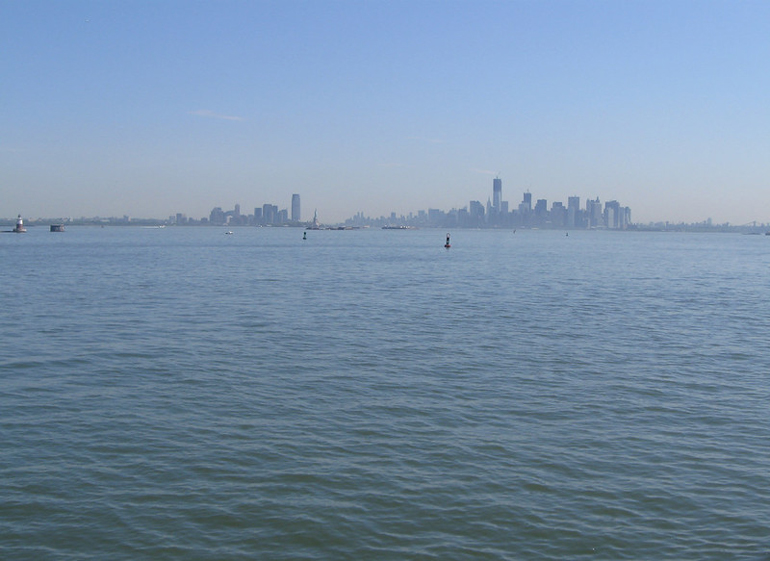
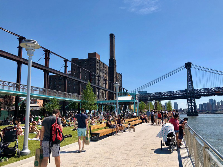
With the exception of the Bronx mainland, New York City is an archipelago of islands large and small (the exact number of which is still a matter of debate). The inverse of all those masses of land, of course, is the water that surrounds them: rivers, creeks, harbor, bay, ocean. If an island consciousness has been on the rise in recent years, it would certainly be incomplete without an appreciation for how the city’s relationship to water has changed over time. Once primarily the domain of heavy industry and shipping, the city’s shores have evolved into some of its most celebrated cultural “amenities,” too, stoking the imaginations of developers and planners.
Whether as a site for a shipyard or a park, New York’s waterfront has long been at the leading edge of visions for the city’s future. Yet it holds significance beyond the prerogatives of logistics and leisure. Water ties people to landscapes past the city’s limits, and to the natural substrates of its urban fabric; it connects them to ecologies that are more than human and histories that complicate (or even refute) “progress.” Works on Water is an arts organization committed to exploring these enigmatic relationships through creative practice. In collaboration with the Department of City Planning — the agency developing a new waterfront plan to be released this year — Works on Water, along with Culture Push, launched a unique participatory project called Walking the Edge. Initially conceived as a relay along the city’s 520 miles of coastline, the project, which runs through September, has been pushed in new directions due to the pandemic. Taking place as much on Instagram as along the waterfront, this shift has led to rich artistic contributions of a whole different sort. Below, Nicole Miller illuminates the program’s unconventional trajectory, while considering the role that a different “edge aesthetics” might play in reframing New Yorkers’ sense of the city we make on water and land alike.
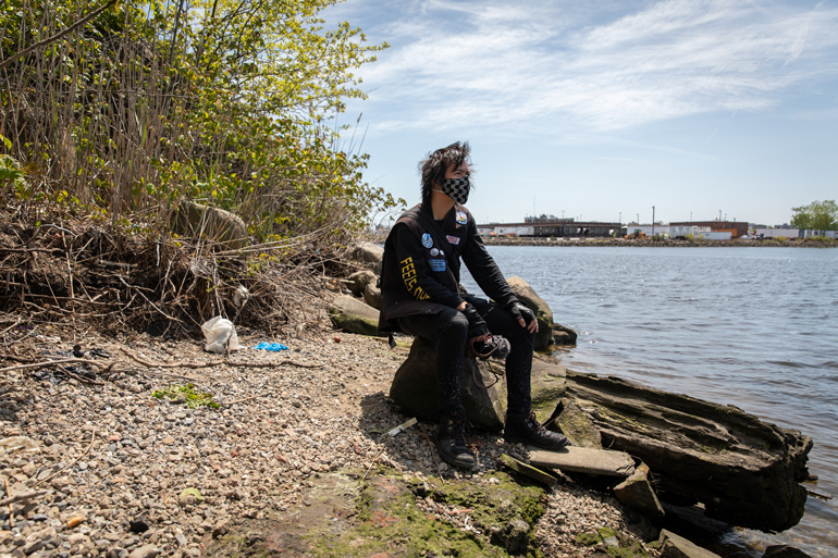
When Simone Johnson was growing up on the North Shore of Staten Island in the early 2000s, she could see New York Harbor from the fifth-floor apartment where she lived with her grandmother. She remembers a footpath along the shoreline and the rocks that led down to the water. She walked steep hills to get to the Snug Harbor Cultural Center, where she volunteered at Heritage Farm. “St. George is in my body,” she told me, “because I walked it so much.”
Johnson has always had a love-hate relationship with Staten Island — often viewed by New Yorkers as “a place that doesn’t belong to the city.” Taking the ferry to Manhattan almost every day to attend dance classes or school, she loved being out on the water, but felt cut off from other parts of city life. “I feel like my whole life has been lived on some edge, not really belonging anywhere.” Now an artist who lives in New York City only part-time, Johnson remembers when the North Shore began to get a makeover. About ten years ago, real estate developers proposed building an enormous Ferris wheel on publicly owned land in St. George. In 2013, the New York City Council approved plans for the New York Wheel and an adjacent outlet mall promising 125 retail stores, a hotel, and restaurants. Empire Outlets opened in May 2019, and today, over half of its retail storefronts remain empty; while original plans for the New York Wheel also foundered, leaving behind a concrete base and parking garage, a new, scaled-down proposal is reportedly in the works.
“Our waterfront was completely taken over,” Johnson told me. “Staten Islanders have all these ideas for the waterfront, and they’re obviously not being listened to, because somebody dropped that mall there.” She told me about her community’s unrealized visions for the waterfront, which include the Staten Island Urban Center’s proposal for a maritime education, recreation, and cultural corridor along Bay Street. But when the city rezoned the Bay Street corridor last year for residential and commercial uses, it paved the way for high-rise development. Locals and elected officials who opposed the rezoning plan were concerned about insufficient investment in affordable housing and infrastructure, as well as lack of open space. As Johnson put it: “I just don’t understand building giant structures on the waterfront so you obscure the view.”
If Staten Islanders are concerned about privatized views of the water, perhaps it’s because they’ve been encouraged to think of their waterfront as primarily a visual amenity. Waterfront views were the main selling point of the New York Wheel; Empire Outlets also boasts a waterfront walkway and views of the water from its food court and shops. And while views from the city’s shores have been sold as global commodities, images of the edge also play an important role in how New Yorkers see themselves.
In recent decades, New York’s waterfront has been transformed from a once obscure site of clandestine activity — think Prohibition-era rum-running, or gay cruising along the West Side piers — to a visible icon of surveillance capitalism (marked by glass panopticons wired for collecting data) and corporate resilience. New development is maintained in part by restored wetlands from Jamaica Bay to Hunter’s Point, where soft edges and salt-tolerant plants normalize disaster, preserving power structures that created the climate crisis. While the global city enjoys expanded waterfront vistas, its point-of-view has shrunk toward a single perspective: that of the overseer.
In practical terms, waterfront development is guided by the Comprehensive Waterfront Plan, first published in 1992 by the New York City Department of City Planning (DCP). Updated every ten years, the document establishes land use policy for the city’s waterfront, including parks, housing and economic development, transportation, recreation, and shoreline habitats. Vision 2030, forthcoming later this year, promises to make New York’s waterfront “more accessible, active and resilient.” But how the island dweller relates to the waterfront also depends on how the edge addresses us as subjects and appeals to our imaginations. How does the aesthetic construction of the waterfront shape our ideas about what the city is, what it can be, and who it’s for?
Works on Water (WoW) has been asking these questions since it formed in 2017. A collective of New York City-based artists working with water as a medium or site, WoW sees the urban waterfront as a vital nexus of ecologies, where the artist might address complex bio-cultural systems through collaborative, interdisciplinary methods. Since its inaugural Triennial exhibition in 2017 — featuring artists working on, in, and with New York’s waterways — WoW’s initiatives have included an artist residency on Governors Island (which I helped coordinate in 2018 with partner organization Underwater New York) and a Waterfront Planning Camp last year, co-hosted with DCP. At the time, DCP’s Waterfront and Open Space division was in the early stages of developing Vision 2030. At the day-long, interactive event on Governors Island, city planners and WoW asked participants to imagine the future of the waterfront.
Their collaboration culminated this year in Walking the Edge, a program created by WoW and arts non-profit Culture Push with DCP. Designed to coincide with DCP’s comprehensive waterfront planning process and the Works on Water 2020 Triennial, Walking the Edge was intended to be “a trailblazing urban planning initiative and a spectacular, progressive public art work, casting New Yorkers as both public artists and civic researchers.” Initially, this meant a month-long, continuous relay along all 520 miles of New York City’s shoreline. According to WoW co-curator Sarah Cameron Sunde, Walking the Edge organizers hoped that a large-scale, participatory event would bring public attention to the waterfront, making it a major topic and priority in the upcoming mayoral election.
More tellingly, the project’s aim to unite research and creative practice signals an emerging role for artists in civic space. Increasingly, artists working through social engagement and performance are engaging with public policy and working to facilitate public dialogue and build consensus or coalitions. “I am always really wary of having my practice instrumentalized by power,” WoW co-curator Nancy Nowacek told me. “Often, when city processes go awry and people cry out, artists are brought in to make nice with communities.” But WoW’s partnership with DCP, she followed, reflects a shared desire to invite New Yorkers to think about their relationship to the water.
When Walking the Edge debuted in May, the coronavirus pandemic had ruled out the possibility of a public procession. Instead, the project offered a simple invitation to New Yorkers under lockdown: “Take a virtual or actual walk to your nearest waterfront, your closest edge.” Throughout the summer, commissioned artists provided weekly prompts or questions on social media, inviting various publics to examine the city’s shoreline by memory, map, or on foot. “Initially, we were thinking about walking the edge to connect those 520 miles of shoreline, but in this adapted version, we were thinking about walking to the edge, which raises a different set of questions,” Associate Waterfront Planner Lucre Montemayor told me.
The project’s revised approach transforms the concept of an edge from a single, continuous line to the fractured segments of individual circumstance or desire. Departing from the collective relay route, a public performance with a shared script, to a virtual format loosens the institutional controls often imposed through civic participation. Its expanded definition of walking — “moving through space with attention and intention” — takes into account the different mobilities of those quarantined at home or with disabilities. Rather than addressing a universal public, the project makes an expansive appeal to those cut off from the water by social, political, and economic infrastructures.
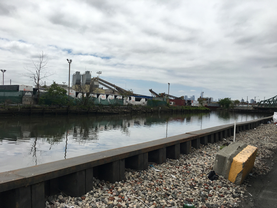
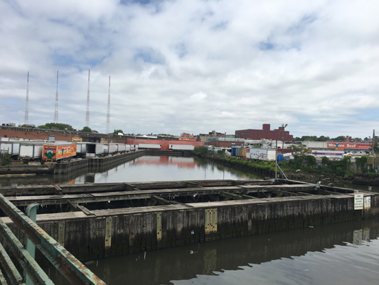
From my block in Brooklyn, the nearest waterfront is the cove north of Flushing Avenue occupied by the Brooklyn Navy Yard. On DCP’s Waterfront Access Map, which marks publicly-accessible sites in green, this area is gray. Moving clockwise on the map, Newtown Creek channels down into Brooklyn, its industrial waterfront also coded gray, except for a faint green line tracing the nature walk near the wastewater treatment plant. According to DCP, about 30 percent of the city’s waterfront is managed by the Parks Department; a smaller portion of privately-owned waterfront also provides public access as sites undergo development. Yet much of the map is gray.
According to DCP’s Deputy Director, Brendan Pillar, the city’s zoning regulations require most waterfront developments to provide a publicly-accessible waterfront space at the cost of the developers. But the dozens of new public access sites completed in recent years remain unequally distributed, he acknowledged, in part because those requirements don’t apply to sites where heavy industrial and maritime uses might conflict with public access. Newtown Creek, lined with oil refineries, chemical plants, and smelting works throughout the last century, remains mostly off-limits to pedestrians, according to the map. But for Walking the Edge organizers, encountering barriers to access is a central feature of the project, as it shapes our perceptions of the city.
I walk east toward the creek on a bright Sunday afternoon in May. Cutting through Herbert Von King Park, which is guarded by a masked NYPD officer, I head north on Tompkins Avenue, where the Pentecostal churches are closed and quiet. Ahead, there’s the dark bulk of Woodhull Hospital, a line of ambulances in its bay. I move up Flushing Avenue along a corridor of closed gates and high walls, then through the wholesalers, lumberyards, scrap metal dealers, and waste transfer stations of East Williamsburg. “No Dumping.” “No Parking.” “No Admittance.” “Absolutely No Curbside Material.” Moving closer to the edge, the see-and-be-seen drama of urban life shifts. On the empty streets, I’m not an ensemble performer in the city-as-stage, but a member of the audience, alert to the water’s shifting movement, gesture, color, and sound.
I find the creek on Metropolitan Avenue, where it dead-ends in a sewage outfall. Hoping to get closer, I cut through a supermarket parking lot to a narrow canal bordered by concrete, refrigerated semi-trailers, and a fleet of coach buses. On the Grand Street trestle bridge, I count four plastic gloves floating in the water below me. These objects appear listless, ejected from the global medical supply chain behind a Western Beef.
This industrial edge — its rigid channels guarded by retaining walls and chain link fencing — reflects both regulatory systems and the industrial free-for-all of the past century. Like much of the city’s waterfront throughout the last century, designated for manufacturing or other industrial uses, Newtown Creek was operationalized, even militarized. The water’s course was established in the early 20th century under the supervision of the War Department, which straightened and filled in its meandering path, dredged its islands, and bulkheaded the shore to accommodate traffic along a shipping route that was once busier than the Mississippi River. Heavy manufacturing and industry declined in the second half of the 20th century, leaving portions of the waterfront vacant and polluted. In 1992, DCP’s first comprehensive waterfront plan introduced zoning and other policy recommendations to improve water quality and protect wetlands, support remaining waterfront industries, and expand public access.
Vision 2020, issued in 2011, made waterfront public access its primary goal. The document’s approach to accessibility reflects the Bloomberg administration’s vision of the city as a brand and commodity, whose waterfront serves as a “world-class destination.” Here, waterfront public spaces are instruments of economic growth, designed to expand foot traffic and commerce between the shore and neighborhoods upland.
The City’s design principles mingle common sense — “provide both sunny and shaded spaces” — with more enigmatic guidelines. “In the design of the spaces, encourage the experience of the land from the water and the water from the land,” the document counsels. “Treat the edge as a zone of exchange, not separation.” For WoW’s Nancy Nowacek, this sounds like “an out-of-body experience.” Nowacek’s own artistic practice explores the impact of urban infrastructure on human bodies and social life. She read Vision 2020 front to back while developing The Bridge (2012-2016), a proposal for a temporary floating walkway between Red Hook, Brooklyn and Governors Island. Nowacek is enthusiastic about the work of the Waterfront and Open Space planning division, but thinks New York’s waterfront aesthetics reflect a limited cultural imagination about our relationship to water. While she acknowledges that the waterfront plan has expanded kayaking opportunities over the last decade, its vision remains tied to the land. “I don’t think that, on its own, the proliferation of waterfront public spaces has created a waterfront public, or a public that understands themselves as island dwellers. The bulk of these design principles emphasize a land experience.”
The design principles appear to encourage exchange between two distinct elements, land and water, while positioning the human figure on one or the other — likely onshore with “sufficient quantity and variety of seating,” behind “fences and sea rails that are as transparent as possible.” Prioritizing unobstructed views and invisible safety measures, the guidelines represent the waterfront as a panorama: “An image,” said Nowacek, “a backdrop for a selfie, rather than an invitation to different kinds of embodied experiences.”
For Nowacek and other Walking the Edge organizers, public life is sustained by an interplay of physical and intimate encounters. Surveying the edge over time, continuously and on the ground, reveals the city’s scale and limitations, as well as our own, according to Sunde. Navigating these limits can create an awareness that our city’s borders are contingent, shaped by political as well as ecological processes. “Understanding where the edges are now, and thinking about where they will be in the future, is a way of preparing ourselves to instigate change,” Sunde noted, “instead of waiting for city planners to do it.”
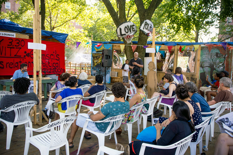
For Walking the Edge organizers, walking signals a fundamental freedom: access to the processes of urbanization. Their strategies for constructing social space recall the “right to the city” ethos of French philosopher Henri Lefebvre, for whom the citizen must be the “protagonist of the city that he himself had built.” Lefebvre’s urbanism — and that of his contemporaries such as Michel de Certeau — are a touchstone for many of the socially engaged artistic practices that have emerged in the last two decades. These participatory models view artist and audience as collaborators, engaged in aesthetic and democratic processes. Tuned to their social context, and often durational, socially engaged practices draw on a range of disciplines, from community organizing, pedagogy, urban planning, and cooking, to walking tours and neo-Situationist excursions. New Yorkers may recall Suzanne Lacey’s conversations on Brooklyn stoops; Paul Ramírez Jonas’s ceremonial “Key to the City;” or Thomas Hirschhorn’s sprawling, temporary monument to leftist thinker Antonio Gramsci, built with residents of a Bronx housing project.
As a strategy for public artwork, participatory engagement reflects a shift from monumental memorials or ornamental sculpture — “plop art,” for example — to processes designed to catalyze social change. “Walking informs a body and a body has a voice,” Nowacek told me, reflecting on the democratic potential of Walking the Edge. “We can’t know what we want the city to be until we give ourselves the gift of experiencing the city through this kind of lens.”
For the artists, DCP provides access to a large cross-section of the city through a set of practices for planning engagement that complement their own. The waterfront planning process has included public conversations and workshops with community groups, the Governors Island Waterfront Planning Camp, and other virtual waterfront-related activities in May. “The Waterfront and Open Space planning group is asking: How do we create waterfront spaces for people to be in? What do those spaces look like?” according to WoW co-curator and Culture Push co-founder Clarinda Mac Low. “They’re deeply engaged with communities on a day-to-day basis.”
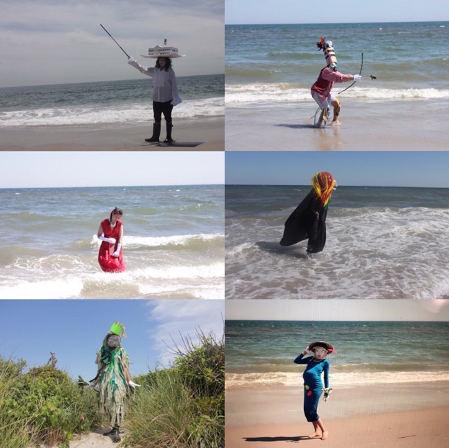
As a public artwork, Walking the Edge quietly resists Bloombergian urbanism, whose image-making sold the city as a luxury good. Instead, Mac Low told me, Walking the Edge asks “how humans are connected to that edge, outside of capital.” The project’s commissioned artists suggest other modes of relation to the water, through sacred ritual, philosophical rumination, and performances that reckon with the spatial histories of colonization and enslavement. The artist-made videos and images appearing on Instagram throughout the summer reflect the conventions and constraints of social media and socially distanced methods of production. They include shots of breaking waves, blue sky, shorelines cluttered with trash. Many of the images are overlaid with text or marked by the insertions of figures, costumes, or props. These processes constitute interventions not just into the landscape, but into the very idea of landscape as a visual prospect bounded by the viewer’s one-point perspective.
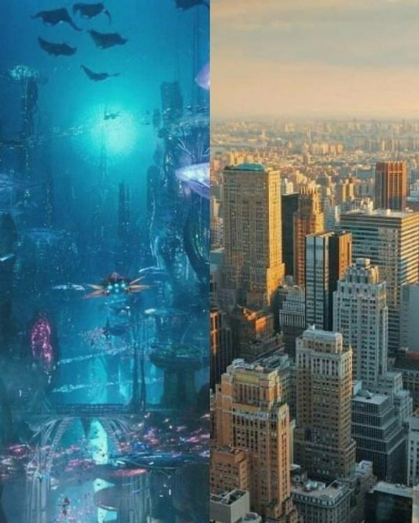
Sto Len, for example, references former bodies of water and Indigenous place names on his path through Queens, conjuring what is no longer visible. At Shirley Chisholm State Park and other sites, Jodie Lyn-Kee Chow revives the Afro-Caribbean folk art form Junkanoo, which satirizes white enslavers. And Simone Johnson, whose formative experience on Staten Island informs her contribution to the project, meditates on the mythical city of Atlantis as an Afrofuturist model for climate planning.
These artists suggest that the waterfront, marked by elaborations of power, imaginative or ideological invention, and violent erasures, is not a destination but a site continuously under construction. Together, they articulate an edge aesthetics distinct from waterfront-as-visual-amenity. They suggest that the value of seeing, within public space, lies in mutual recognition: of racial and economic difference; of individual and collective claims to freedom; of the common good. Toward this end, Walking the Edge offers varied techniques, perspectives, and modes of access. For example, the project’s social media presence is designed to be textually interactive; alt text descriptions are accessible to blind or visually impaired people. Daily posts encourage embodied and critical reflection: How do you identify yourself in this place? What have you received from these shores? What have you given? What does waterfront access look like to you? How do you define resilience?
Scrolling through Instagram, I wonder what an edge aesthetics might do. Is it capable of instigating social change — or even influencing a city budget? Can we cultivate discourse that challenges dominant racial, economic, gendered, or ableist structures of power by working alongside regulatory instruments? In June, when I asked members of DCP’s Waterfront and Open Space division how they plan for unregulated movement, the line went silent for a moment.
Modern city management involves a bulkhead of infrastructures and protocols, from zoning and permitting to more violent coercion. Think of Staten Island’s Bay Street Corridor, newly rezoned, where a police officer choked Eric Garner to death just steps from the water. Picture any place where cops in tactical gear showed up this summer to kettle, gas, or fire on people streaming down avenues and over bridges, shouting “Whose streets? Our streets!” This insurgent movement — adjacent or co-extensive with Walking the Edge — suggests that an island imaginary is possible: one whose bounded terrain and littoral entanglements may yield unforeseen, even outlandish adaptation. “Walking the Edge opens up the space for many possibilities,” Simone Johnson noted, reflecting on how community engagement might inform city planning, “but if you want community voices to be involved, then you have to listen to those voices.”
The views expressed here are those of the authors only and do not reflect the position of The Architectural League of New York.