
We are celebrating 15 years — and counting — of stories that are deeply researched and deeply felt, that build a historical record of what the city has been.
We are celebrating 15 years — and counting — of stories that are deeply researched and deeply felt, that build a historical record of what the city has been.
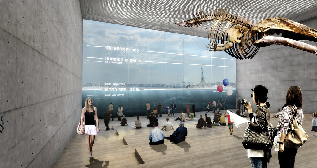
Last week, ten interdisciplinary teams charged with developing solutions to protect the New York metro region from future climate events presented their final plans to crowds totaling more than 1,000 people at events in New York and New Jersey. The proposals are the result of Rebuild by Design, a seven month-long, three-phase competition launched by the US Department of Housing and Urban Development (HUD) and its Hurricane Sandy Task Force. Thursday evening’s New York City event took place on the 29th floor of 250 Vesey Street, overlooking the Hudson River, New York Bay, and many neighborhoods hit hard by the 2012 superstorm.
For this latest phase of the competition, each team focused on a single concept, presenting its basic details at the event on one large board per team and, in some cases, models of their designs. (Additional information and videos produced by the teams are available on the Rebuild by Design website.) Over the weekend, the teams presented their proposals in greater depth to the Rebuild by Design jury, who will now select an undetermined number of winners for implementation, funded in part by public money drawn from $4 billion in HUD Community Development Block Grants. While certain elements of the proposals may seem fantastic — artificial barrier islands along the Atlantic shore among them — the competition explicitly called for implementable and fundable solutions. Even so, there are still a number of questions to be answered. Given that the proposals span multiple local and state jurisdictions, at costs (for full implementation) that sometimes exceed the federal money available, how will these projects be carried out and what supplementary funding strategies will be pursued? And with most teams concentrating on specific locations, will the selection process involve an effort to spread limited funding across the region?
Many of the designs, which address distinct parts of the region running from the Jersey shore on to Bridgeport, Connecticut, feature a common commitment to economic as well as ecologic vitality, and utilize common strategies: berms — raised banks of land that form softer, greener barriers to sea level rise than pure sea walls — are particularly common in the proposals, as are plans for ecological restoration to manage storm water runoff and blunt the force of storm surges.
The Big U | BIG Team | New York City
BIG wraps Manhattan from West 57th Street down to the Battery and up to East 42nd Street in three distinct storm protection systems, creating “compartments” that would operate independently even if barriers in another compartment failed in a storm. Park berms shield the Lower East Side, deployable barriers under the FDR protect Two Bridges (one of the few cases “hard” infrastructure was proposed in the competition), and elevated walkways and berms embedded with cultural facilities do the same for the Battery and the west side. (For more on a Parsons M.Arch studio run by the BIG team and how students’ work influenced their proposals, see the recent UO Studio Report “Cities with Wet Feet” by BIG architect Daniel Kidd.)

The Commercial Corridor Resiliency Project | HR&A Advisors, Inc. with Cooper, Robertson & Partners | Red Hook, Brooklyn; Far Rockaway, Queens; Asbury Park, New Jersey
HR&A and Cooper, Robertson & Partners approached the competition in what could be called Bloombergian fashion. Rather than step back from the waterfront, they first consider how to expand or improve commercial districts along the waterfront, then implement stormwater management and sea barrier integration to protect them. Red Hook gets a “Maker’s District” — a manufacturing hub — that’s outfitted with flood-proofed buildings; Far Rockaway, a beefed-up transit hub at Beach 116th Street that creates new transit-oriented retail opportunities; and Asbury Park, a boardwalk built on top of a berm that protects adjacent storefronts from damage.
Living with the Bay | Interboro Team | Long Island
Interboro — with the rather expansive site of Long Island — put forward a multipronged proposal that operates at a variety of scales (regional to specific sites) and in five distinct ecological conditions (oceanfront, barrier island, marsh, river and stream estuaries, and uplands). Their proposed interventions are equally as varied: transit-oriented development along the LIRR corridor is coupled with bioswales to retain stormwater, marsh islands are rebuilt, barrier islands bermed, and new housing opportunities in the uplands identified.
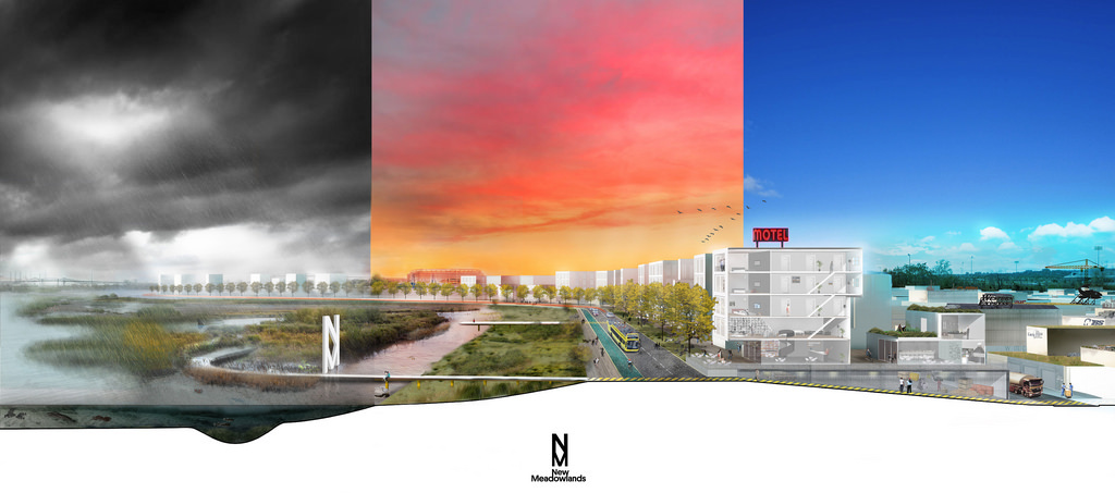
New Meadowlands: Productive City + Regional Park | MIT CAU + ZUS + URBANISTEN | The Meadowlands, New Jersey
MIT CAU + ZUS + URBANISTEN break up the Meadowlands to rebuild them; the Meadowlands become the twin public spaces of the Meadowpark and the Meadowband. The Meadowpark is a nature preserve that expands ongoing marshland restoration work, adding berms and public access to protect existing development and provide park amenities. The Meadowband runs between the park and the existing city, protecting the latter with a street, a Bus Rapid Transit line, and public space. And existing development is not left to rising seas. On the contrary, the team advocates for the upzoning of areas along the Meadowband to encourage denser, more urban development, which could produce an increase in tax dollars for local municipalities.
Resist, Delay, Store, Discharge | OMA | Hoboken, New Jersey
OMA’s approach for the Hoboken, Jersey City, and Weehawken coast is all about water management. While they include hard and soft infrastructure to protect against flooding, systems to soak up flash flooding and store it so as not to overwhelm the drainage system — and pumps and drainage routes to get the water out as quickly as possible — are at the heart of their pitch.

Hunts Point Lifelines | PennDesign/OLIN | Hunts Point, Bronx
PennDesign/OLIN seeks to protect one of New York’s most crucial pieces of infrastructure: the produce, meat, and fish markets in Hunts Point that serve roughly 30 million people in the broader region. To do so, the team constructs berms and flood walls around the markets, and, in order to use the hub as an active distribution center during disaster, develops waterway transit connections between it and the rest of New York City. It also considers the typically underserved local community — which feels the burden of such crucial infrastructure in the high volume of truck traffic and its serious public health effects — by integrating existing proposals to mitigate traffic.
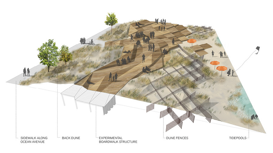
Resilience + The Beach | Sasaki/Rutgers/Arup | Jersey Shore, New Jersey
The Sasaki/Rutgers/Arup team focuses on three regional types on the Jersey Shore — barrier islands, headlands, and inland bays — and sites its recommendations in three case study communities. In Berkeley Town Center (inland, but with good access to a nearby barrier island) the aim is to develop eco-tourism facilities on what is now “underutilized” land. On the headland of Asbury Park (also studied by the HR&A team), a redesigned boardwalk and dune infrastructure protect the coast while green streets running inland aid in drainage. And surrounding the inland bay of Natco Lake, dredging operations create new wetlands, and dredge materials are used to create super levees on the coast.
Living Breakwaters | SCAPE Landscape Architecture | Staten Island
SCAPE brings their distinctive focus on promoting ecological health through new infrastructure in proposing a network of breakwaters along the Staten Island coast. In addition to buffering against wave damage, flooding, and erosion, the complexity of the breakwaters creates new habitats for sea life. Rather than blocking communities off from the sea, a series of hubs sited behind the breakwaters provide recreational programming and educational facilities, including wet laboratory space and classrooms, to encourage engagement with the aquatic ecosystems nearby.
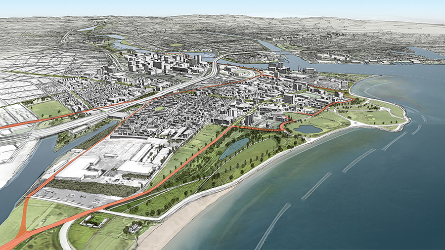
Resilient Bridgeport | WB unabridged with Yale ARCADIS | Bridgeport, Connecticut
WB unabridged and Yale ARCADIS also establish offshore breakwaters, and couple them with the elevation of a waterfront street and berm construction to protect the South End of Bridgeport. Their call for the construction of a specific building, a resilience education and community center, sets them apart from those teams that focussed primarily on landscape interventions. The center would provide various social services and recreation opportunities and, in severe weather, serve as a self-sufficient shelter.
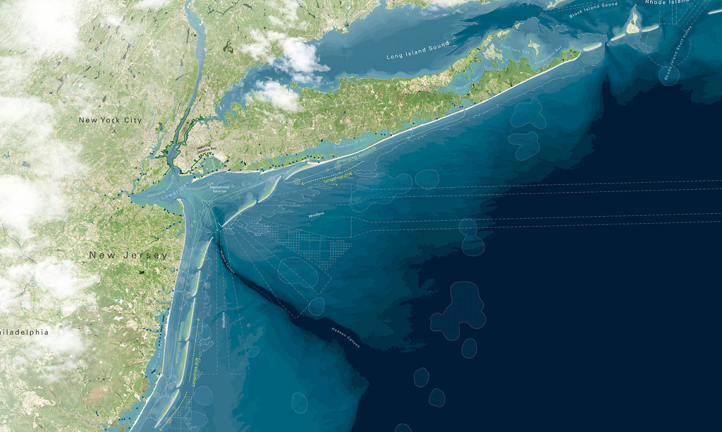
Blue Dunes | WXY/West 8 | Offshore New York & New Jersey
WXY/West 8 laid out what is assuredly the most regional vision of the group: off shore dunes running from the southern edge of the Jersey coast to the end of Long Island that dull the force of storm surges. While inserted into the natural landscape, the dunes are meant to meld with local hydrology and ecology. The dunes could also house wind turbines to create a new source of renewable energy for inland communities. The team calls for the creation of the Blue Dunes Research Initiative to investigate the questions of water quality, habitats, recreation, navigation, constructability, and funding that their proposal brings to the fore, which could produce valuable research with implications far beyond the New York metropolitan region.
The views expressed here are those of the authors only and do not reflect the position of The Architectural League of New York.