We are celebrating 15 years — and counting — of stories that are deeply researched and deeply felt, that build a historical record of what the city has been.
We are celebrating 15 years — and counting — of stories that are deeply researched and deeply felt, that build a historical record of what the city has been.
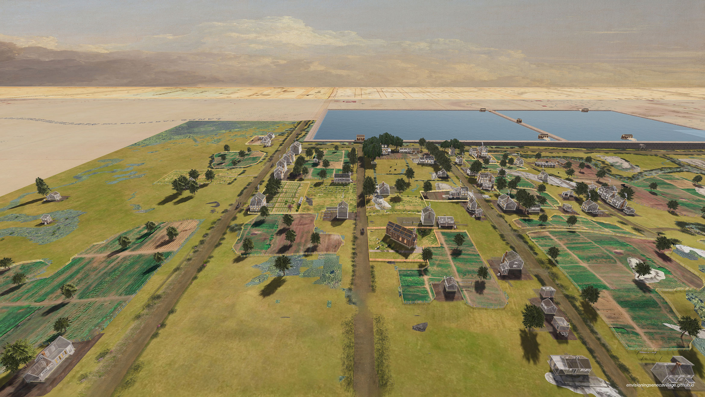
The highest point in Central Park, Summit Rock once looked out over a thriving rural community. Established in 1825 by free Black New Yorkers seeking respite from the discrimination and bustle downtown, Seneca Village flourished. Then, in 1857 its more than 220 residents — and their homes, farms, churches, and businesses — were cleared away to establish the city’s vast new park. Only Summit Rock was left behind, and the story of Seneca Village, too, was all but written out of history. Since the 1990s, scholars, educators, archeologists, artists, and village descendants have helped restore Seneca Village back into public memory. This year — the 200th anniversary of its founding — the Central Park Conservancy has kicked off a multiyear program to inform a permanent commemoration at the site. And you can now “walk” to the top of Summit Rock (known to residents as Nanny Goat Hill) and through streets in a complex 3D model of how Seneca Village might have looked in the spring of 1855.
Gergely Baics, Meredith Linn, Leah Meisterlin, and Myles Zhang, whose fields of expertise span archeology, GIS, cartography, architecture, and urban history, developed Envisioning Seneca Village to correct, and create, a public record. No known images of Seneca Village exist. Meanwhile, on the internet, where most people get their information, one can find historical images of run-down “shanties,” falsely identified as belonging to Seneca Village. They perpetuate the idea that the community had no value, originally marshaled to justify its destruction. For their evidence-based reconstruction, the team extrapolated from diverse sources: census records, land survey maps, archeological digs, and more. Where the historical record fell short, they engaged in “informed speculation,” a unique methodology of carefully developed and rigorously documented inferences that fill in the texture of everyday life, from fences to clotheslines. Below, the authors walk us through their interactive digital commemoration, and how they drew the lines around evidence and inference. In an era of AI hallucinations and misinformation, they also offer a model of ethical visualization, privileging evidence over myth, and memory over erasure.
In 1825, two years before emancipation was complete in New York State, several African American men and women established a thriving community in upper Manhattan. Located in a rural area just east of Eighth Avenue, between what is now approximately 82nd and 86th Streets, the site was safer and freer than the crowded downtown neighborhoods where many had previously lived. The community grew and by 1855 it comprised multiple generations spread across more than 50 families. Roughly two-thirds were Black (with members hailing from at least eight different US states and one from Haiti), and one-third were of European origins (mostly Irish). Villagers built dozens of houses — some with barns or stables — three churches with cemeteries, and a school. They cultivated small-scale agriculture, livestock, and livelihoods. Some ran their own businesses, and others were savvy real estate investors; many worked for wages in the villages of Yorkville to the east, Bloomingdale to the west, and in the city a few miles to the south. Their houses ranged from one room to three stories, and time and circumstance allowed some families to incrementally improve their homes. For over 30 years, this village flourished.
The City of New York abruptly stopped this growth in 1857 when it used eminent domain to seize all of the property between Fifth and Eighth Avenues, from 59th to 106th Street, to build Central Park. What is now known as Seneca Village (though we do not know if residents themselves used this name) was demolished. Buildings were razed, and the landscape was reshaped. Lives were uprooted as residents sought new footings across the city, the state, and farther afield. The village’s tangible remains were buried, and the community was largely forgotten for more than 150 years.
No known images of Seneca Village survive today and there are no remaining traces of its built environment visible in what is now Central Park. Without such visual evidence, many New Yorkers are unaware of its history. For those who have heard of it and who pursue research online (as so many of us do), accurate information can be difficult to find. An image search for “Seneca Village” returns, among other things, drawings and photographs of shed-like shanties in varying states of disrepair that depict neither the village nor the community that it fostered. These images, often created by well-meaning people who have a genuine interest in the village’s history, can have profoundly negative effects on how the village is understood in our culture that relies so heavily on visual evidence. These misconceptions are not just inaccurate or misleading; they replicate 19th-century media sources that slandered the pre-park inhabitants and landscape in disparaging terms to justify the park’s creation and the village’s destruction.[1]
The persistence of these prejudicial historical narratives should not imply that Seneca Village has remained unexamined, nor that its history remains buried. Since the 1990s, historians, archaeologists, artists, descendants, and other stakeholders have been piecing together what we can know of Seneca Village, its residents, and their life experiences.[2] Their examination of surviving documents and an archaeological excavation in 2011 that unearthed material traces of homes, possessions, and activities has rediscovered much about this small, rural village on the outskirts of the Empire City.[3] A generation’s worth of research bears witness to the villagers and the community they created, but it is an archive that is largely dispersed in scholarly books, articles, and archaeological site reports that are siloed by discipline and not always engaging or decipherable to members of the public.
Seneca Village is one of many 19th century communities across the United States who were dispossessed in the name of development and erased from the landscape. But unlike most of its counterparts, Seneca Village was displaced to build one of the world’s most famous parks, and the detailed surveys, plans, and studies that were the instruments of Seneca Village’s dispossession were preserved as Central Park’s foundational records. There is an uncomfortable irony in working with these sources: they are simultaneously the tools of the village’s demise and erasure and among our most informative sources about the village’s life. Additionally, almost all of these documents were created by village outsiders: specifically, by white men tasked with recording only particular types of information and who harbored their own biases, intentional or unintentional. Such records leave many questions about villagers and their lives unanswered. Archaeological remains provide more insight but carry their own interpretive challenges. The lack of surviving images of Seneca Village also hampers our ability to view (albeit through our 21st-century perspectives) visual evidence of life in that village, its environment, its scale, and its relations.
How to counter misrepresentations that abound online? How to bring together dispersed reliable sources and scholarship and make it all accessible and engaging? How to respond to desires to “see” the village? Openly grappling with all of these challenges, we created a visualized digital repository of the evidence and the scholarship about the village that collects, showcases, and builds upon the work of many others.
Fundamental to Envisioning Seneca Village is an interdisciplinary, collaborative, iterative, and transparent approach. As coauthors, our team brings together expertise in the overlapping fields of history, archaeology, geographic information systems (GIS), and architecture. The central piece of the project is an interactive, 3D model that layers, depicts, and narrates much of what we currently know about Seneca Village’s built and social environment. (It also includes a non-interactive version and a printable PDF with maps.) We make updates and modifications as we learn more: from newly available sources, such as recently digitized archival materials; from new scholarship and the insights of the project’s advisors, the Central Park Conservancy, and other Seneca Village stakeholders; and from research prompted by the model itself.
Where the available evidence ends, the model relies on informed, grounded speculation. This is a methodology that collects, compares, combines, and critically analyzes source materials to synthesize and speculate on life in Seneca Village. We aim to make our methods, sources, and decisions transparent in our methodological summary, an extensive bibliography, and a detailed description of what informs our speculation. Here, we illustrate the layers of our model and our process, including how we have grappled with the irony and biases of sources, absences of information, and challenges of representation.
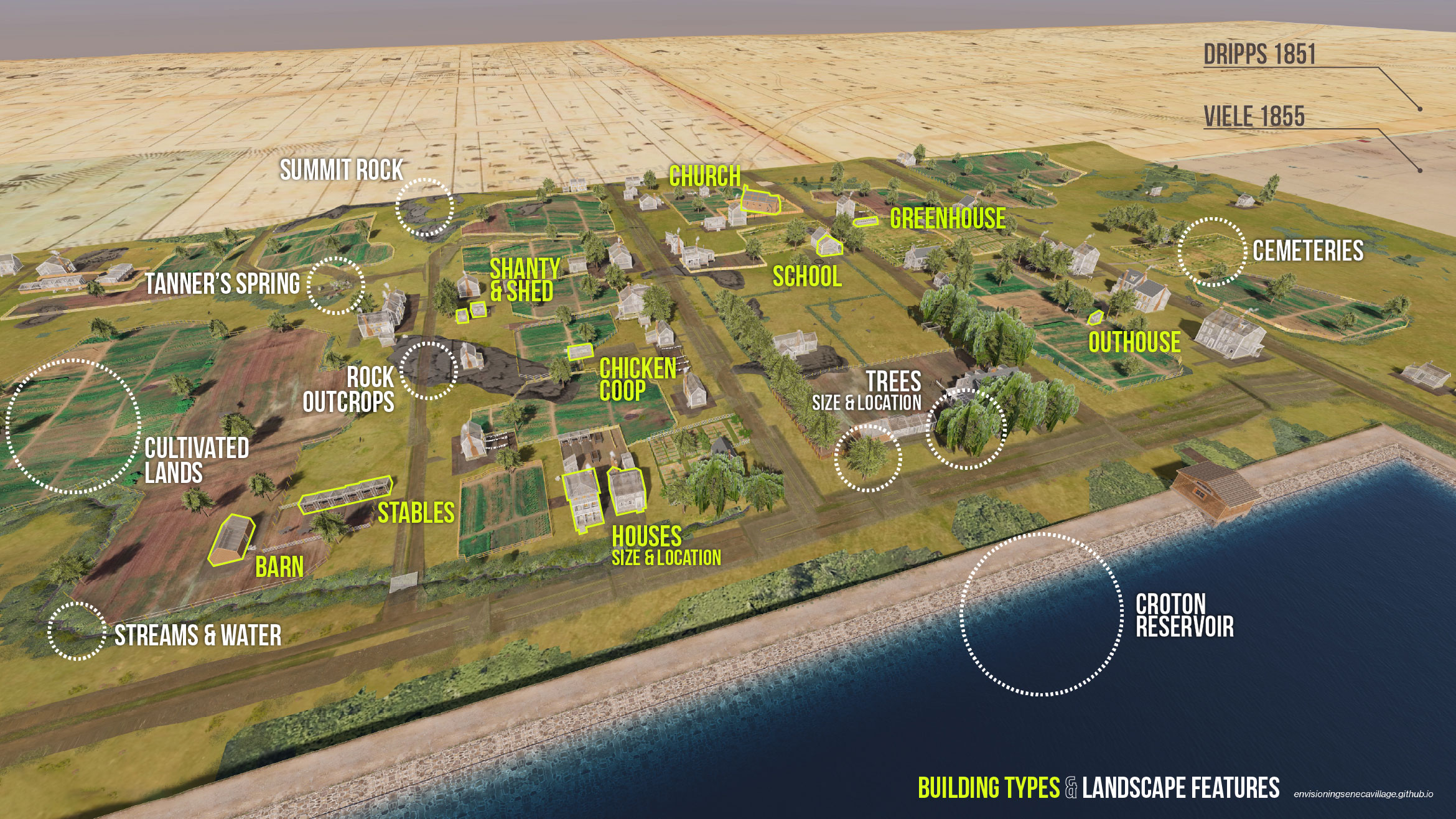
As planning for Central Park was underway in 1855, the entire soon-to-be park site, including Seneca Village, was surveyed by Egbert Viele as a first step toward reshaping the land.[4] The following year, property lines and building footprints were recorded by Gardner Sage as a concomitant first step toward condemnation through eminent domain.[5] Viele and Sage’s maps — both representations from above and from outside — establish the ground plane and the scale of the Envisioning Seneca Village model (and help connect names in census records to specific properties, as we discuss later). With the help of research assistants Sarah Baybeck, Maia Donald, and Jesse Pearce, we geolocated landscape features from the Viele map, ranging from rock outcrops and streams to individual trees. The Viele map also includes a grid of elevation measurements that allowed us to begin modeling the region’s topography in the years preceding Central Park. This landscape is set against the largest infrastructural feature of the mid-19th century city, the Croton Receiving Reservoir, depicted on these maps and documented in its own engineering records. In a literal acknowledgement of these cartographic underpinnings and to depict broader geographical context, we have placed the model of the village atop Viele’s 1855 topographical survey of the pre-park area and laid Viele’s survey atop Matthew Dripps’s 1851 map of all of northern Manhattan.[6]
The landscape described by these maps includes features specific to the Seneca Village community that thrived there. Viele’s 1855 map depicts villagers’ cultivated lands and buildings. Sage’s 1856 Central Park Condemnation Map records property lines and owners as well as building footprints and descriptions — including the number of stories and building types — distinguishing houses from barns and “shanties.” Sage’s map most starkly marks the tension between the existing community and the future park; it was originally used to determine the valuations offered as “just compensation” following the US Constitution’s Fifth Amendment takings clause.
These maps provide a highly detailed accounting of the ground conditions from multiple, mutually confirming sources, but they reflect a framework centered on administrative needs and dominant cultural logics of property and land use. And they were created to support clearing the very land they describe. Despite their original scope, assumptions, and intent, layering these sources together raises a surprising array of new questions.
For example, what was the relationship between the cultivated fields and the many neighbors whose properties intersected and overlapped these lands? Sage’s map records legally recognized properties and divvies the village by lot lines — partitioning the place through a spatial strategy more representative of New York’s denser urban downtown and its party walls. While the property map divides and separates neighbors, Viele’s map depicts expansive planted fields, suggesting more cooperative uses of land in the village that may have augmented the practical value of each resident’s landholding. This led us to ask: How would fencing have functioned and how might the landscape have reflected relationships between these neighbors? In the model, we have reconciled the tension between these two mapped depictions through speculation grounded in historic fencing practices known from other villages that met the tangible, pragmatic considerations of tending to both plants and livestock. Fences here do not separate neighbors or demarcate property but serve to contain certain animals and keep other animals away from crops and church cemeteries.
Despite all that the map sources do include, relying on the “view from above” alone would obscure the interdependencies between neighbors, families, and institutions on the ground. While they lay some baseline groundwork for the model, the cartographic sources simply do not (and cannot) describe the material and social “stuff” of life that populated the village. For that, we looked to other sources.
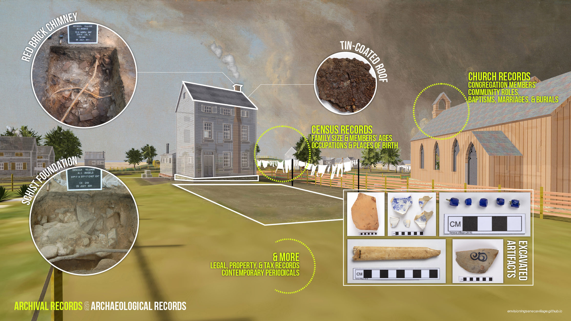
Our envisioning of the William and Charlotte Wilson family house illustrates the importance of bringing together multiple sources. The maps indicate the house’s location next door to All Angels’ Episcopal Church (where Mr. Wilson served as sexton), its material (wood-frame), and size (three stories tall with a foundation measuring approximately 20 feet to a side). But this information, alone, is insufficient for imagining how this structure was a home to a large family that was part of a dynamic community.
So we turned to archaeological and archival records, which speak to the material and social conditions of the village “on the ground” as well as to the ideas and desires of its residents. Archaeological finds, stemming from the 2011 excavation project, provided several insights that we incorporated into the model. Archaeologists discovered the buried ruins of the Wilson House, which confirmed the accuracy of Sage’s survey. In addition, the excavation team determined the building’s foundation, chimney, and roof materials — none of which are mentioned in any of the map or documentary sources. Archaeologists also uncovered other material “stuff” of everyday life that gives us insight into the family’s ideas, tastes, and practices. A couple of examples include the handle of a bone toothbrush and of a washing jug that indicate the importance of hygiene in the Wilsons’ home and their participation in emerging norms of cleanliness, involving regular washing of the hands, face, and body. A slate pencil suggests the importance of education for a family in which all the children who were old enough attended school while their mother also learned to read and write in the village.
We know the Wilson family children attended school because of census manuscripts which list individual family members with their ages, occupations, and places of birth. This informed the model, adding social and material texture and articulation to the architecture. For instance, we know that washing clothes by hand was among the most labor-intensive of the myriad tasks necessary to maintain a rural household, and as we still know today, large families with many children produce a lot of laundry. Throughout the model, the relative size of laundry lines roughly indicates the size of the families that lived in the nearby houses. Navigating the model, one finds smaller details indicating regional differences in residents’ places of birth — a nod to the migration stories that led here — while also lending architectural differentiation that reflects the diversity of the village. The most conspicuous example is our depiction of a Caribbean-style upper-story porch on the house of Charles Sylvan that gestures toward his origin in Haiti.
As we continued to layer archival sources — such as church records and wills — we could envision more clearly how the residents of Seneca Village may have lived and interacted. But each layering raises new questions. There are elements of the model with firm evidence (such as excavated building foundations) as well as elements that require imagination drawn from that evidence, from comparative sites, and from informed conjecture (such as the articulation of windows, their shutters, and the laundry).
Across the project, we employ varying levels of opacity to convey to the visitor varying levels of certainty. We are able to render elements underpinned with specific, reliable evidence from archival and/or archaeological sources with more confidence and, accordingly, with more opacity. Alternatively, those that are based on comparative sources (or other reasonable assumptions) we represent with more transparency. For example, the roof, chimney, and foundation of the Wilson house are more opaque than most of the other homes in the village because the archaeological excavation uncovered parts of them — we know the roof was tin-coated iron; the chimney was red brick; and the foundation was locally occurring schist stone. In the project website’s section on “Speculations and Assumptions,” we explain our decisions about representing landscape features, buildings, and the human traces that result from living in community without overstepping our speculations into hypothesizing people and their bodies. This is not a line between truth and fiction, but a method itself: balancing a collection of fragmentary material and archival evidence and our desire, our ability, to imagine a Seneca Village as a whole and complex community.
In the model, we bring these disparate sources and speculations together in small architectural details, a smattering of ephemeral “extras,” and textual annotations which appear as numbered popups as visitors navigate the interactive model.
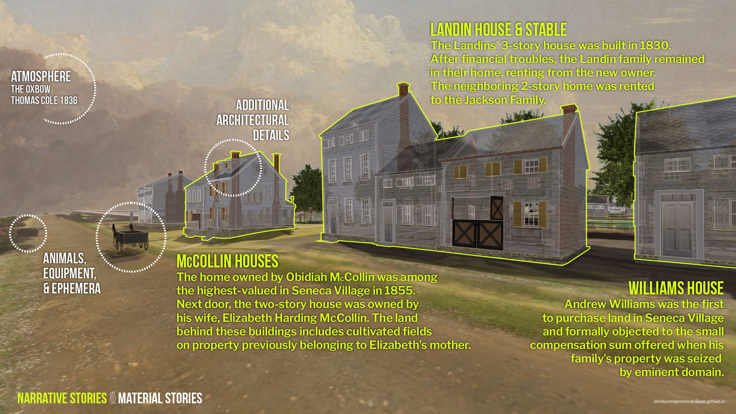
Along 86th Street, for example, the annotations tell the stories of several thriving landowners as well as of neighbors relying on one another in times of hardship. We tell the story of the Landins, who, after hitting financial troubles, remained in their home by renting from the new owner; and of Andrew Williams, who was among the first to purchase land in what would become the village and among those who protested the city’s low valuation of their homes during the condemnation process. Affidavits submitted by villagers as their property was being seized often described the improvements and investments they made to their buildings and land over the years. Wherever possible, the model reflects their testimony (for instance, the water well shown in front of the Mathews house on 84th Street).
We narrate the story of the McCollins home on 86th Street. Despite its relatively modest size, census records cite a higher valuation than most other homes in the village. We gesture toward this higher value through additional architectural elements, like dormer windows and more elaborate window trim. Elsewhere in the model, we indicate differences in home value and age with variations in building materials, weathering effects, and different combinations of doors, shutters, and wood siding. On valuation — both absolute and relative — our sources once again come into conflict with one another. The city devalued properties during condemnation, so our project uses other records, such as affidavits and censuses, and informed speculation to reclaim and visually convey what they might have been worth to their owners.
Throughout the model, we have added ephemera — animals, equipment, and other small things — where we imagine they would have been present. Children’s toys, slate writing boards, and 19th-century games of hopscotch are in the school yard. The placement of certain animals and tools is often based on adult residents’ lines of work, such as carts used to carry goods in the backyard of cartman Andrew Williams. We also show the silhouettes of goats, chickens, pigs, cows, and horses in places where these animals would have most likely been found, such as on the highest elevation point in the village, then evocatively called Nanny Goat Hill. Through the careful layering and placement of small details from diverse and fragmented sources, along with informed speculation, the model enables users to reimagine, remember, and reflect upon a once-whole community filled with people and their stories. Of course, this reimagining is a continual process, and the project is ongoing. We continue to refine and develop the image of Seneca Village as more is learned, and we are planning for more stories to tell.
Lastly, our choices in representing the village’s atmosphere impact the overall experience of navigating through the model. Thomas Cole’s 1836 painting The Oxbow serves as the model’s backdrop and renders its sky. While it depicts the Connecticut River in Northampton, Massachusetts, it is an example from the Hudson River School and thus indicative of one 19th-century way of thinking about the landscapes north of the city and imagining or envisioning non-urban life within those landscapes. The painting, of course, provides merely one suggestion of what the atmosphere of Seneca Village might have felt like in the spring of 1855. As such, we hope it is a persistent reminder that the model is always two things at once: both a collection of things we know and a collection of things we might imagine.
“The Present Look of Our Great Central Park,” New-York Daily Times, July 9, 1856, 3.
Roy Rosenzweig and Elizabeth Blackmar, The Park and the People in 1992 (Cornell University Press, 1998).
Before Central Park: The Life and Death of Seneca Village, exhibition curated by Cynthia R. Copeland and Grady Turner, New-York Historical Society, 1997, https://web.archive.org/web/20210813045149/https://www.nyhistory.org/seneca/.
Map of Lands Included in the Central Park from a Topographical Survey, Egbert L. Viele, New York, 1855, New York City Municipal Archives, Parks and Parkways Drawings and Plans Collection.
Central Park Condemnation Map, Gardner A. Sage, 1856, Municipal Archives.
Map of that Portion of the City and County of New-York North of 50th St. Surveyed & Drawn by R.A. Jones, C.E., Matthew Dripps, 1851, David Rumsey Map Collection.
The views expressed here are those of the authors only and do not reflect the position of The Architectural League of New York.