
We are celebrating 15 years — and counting — of stories that are deeply researched and deeply felt, that build a historical record of what the city has been.
We are celebrating 15 years — and counting — of stories that are deeply researched and deeply felt, that build a historical record of what the city has been.
Certain parts of New York City can be seen as laboratories of subsidized housing strategies. Public housing developments, urban renewal projects, tax incentives for affordable housing, state subsidy for single-family homes; the list goes on. And this range of policy responses is, of course, especially apparent in neighborhoods where poverty has historically been concentrated. Coney Island is one such neighborhood, with a building stock that overtly reveals the diversity of public investments over the past century, even though we sometimes forget that it is, primarily, a residential neighborhood.
Coney Island is a national icon because of its amusement parks and boardwalk. And recent city planning efforts focused citywide attention on the future of its amusements rather than its residents. But Coney Island — particularly its western portion — is a community where people live, and those residents currently face multiple destabilizing pressures: the expiration of affordability programs, the impact of flood insurance reform, and the challenges of readiness for the next big storm. In this week’s feature, housing advocate Oksana Mironova, who grew up in the area, looks at this contemporary crossroads through the lens of the neighborhood’s development and planning history. The area has been the subject of no shortage of plans. But none of these has yet accounted comprehensively for the historical, demographic, architectural, and economic forces that have shaped it. —C.S.
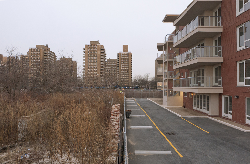
Housing developments at West 32nd Street and the Boardwalk | Photo by Cole Evelev
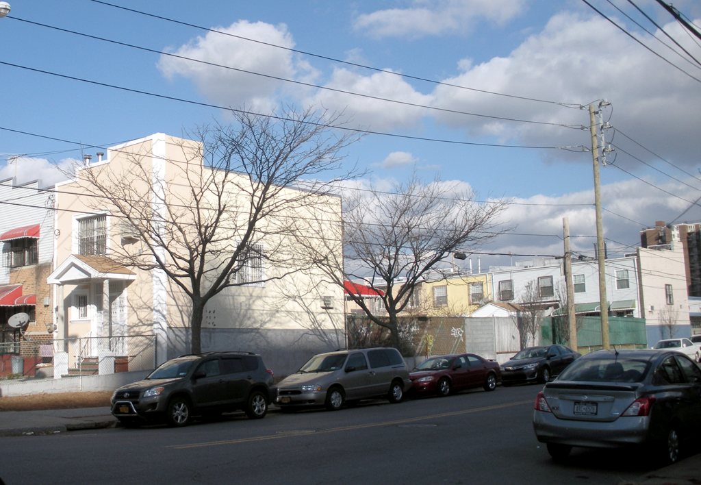
From the intersection of West 29th Street and Surf Avenue in Coney Island, you can see half a century of urban planning. On the northeast corner, rising behind a green chicken coop, is Sea Park East, a sand-colored state-subsidized development with a dramatic setback. Across Surf Avenue is the Shorefront Center, a modern rehabilitation and nursing care facility constructed on the site of what was the Half Moon Hotel, built in 1927 to turn Coney Island into a year-round destination. Further west on Surf Avenue are the five 14-story red-brick buildings that make up the Coney Island Houses, one of the oldest public housing developments in the neighborhood. The effect of Superstorm Sandy on the development is still apparent: a semi-permanent plywood structure on the sidewalk encloses its external boiler, brought in after the storm to temporarily provide heat for the complex. Beyond the Coney Island Houses stands a recent addition: a five-story market-rate development surrounded by a large, empty lot. Each unit has a large balcony overlooking the boardwalk, but none appear occupied. On the other side of West 29th Street is the newly built Coney Island Commons, a brand new yellow and red affordable complex and YMCA.
West 29th Street is located in the heart of the neighborhood’s western portion, a low- to moderate-income residential area bounded by West 37th Street to the west and Stillwell Avenue to the east and home to approximately 27,000 people. While the eastern portion of Coney Island is home to the internationally known amusement district, the western portion is frequently overlooked.
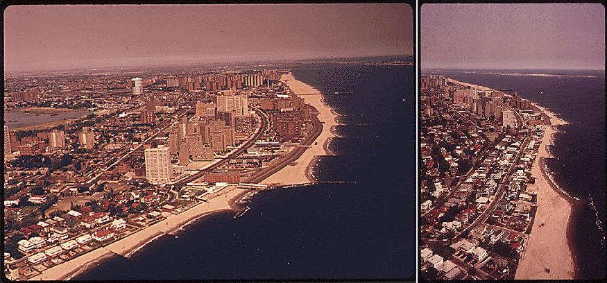
Coastal development in Coney Island, 1974, as documented by the EPA’s Documerica project | Images via National Archives
As a teenager growing up in the neighborhood, I was conscious of the architectural forms that dominated the landscape. While studying urban planning and working in affordable housing, I have become more aware of the planning policies that have shaped the neighborhood. According to 2010 U.S. Census data, there are 10,200 units of housing in Coney Island West. With 4,091 public housing units, 3,629 HUD-subsidized and Mitchell-Lama units, and over 1,000 Astella Development Corporation-built units, the majority of homes in the neighborhood were financed with federal, state, or city subsidy. Even though Coney Island is a product of many plans, it is not a planned neighborhood. And, despite a mid-century goal for comprehensive neighborhood planning — including the development of daycare centers and health service providers, in conjunction with housing — “there were no funds available for any new community infrastructure” beyond one new school and an underused mid-block pedestrian greenway that was not fully completed, according to a 1979 planning study.
In 2009, Coney Island underwent a rezoning, which aimed to foster development in the neighborhood. However, the recession and Superstorm Sandy have both slowed construction and exposed the neighborhood’s vulnerability. Today, Coney Island West can benefit from both investment in new housing and preservation of its existing options. But to better understand these contemporary neighborhood needs, we must first investigate Coney Island’s planning and development history.
Robert Moses and Mayor Lindsay Reimagine Coney Island
The 1939 WPA Guide to New York City describes residential Coney Island as “a drab community…where some one hundred thousand persons live the entire year.” Coney Island shared characteristics with other outer-borough working-class neighborhoods, which became identified as slums both in political and popular discourse. Within a few years, Robert Moses — New York City’s 20th century master builder — set out to reshape these neighborhoods, utilizing federal funding for slum clearance and public housing construction available under Titles I and III of the 1949 Housing Act. Moses’ strong distaste for the disorderly amusement district motivated his push for a residential rezoning of Coney Island, which according to an April 1953 article in The New York Times “enabled Coney Island to fit into to the pattern envisioned for it as a largely residential seaside area.”
Photo by Cole Evelev
Moses oversaw the construction of two New York City Housing Authority (NYCHA) developments in Coney Island — Gravesend Houses and Coney Island Houses — in the mid-1950s. In 1961, the City Planning Commission approved a larger redevelopment plan for Coney Island West. As Coney Island historian Charles Denson puts it in Coney Island Lost and Found, Moses’ “battle plan was to attack Coney Island from its western flank and work his way east.” Two more developments went up in the mid-1960s: Haber Houses, a NYCHA senior housing complex, and Sam Burt, a limited-equity co-op sponsored by the Fur, Leather, and Machine Workers Union. Sam Burt was advertised as “a democratic, integrated housing community designed for vacation living the year ‘round.”
Development in Coney Island up to this point had been relatively incremental. With the introduction of the Vest Pocket Community Development Plan for Coney Island West in 1967, wholesale “slum” clearance, envisioned by Robert Moses and implemented by Mayor Lindsay’s administration, began. The plan called for the construction of a mixture of low- and moderate-income housing, and further acquisition of land. The time lag between proposal and implementation of the plan encouraged deterioration of the existing housing stock, according to Denson, as some property owners deferred maintenance of their rental properties while waiting for the city to buy them out.

A Coney Island cottage photographed by an inspector of the City’s Tenement House Department | Photo via NYPL
Contested Battleground: Neighborhood Resistance to Urban Renewal
Redevelopment of the neighborhood continued in the context of the civil rights movement, “white flight,” and neighborhood-based resistance to urban renewal of the late 1960s. Coney Island West became a contested battleground. At the time, the neighborhood was working-class, and racially and ethnically mixed. According to Ronald Stewart, a life-long resident of the neighborhood, predominantly Italian families often lived in owner-occupied housing between Stillwell Avenue and West 16th Street. Further west, black, Hispanic, Irish, and Jewish households tended to live in tenements, rooming houses, and bungalows.
Many black and Hispanic residents displaced by other urban renewal projects were steered to Coney Island by the City, as well as to other outer-borough locations. Excluded from most stable housing options by Federal Housing Administration’s mortgage restrictions, white-only covenants, and racist practices by individual landlords, these families were left with limited housing options. Those that were available — such as summer bungalows hastily converted for year-round use and apartment buildings subdivided into rooming houses — often offered little stability or comfort.
Though the City Planning Commission claimed that the 1967 Community Development Plan would be rooted in community participation[1], decisions about the plan’s major aspects, including slum clearance, site selection, and building form, were made without meaningful community input. Community organizations that advocated on behalf of the different ethnic, racial, and socio-economic groups in the neighborhood vied for representation within the rigid redevelopment framework set forward by the City. The aging Jewish population fought for senior units. Black and Hispanic families fought exclusion from NYCHA properties based on household composition and rent payment history. In addition to rallies and meetings, organizers staged more militant actions, like office takeovers and hunger strikes.
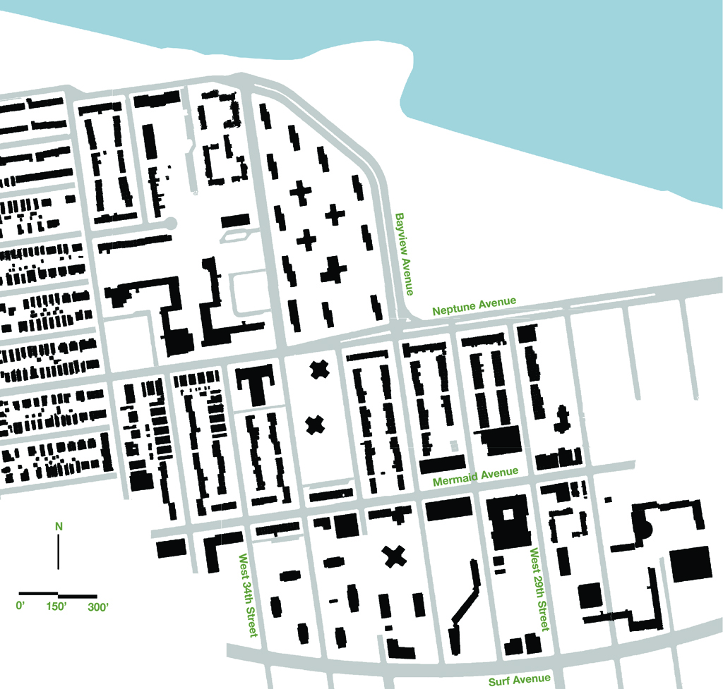
Figure ground diagram of a portion of Coney Island West, showing the diversity of building typologies in the neighborhood | Diagram by Andrew Wade
City, State, and Federal Investment
As NYCHA developed six complexes in Coney Island between 1967 and 1974, state and federal agencies also played a role in the neighborhood’s growth. A number of privately built high-rises — financed with federal developer subsidies through the Section 236 program of the 1968 Housing and Urban Development Act — went up. Seven complexes aimed at a moderate-income population were constructed with Mitchell-Lama financing, many of which were built by New York State’s Urban Development Corporation (UDC). Like NYCHA and HUD-subsidized properties, UDC’s developments drew on modernist architectural traditions, featuring elements like low-site coverage and shared public courtyards. But unlike NYCHA, which primarily sought to maximize the number of units constructed, UDC also actively promoted architectural innovation and sought to apply innovative housing strategies, and its developments were significantly more conscious of how they fit into the existing neighborhood context.
By 1974, Coney Island had become deeply segregated, by race and income, in line with a country-wide trend of intensified spatial segregation[2]. Leveraging growing discontent with urban renewal and concern over white flight, the Neighborhood Improvement Organization (NIO) — representing the mostly Italian-American residents east of 16th Street — worked with the Pratt Center on a preservation plan for the area, which was then adopted by the city. By the mid-1970s, wholesale slum clearance was no longer a threat.
An Astella-built home | Photo by Oksana Mironova
The NIO formalized into the Astella Development Corporation in 1975, in the midst of the city’s fiscal crisis that left many city-owned lots and properties west of 16th Street — acquired by the city for urban renewal and through foreclosure — empty and unused. Astella, according to its current executive director Judi Orlando, developed around 1,000 single-family, owner-occupied homes on this land in the 1980s. These attached two-story brick and white vinyl-sided properties aimed to attract “transit workers, sanitation men, police officers, teachers, tradesmen” many of whom came from outside the neighborhood. Astella was one of many community-based organizations that the Koch administration relied on to spearhead development — primarily lower density subsidized housing that didn’t require ongoing operation funding — in disinvested neighborhoods after the fiscal crisis of the 1970s.[3]
Coney Island West Today: Demographic Change, 2009 Rezoning, and Superstorm Sandy
Coney Island West has experienced significant demographic shifts within the last few decades. Italian and older Jewish residents moved or passed away, while Russian-speaking Jewish immigrants began to arrive in the 1990s, following the establishment of the more well-known enclave in Brighton Beach. Since 2000, the Hispanic and Asian populations have grown markedly, while the black population has decreased. According to the 2010 U.S. Census, the neighborhood’s seven census tracts are 39% black, 29% Hispanic, 23% white, and 10% Asian. The poorest census tract out of the seven, with a median income of $9,000, stretches along the boardwalk and encompasses a senior NYCHA development, an adult care facility, and a couple of blocks of tenements that survived urban renewal. The highest-income census tract, with a median income of $42,000, encompasses much of the neighborhood preserved by NIO.
In 2009, Coney Island underwent a rezoning that aimed to foster residential, neighborhood service, and retail development on vacant and underutilized land, especially along Surf Avenue, “the entryway to the peninsula.” Cecilia Kushner, Director of Special Initiatives at the Department of City Planning, says the rezoning was meant to strike a balance between the amusement area and neighborhood needs. Judi Orlando and Ronald Stewart both expressed optimism about the rezoning’s potential to attract year-round jobs and residential development — though Stewart wanted the plan to include a firmer commitment from the City that access to those jobs and housing would be given to existing neighborhood residents — and to give Coney Island’s younger generation more reasons to stay in the area. Under a full build-out, the rezoning could create about 4,500 new housing units, with 900 units of affordable housing through the inclusionary zoning program, and would encourage the development of new retail and neighborhood services along Surf and Mermaid Avenues.

Coney Island Commons | Photo by Oksana Mironova
While the recession slowed development, Kushner thinks of the 2009 rezoning as a long-term planning framework for the neighborhood. Some construction is underway in the neighborhood today, including the recently completed Astella-sponsored Coney Island Commons, a 196-unit affordable housing development funded with tax credits that is being developed in conjunction with the YMCA. Despite the damaging effects of Sandy on small businesses along Mermaid Avenue, the street feels lively and well-used by neighborhood residents. Surf Avenue, which has a number of large overgrown lots and almost no street level retail or neighborhood services, feels empty by comparison.
Around the same time the city introduced this most recent rezoning of Coney Island, the neighborhood’s large concentration of Mitchell-Lama and HUD-subsidized buildings found themselves at risk of no longer being affordable to the income groups that had historically occupied them. Some of this risk was the result of predatory equity practices by real estate speculators, and some the result of properties built in the early 1970s becoming eligible to opt-out of their affordability programs in the early 2000s.
Some owners, however, have been able to preserve the affordability of their developments. The tenants association of Sea Park East, according to a tenant leader in the building, worked closely with a new developer, who purchased and refinanced the property with tax credits and HUD subsidies in 2004. Ocean Towers was privatized in 2007 when it was purchased by Cammeby’s International, a group that acquired a number of expiring Mitchell-Lamas around the city at severely inflated costs. According to a 2007 article in the Daily News, tenants experienced immediate rent hikes and declining services. However, in May 2013, after the building suffered significant damage due to Superstorm Sandy, it was sold to Community Development Trust, a private real estate investment trust (REIT). The new owner plans to rehabilitate the property with city subsidies, and has agreed to keep it affordable.
A mobile boiler brought in after Sandy, located in an alley near the intersection of West 31st Street and Mermaid Avenue | Photo by Cole Evelev
The number of subsidized property opt-outs declined after 2008. Many Mitchell-Lamas and HUD-subsidized complexes in the neighborhood remain affordable. However, each property will face the problem of expiring affordability again in 15 to 20 years, when the current round of contracts come to an end. And temporary affordability cannot change permanent location: a significant number of subsidized properties in the neighborhood were damaged by Sandy, and face an uncertain future due to both mounting repair costs and vulnerability to future storms. NYCHA is contending with the same challenges, compounded by its aging infrastructure and a large budget deficit. It took the agency months to restore power, water, and heat in full to its properties in Coney Island after the storm.
Flooding also affected Astella-built homes in the neighborhood. Immediately after the storm, sidewalks along Mermaid Avenue were filled with waterlogged insulation and destroyed furniture. While Astella continues to work closely with homeowners to access Sandy aid, the major long-term storm-related issue for owner-occupied housing in flood-prone neighborhoods like Coney Island is the Biggert-Waters Insurance Reform Act. According to The New York Times, the Act radically reshapes development in flood plains by putting an end to federal flood insurance subsidies. According to Yelena Zolotorevskaya, who studies Sandy’s effects on the neighborhood, the Act will cause insurance rates for some homeowners to skyrocket unless they elevate their homes above sea level at considerable cost. High insurance rates in low and moderate income neighborhoods may increase foreclosure rates, create a downward pressure on home values, and decrease homeowner access to home improvement loans.
Behind the Boardwalk, between West 31st and West 30th Streets | Photo by Cole Evelev
The significant number of challenges Coney Island West faces are rooted in poverty, disinvestment, land-grabs, increasing marginalization, and past planning decisions. While the neighborhood’s needs are not new, Sandy brought their complexity to the fore; NYCHA, Mitchell-Lama, HUD-subsidized, market-rate renters, and single-family home owners all face different levels of vulnerability. The neighborhood is in need of investment, both public and private.
Immediately after Superstorm Sandy, Coney Island saw an influx of volunteers and donations. Responding to a need for community involvement in the direction of the recovery process, Roland Stewart and four other community activists founded The People’s Coalition of Coney Island. The Coalition encourages the general public to see the neighborhood beyond its amusements and advocates for re-investment of a portion of business and amusement profits in the community. Such investment should be channeled not only into new development, but also toward preservation of what already exists. Coney Island’s housing stock, however flawed or battered, is an important asset in an increasingly unaffordable city. Beyond the rides, Coney Island is home to a low- and moderate-income community that continues to face many challenges rooted in urban poverty, paired with new issues associated with climate change. While neighborhood renewal has been a central theme in Coney Island’s planning history, we have to focus just as closely on preserving the existing neighborhood and protecting fifty years of public investment.
NOTES:
[1] 1967 City Planning Commission fact sheet, available at the La Guardia and Wagner Archives repository, Box # 0099E2, Folder #1.
[2] According to a 1974 New York Times article, in an unprecedented ruling on a NAACP lawsuit against the local school district, federal judge Jack Weinstein held city, state, and federal housing authorities at fault for encouraging school segregation through their development and planning practices.
[3] Jonathan Soffer (2012), Ed Koch and the Rebuilding of New York City. Columbia University Press.
The views expressed here are those of the authors only and do not reflect the position of The Architectural League of New York.
Comments