
We are celebrating 15 years — and counting — of stories that are deeply researched and deeply felt, that build a historical record of what the city has been.
We are celebrating 15 years — and counting — of stories that are deeply researched and deeply felt, that build a historical record of what the city has been.
INTRODUCTION
People become urban planners because they want to make life in cities better.
But change comes slowly. And planners often find themselves pigeonholed into repetitive or isolated work as technocrats whose role is to move along processes defined by local laws and regulations, department bureaucracy, or a particular professional culture.
Could planners reshape the process through which they apply their skills? Though architects and artists commonly use their skills to intervene in troubled cityscapes, planners are rarely asked to exercise their creativity in the same way.
My colleague Frank Hebbert and I were mulling over this question at the very same time that a group of concerned citizens in New York City were struggling to make changes in the deadly thoroughfare that dominated their commute: Queens Boulevard. So we asked ourselves: What might a planning intervention look like? Would it be possible to structure the process so that urban planners could offer their unique expertise directly to complex problems in cities?
To help answer these questions, Frank and I launched Planning Corps, a network of volunteer planners whose skills we match with non-profits or community-based projects that frequently confront the kind of planning-type decisions that might benefit from a little technical assistance.
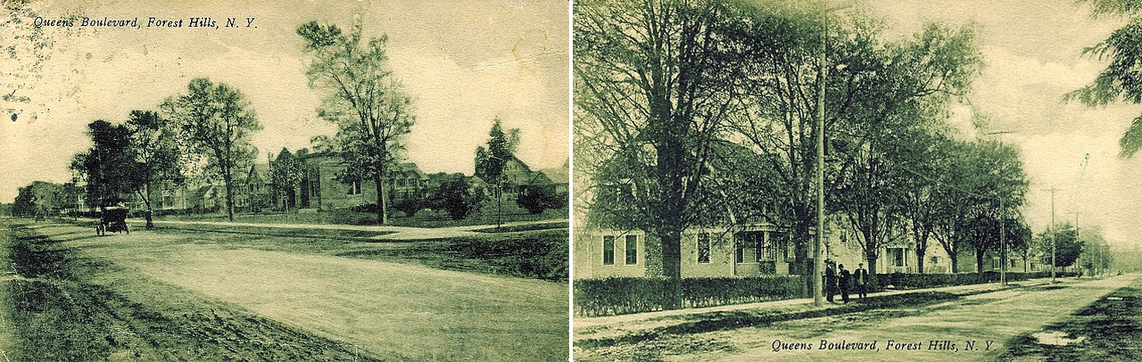
Old Queens Boulevard in Forest Hills circa 1900 | Photo courtesy of OldKewGardens.com
QUEENS BOULEVARD: A BRIEF HISTORY
Queens Boulevard has long been one of the most dangerous corridors for pedestrians and cyclists in New York. But its origins were in the tradition of the grand promenade boulevards that marked great cities of its day. It was conceived as a redesign and connection of two boulevards, Thomas Boulevard and Hoffman Boulevard, to serve traffic coming from Manhattan over the Queensboro Bridge. A 1912 proposal called for a central roadway at 44 feet wide, two side roadways at 28 feet, trolley tracks along the side roads, two 30-foot-wide “malls” or medians separating the roadways, and 20-foot sidewalks on either side. Its combined width of about 230 feet supported multiple uses: a Sunday stroll, a bicycle delivery and a carriage ride. But by 1922, the population of Queens had developed so rapidly that planners widened the roadway to 200 feet to meet the needs of all the new cars on the road.
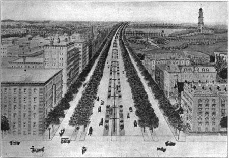
A proposal for the layout of Queens Boulevard by the Queens Chamber of Commerce. Good Roads magazine, June 1914.
In 1933, the Queens Chamber of Commerce created a Queens Boulevard committee to ensure that the development of the boulevard did not occur at the expense of “beautification.” The Chamber even sponsored a competition for ideas on the development of Queens Boulevard in partnership with civic organizations such as the Regional Plan Association, the American Institute of Architects, and the Society for the Beaux Arts. Cord Meyer, the Chamber’s chair at the time, explained:
We plan to study the development of the boulevard, first of all, from the physical angle… We shall try to hasten the completion of the subway, the laying of the water mains, electrical light conduits and gas pipes and the building of the sewers. Then we shall consider zoning.
No one predicted the rampant pace at which the Borough of Queens would grow, nor did they anticipate the traffic that would come with it. By 1963, the entire borough of Queens had experienced more construction than any other borough since World War II, investing over two billion dollars on over 90,000 structures between 1946 and 1962. But development was uneven and difficult to control. Real estate speculation drove up property values at the same time that public service needs were inadequately met. Queens Boulevard was only one of many development projects; in 1963, only half of the roads in the borough were paved. Transportation development lagged behind population growth and housing demand, and local civic leaders repeatedly requested additional funds from the City to keep up with necessary infrastructure construction.
As early as 1971, The New York Times reported on the dangers of Queens Boulevard to pedestrians:
There are times when it seems as though the light is in favor of the pedestrian and he has to look in all directions at once. When the light seems to be in favor in one direction, the cars are turning in another direction. And before he has taken a few steps the “Don’t Walk” signs are flashing.
Most recently, in 2005, the New York City Department of Transportation conducted a traffic safety study on the Boulevard and concluded that traffic volumes were so high that little could be done to improve it. The minor safety improvements that were suggested – the addition of turning lanes and few through-street closures – were either challenged by local stakeholders or lamented for their inadequacy. Opposition from business owners, who feared that changes in the traffic pattern would reduce sales, was the strongest. Mayor Michael Bloomberg shot back that saving lives was a bigger concern than making profit. Still, implementation of comprehensive safety improvements faltered. Signs cautioning pedestrians to be careful while crossing the street stayed up on their posts and became the butt of jokes for transportation advocates.
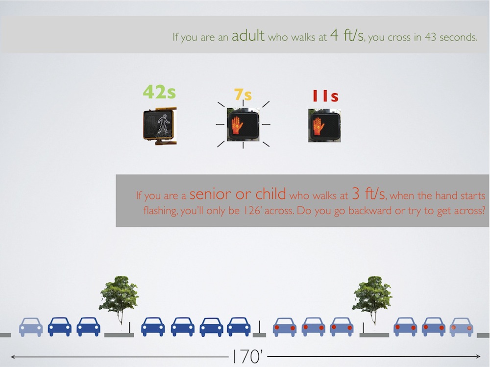
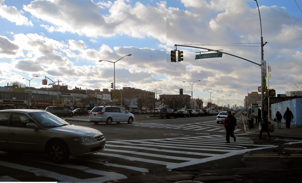
Detail from Planning Corps’ study “Crossing Queens Boulevard: The Effects of Signal Timing at Broadway/Grand Ave”
Late one summer night 2009, James Langergaard — a committed cyclist and a volunteer at Transportation Alternatives (T.A.), a transportation advocacy organization in New York City – was struck and killed on Queens Boulevard as he biked his way home. Because a traffic safety study had been so recently completed, there was little faith among citizens that more could be done to make additional changes to the street. But the community’s questions remained: how many more lives should be lost and put at risk? What could they do right now that could spur on the process for change?
Into this vacuum of viable ideas, T.A.’s Bicycle Advocacy Director Caroline Samponaro introduced the idea of offering realistic alternative cross sections (a flat drawing that shows how a street space is or could be used) to garner support from the public and from city agencies. But T.A., over-committed and cash-strapped, did not have the capacity to execute this idea. It did, however, have a significant asset: an organized volunteer committee of Queens residents who were interested in taking up the cause.
I was working at T.A. at the time, and pondering the role of urban planners in general with Frank. How might we imagine different ways for planners to make use of their abilities to bring about change? Planning processes tend to be drawn out, but community needs tend to be immediate. For example, changes even as seemingly small as traffic signal timing to prioritize pedestrians would require a large study and would need to be initiated by the Department of Transportation. But a volunteer corps of planners could, at a minimum, help draw the cross-sections.

ENTER PLANNING CORPS
From the start, we were curious about what we could accomplish if we deconstructed the process by which planners and non-planners collaborated on a solution. Working closely with the Queens Volunteer Committee, we began with standard problem identification and relied on residents to share their observations and expertise with us. The dedicated volunteers also ran a series of activities to support our research, such as a community walk along the entire length of the Boulevard that documented street design challenges. These observations proved invaluable.
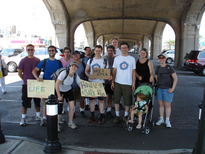
The Queens Volunteer Committee on the Boulevard
The committee’s observations showed that there are actually five basic street and neighborhood contexts for Queens Boulevard, and for each there could be a different solution. A long boulevard that seemed to present new problems on every block and at every unique intersection now required five tailored solutions. This was much easier to digest and conceptualize and mirrored the intent of the neighborhood sub-committees formed by the Queens Chamber of Commerce’s Queens Boulevard Committee in 1933.
We had settled on cross-sections as the major deliverable of our efforts because local non-profit or community groups could express their unique knowledge through the drawn images. In addition, we thought that focusing on one specific product would ensure our ability to deliver good work, and we didn’t want the Queens Volunteer Committee to expect more than we could offer. As we worked, however, we realized that limiting ourselves to cross-sections was impeding our ability to tackle the full scope of the problem.
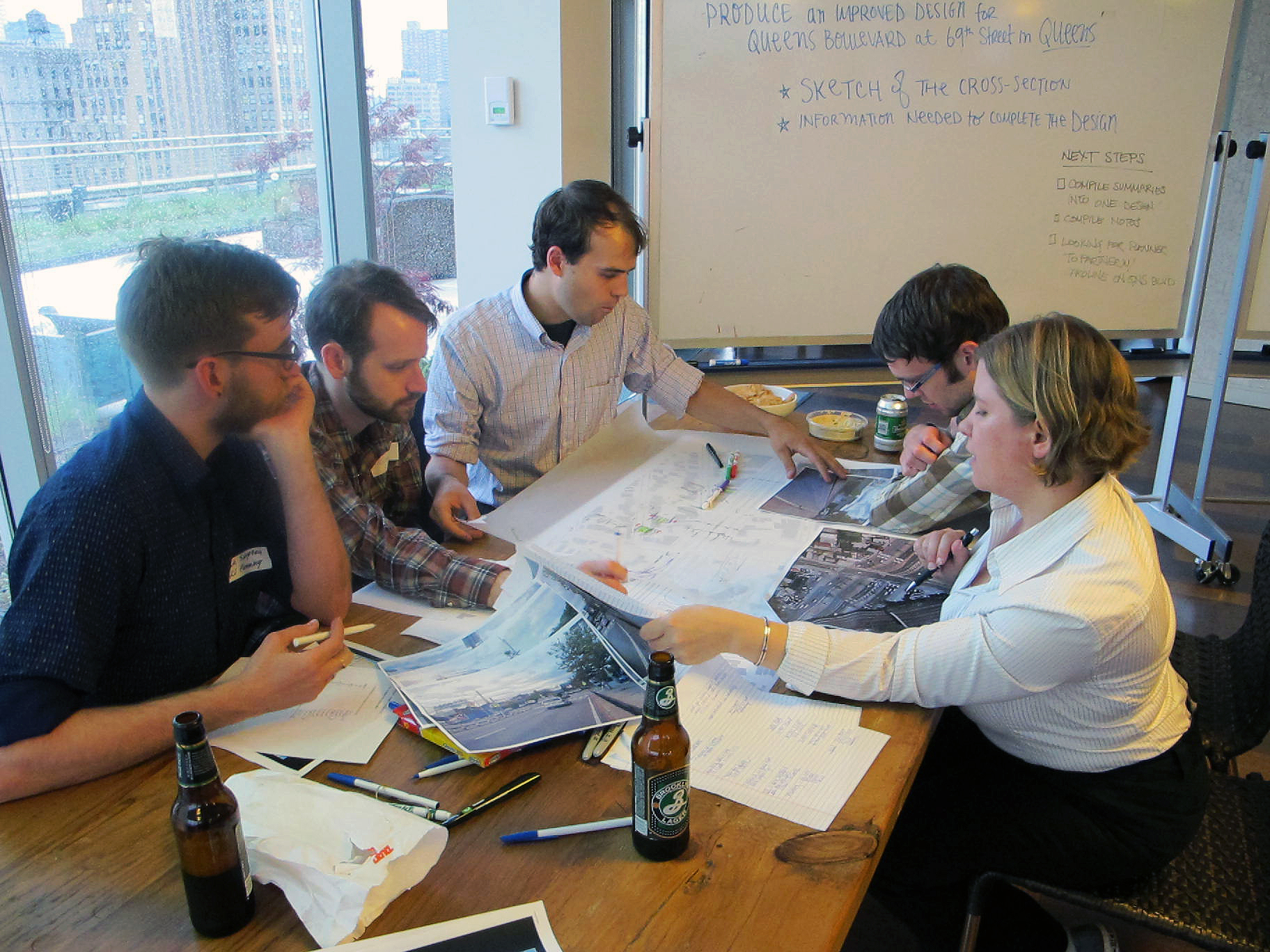
Planning Corps at work | photo: Dory Kornfield
PROCESS, PRODUCTS, PERSUASION
After five months of floundering in this cyclical workshop process and worrying about losing the attention of the Queens Committee volunteers and the volunteer planners, Eric Galipo of H3 Architects, a planner, came onboard. Eric reframed the issue. He asked: What would be the most persuasive way for the Queens Volunteer Committee to persuade their elected officials that something had to be done to the street?
Reframing our process made the flow of activity needed to build up to the demand for change more legible. Instead of fixating our time on producing a product, we became more aware of the questions at large and how the community would have to answer them to build support for the changes they wanted. We started to ask more specific questions about who the volunteers would need to talk to and what would help them make their arguments.
Typically these questions are answered for planners by a city or industry’s framework, for example, the Uniform Land Use Review Process in New York City for land use zoning changes. Developers work off of pro formas and in-house economic models that support development proposals. To make changes to Queens Boulevard, we needed to intervene in the City’s formal planning process for transportation capital improvements.
We determined that it was be the elected officials who needed to be convinced to set aside public funding for another traffic safety study. Elected officials are not usually trained in street design and they are usually short on time. The question every elected official had to field in public was how more space for bicycles would fit on a boulevard that experiences so much congestion already. Cross sections of street space allocation would be useful, but perhaps more useful if they were presented in a collection of boulevard cross sections taken from around the world – boulevards that had demonstrably fewer crashes. Mike Lydon, the founder and principal of the Streets Plan Collaborative, found examples of boulevards that matched the typology of Queens Boulevard but were demonstrably safer and served multiple modes. Eric helped reorganize the detailed information to demonstrate comparisons that support the concept that it is possible to redesign the street.
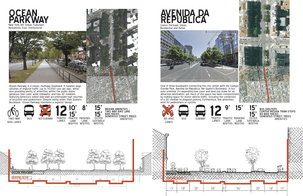
Two comparable boulevards from Planning Corps’ Book of Precedents
Most street typology books force the reader to draw mental comparisons, but we could not afford to lose the attention of our target in that way. Given that the volunteers would be trying to start conversations with people who might not be disposed to having the conversation in the first place, the comparisons would have to be immediate, visual, and clear. Anthony Denaro from OpenPlans took all the content, worked out the necessary information design keeping all of these concerns in mind, and formatted them into a booklet.
Additional themes that surfaced during the original problem identification became starting points for other products. They included topics such as how much businesses would be impacted, and why it’s so hard to convince people that signal timing can make a big difference for pedestrian safety. The main question that persisted was how all of the desired safety improvements for multiple modes could fit in the existing space of Queens Boulevard.

For example, to show a non-transportation specialist the basics of geometric street design, we finally arrived at what we called the “Julia Child Street Kit Model.” H3 Architects has a history of creating models that show clients the trade-offs between possible uses for a space and the constraints. These models of different parts can be combined in multiple ways to make different plans and programs, just as the ingredients and tools in Julia Child’s kitchen can be combined to create different dishes.
For instance, a new theater building may require a certain number of parking spots. The cheapest way to provide parking is through a surface lot. But this is also the most expensive in terms of land acquisition. Underground parking is more expensive in labor and materials, but much cheaper in terms of land and opportunity cost for that land. The Julia Child Kit allowed the designer to trade surface parking for structured parking on a model.
We made a huge list of street elements – bus lane, bike lane, parking, travel lanes, wider sidewalks, curb extensions, and street trees. Eric laid the pieces out in CAD (Computer-aided Design) and mounted it on foam core. Then we spent a few hours cutting them out. Once you have your pieces ready, you can line up all the pieces to represent the existing street; move the pieces around and take out a travel lane; add a bike lane and sidewalk extension as you see fit.
Dealing with small business owners who continuously feel threatened by any traffic or street design changes – as they have every decade since Queens Boulevard has experienced safety issues – was another significant challenge. We asked the volunteers, what would you like to have with you when you talk to them? How would you convince them? What would give you confidence to have that conversation? We had trouble imagining small business owners reading a report that provided evidence of the economic benefits of a more pedestrian and bicycle-friendly street so we did not conduct a literature review. Instead, we created an informal text document that listed common questions and a few possible answers. We listed resources and studies at the end of the talking points, in case anyone was so inclined to read more.
Over the course of our collaboration with the volunteer planners and community members, we did not produce anything that could be called new in terms of design. Our innovations were limited to reframing questions, discussions and tasks, and to designing the products to meet identified needs. Our discussions enriched our understanding of what was involved in seeking the urban change, and the products followed suit.
It is worth noting that we had the luxury of time. One could say that we ended up with typical planning products and we just took the long way around to it. Yet it is hard to imagine the group of us knowing from the beginning that we should build a street model kit, write talking points on economic benefits, or design a book of boulevards, without first having had all those discussions that revealed the layers of actors and information, and connected the points of engagement. Community members seeking drastic design changes on Queens Boulevard needed to deal with multiple stakeholders in their campaign to build public support, and each stakeholder group required a different approach and thus individual tools. Though we never lost sight of the ultimate goal – winning safer, more livable street design changes for Queens Boulevard – the deconstructed framework allowed us to experiment and hopefully end up with better tactical results.
Queens Boulevard, 2010 | photo: Flickr user Haruko16
Planning Corps continues to welcome members and is especially interested in planners who are enthusiastic about committing to more leadership. Sign up here or contact Shin-Pei Tsay if you’d like to learn more.
Unless otherwise noted, all images courtesy of Planning Corps.
An earlier version of this article appeared on CoLab Radio.
The views expressed here are those of the authors only and do not reflect the position of The Architectural League of New York.

Comments