


Series
Studio Reports
Student research and propositions from design studios with real-world implications.
We are celebrating 15 years — and counting — of stories that are deeply researched and deeply felt, that build a historical record of what the city has been.
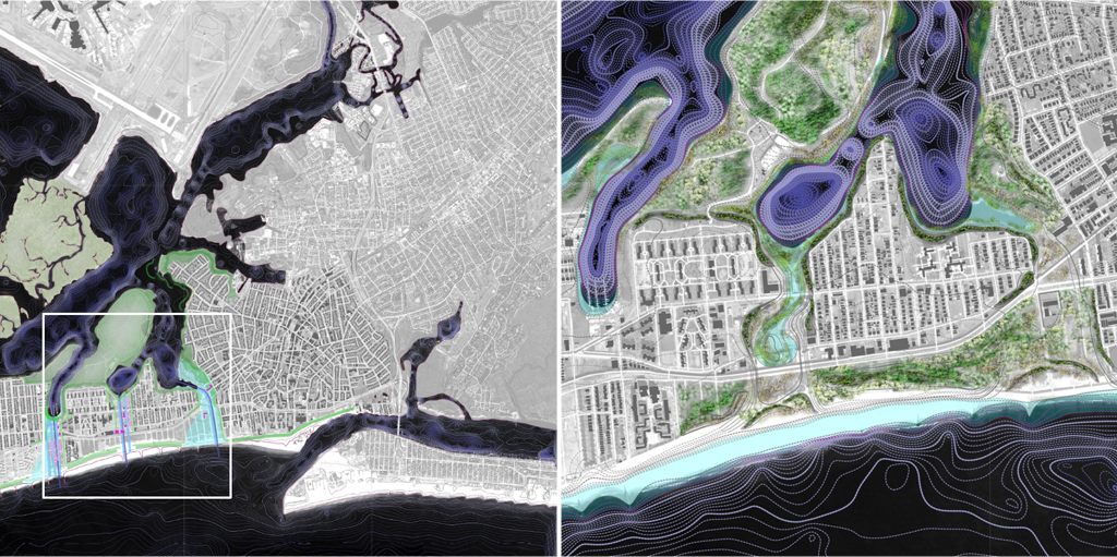
When crucial infrastructure, scale, and environmental and social vulnerability coalesce as they do in and around Jamaica Bay, the profusion of attention the bay has attracted comes as little surprise. And while the regional importance of the bay’s rich ecosystem has long been recognized, the heightened urgency of coastal protection post-Sandy and intensifying ecological loss in the bay in recent years has prompted renewed study of the area. Academic studios, among them Chris Reed’s studio on landscape-based urbanism for back bay and Rockaway peninsula communities, and professional architects alike have sought to articulate new visions of the bay that harness its potential as a keystone in the metro region’s approach to a future heavily influenced, if not defined, by rising sea levels and stronger storms.
Landscape architect Catherine Seavitt, along with her team at the City College of New York, take those approaches to Jamaica Bay a step further as part of the larger Structures of Coastal Resilience study, which includes three other East Coast bays attended to by university-based teams. As Seavitt explains, her studio follows a growing trend in the field of landscape architecture toward experimental and science-based design processes and active participation in policy discussions. The Structures of Coastal Resilience initiative parallels and hopes to inform the work of the US Army Corps of Engineers, which delivered a massive study to Congress today on possibly paradigmatic shifts in the methods the country’s public engineers use to protect coastal communities and promote ecological health in our waterways. Here, Seavitt delves into the process of her experimental research studio, presents adaptive design strategies that merge ecosystem restoration with infrastructures to protect bay communities, and explores the potential of this model for informing official approaches to coastal management. –J.T

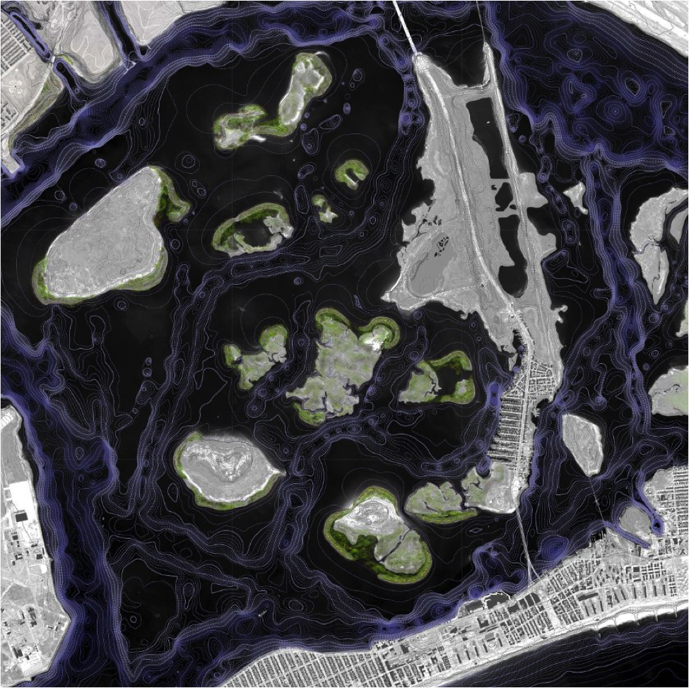
Jamaica Bay, featuring the adaptive design strategies proposed by the Structures of Coastal Resilience City College of New York team
Since Hurricane Sandy’s landfall along the Atlantic seaboard in October 2012, the word “resilience” has loomed large in coastal communities and government agencies. Former New York City Mayor Michael Bloomberg was quick to organize the Special Initiative for Risk and Reconstruction (SIRR) to assess the City’s preparedness for future storm events, climate change, and sea level rise, resulting in a 445-page report released in the summer of 2013. At the national level, Congress tasked the US Army Corps of Engineers (USACE) — the public engineers responsible for disaster risk reduction, environmental regulation, and the execution of civil engineering projects — with preparing a detailed study of possible futures of the Sandy-affected eastern seaboard, from Virginia to Maine.
This $19.5 million study, titled the North Atlantic Coast Comprehensive Study was delivered to Congress and publicly released today, January 28, 2015, after much anticipation among interested parties. Given the thickness of past USACE reports, a document in preparation for over two years promises to be even heavier than the SIRR. Perhaps one of its most interesting aspects will be an examination of what it terms natural and nature-based features and their integration into USACE’s lexicon of risk reduction measures. The USACE has long relied upon hard infrastructures to control erosion and protect communities from flooding. But criticisms of this approach abound. The failures of USACE coastal and riverine flood control structures during Hurricane Katrina was a massive wake-up call, and Hurricanes Irene and Sandy brought this concern from the Gulf Coast to the eastern seaboard. The inclusion of nature-based features — among them dunes, oyster and coral reefs, barrier islands, maritime forests, and wetlands — marks a radical paradigm shift. For USACE, it’s not about flood control any more, nor is it about flood protection. Now, the concern is management of risk, hence the adoption of coastal storm risk management as the new guiding nomenclature for the organization.
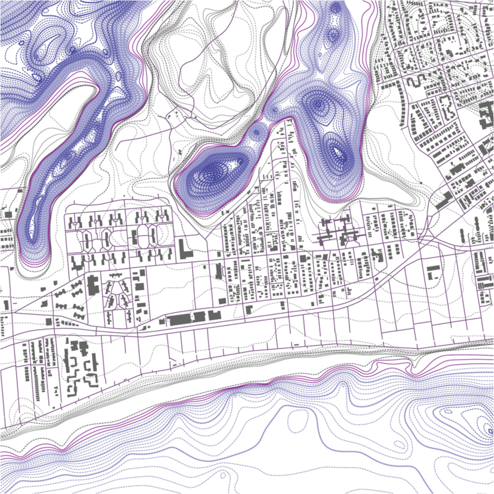
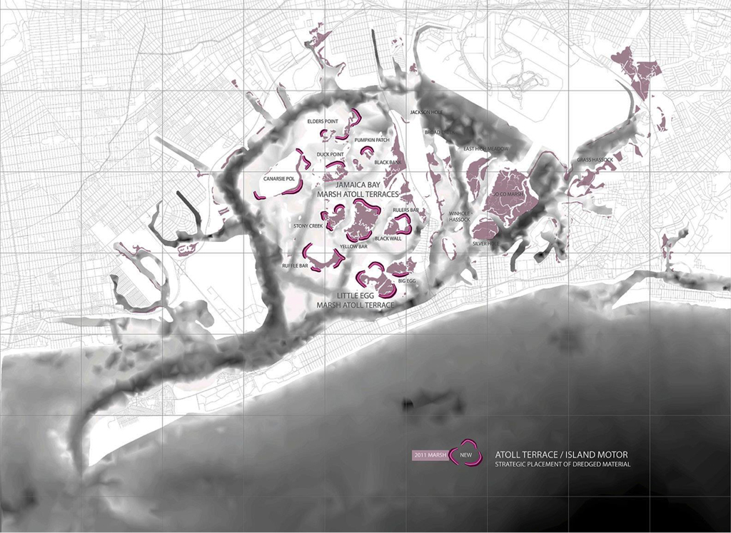
Marsh islands at Jamaica Bay, augmented with the City College adaptive strategy of the atoll terrace / island motor
The benefits and performance of natural features often increase with scale. That is perhaps the most invaluable quality of Jamaica Bay, New York — the study site of our City College of New York research team for Structures of Coastal Resilience. This 18-month multi-university collaborative study is working to design for resilience in four coastal bays within USACE’s study area in parallel with the Comp Study’s schedule. Our hope and intention is that these academic studies, and the design thinking they have engendered, will influence USACE’s approach to risk management going forward. Though the work of Structures of Coastal Resilience is not officially part of the Comp Study, ongoing discussions with members of USACE and their generous reality checks have informed our research, helping to reframe our thinking on resilience and to push us outside the comfortable niche often occupied by designers.
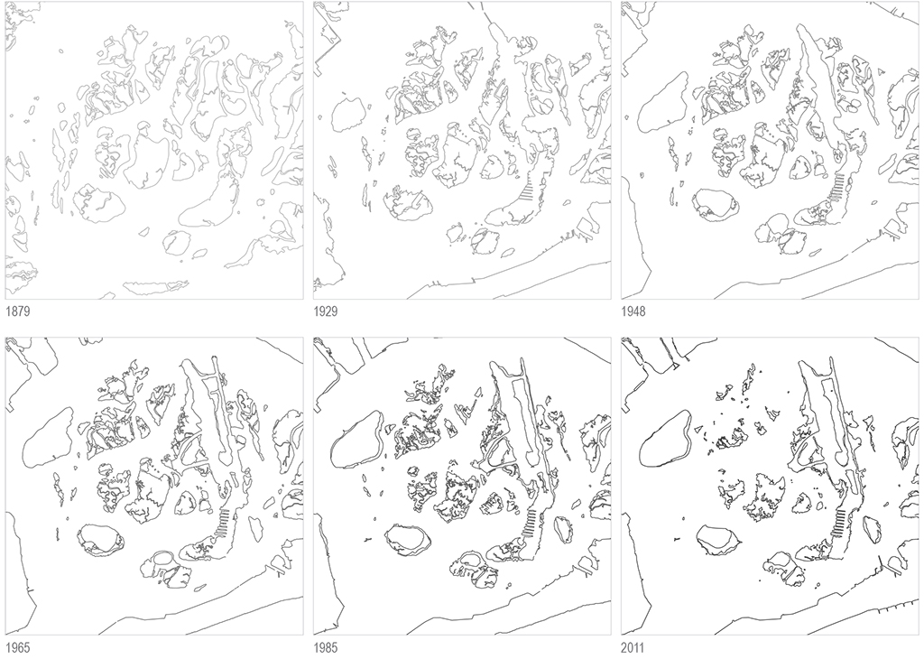
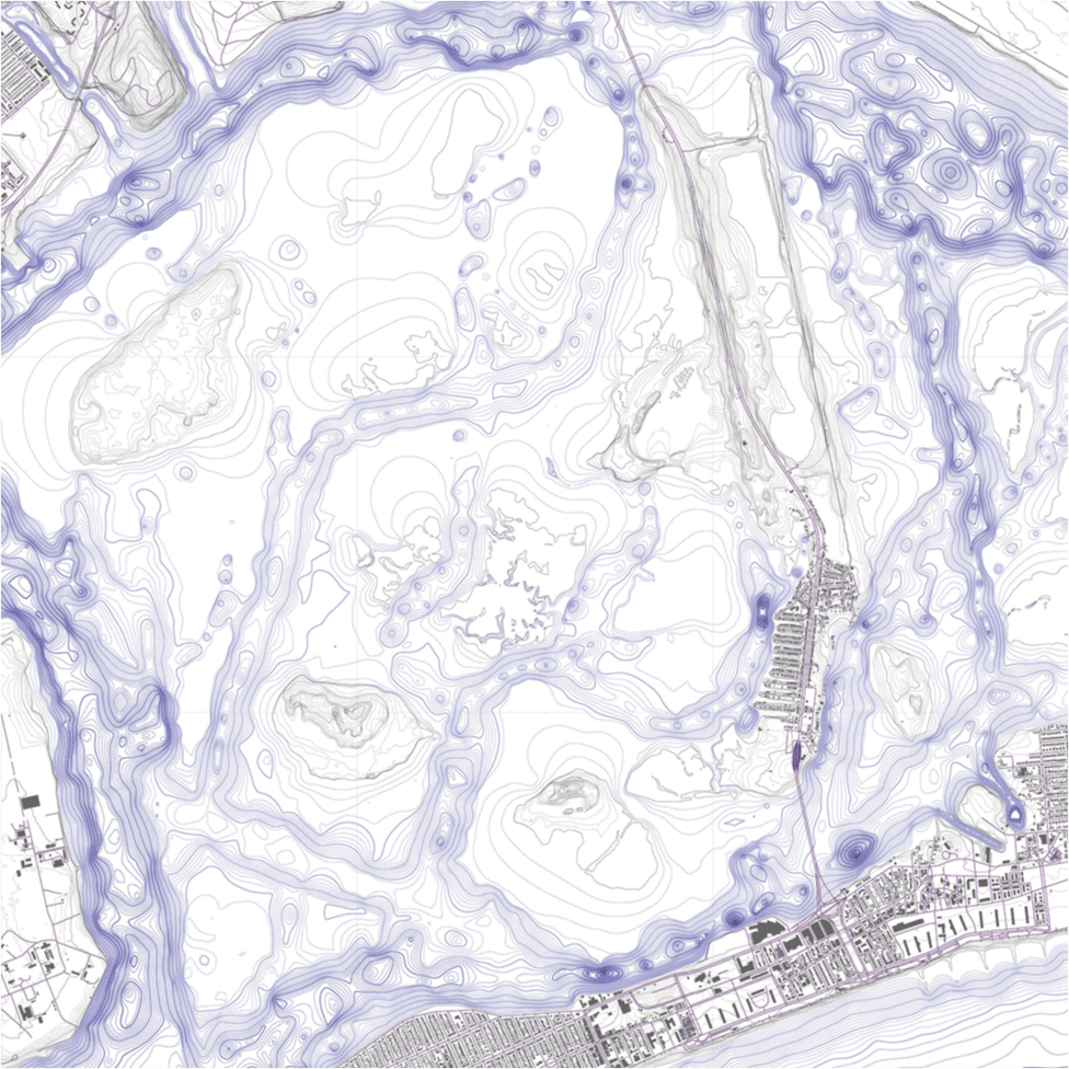
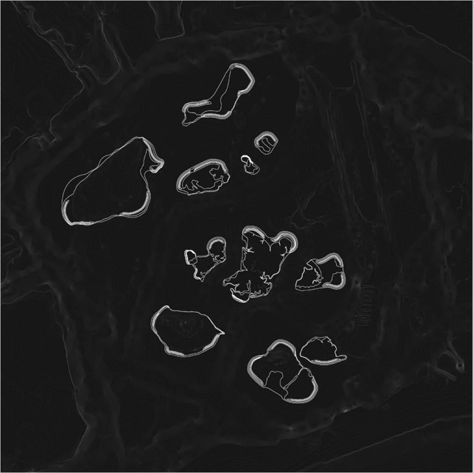
Diagrams of the transforming shorelines of Jamaica Bay’s marsh islands, from 1879 to 2011
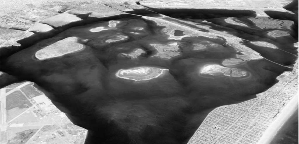
Jamaica Bay is a fantastic site for study, particularly as it has been closely scrutinized by USACE and others for decades. The bay also has its fair share of historical and contemporary challenges. The Rockaway peninsula and back-bay communities experienced significant damage from Hurricane Sandy’s surge and the extensive flooding that followed. The bay, with its position at the bottom of the urban sewershed, has been environmentally challenged since its early days as New York City’s dumping ground. And since the 1970s, marsh loss within the bay has severely increased due to the combined anthropogenic impacts of poor water quality, erosion, and sediment starvation.
Yet because of its relatively vast scale in the footprint of New York City, Jamaica Bay has the potential to be transformed as an ecological, infrastructural, and community asset — an anchor of the region’s resiliency. For USACE, Jamaica Bay provides an incredible opportunity for exploring the performance of nature-based features, particularly salt marshes, maritime forests, and dunes. The bay is a dynamic ecological entity — a sandy, shifting terrain geologically capable of functioning resiliently during and after disturbance events. The adaptive design proposals for Jamaica Bay that we’ve developed seek to enhance that capability while also addressing social, environmental, and infrastructural vulnerability in the area.

Detail of the City College topobathy water tank model of Jamaica Bay, looking northeast past Breezy Point and Rockaway Inlet
An Experimental Research Studio in Process
Our City College team* may be situated within the Spitzer School of Architecture and affiliated with the landscape architecture program, but ours is not your traditional academic studio. Rather, it is an experimental research studio that reflects the expansion and evolution of landscape architecture as a STEM (Science, Technology, Engineering, and Mathematics) or STEAM (add an A for Arts) discipline, a trend recently recognized by many educators and practitioners.
We’ve modeled our studio after the Waterways Experiment Station — USACE’s hydraulics research laboratory facility in Vicksburg, Mississippi, that is the historic home of large-scale physical models of the Mississippi River, Chesapeake Bay, and New York Harbor used to test flood control structures and the effects of longshore drift, or sediment travel along coastlines.
Our lab reflects USACE’s continued use of such physical hydraulic models amid a substantial shift to digital modeling. Our physical models range in scale from the breadth of the watershed to the detail of a marsh platform, resulting in a deep understanding of the geomorphology, or physical landforms, of the bay. With six water tank models, we are able to test the dynamic conditions of water flow, overwash, sediment deposition, and surge. The hydrodynamic effects produced are somewhat rough, but the precision of our Jamaica Bay topobathy model — which merges topographic (land) and bathymetric (water depth) data — allows us to study design scenarios through subtle, iterative physical transformations. These water tank models are cast in glycerin, a forgiving material which allows us to make quick manipulations to the topobathy during the flow experiments. And the empirical results we’ve captured through video of these models in action have provided integral feedback to our design process.
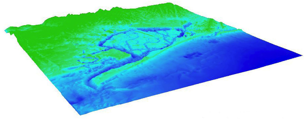
Oblique view of the digital elevation model showing the topobathy of Jamaica Bay
In the digital realm, we’ve built a highly refined digital elevation model of the topobathy of Jamaica Bay. We pair this digital elevation model with hydrodynamic modeling tools such as the SLOSH (Sea, Lake, and Overland Surges from Hurricanes) model, SLAMM (Sea Level Affecting Marshes Model), and the wave generator tool WAVES2012 to analyze the efficacy of our proposals by comparing the bay’s existing condition with a speculative bay featuring our design modifications.
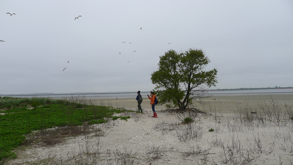
Catherine Seavitt and Kjirsten Alexander at Little Egg marsh island among laughing gulls on May 5, 2014.
But getting out of the lab to ground-truth — in tall rubber boots with GPS in hand — is critical. It’s a 90-minute A-train ride from City College in Harlem to Broad Channel, Queens, that unexpected community on a marsh island in the middle of the Bay. Like Jorge Luis Borges’ fabled one-to-one map of the kingdom, Jamaica Bay itself is a full-scale research lab replete with local environmentalists who’ve been instrumental in our work. We walk to islands during extreme low tides. We time our visits with the incoming tides to access back-bay inlets by boat, with the mean tides for quadcopter overflights, and with unnaturally high tides for surveying flooded streetscapes in Howard Beach. Observing currents and mapping low and high tide lines in the marshes allow us to identify the ideal locations for elevated terraces that would enable sediment trapping, one of our design strategies.
Our Pamphlet Library, consisting of sixteen topical pamphlets and three reference manuals, acts as a structured repository for the data we’re accumulating. We were inspired by both the “semiotext(e)” model of carefully curated translations of French philosophy and the low-tech hand-printed-and-folded “cordel” literature and poetry of the northeastern Brazilian troubadours. Some pamphlets compile aerial imagery, some are photographic field notebooks, and others contain our collection of coastal infrastructural inventions. Most address the complex cultural, ecological, and infrastructural systems of Jamaica Bay and, as a set, they comprise the thoughts and research that influenced and informed our resiliency strategies for the embayment.
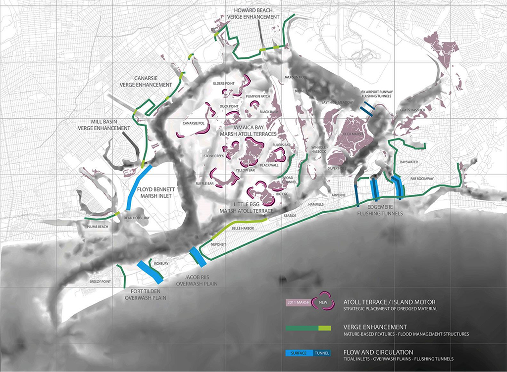
The City College team proposes numerous strategic interventions at Jamaica Bay based on three strategies: Flow and Circulation, Verge Enhancement, and Atoll Terrace / Island Motor
Adaptive Design Strategies for Jamaica Bay
Our team’s strategic design recommendations for supporting coastal resiliency at Jamaica Bay include three interrelated strategies that merge novel techniques of ecosystem restoration with layered nature-based features.

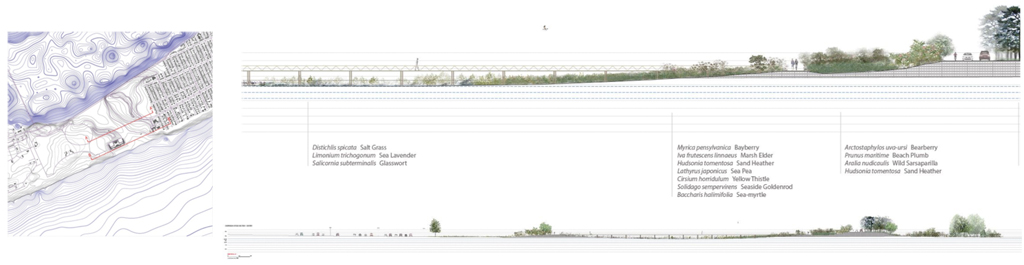
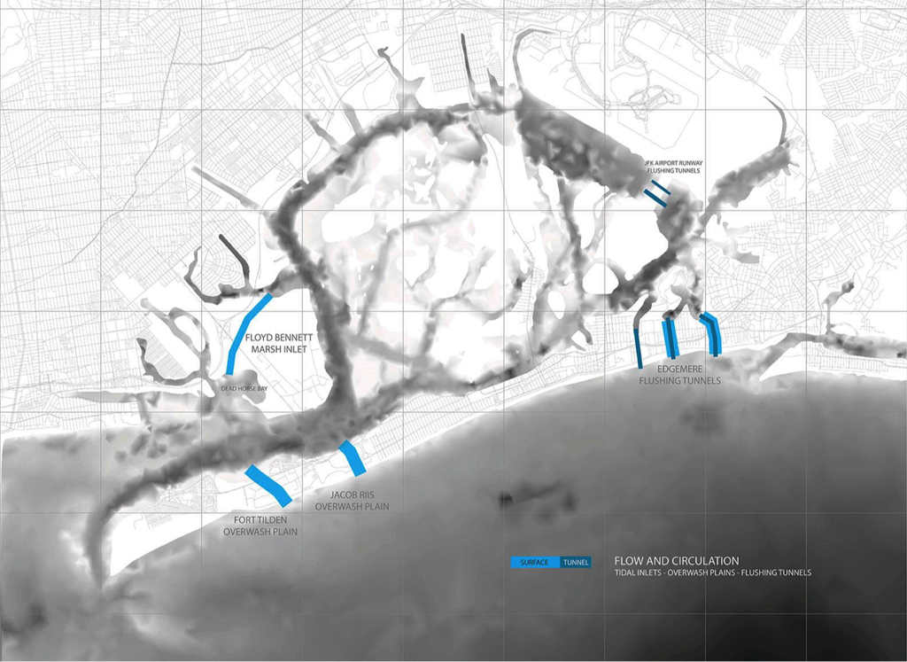
Click here to view more images and animations illustrating the Flow and Circulation strategy | Rendering of a proposed overwash plain at Jacob Riis Park
1. Flow and Circulation
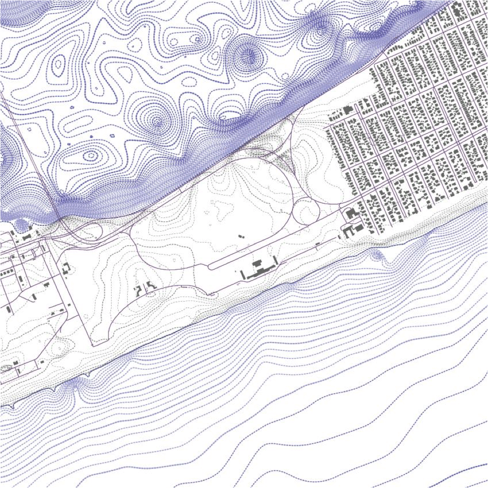
We aim to improve water quality and support ecological health through a more rapid exchange of waters from the bay to the ocean by enabling overwash, the transfer of water and sediment across a barrier island to a bay during extreme high tides and storm events. This is achieved via a series of designed overwash plains, tidal inlets, and flushing tunnels on the Rockaway Peninsula and across the northern extents of Floyd Bennett Field. At Edgemere, a neighborhood with a relatively dense building footprint near the eastern end of the Rockaway Peninsula, we include both below-grade flushing tunnels and above-grade flow paths to improve circulation and to provide a controlled trajectory for periodic floodwaters. At the western end of the peninsula, amid the open space of Jacob Riis Park and Fort Tilden, we propose very shallow tidal inlets and overwash plains to allow for sediment delivery from ocean to bay, supporting the nourishment of the restored wetlands and accretion of marsh islands.

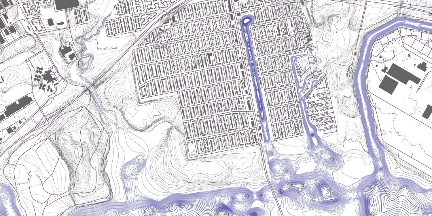
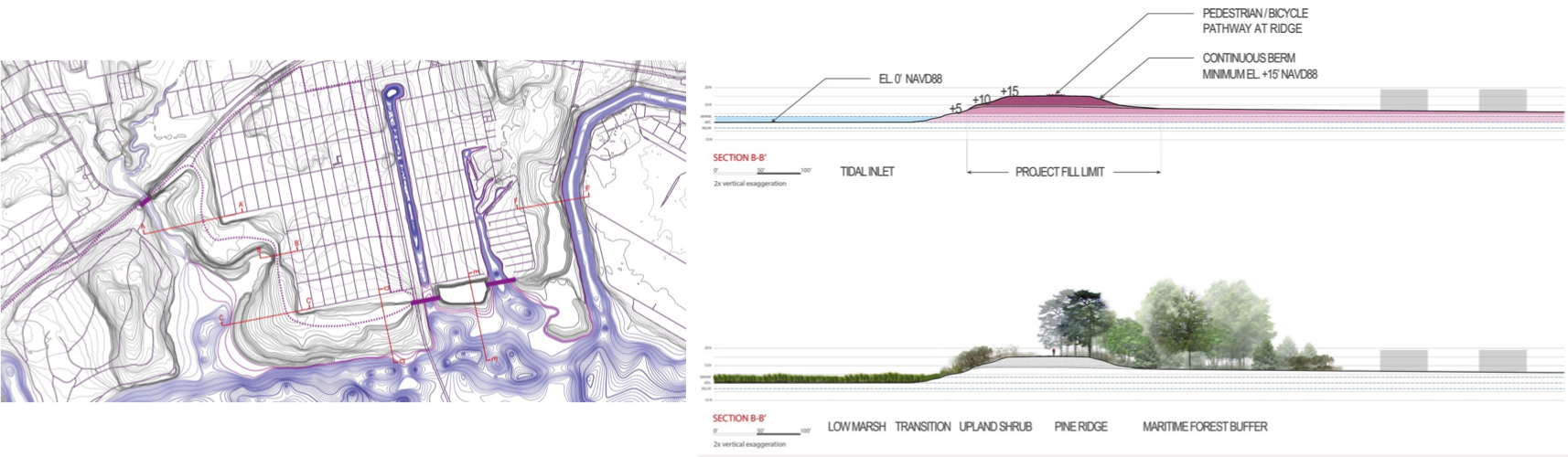
Click here to view more images and animations illustrating the Verge Enhancement strategy | Diagram of proposed elevational increases along the Belt Parkway to protect back-bay communities
2. Verge Enhancement
Second, by enhancing the verges of the Belt Parkway and elevating coastal edges at vulnerable back-bay communities, we can manage flood risk via a layered system of marsh terraces, berms, and sunken attenuation forests. Howard Beach, a low-lying back-bay community that experienced extensive flooding during Sandy and regularly floods during high tidal cycles, is protected by a continuous berm created from existing high ground at the southwest to the landing of the Belt Parkway bridge over Spring Creek. The verges of this transportation network are recast as an elevated buffer with the capacity to provide the entire community with protection from waters with the equivalent height of FEMA’s current 100-year base-flood elevation plus two feet of “freeboard.” These enhanced verges are foregrounded by low marsh, high marsh, and upland planting zones, providing additional mitigation of wave energy as well as public space at the waterfront. Densely planted sunken maritime forests are established behind the berm to provide attenuation and absorption of floodwaters in the event of overtopping.
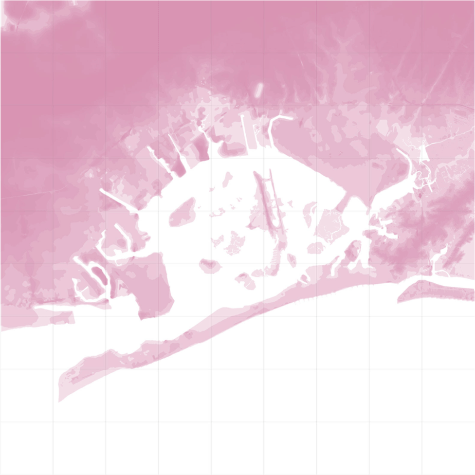
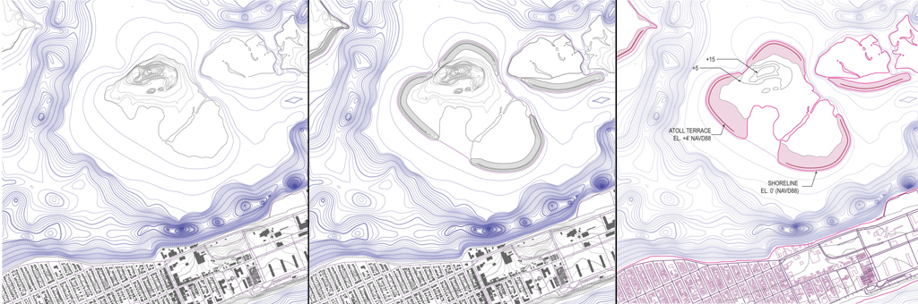
Click here to view more images and animations illustrating the Atoll Terrace / Island Motor strategy | Diagram of marsh island contours in Jamaica Bay with the proposed introduction of elevated terraces along their edges
3. Atoll Terrace / Island Motor
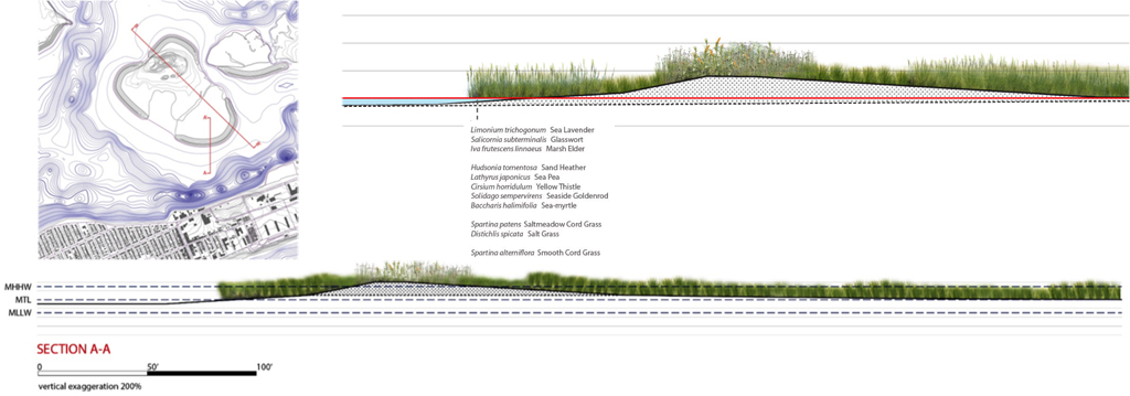
Third, the implementation of novel strategies of bay nourishment and salt marsh island restoration can maximize the potential of the beneficial placement of dredged material that is already underway in the bay. Salt marsh loss at Jamaica Bay is a paradigmatic example of environmental vulnerability, particularly given future sea level rise. A resilient marsh ecosystem provides coastal storm risk management services to adjacent communities through wave attenuation and the reduction of fetch, the unobstructed distance of open water across which waves are generated by wind. Our strategy for sand placement requires less sediment, but would distribute this valuable resource over a greater area of the marsh platform. We have strategically placed minimal quantities of dredged material as “atoll terraces” at the perimeter of the marsh island footprints to best capture sediment based on current speeds, tidal flows, and sedimentary transport. By harnessing this “island motor,” natural processes of current-driven sediment capture and deposition will nourish the marsh and allow it to accrete upward with sea level rise. The atoll terrace’s gradient section provides an ideal slope for the upward migration of low marsh grass given sea level rise and creates conditions for achieving the water clarity and light penetration required for the successful establishment of marsh grasses and submerged aquatic vegetation.

Animation of the digital topobathy model of Jamaica Bay showing existing conditions and proposed interventions
A Framework for the Future
This adaptable framework for a resilient Jamaica Bay responds to future sea level rise and storm risks while sustaining the co-existence of nature and culture. But it also begs for further research, and for pilot projects that begin to capitalize upon its potential. Because of their interdisciplinary and multifaceted nature, we expect our strategies to find interested parties among city, state, and federal regulators, designers, and environmentalists alike.
While there are no concrete plans for implementation at this time, our research team remains firmly optimistic that the support of nature-based features emerging from Vicksburg reflects the beginnings of a radical paradigm shift at USACE, and of their embrace of such strategies going forward. One post-Sandy USACE report argues that recent marsh island restoration projects at Jamaica Bay effectively reduced the potential for erosion that threatens the critical infrastructural evacuation route provided by the Cross Bay Boulevard’s North Channel Bridge. This speaks to our contention that the future success of the marsh islands is truly an infrastructural argument, rooted in plant morphology. With wetter and warmer climates coming, the nature of the plantings too calls for further exploration — imagine plant selections that are truly resilient, including submerged aquatic vegetation and low marsh species that tolerate these warmer waters. The collaborative design research of Structures of Coastal Resilience — in its dialogue with governmental agencies and community NGOs for critical feedback as well as a commitment to remaining experimental, innovative, and non-partisan — is forging new territory in landscape architecture. And it’s a model worth further pursuit as we explore what a resilient future actually looks like.
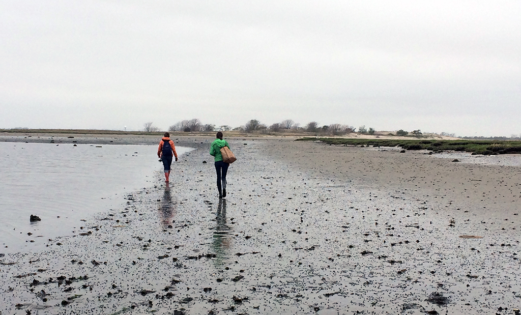
Kjirsten Alexander and Danae Alessi walk out into the bay to Little Egg marsh island during a very low tide on May 5, 2014.
* In addition to the author, the Jamaica Bay team includes Kjirsten Alexander, City College Master of Landscape Architecture, class of 2012; Danae Alessi, City College MLA, class of 2013; and Eli Sands, who will graduate with an MLA in May 2015.
To learn more about the City College of New York team’s proposals and those of the three other university teams that comprise Structures of Coastal Resilience, visit the SCR website.
The author would like to thank Don Riepe, the Jamaica Bay Guardian and director of the American Littoral Society’s Northeast Chapter, for his knowledge, multiple exploratory boat rides, and access to his photographic archive of Jamaica Bay; the EcoWatchers Dan Mundy Jr. and Dan Mundy Sr., for sharing their knowledge of marsh island restoration in the bay; Peter Weppler, Chief of the Environmental Analysis Branch, and Lisa Baron, Project Manager of Civil Works, of the USACE New York District; Marit Larson, Jamie Ong, and Ellen Hartig at New York City Department of Parks and Recreation’s Natural Resources Group; John McLaughlin at the New York City Department of Environmental Protection; Stephen Zahn and Joanna Field at the New York State Department of Environmental Conservation; Joshua Laird, Jennifer Nersesian, and Mark Christiano at the National Parks Service’s Gateway National Recreation Area; and especially Guy Nordenson, project director of Structures of Coastal Resilience. The Structures of Coastal Resilience project was made possible by the generous support of The Rockefeller Foundation.
The views expressed here are those of the authors only and do not reflect the position of The Architectural League of New York.
Student research and propositions from design studios with real-world implications.
Comments