
We are celebrating 15 years — and counting — of stories that are deeply researched and deeply felt, that build a historical record of what the city has been.
We are celebrating 15 years — and counting — of stories that are deeply researched and deeply felt, that build a historical record of what the city has been.
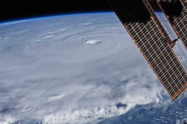
Hurricane Earl | NASA photo via Flavorwire.
Hurricane Earl is coming! Or at least passing by. Though early reports stated that the storm might hit New York City hard, current forecasts are far less ominous. But maybe we shouldn’t rule out landfall yet. BLDGBLOG tells us that cities might actually attract passing hurricanes due to the jagged topography of urban landscapes. The irregularity of city land cover can result in an air vortex of sorts that can cause storms to veer up to 20 miles off course. With any luck, our potential vortex will stay quiet and keep Earl at bay, since disaster specialists are concerned about New York’s hurricane readiness. City residents don’t consider major storms a realistic threat so preparations would likely be insufficient and the aftermath could be crippling. Flooding would allow saltwater to permeate major infrastructure systems and cause long-term damage and shut-downs even after the storm passed.
Hurricane speculation is just one of many reminders of the vulnerabilities of our infrastructure. Last week, a fire that disrupted the commutes of over 100,000 LIRR passengers was caused by a fire in an “obscure contraption of levers and pulleys” which dates back to the early 1900s. New York is not alone — The New York Times spotlights five major infrastructural systems from across the nation that could be brought down by anything from simple wear-and-tear to burrowing squirrels. Meanwhile, Grist points out that our international systems can be equally unstable, particularly our global food systems, a problem that has motivated many, from community coalitions to government officials, to encourage more localized foodsheds that will improve food security, sustainability and local economies — a challenge that involves land tenure, zoning issues, waste management, urban agriculture and more.
Situ Studio is at it again. The impressive team of Brooklyn designers and digital fabricators, who apply their skills and knowledge to everything from the Guggenheim exhibit Frank Lloyd Wright: From Within Outward to a forensic investigation into the killing of a demonstrator on the West Bank, has now teamed up with Princeton University geoscientist Adam Maloof to develop 3D digital reconstructions of fossilized sponges — which might sound boring until you consider that the sponges may be the earliest known form of animal life. Situ’s Bradley Samuels touched on the potential implications of their work for T Magazine: “For Situ Studio, the most exciting aspect of this collaboration is that we were able to successfully employ knowledge developed within an architectural practice to help solve problems in an entirely different field by applying design tools to spatial problems on a completely different scale.” Exactly.
Let’s say you decided to move out of New York City. Where would you go? Or, when you moved here, where did you come from? And why? Brian Lehrer posted those questions to his WNYC audience and then launched Map Your Moves, a migration pattern data visualization challenge using the responses. WNYC has fifteen submissions posted on their site, which range from the humorous to the downright stunning. And FlowingData takes a closer look at Moritz Stefaner’s interactive map and Andrea Stranger’s series of posters.

Screen grab from Map Your Moves by Moritz Stefaner
We recently heard Dan Doctoroff discuss his tenure as Deputy Mayor for Economic Development as part of the League’s Conversations on New York series. Though Doctoroff left office in 2007, projects he launched continue to shape the conversation about our city’s future. This week, City Limits offers a status report for some of Doctoroff’s most notable projects, including Hudson Yards, Bronx Terminal Market, and the rezonings of Downtown Brooklyn and Williamsburg/Greenpoint.
Last year, we played around with Museum of the Phantom City, an iPhone app which acts as a mobile, living museum of visionary, unbuilt designs for New York City. Now, there is a new app that serves as a portable encyclopedia of built architectural projects around the globe, which you can browse by location, material, architect, program, and more. OpenBuildings.com, the community-driven architectural directory, started the app, simply called Buildings, as a mobile travel guide for architecture enthusiasts. iPhone users can download the app for free to gain access to detailed information, photos, sketches and technical drawings. You can also contribute your own photos or videos to existing entries straight from your phone. Word on the street (or, more accurately, in some comments) is that an Android version is on the way. Sounds like a great excuse to explore the city over the long weekend.
The Roundup keeps you up to date with topics we’ve featured and other things we think are worth knowing about.
The views expressed here are those of the authors only and do not reflect the position of The Architectural League of New York.