
We are celebrating 15 years — and counting — of stories that are deeply researched and deeply felt, that build a historical record of what the city has been.
We are celebrating 15 years — and counting — of stories that are deeply researched and deeply felt, that build a historical record of what the city has been.
Public thoroughfares often endure longer than the private property alongside them, and sometimes outlive even the cities and towns that they service. But the history of roads — the infrastructural priorities, demographic realities, technological possibilities and urban development choices that they reveal — gets less air time than other elements of city form, like civic buildings, public monuments or private houses. But for Gabrielle Esperdy — an architectural historian whose work examines the intersection of American architecture, consumerism and modernism in 20th and 21st century urban and suburban landscapes — certain streets offer an opportunity to summon a variety of historically distinct architectural and planning philosophies and to discuss them in a single setting. Flatbush Avenue, one of the oldest and longest streets in Brooklyn, is such a street. Just as the line of Broadway attests to pathways through Manhattan traversed long before Europeans arrived, Flatbush bears the marks of the Revolutionary War, Beaux Arts planning, and, of course, Robert Moses. Below, Esperdy recounts a journey from the Manhattan Bridge to Jamaica Bay. –C.S.
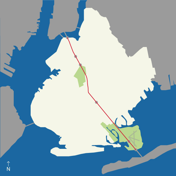
The path of Flatbush Avenue from the Manhattan Bridge to Jamaica Bay, passing sites indicated: Juniors, Grand Army Plaza, Prospect Park, Flatbush Junction, Marine Park and Floyd Bennett Field | Image by Daniel Rojo
Stay on Flatbush Avenue long enough in either direction and eventually you hit water, but it wasn’t always like that. One of Brooklyn’s oldest streets, Flatbush Avenue used to be landlocked. In the 17th century, it was a country lane. Built over a Native American footpath, it connected disparate Dutch farming villages, including Vlacke Bos, from which the avenue takes its name. Back then, it would have been hard to imagine that such a sleepy road would become such an all-important, trans-borough thoroughfare, one that would grow along with Brooklyn itself, mirroring its development for more than 350 years of ongoing settlement, congestion, decay, renewal and reimagining.
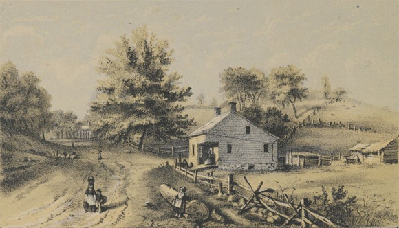
Battle Pass, Valley Grove | Lithograph by Hayward and Lepine, ca. 1866, via the online collection of Brooklyn Museum
In the 18th century, the Flatbush Road was sufficiently improved, so much so that it required serious defense during the Battle of Long Island. The Americans held the pass against the Hessians – German soldiers hired by the British to protect the American Loyalist cause – thanks to the trunk of an enormous oak, but the British attacked from the rear and the patriots went down in defeat.
In the 19th century, Flatbush assumed close to its present route, inland through the heart of what was not yet completely the City of Brooklyn (those Dutch villages didn’t allow annexation until around 1895). This work was conducted under the auspices of the Jamaica and Brooklyn and Flatbush Plank Road Companies, authorized by the State Legislature to collect tolls on the Flatbush Turnpike. A consolidated company continued toll collecting until it went out of business in 1893.
It was only in the 20th century that Flatbush became the ten-mile long, multi-lane, traffic-choked corridor it is today, its extensions towards the water coinciding twice more with the ambitions of the expanding metropolis.

Junior’s at Dusk | photo by Jim Henderson
Driving on Flatbush on a typical Saturday night, it often seems as if the only reason they built the segment from Fulton Street to the East River was to accommodate double parking in front of Junior’s. But by the time the cheesecake king opened his doors in 1950, this stretch of Flatbush was nearly half a century old, the product of civic boosterism and urban development that typified the decade after consolidation in 1898. The Flatbush Avenue Extension, as it is still called, was completed in 1906 in anticipation of the opening of the Manhattan Bridge a few years later. This made sense because the bridge itself was built to carry ever increasing vehicular (and transit) traffic between the boroughs. As originally designed, Flatbush Avenue began at the foot of the bridge, emerging from the upper roadway between two massive granite pylons.
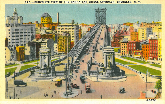
Birds-Eye View of the Manhattan Bridge Approach | Manhattan Post Card Publishing Company, B26-48701 | Online Collection of Brooklyn Museum
Though not as commanding as the triumphal arched, colonnaded set piece Carrère and Hastings designed for the Manhattan side, their Brooklyn pylons provided the borough’s newest gateway with some serious Beaux-Arts monumentality. At least that’s how it looks in the postcards. Robert Moses demolished the pylons in 1961 during his epic construction of the Brooklyn Queens Expressway.
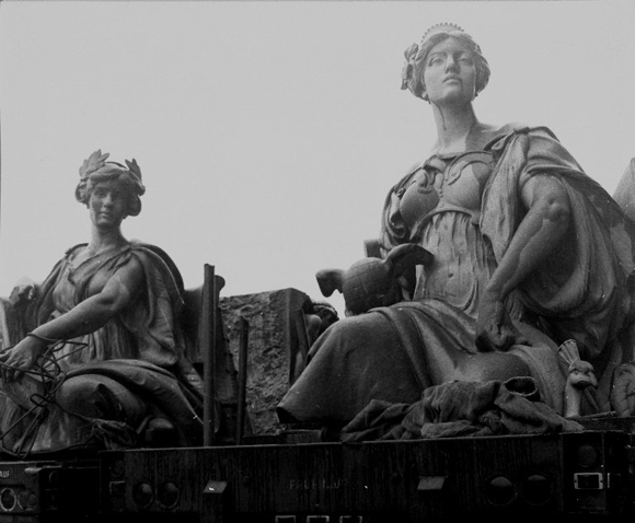
View of Daniel Chester French’s Brooklyn and Manhattan statues, on flatbed truck, 1964 | Online Collection of Brooklyn Museum
Among the piles of granite the Power Broker dismissed as “ornamental masonry” were 12-foot tall allegorical figures of Brooklyn and Manhattan sculpted by Daniel Chester French, who received $16,000 for the pair. It’s not hard to distinguish the boroughs: Manhattan is center-of-the-universe prideful, wearing a tiara, holding a winged globe, resting her foot on a treasure chest, and flanked by a peacock; Brooklyn is civic virtue embodied, a laurel wreath on her head, a church to her left, a young boy reading to her right. After the City Art Commission spared the pair, they moved further down Flatbush and onward to Eastern Parkway, finding a permanent home in front of the Brooklyn Museum.
In substituting highway exit for grand entrance, Moses treated Flatbush Avenue with the callous urban disregard that typified his later career. And since then, this part of the extension has had a hard time recapturing its “streetscape identity,” something the Department of City Planning recognized in its Downtown Brooklyn Pedestrian Study of 2010. Still, as Flatbush traversed the rest of the borough, there would be a few more opportunities for monuments of iconic architecture and infrastructure.
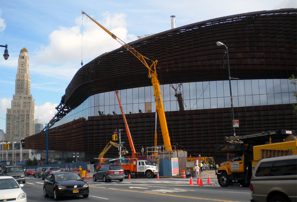
Barclays Center | Photo by Daniel Rojo
Notable, and most recent, in this regard is the Barclays Center, soon to be completed at the corner of Flatbush and Atlantic. Now, say what you will about Atlantic Yards as a whole, there is no denying that SHoP’s Corten steel snake will go a long way to relieving the sordid dullness of the Atlantic Terminal Mall, which has been sitting woefully at this major intersection (where the extension officially ends and Flatbush proper begins) since 2004. Best to move by quickly and set sights further down road where there’s reliable City Beautiful planning to anchor Grand Army Plaza, especially with John Hemingway Duncan’s triumphal Soldiers and Sailors Memorial Arch standing symbolically, if not literally, astride the avenue as the gateway to Prospect Park. The stretch through the park is as verdant as Flatbush ever gets, giving it, I suppose, a certain kind of grandeur.
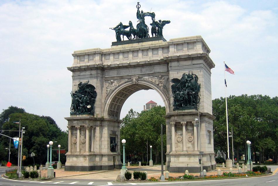
Soldiers and Sailors Memorial Arch | Photo by Wally Gobetz via Flickr
After that, though, it’s four and a half low-rise miles through the residential neighborhoods of Flatbush and Flatlands. At another major intersection, the so-called “junction” of Flatbush and Nostrand, there’s another mall, this one masquerading as a series of smaller buildings instead of a single big box, though I doubt anyone is fooled. The local BID is spearheading a beautification project that promises lots of new trees. This would be a welcome distraction, as will the completion of Brooklyn College’s newly-expanded performing arts center a short block to the west, intended as a new gateway to the campus. Beyond that, Flatbush crosses Avenues J through U on its way down to the edge of Jamaica Bay, its original southern termination.
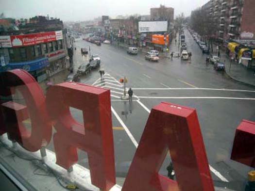
View of Avenue H, Flatbush Avenue and East 31st Street from the Target at Flatbush Junction, photo via Brownstoner
By the 1920s, plans were underway to extend Flatbush through the wetlands. When Floyd Bennett Field, the city’s first municipal airport, opened with great fanfare in 1931, Flatbush was nearly three miles longer. But the story doesn’t stop there, because Robert Moses had other plans. In the 1960s, on the opposite side of the borough at the opposite end of the avenue, Moses may have robbed Flatbush Avenue of its dignified commencement. But here, three decades earlier, he had given it a thrilling conclusion.
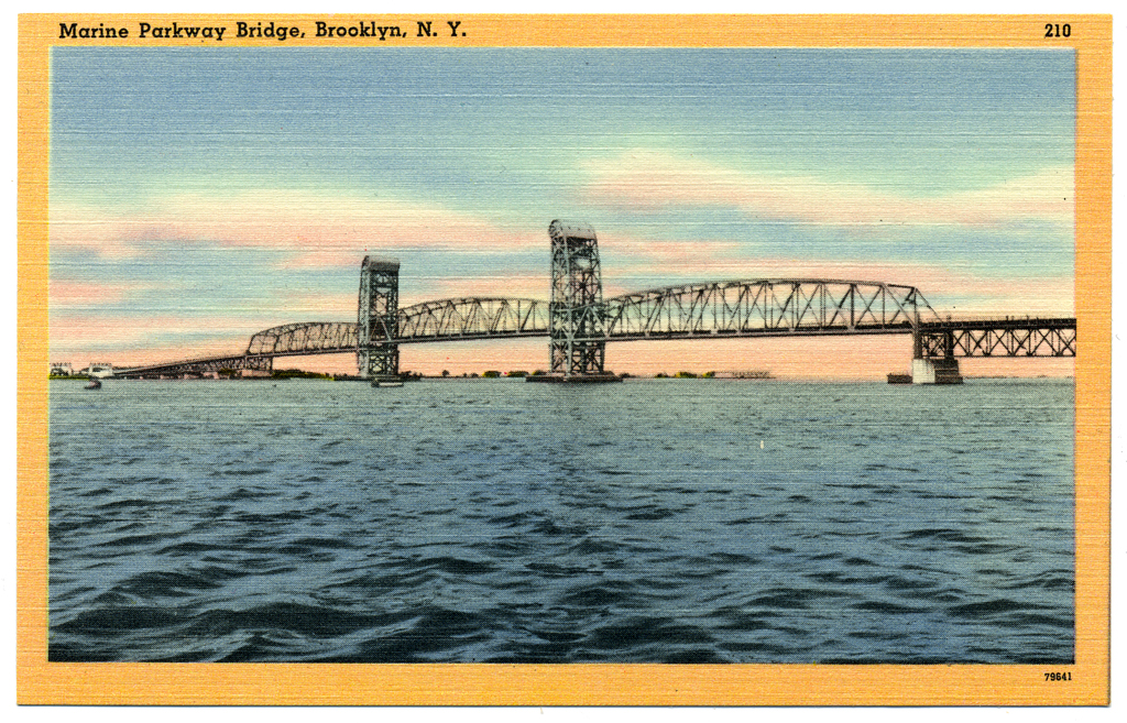
Marine Parkway Bridge | Acadia Card Company postcard, 210-79641 | Online Collection of Leiman Library
The Marine Parkway Bridge links southern Brooklyn to the Rockaways. The Times declared it a “motorway to seaside” when the bridge opened in 1937, which made sense since Moses built the bridge to provide car access to the beachfront recreation areas he had just completed at Jacob Riis Park.
Emil Praeger and the firm of Waddell & Hardesty engineered its vertical lift span, the longest in the world at the time. Aymur Embury, the Power Broker’s favorite architect — who supervised the design of the original McCarren Park Pool, Central Park Zoo and Orchard Beach Pavilion — designed the towers, terminating them with giant scroll-like forms that house the wheel mechanism in a sort of streamlined combo of classical volute and Chrysler hubcap.

Marine Parkway Bridge, tower detail | Photo by Flickr user animalvegetable
Approached at grade from Flatbush, the bridge really seems like a continuation of the avenue. Past the toll plazas it rises gently over the mudflats and salt marshes. Then, mid-span, above Jamaica Bay, an urban climax: look south beyond the peninsula and you see the Atlantic Ocean; look north beyond the flatlands and you see the skyline of lower Manhattan (Jersey City, too).
If you’re driving, it’s hard to appreciate the effect. Better to take to the bridge on foot or bike, which has economic as well as scenic advantages. This being a Moses project, the Marine Parkway Bridge was constructed by a public authority, and tolls have been charged from the beginning. Originally, the toll for motorists was 15 cents, and back then even the cyclists had to pay. Moses charged them a dime. Today, cars pay $3.25 in each direction, but bikes get to cross for free.
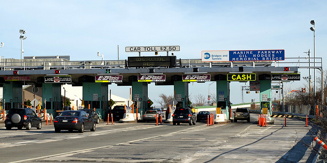

Above: Marine Parkway Bridge toll plaza | Below: View of New York City Skyline from Marine Parkway Bridge | photos by Gabrielle Esperdy
The views expressed here are those of the authors only and do not reflect the position of The Architectural League of New York.
Comments