
We are celebrating 15 years — and counting — of stories that are deeply researched and deeply felt, that build a historical record of what the city has been.
We are celebrating 15 years — and counting — of stories that are deeply researched and deeply felt, that build a historical record of what the city has been.
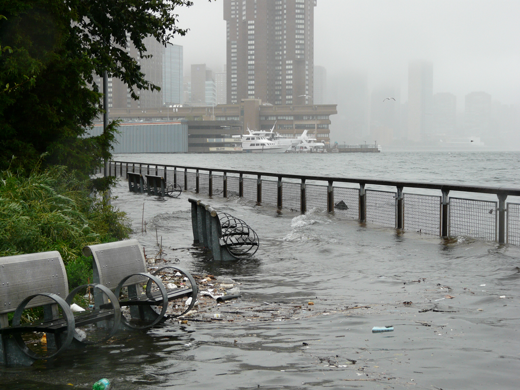
Stuyvesant Cove, August 2011 | Photo by Flickr user Marianne O’Leary
PLANNING TO BE FLOODED
The waterfront of New York City, in the glow of recent revitalization efforts, is often cast as home to lush new parks, shimmering new towers, and a burgeoning public transportation network with significant potential for expansion. But an article in The New York Times this week instead looks at New York’s 520-mile-long coastline as a site “lined largely by teeming roads and fragile infrastructure” that is “years away from — and billions of dollars short of — armoring itself” against rising ocean levels or storm surges. As the threat of flooding grows, some suggest that the City “lack[s] a sense of urgency” in its planning efforts and question its “resilience strategy,” which focuses on ensuring the city can withstand and recover from flooding through small interventions over time, rather than pursuing large-scale protections, such as surge-blocking sea gates. Klaus H. Jacob, of Columbia University’s Earth Institute, emphasizes the vulnerability of our infrastructure, explaining that a storm surge just one foot higher than last year’s Hurricane Irene — which had weakened to a tropical storm before hitting New York — would have been crippling: flooded streets, commuter rail “impassable or bereft of power,” certain subway tunnels “unusable for nearly a month, or longer” would have meant “an economic loss of about $55 billion.” The forecast is grim — and this is under an administration known for its interest in environmental sustainability. So why aren’t we better prepared? Much of it comes down to cost and complexity. Many strategies involve participation from the public and private sectors, from federal agencies to local community leaders. And ambitious prevention plans end up being scaled down when the funds simply don’t exist. Read the full article here.
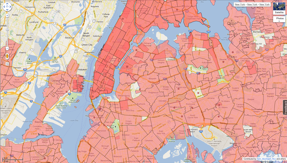
Screen grab of Google Map Maker’s map of New York City neighborhoods
DEEP MAPS
Search nyc.gov for an official map of the neighborhoods of the city and you will find something like this, a zoomed-out view of a broad swath of the city where names of neighborhoods hover, nonspecific, over the the well-defined edges of community board districts. Now try Google Map Maker, and see the results of a huge, endless user-generated effort to bring some definition to those ever-fuzzy boundaries. This week, articles in The New York Times and The Atlantic look at how advances in online cartography are influencing how the geography of the city is understood. The Times focuses on Google Map Maker, where last month users submitted more than 2,000 proposed revisions to a map of New York City neighborhoods, all of which were reviewed and then approved or denied by Google-designated “regional expert reviewers.” Not all areas are open to modification — “‘I’m not allowed to do something like delete the Lincoln Tunnel,'” one reviewer explains — but citizens can edit neighborhood boundaries and even create new ones. Not surprisingly, brokers and developers in New York change the maps frequently. According to the Times, a Brooklyn-based moderator recently “overruled a user who tried to relabel a swath of Brooklyn waterfront as ‘Rambo’ — for Right Around Manhattan Bridge Overpass.”
Alexis Madrigal of The Atlantic splices it a different way, giving a behind-the-scenes look at Google’s “Ground Truth” project. “Behind every Google Map,” Madrigal explains, “there is a much more complex map that’s the key to your queries but hidden from your view.” It’s a “deep map [that] contains the logic of places.” Ground Truth is an internal project, a more robust Map Maker, that allows humans (this time, Google employees, not the public at large) to “massage” Google’s astronomical amount of geographic data — and by doing so, create a far more accurate, efficient and usable map than pure data could ever provide. “We humans all hold a Borgesian map in our heads of the places we know and we use it to navigate and compute physical space,” Madrigal says. “Google’s strategy is to bring all our mental maps together and process them into accessible, useful forms.” The human manipulation of this computer-produced world is what makes it tick; human intelligence, not machinery, is building the virtual world just as much as the physical.
PERSERVERANCE PAYS OFF
Next month, nearly 40 years after Louis I. Kahn designed it, Four Freedoms Park will open on Roosevelt Island. Located on the southernmost tip of the island in the East River, the granite memorial to President Franklin D. Roosevelt’s famous 1941 “Four Freedoms” speech will be the only Kahn-designed structure in New York City. The design was finished just before Kahn’s death in 1974, and the project was shelved shortly thereafter for financial reasons. Though the park will not be open to the public until October 24th, Times architecture critic Michael Kimmelman got an early look at the space, and he seems to like what he sees: “It gives New York nothing less than a new spiritual heart. That’s to say it creates an exalted, austere public space, at once like the prow of a ship and a retreat for meditation. … It is as solemn as the Roosevelt wartime speech it honors, a call to safeguard the freedoms of speech and worship and the freedoms from want and fear.” Composed of a tree-lined triangular promenade culminating in a monumental open-air granite room, the memorial includes a bronze head of FDR, modeled in 1933 during Roosevelt’s first term, by American portrait sculptor Jo Davidson. Only minor changes were made to Kahn’s design by the team that executed the park (led by Mitchell/Giurgola Architects, with F. J. Sciame Construction Company, Weidlinger Associates and Langan Engineering), including (see above) a 15-inch lift of the entire site in response to rising water levels. Read Kimmelman’s review here and view the accompanying slideshow here.
EVENTS and TO DOs
DREDGEFEST
New York City’s current shorelines result from 400 years of intense human industry and exploration. Piers, infilling, and building construction have dramatically changed New York’s harbor and coastal ecology, but perhaps nothing more than the process of dredging. Dredging (the act of removing built up sediment from a waterway’s floor) is “perhaps the greatest unrecognized landscape architecture project in the world.” Or so say the organizers of Dredgefest New York City. A project by Columbia University’s GSAPP, Dredgefest — The Festival of Dredge! — will tackle the implications, effects, and potentials of the techniques, technologies and uses of dredging. A half-day symposium on September 28th will bring designers, scientists, professors and policy makers to discuss the city’s harbor and sediment systems. Then, on September 29th, a four-hour boat tour of the dredged landscape of New York Harbor will allow participants to see “dredge in action.” The event promises to be “a heady mixture of scientific knowledge, technical expertise, architectural theory, and heavy machinery.” The Dredge Research Collaborative, along with US Army Corps of Engineers, and the National Park Service will narrate the harbor tour. For more information or to purchase tickets, click here.
VIRTUALLY IMMERSED IN TOXIC WATERS
Newtown Creek, located between Brooklyn and Queens, is a Superfund site and “one of the most polluted bodies of water in the United States.” (Regular Omnibus readers may recall our fascination with the waterway, stemming from our early interview and meet-up with George Trakas, the artist behind the Newtown Creek Nature Walk.) This month marks the launch of a new artistic investigation into these murky waters. The Newtown Creek Armada is an interactive installation dreamt up by artists Sarah Nelson Wright, Nathan Kensinger and Laura Chipley, in collaboration with the North Brooklyn Public Art Coalition. Every weekend this month (September 15, 22, 29 and 30, from 1-4pm), visitors can “pilot a fleet of artist-made, miniature, remote-controlled boats along the surface of the Newtown Creek while documenting the hidden world of its waters using waterproof cameras and microphones.” Each unique visitor-driven voyage will be recorded by the underwater cameras fastened to the boats, creating an unusual archive of a month in the life of the Creek. Meanwhile, “video portholes at the project site give visitors a chance to virtually immerse themselves in the toxic waters.” Get a glimpse of the murky waters in the preview above.
A FIRST GLIMPSE OF A FUTURE UNDERGROUND
James Ramsey and Dan Barasch’s idea for the Lowline, an underground park on the Lower East Side, has received a lot of attention over the past year. The proposal, which so far has been limited to renderings and the imagination, is taking one step closer to becoming a physical reality. In a small exhibit titled Imagining the Lowline: A First Glimpse of a Future Underground (funded through an extremely successful Kickstarter campaign and by Audi of America), Ramsey and Barasch have installed a prototype of the “remote skylight” that makes the idea of an underground green space possible. The crucial technology, capable of transporting and concentrating natural sunlight through “advanced optical systems,” is made of over “600 laser-cut hexagonal and triangular anodized aluminum panels.” Imagining the Lowline will be on view from September 15-27 at the Essex Street Warehouse. Read more coverage of the installation at Architizer, Co.Exist, The Architect’s Newspaper, Transportation Nation, and The Atlantic Cities.
The Roundup keeps you up to date with topics we’ve featured and other things we think are worth knowing about.
The views expressed here are those of the authors only and do not reflect the position of The Architectural League of New York.