
We are celebrating 15 years — and counting — of stories that are deeply researched and deeply felt, that build a historical record of what the city has been.
We are celebrating 15 years — and counting — of stories that are deeply researched and deeply felt, that build a historical record of what the city has been.
On a chilly, overcast Saturday in late September, I boarded the S.S. American Princess at Manhattan’s Pier 11 for a boat tour of New York Harbor. This wasn’t your average scenic cruise however: I was one of more than 125 people spending a Saturday attending day two of DredgeFest, an event exploring “the human acceleration of sediments.” Put simply, dredging is the scooping up and removing of mud, silt, sand, clay, and other sediments from the beds of waterways. Its invisible processes belie its transformative impact on the physical shape of the city; dredging plays an enormous role in a complex network of geologic, economic, ecological and architectural forces, at local, regional and global scales. It is a crucial component of erosion control and habitat restoration, of toxic landscape remediation, of the establishment and preparation of global shipping routes, even of the New York City coastal real estate market.
To better understand this centuries-old practice of urban environmental manipulation, journalist Tim Maly helped to found the Dredge Research Collaborative, the group that organized DredgeFest. Here, he takes us on a tour of New York City’s dredged landscapes, from Battery Park City to Jamaica Bay, and explains how the city’s past, present, and future are shaped by technologies and applications of what the Dredge Research Collaborative call “the greatest unrecognized landscape architecture project in the world. – V.S.
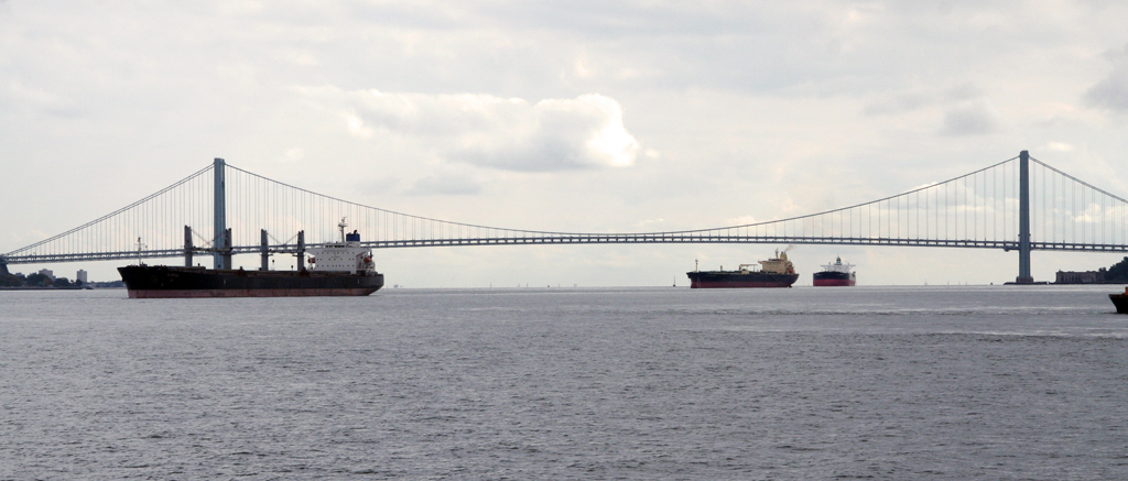
Let’s begin here, under the Verrazano-Narrows Bridge, at the notional border between New York City’s Upper and Lower Bays. The bridge is an architectural marvel. Its stately towers are visible from all five boroughs. Its span, once the longest in the world, remains the longest in the Americas. Thousands of ships pass beneath the bridge every year.
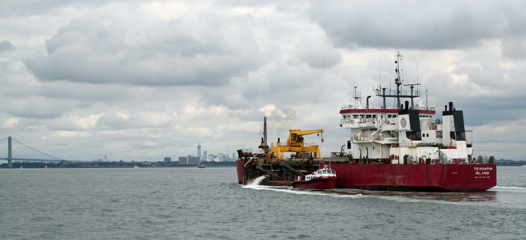
We’re looking for a relatively small ship, a vessel called the Terrapin Island, which is passing by on a course for the Lower Bay. The Terrapin Island, with its bright red hull and industrially hard-edged white superstructure, looks like its could be a ferry or a fishing trawler, except that a long chunk has been cut from both sides of the hull, almost down to the water line. In that gap is a tangle of black hoses and pipes.
The Terrapin Island is a hopper dredge. When it’s dredging, all those hoses are slung over the side, sucking sand and silt off the bottom of the estuary. Right now, it’s performing the second half of its function. Guided by satellites, the Terrapin Island navigates out past Sandy Hook and the Rockaways. With pinpoint precision, it finds its spot. The bottom of its hold opens, and 6,400 cubic yards of disposed material drops to the ocean floor.
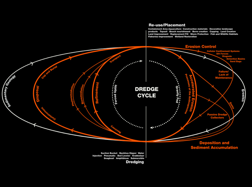
On the periphery of the city, at the littoral edge between water and land, a type of landscape architecture is reshaping New York at a monumental scale. It is difficult to see. It happens away from most people, far from the eyes of architects. Most of it happens underwater. It’s the landscaping that occurs when we mechanically lift and remove sand and sediment from one place and dump it somewhere else, an act best known as dredging.
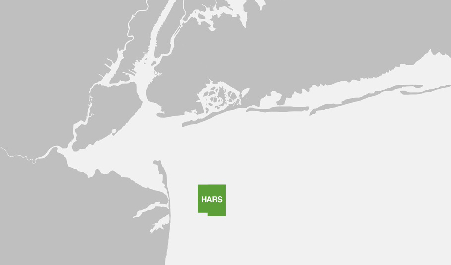
The Terrapin Island’s destination is called the Historic Area Remediation Site (HARS). It’s an underwater dumping ground. Before it was the HARS, it was the Mud Dump Site, once the destination of some of the most toxic chemicals on earth, mostly dredged from the NY/NJ harbor. We can’t remove the noxious stuff, so the US Army Corps of Engineers is overseeing a project to cover it over with (amongst other things) the relatively clean byproduct of another Army Corps dredging operation, the Channel Deepening Project. The Channel Deepening Project is the most recent example of a centuries-old dredging tradition in New York’s harbor.
Furnished with a vast protected but shallow estuary, New Yorkers have long been using the machinery of dredge—buckets, grabbers, suction, cutters, pneumatics, barges, hoppers, and backhoes—to dig, suck, plow, and cut. We’ve been carving channels and filling in shallows to suit our needs ever since this place was called New Amsterdam.
These days, much of that work is undertaken or at least overseen by the US Army Corps of Engineers. As the guardians and caretakers of the nation’s waterways, the shaping of New York’s increasingly artificial estuary falls under their purview. In order to make the scale of their work intelligible to the layperson, they speak in terms of football stadiums, Empire State Buildings and Everests.
You can’t see these projects from the shore, but strip away the waves and the scale becomes clear. The HARS site is an undersea delta, a massive finger of landscape roughly the size of Coney Island poking out into the Atlantic Ocean. The area has been the receptacle of unwanted soil, silt, and toxic waste since 1800. Every year, the Harbor Deepening Project has pulled three Empire State Buildings worth of dredged material from the bottom of the estuary and dumped it on the HARS. This has been going on for ten years.
It’s not much of a stretch to suggest that the Army Corps of Engineers are the most prolific landscape architects in the world. They are not working in isolation. They are part of a much larger tradition. New York’s dredged landscapes are shaped by a sprawling network of causes. But the reasons behind these projects extend beyond local or regional ecologies. Dredging represents a mixture of accidents of history, policy, and design decisions that reverberate around the globe.
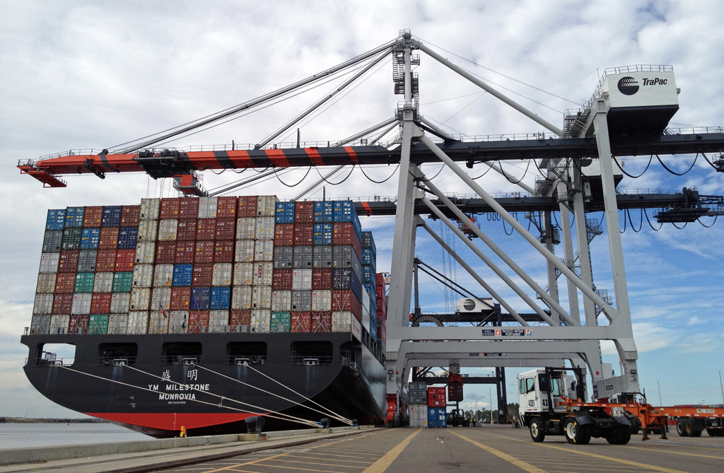
To understand why all this silt is being moved, we must go thousands of miles west to Shanghai, where a container ship is being loaded with goods bound for NYC. Our anonymous ship is one of thousands that will enter the NY/NJ Harbor this year and represents a fraction of the more than a hundred billion dollars in trade that sustains New York and New Jersey’s economies. Without knowing much about it, we can name its exact size. It’s no more than 965 feet long, 106 feet wide, and it draws no more than 39.5 feet below the waterline.
We can be more sophisticated about our units of measurement. The shipping industry doesn’t think in feet, but in TEUs, which stands for Twenty-foot Equivalent Units. Cargo containers can come in a variety of sizes, but they are all abstracted to TEUs, a volume of shipping capacity roughly the size of a single 20-foot cargo container. Our anonymous ship is carrying 5,000 TEUs.
When fully loaded, the ship will present a comical figure, a thin hull top-heavy with stacks of brightly colored blocks. Even so, it’s far from the biggest ship in Shanghai. Some of its neighbors are carrying 14,000 TEUs or more, but they won’t be coming to New York.
Goods travelling from China to America’s East Coast have two choices. They can either make landfall somewhere like Long Beach or Oakland and then travel across the continent over land, which is expensive, or they can stay ocean-bound for as long as possible. The shortest route from Shanghai to New York passes through a choke point two thousand miles to the south, in the Panama Canal.
The Panama Canal was built nearly a century ago. Its once ample locks have been outstripped by decades of advancement in marine engineering, which can now produce leviathans, and by decades of advancement in global supply chains, which can now make use of leviathans. Today, there are two classes of container ships in the world: Panamax, which can fit through the Panama Canal, and Post-Panamax, which cannot.
Much has been written about the far-reaching effects of globalization, and we needn’t revisit that literature here, except to point out that in the totalizing vision of logistical analysis, a terrorist attack and a customs delay are essentially the same thing: a disruption in the flow of goods. To be faced with one small leg of a trans-oceanic journey that requires inefficiently small vessels is nearly insupportable. In 2007, work on the Panama Canal widening project began. When complete, the “New Panamax” capacity will jump from 5,000 TEUs to 12,000 TEUs. Those ships will be looking to make landfall somewhere on the Eastern Seaboard, and so the decision to widen the canal has set off a design shockwave that is transforming the landscapes of cities from Miami to New York, each one racing to dredge channels at least 50 feet deep to accommodate the new vessels.
This race is not friendly. It is not clear that all of the cities racing to dig out new passageways for these boats will ever see them used. Container ships don’t like to stop; it costs valuable time. Larger vessels will be looking to make landfall in fewer places, leaving some cities with shiny facilities and nothing to berth.
This dynamic is one that Manhattan Island knows all too well. It was once the heart of New York’s harbor. Today, the Channel Deepening Project won’t go anywhere near it. Instead, it takes a sharp westerly turn just past Staten Island and cuts to the Port Newark-Elizabeth Marine Terminal and Global Marine Terminal, both in New Jersey, along with the New York Container Terminal in Staten Island. (There are plans for a channel to the South Brooklyn Marine Terminal and Red Hook, but they have been deferred. This does not bode well for the future of shipping to those places.)
Port Newark-Elizabeth is the result of a massive cut-and-fill landscaping project that transformed littoral wetlands into a series of right-angled sharp divisions between sea and shore. Two long rectangular channels define three fields of tarmac, all covered in a carnival of brightly colored containers and equipment. Towering orange cranes lift the containers on and off their ships, and a strange bestiary of specialized machines shuttles them to their destination in the stacks, where they await transfer to truck or train.
The lines of trucks that proceed through the terminal are driving on land that once lay in the channels that now house the ships. It was dredged up and remediated, the result of another global design shockwave that began in 1956. But where the Channel Deepening Project is a response to conditions somewhere else, Port Newark-Elizabeth was an epicenter.
The world’s first container ship, the SS Ideal X, made its maiden voyage from the Port of Newark in 1956 (it carried around 95 TEU). In 1962, the newly dredged Elizabeth Channel saw the opening of the Sea-Land Container Terminal, the world’s first port facility dedicated to moving containers. It was the prototype for everything that was to come.
Traditional shipping had involved either bulk material like grains, which could be poured into a vessel, or break bulk, which meant any other kind of cargo. Break bulk cargo could be anything from barrels of corn syrup to crates of electronics. All that cargo came in different shapes and sizes. All of it had to be loaded and packed by hand. Container shipping changed that. The containers were packed and unpacked at the source and destination. The ship simply had to load them on and off, in a standardized and repeatable pattern. The savings in time and labor were enormous.
Port Newark-Elizabeth sucked the life out of the ports of Manhattan and Brooklyn. In those antiquated facilities, dockworkers struggled to keep up with demand, larger ships had trouble mooring, and departing trucks had to navigate downtown traffic. Meanwhile across the harbor, trucks rolled off the New Jersey Turnpike, unloaded, loaded and rolled back on to one of America’s great arterial roads. There was no contest.
In desperation, New York City proposed a series of increasingly radical construction projects to revitalize its dilapidated piers, to no avail. Shipping in Manhattan collapsed completely, and with it the communities of dockworkers and their families who once lived on the shore. This, in turn, coincided with the collapse of the factories and warehouses that had been built to take advantage of the nearby shipping facilities. The scars of that collapse can be seen to this day in the abandoned factories and lofts that now house chic restaurants and media start-ups. The High Line is an architectural marvel made possible by the dredging of Newark Bay.
Lying on the southeast edge of Manhattan, Battery Park City covers over another set of Newark Bay-related scars. It is all infill, built on the remains of piers abandoned as Port Newark-Elizabeth waxed and Manhattan waned. The land itself comes from the excavation of the World Trade Center and from sand dredged off of Staten Island. Today’s Manhattan is a much wider and flatter island than the one settled by the Dutch in 1614. Over and over again, as Manhattan has become intolerably crowded, developers have sought to ease the pain by building outwards.
In 1660, Pearl Street ran along the shore. Captain Kidd had a waterfront property at the corner of Pearl and Wall. Today, that site lies three blocks inland. In the 1690s, the City sold water lots to private would-be landowners, each forty feet wide. Purchasers agreed to infill forty feet into the river, leaving space for public access wharves on the far side. These wharves became Water Street, which is itself two blocks away from the shore today, thanks to subsequent infill.
When these areas were built up, landscapers didn’t build very high. As sea levels rise and the climate becomes increasingly wild, we now have a series of artificial flood plains populated by people who did not sign up to be residents of a flood plain.
You can roughly trace Manhattan and Brooklyn’s original shorelines by looking at a map of the flood zones. Take away Zone A, and you get a pretty good picture of the ancient boundary between water and land. Some of that territory didn’t use to be land at all. Much of it was marsh and wetland.
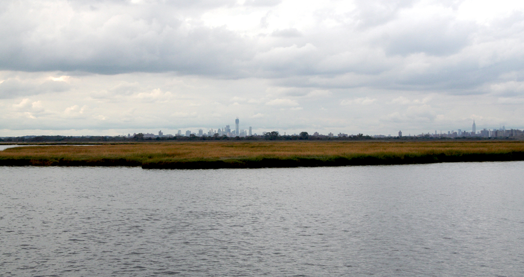
If we leave Manhattan, passing back under the Verrazano-Narrows Bridge before proceeding east around the tip of Coney Island to the north of the Rockaways, we arrive at the Jamaica Bay Wildlife Refuge.
Jamaica Bay was once a vast network of shallow marshy islands ringed by wetlands. Most of the wetlands have been infilled and hardened into neighborhoods in Brooklyn and Queens. What’s left of the islands remains a habitat for a dizzying array of fish and fowl.
Today, the islands of Jamaica Bay are washing away. No one knows exactly why, though it’s reasonable to suspect that the deepened channels with their stronger currents are playing a role. In 2003, the Bay was losing 40 acres a year. In an effort to reverse the loss of habitat, the National Parks Service finds itself in the profoundly uncomfortable position of being creators, rather than preservers of landscape.
Since 2006, contractors led by the US Army Corps of Engineers have been using sand dredged from the Upper Bay during the Channel Deepening Project (just under an Empire State Building’s worth) to create new marshland. When they are done, they expect to have 155 acres of new island.
What’s remarkable about these landscapes is how thin they are. Viewed from a boat, they are flat ribbons of grey, barely distinct from the horizon, but for the tufts of grass and flocks of birds who make their home there. The new islands blend nicely into the old, though the patterns of tufts appear a little more regular than one might expect to find in nature.
But placing sand in island shapes is not enough. Because the islands are appearing in the blink of an eye, ecologically speaking, they are at risk of incredibly rapid erosion. Natural islands develop a healthy covering of plant life over the course of their accumulation, which serves as an anchor. New plants are not strong enough to provide the same utility, and so, created islands demand millions of transition plants, grown in nurseries, to pre-age the island. Once planted, their sturdier roots help the islands hold together long enough for a full ecosystem to boot up.
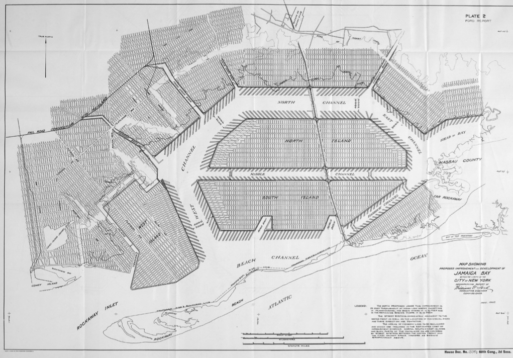
Jamaica Bay could have been a port. The 1907 Report of the Jamaica Bay Improvement Commission proposed to reconfigure the bay into two massive islands ringed by piers. The endeavor would have involved moving 267 million cubic yards of dredge (190 Empire State Buildings) in a cut-and-fill operation similar to what would later occur at Port Newark-Elizabeth.
Though some dredging did occur, by the 1920s New York’s aspirations had moved to the air. Plans for the port were scrapped while work began on the construction of Floyd Bennett Field, which lies on the west end of the Bay. New York’s first airport was built on what had once been 33 islands interconnected by marshland, filled in with six million cubic yards (four Empire State Buildings) of sand dredged out of Jamaica Bay. In 1942, the City began filling the marshy land around the Idlewild golf course, which lay on the east end of the Bay. In time, that too became an airport: John F Kennedy International.
Local wildlife has been slow to adapt to this new reality. Occasionally, runways have to be closed down due to Diamondback Terrapin turtle egg-laying migrations. Of the many benefits to maintaining habitat in the Wildlife Refuge’s ecology, perhaps the strangest is the increased safety it offers air travellers. When the islands are kept attractively open, migratory birds are diverted away from the airport, reducing the number of flight-ending bird strikes.
Perhaps even stranger is the possibility that the enlarged islands could have a calming effect on storms. In order to cause floods, a storm needs water to work with. By reducing the total volume of water available in Jamaica Bay, these new islands could reduce the maximum height of a storm surge in the surrounding area.
It is a small miracle that Jamaica Bay’s habitat can be safely replenished with sand from the NY/NJ harbor. There is a centuries-long legacy of industrial-scale dumping in New York’s waterways.
On the beaches of Floyd Bennett Field, from time to time chunks of horse bone will wash ashore, a legacy of Barren Island, one of the 33 that were filled in to create the airport. From the 1850s to the 1920s, while Manhattan ran on horse power, dead animals were brought here to be processed. Dozens of rendering plants lined what is still known as Dead Horse Bay, and Barren Island got its name because not much of anything could live there.
To the north, a 200-mile stretch of the Hudson running from the Battery to Hudson Falls is home to one of the largest of the EPA’s Superfund sites, where 1.3 million pounds of PCBs were dumped by General Electric. Under EPA supervision, about two Empire State Buildings worth of contaminated riverbed will be dredged up, de-watered, and sealed away.
Not all contaminated soil can be safely removed. Some of it must remain where it is, as with the HARS site. Instead of cleaning, all that’s left to be done is covering.
So we return to the slow landscaping of the Terrapin Island, as it cruises along with 0.005 of an Empire State Building in its hold. As we watch it reach its destination and dump its cargo, we can see now that it is doing double duty, both carving and covering.
The Terrapin Island turns, and begins cruising back to the Upper Bay. Behind it is the underwater monument to past negligence that is the HARS. Ahead, the monument to future logistics that is the Channel Deepening Project. To the west lies Port Newark-Elizabeth and the triumph of industrial efficiency. To the east, Jamaica Bay and the possibilities of soft infrastructure. In the distance lies the city.
All of these things, built on dredge.
The views expressed here are those of the authors only and do not reflect the position of The Architectural League of New York.
Comments