
We are celebrating 15 years — and counting — of stories that are deeply researched and deeply felt, that build a historical record of what the city has been.
We are celebrating 15 years — and counting — of stories that are deeply researched and deeply felt, that build a historical record of what the city has been.
To mark the fifth anniversary of the launch of Urban Omnibus, we look at themes that have emerged in our content over time and think about what those threads reveal about the needs, desires, and priorities of the city today.
Urban Omnibus was conceived primarily as a space to highlight ideas with the potential to create smarter, fairer, and greener cities of the future. While most of our time is spent on such forward-looking work, we also know that an understanding of cities’ pasts can be integral to the implementation of such new ideas in the complex present. With that in mind, we occasionally look to New York City’s history — captured by its buildings, neighborhoods, unrealized visions, and dreams fulfilled only to be lost to time — for instruction.
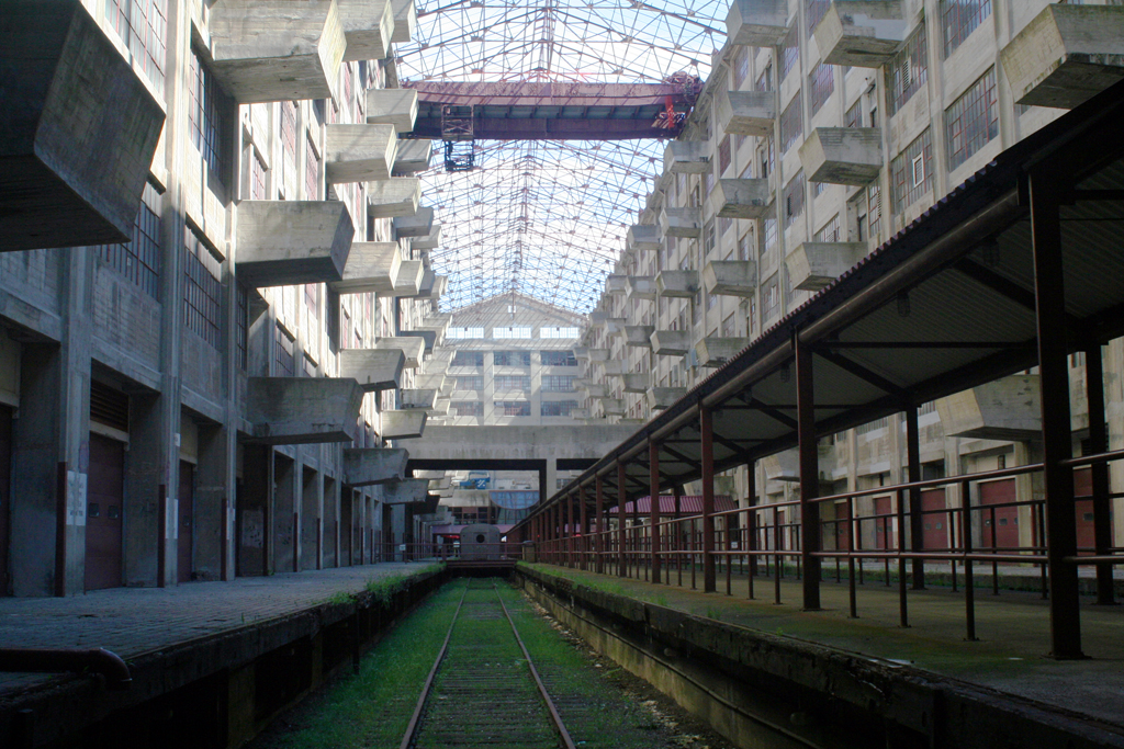
Brooklyn Army Terminal, 2011 | Photo by Varick Shute
The architecture of the city is embedded with history; the style, program, site, scale, and material of a building all reveal hints about the particular time and historical forces that brought about its construction and subsequent preservation, decline, or reuse. In Pelham Bay Park in the Bronx, the Orchard Beach Pavilion — a landmark of public architecture of the New Deal-era Works Progress Administration and the commitment to public recreation that marked Robert Moses’ tumultuous tenure as the City’s (unofficial) master builder — languishes neglected, according to Deborah Wye, a curator whose interest in the building’s history turned into passionate advocacy for its restoration. National Guard armories, some still active, are curiously integrated into the neighborhoods of the city, offering a reminder of the Guard’s history as a civic institution entwined with local life, as a force to combat urban unrest, and as a vital source of disaster relief across the states. The Brooklyn Army Terminal in Sunset Park, another locale of military life in the city, and its recent transformation into a light industrial center speak to the waves of change that have shaped the city’s working waterfront. And on a smaller scale, the often-overlooked wooden-framed houses of Brooklyn recall and preserve an architectural style made obsolete due to fire concerns.
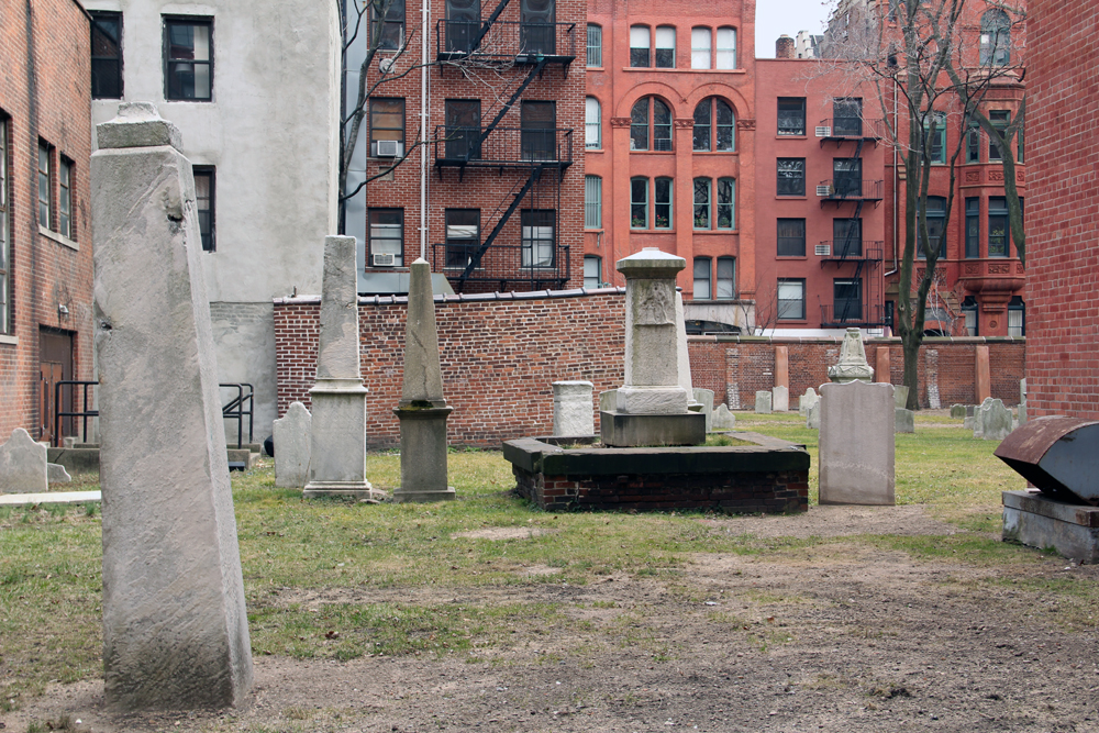
The Mulberry Street cemetery at Saint Patrick’s Old Cathedral | Photo by Cassim Shepard
The history of Saint Patrick’s Old Cathedral in SoHo, which first opened its doors in 1815, reflects a broader story of development across Manhattan. The Cathedral originally served as seat of the Archdiocese in New York City, but as the city expanded uptown, the seat moved to serve this growing population. The neighborhood around Saint Patrick’s was also changing, and along with the shifting identity of SoHo, the Cathedral has continually adapted to fulfill new roles in its immediate community. The historic legacy of Gravesend, Brooklyn, reaches even farther back in time to the settlement of North America by European colonists. The neighborhood, settled while the area was still under Dutch rule in 1645 by a wealthy British widow in search of religious tolerance, retains its original quadrants, cemeteries, and some original buildings; such living pieces of history beg to be explored.
While such physical manifestations of times past may be their most accessible markers, what came to be is but one facet of the past. Exploration of that which never was — ideas, speculations, and fantastical visions — is the aim of the Museum of the Phantom City, an app that allows the exploration of the urban environment by recalling those ghosts. One such proposal that never came to fruition is Modernist architect Paul Rudolph’s plan for a Lower Manhattan Expressway — a grand highway connecting the Holland Tunnel to the Williamsburg Bridge via Broome Street. The plan reflects what was, during its formulation from 1967 to 1972, the waning lure of high-speed highways, slum clearance, and high-rise housing intended to bring order to the city. Next time you are waiting for a late friend or a late bus, take a small adventure with the app and find what you never knew almost existed.
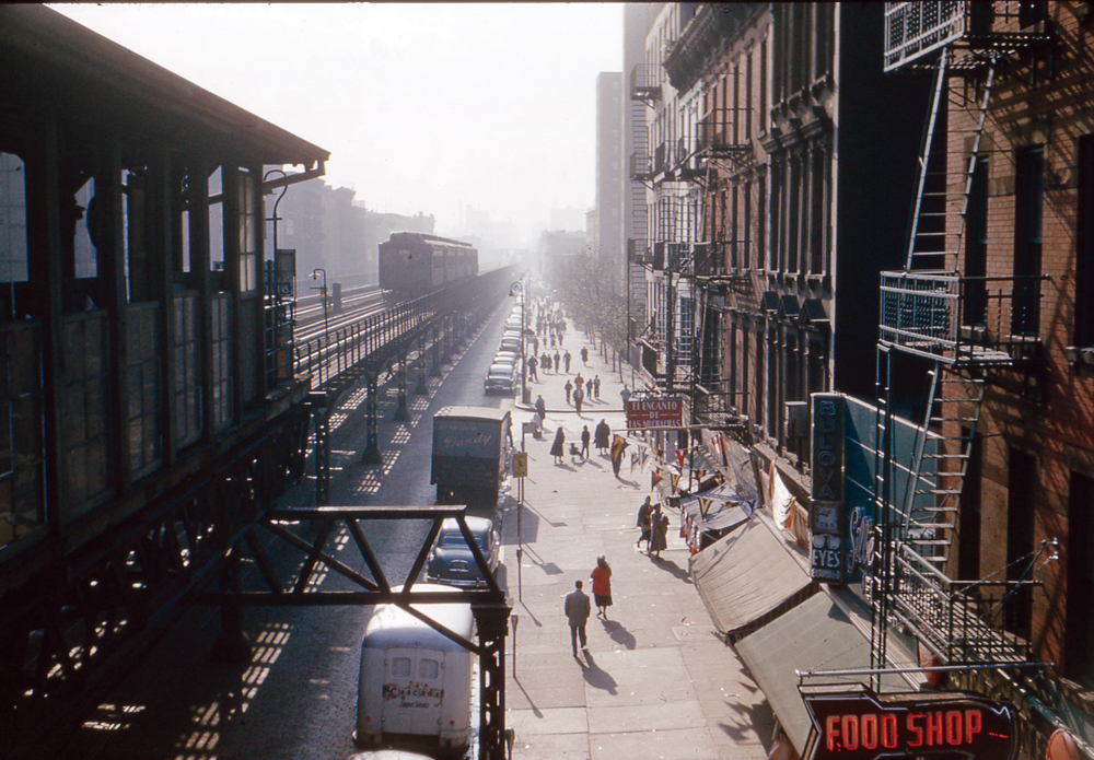
A downtown train passing 115th Street | Photograph by Lother Stelter from the book By the El by Lawrence Stelter
Visual documents may help us resurface imagined futures that were unfulfilled, but they also help us remember what the city has lost. Lothar Stelter, an installer for the New York Telephone Company, made it his hobby to photograph the Third Avenue elevated train between 1951 and 1955. His photographs recall rapid transit options that predated the subway, the development patterns that followed the Els, craftsmanship that’s all but lost, and how the current administrative and ownership structure of the city’s public transportation arose. Photographer Christopher Payne’s interests in purpose-built spaces that have fallen out of use led him to document the substations that used to power the City’s subway system, state mental hospitals that have fallen into disrepair, and an abandoned hospital on North Brother Island in the East River. And the Triangle Fire Open Museum memorializes one of the city’s great tragedies, an event with outsize influence on contemporary safety requirements and workers’ legal protections. By installing objects and photographs from its Open Archive throughout the city, it weaves this history into our daily lives.
History is also often, very literally, written. Such is the case with legal structures that guide what the built environment looks like and how we interact within it. The creation and evolution of the American municipal traffic code over the past century acts as a lens to view the different actors involved in shaping how we view and use streets today. In line with banking laws encouraging branches to serve all communities, not just those of means, Chemical Bank, a legacy institution of J.P. Morgan Chase, emphasized its role as a neighborhood institution that tailored its services to fulfill local needs in all the neighborhoods of New York. Their advertisements promoting this commitment give us a particularly interesting, subjective historical portrait of the bygone role of the neighborhood bank. In these records, we are able to consider how the city has changed in response to the innumerable forces shaping its development, and to consider what a better future could look like.
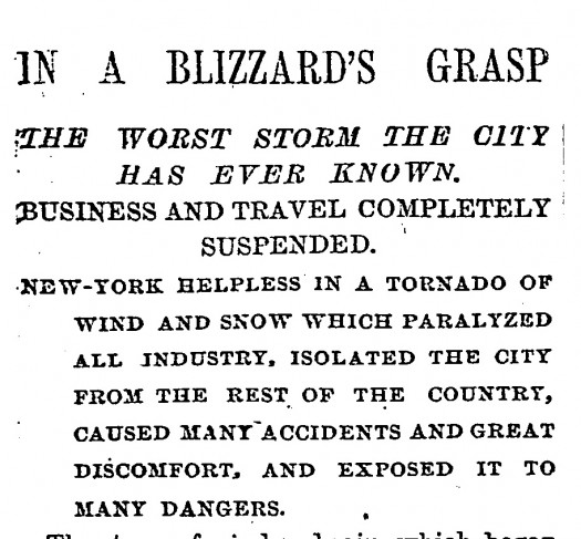
New York Times headline on March 13th, 1888, following “The Great White Hurricane” that dumped over forty inches of snow in the city and led to a new law prohibiting overhead lines transmitting electricity to trams, trolleys, and buses. The storm and the law is attributed by some with pushing forward development of subways in major northeastern cities, and it remains in effect, constraining the city’s transit possibilities. | Click the image to read more about “The Blizzard of 1888 – and what it means for mass transit.”
The views expressed here are those of the authors only and do not reflect the position of The Architectural League of New York.