
We are celebrating 15 years — and counting — of stories that are deeply researched and deeply felt, that build a historical record of what the city has been.
We are celebrating 15 years — and counting — of stories that are deeply researched and deeply felt, that build a historical record of what the city has been.
To mark the fifth anniversary of the launch of Urban Omnibus, we look at themes that have emerged in our content over time and think about what those threads reveal about the needs, desires, and priorities of the city today.
In getting to know a place, we often rely primarily on personal experience — a weekend stroll that expands our mental geography of the city or gradual internalization of subway etiquette. But as we create this individual perception, we also take in an array of representations of the city: diagrams that seek to simplify its complex systems, maps to locate things physically, photography that focuses our attention on something that may otherwise go unnoticed, or a documentary film that imparts another’s narrative of experience. These representations can enhance our understanding of personal experience or spur new ways of interacting with the places around us.
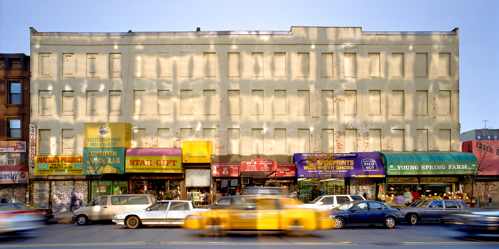
© Albert Vecerka/Esto
In an era in which people often carry tiny cameras around in their pockets and sharing photos in real time is a social media phenomenon unto itself, photographic representation of the city seems ubiquitous. With each comes a particular frame on place deemed worthy of attention. Stanley Greenberg‘s photography exposes unseen places and how things work, including water systems, architecture under construction, physics labs, telescopes, and dams. Albert Vecerka, in photographs documenting Harlem over the past 15 years, initially sought to show his neighborhood in its best light. As the neighborhood underwent dramatic shifts and he continued to shoot, he focused on recording these changes in the physical environment: “The photographs allow you to perform an almost forensic examination of what was here, and what’s visible now. Then, when it starts to disappear, you can see what replaces it, and whether that replacement is better or not.”
Using the production of short films as a means to investigate the neighborhoods of New York was the basis of Montage City, a workshop for architecture, urban design, and urban planning students taught by UO Editor Cassim Shepard. Not only does this representation present an opportunity to understand a place, it also proves “uniquely suited to the study of urbanism, particularly for designers learning how to propose sensitive and sophisticated interventions in the landscape.” Archipelago, an original Urban Omnibus video production, shares the same assumption. Produced for The Architectural League’s exhibit New New York 2001-2010: The City We Imagined / The City We Made, the short documentary explores how the physical city shapes how we live, work, play, and move through a day in the life of five New York neighborhoods: Hunts Point, Jamaica, Mariner’s Harbor, Downtown Brooklyn, and Chelsea.
Drawing — whether by hand or digitally — is at the core of both architectural and more purely artistic representation. In 2012, The Architectural League in partnership with the New York Transit Museum hosted a competition for sketches and drawings that captured or re-imagined Grand Central Terminal on the eve of its centennial in 2013. The winners capture the many ways architects and designers can experience and represent a common place. And just as serial images are used to craft narrative in film, drawing and illustration serve the same purpose in graphic novels by Ben Katchor and Chris Ware. Each takes human experience of the built environment as a key frame of their overall works but utilizes very distinct styles and organization to express, respectively, the annoyances and ridiculous aspects of urban life and the lives — contemporary, past, and future — bound together by one Chicago walk-up.

For a studio at NYU’s Gallatin School, Kaitlyn Curran mapped discrepancies between community board boundaries and apartment listings advertised on Craigslist to demonstrate the ways real estate interests manipulate neighborhood borders.
Mapping seems just as ancient and innate an aspect of human culture as its precursor, drawing, and as ubiquitous as photographs are today. And while traditional cartography showing direction and spatial relationships retain their importance, the expanded realm of mapping that layers and combines many types of information allows us to better understand intersecting complex systems and relationships. Louise Harpman took this potential as the means and subject of investigation for her course at NYU’s Gallatin School, in the process teaching design skills as well as key theoretical concepts in sustainability and urbanism. Critical reflection on urban cartography was the subject of a series of an earlier series on UO, featuring, among other pieces, a perspective on OASIS — an online, public map with valuable land use information for NYC — and a conversation with renowned information graphics artist Joe Lertola. The diversity of forms maps can take and what they can represent was on display at the exhibit You Are Here -> Mapping the Psychogeography of New York City in 2010: everything from smell preferences to anxiety were represented in materials as diverse as Jell-O and silver leaf. A variety of media — film, audio, photography, and drawing — also contributes to the project Mapping Main Street’s ability to effectively capture the diversity of Main Streets that dot the United States. With a wider variety of representative techniques at our disposal, the potential for enhancing and expressing such perceptions and analyses of place is greater than ever.
The views expressed here are those of the authors only and do not reflect the position of The Architectural League of New York.