
We are celebrating 15 years — and counting — of stories that are deeply researched and deeply felt, that build a historical record of what the city has been.
We are celebrating 15 years — and counting — of stories that are deeply researched and deeply felt, that build a historical record of what the city has been.
Superstorm Sandy brought the Rockaways into the forefront of New Yorkers’ consciousness for a period of time, first as the focal point for media coverage of recovery efforts, subsequently as a key reference point in debates about rebuilding versus retreating from the flood zone. But the questions about how best to develop this singular stretch of waterfront neighborhoods in Queens reach much further back than the recent, pre-storm “discovery” of the charms of its boardwalk or post-storm memories of the destruction’s extent. Arverne is just one of the Rockaways’ many neighborhoods, nestled toward the peninsula’s easternmost communities of Far Rockaway and Edgemere, eight miles from Breezy Point on its western edge. Here, arguments about sustainability, class, affordability, and the public role in housing development are manifest in four development sites within the Arverne Urban Renewal Area.
The last of these sites is Arverne East, 81 acres of City-owned land that have remained vacant since the neighborhood was razed in 1969. Below, Jonathan Tarleton and Gabriel Silberblatt consider Arverne East’s uncertain future. They report on a design competition that sought to envision resilient housing that would stitch together neighborhoods on either side of this long-fallow land. And they tease out threads of the distinct visions — from community members, housing advocates, architects, and developers — of how this public asset might best be put toward public purpose.
This post appears as part of a three-part Architectural League feature on the past, present, and future of Arverne. Visit archleague.org to learn more about Arverne’s history, to read about the past 15 years of development in the area, and to see material from the 2001 Architectural League exhibition, Arverne: Housing on the Edge. — C.S.
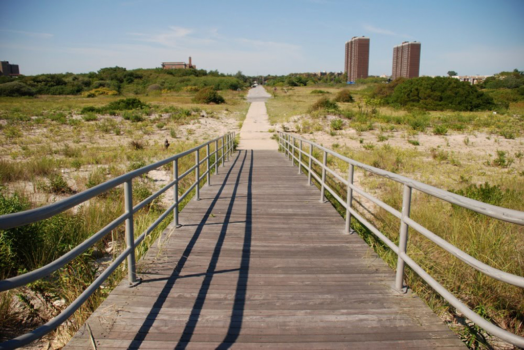
Arverne East from the boardwalk, 2010 | Photo by Nathan Kensinger
Riding out to the Rockaway peninsula in Queens, the A train inches its way across Jamaica Bay on a thin spit of land now bordered by a $38 million steel wall. The beaches and wetlands along the islet are speckled with a few boats left unclaimed after Sandy. As you reach the 11-mile barrier island separating the bay from the Atlantic, small houses sit precariously on top of a pier to the right. Curling to the left along the elevated tracks to Far Rockaway, a mix of bungalows, mid-rise buildings, and towers-in-the-park intermittently blot out the waves of the sea beyond. But soon the view is unimpeded. At Beach 56th Street, just past the bright, white-trimmed mass of condominiums known as Arverne-by-the-Sea and the irregular balconies of newly-renovated Arverne View, sits fallow land.
Called Arverne East, this 81-acre tangle of deteriorating street grid, scrubby plant growth, and detritus new and old extends west along the coast to Beach 32nd Street, pinned between the boardwalk and the elevated A line. In an increasingly built-out city, the rare existence of such an expanse of vacant land is striking. Contemporary Arverne East is the creation of urban renewal, a program that held sway from the 1950s through the ‘70s in which broad swaths of areas designated as slums were bulldozed to make way for new housing developments. But until quite recently, the 308 acres that made up the full Arverne Urban Renewal Area (AURA), cleared of its residents and the beach bungalows that housed them in 1969, remained undeveloped.
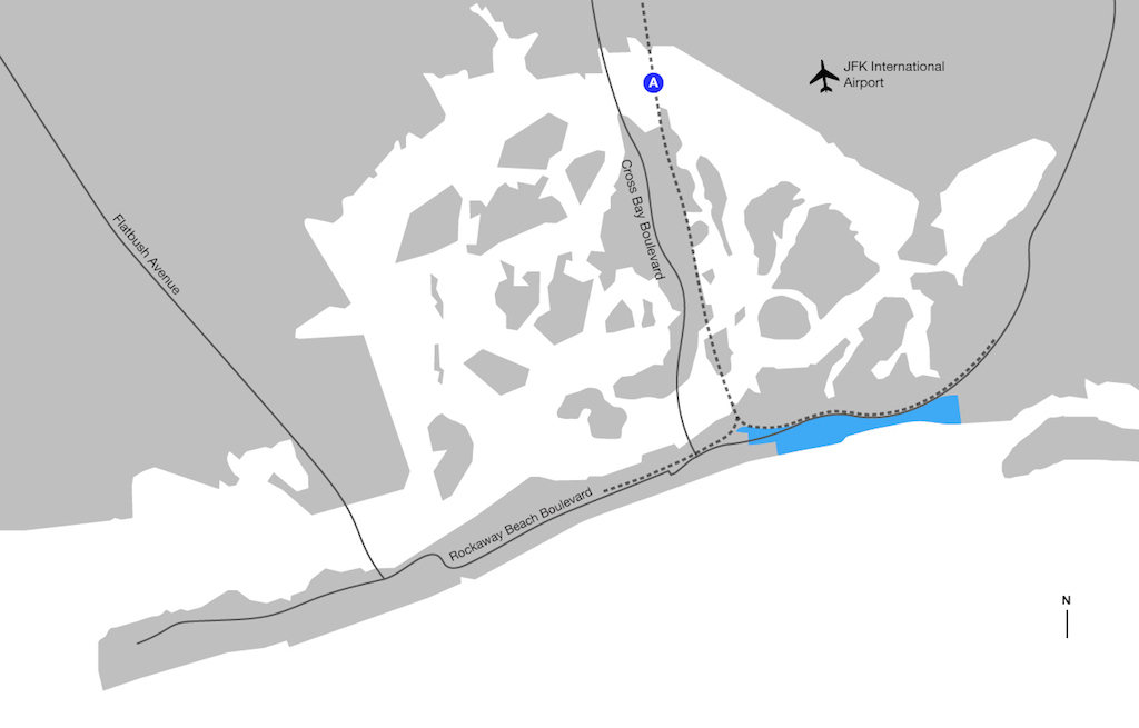
Arverne Urban Renewal Area | Map by Jonathan Tarleton
While Arverne East may look like an unkempt nature preserve, the AURA was never intended to serve as the home for the hawks, gulls, and endangered piping plovers that nestle in its trees and sandy soil. Following demolition, initial plans for the site called for 6,500 apartments and year-round regional and local recreation, but these were never carried out due to a collapsing real estate market. The long wait for construction in the AURA came to an end with Water’s Edge — a small infill condominium project whose first phase was completed in 2001 — and development in the AURA gained further steam in 2002, when a partnership between Benjamin Companies and the Beechwood Organization broke ground on Arverne-by-the-Sea, a 117-acre mixed-use development organized into six “communities.”

Developments in the Arverne Urban Renewal Area | Map by Jonathan Tarleton
The designation in 2006 of a partnership between L+M Development Partners, The Bluestone Organization, and Triangle Equities as developer for the remaining land of the AURA, Arverne East, seemed poised to deliver on the many unrealized promises of urban renewal that have beset the neighborhood since the 1960s. But according to Steve Bluestone, partner of The Bluestone Organization, the combined challenges of $100 million needed to rebuild the crumbling infrastructure on the site and another crashing housing market in 2008 scuttled the project.

The boardwalk bordering Arverne-by-the-Sea, 2014 | Photo by Jonathan Tarleton
A Moment of Opportunity
Four years later, in October 2012, Superstorm Sandy wrought havoc across the Rockaways: Breezy Point burned and the storm surge flooded the peninsula from both the sea to the south and the bay to the north. 33,000 residents would register with FEMA, 25% of whom had suffered property damage in excess of $20,000. The wake of one of the most devastating storms in a city’s history may not seem the ideal time to revive plans for development on one of its most vulnerable sites. But a group of organizations spanning the public, private, and nonprofit sectors — the team of developers along with Enterprise Community Partners, the American Institute of Architects (AIA) New York Chapter, and the City’s Department of Housing Preservation and Development (HPD) — quickly generated a design competition for Arverne East. The vulnerability of the site took center stage: the organizers hoped the competition would generate new ideas for developing appropriately with the destructive potential of future storms and rising sea levels firmly in mind.
Bomee Jung, Deputy Director of Enterprise’s New York office, described the benefit of a highly publicized competition in relation to Enterprise’s work after Katrina, when Jung and her colleagues observed a gap in the public’s attention to the storm’s effect on low-income communities. She felt an international design competition for an especially vulnerable site, both economically and geographically, could change this dialogue by sustaining the public’s attention. This strategy gelled well with the vision of the AIA, whose Committee on the Environment was considering the launch of an ideas competition to address issues of resiliency. And it also served the conversation between the developers and HPD about the future of the site, given the former’s desire to seize a political moment in which investment for resiliency improvements from federal Sandy aid could be a catalyzing resource. FAR ROC — a “two-phase design competition [exploring] innovative strategies for the planning, design, and construction of a resilient and sustainable development at Arverne East” — was launched on April 16, 2013.

Arverne East, 2014 | Photo by Gabriel Silberblatt
More Than an Ideas Competition
Jonathan Gaska has served as district manager of Queens Community Board 14 (CB 14), which represents the entirety of the Rockaway peninsula, for 25 years. In his office in Far Rockaway, he has about three feet of stacked studies on the Arverne Urban Renewal Area to prove it. As Jason Wheeler — the Enterprise Rose Fellow who handled day-to-day operations of FAR ROC — noted, the amount of attention paid to Arverne East with no visible progress has likely led to fatigue in the community. Therefore, Jung expressed the need to make FAR ROC “more than just an ideas competition,” and instead to yield a proposal that “could actually be implemented.” FAR ROC sought “creative ideas for resilient development strategies that can be implemented not only in the Rockaways but also throughout New York City and in vulnerable communities everywhere” and specifically charged entrants to grapple with the “regulatory challenges of waterfront development while maintaining a balance between innovation and affordability.”
By July 2013, the FAR ROC jury — composed of expert engineers, water and parks specialists, landscape designers, housing developers, and architects — had narrowed a field of over 120 submissions from teams in over 20 different countries to four finalists, each of which expanded its proposal after a community input process and further engagement with the site.

A bungalow in Edgemere, 2010 | Photo by Nathan Kensinger
Designing for a Community
Arverne East may attract descriptions of a tabula rasa, but the site sits at the intersection of many existing communities and systems. A concentration of public housing in Edgemere and Somerville lies to the north, the comparatively mixed-income Arverne View and Arverne-by-the-Sea developments to the east, and the more commercial district of Far Rockaway to the west. According to Wheeler, ensuring that the finalist teams “were not designing in a vacuum” was a major concern for the competition organizers, who understood that the extent of the development’s integration into the surrounding area was crucial to its success. As Gaska noted, a successful Arverne East could “spur economic development … raise property values for homeowners in adjacent areas that have stuck it out … and create amenities that this end of the peninsula does not have.”
Despite having what Rick Bell, Executive Director of the New York chapter of the AIA, called the fastest paced competition he’s ever seen, FAR ROC prioritized bringing the finalists, among them international entrants, to tour the peninsula in July 2013. They held a meeting with an advisory committee composed of representatives from CB 14 and local councilmember Donovan Richards’ office, and local residents. In August, a community charrette, funded by the Surdna Foundation, convened local residents and representatives from the Rockaway Youth Task Force, Rockaway Waterfront Alliance, the Rockaway Beachfront Preservation Association, and Rockaway Wildfire — an offshoot of Occupy Sandy on the peninsula — to inform the teams of their hopes for the site.

Arverne East near Beach 32nd Street, 2010 | Photo by Nathan Kensinger
“In my mind, magic kind of happened when we started talking about interim uses,” said Wheeler. With potential development still years away, residents focused as much on the near term as the long, proposing the activation of the long vacant site with food markets, a tower for star- and sea-gazing, and cross-country ski and bike paths. Investment in such uses may help differentiate the competition from the theoretical, conceptual studies of the past, explained Wheeler — “those [ideas] are things that can happen right now, and that can help the development team see what’s successful and what’s not.”
However, community desires are not necessarily unified. “There are many different groups in the community with many different opinions: everyone wants job creation, but some want all stores, some want all apartments, some want absolutely no more apartments, and some want nothing built at all,” said developer Steve Bluestone. And what the City may require from the development team in exchange for transferring the land could clash with the vision of Gaska and CB 14. “We’ve supported more affordable housing than any community board in the City of New York,” noted Gaska. “[W]hat we want to do down here is what we did up in Arverne-by-the-Sea, which was bring in people who have disposable income who will fight for better schools, spur economic development … and, quite frankly, the surrounding communities are with us on that.” But HPD has required that 43% of the housing on the site be reserved for households with incomes no greater than $92,170 for a family of four. With rising inequality the defining issue of last year’s mayoral election, land increasingly at a premium, and the stock of City-owned vacant properties dwindling, development sites like this one represent rare opportunities for the City to realize its affordable housing promises.

“Small Means, Great Ends” Site Plan | Courtesy of White Arkitekter
Small Means, Great Ends
In the end, the proposal by the Swedish firm White Arkitekter, in partnership with Arup and with support from New York-based Gensler, won the competition. Sander Schuur, the senior architect for the winning proposal , explains that the firm’s approach always begins with the question “for whom are we building?” Dubbed “Small Means, Great Ends,” White Arkitekter’s plan envisions an “anti-fragile” community composed of a mix of housing typologies, a required nature preserve, commercial town squares adjacent to transit, open space that doubles as stormwater catchment, and a street grid that connects with the surrounding neighborhoods. At first glance, the proposal seems to forgo the show-stopping components often proposed in design competitions, preferring a strategy composed of “smaller elements that are innovative on their own,” according to Schuur. “We’re not forcing the community to live in one big experiment. … We really give them a solid, good urban plan that is resilient in all aspects.” Enterprise Rose Fellow Jason Wheeler echoed Schuur’s assessment of the design: “Design competitions are a venue for pressing and experimenting with new ideas, but … if it’s a competition for something that’s going to be built, you need to be sensitive to the people that are going to live there.” Wheeler continued, “The Rockaways have been a test ground for experimentation [with] … lots of different types of social housing. At the end of the day the jury thought the community deserved something that was very sensitive … and very safe.”
In this case, “safe” does not mean, by any stretch, that the design is antiquated. The scale of the proposed structures — many of which would be detached houses or rowhouses with a few mid-rise apartment buildings clustered near the subway stop — largely aligns with the surrounding neighborhood. But the development, according to the project booklet, would also integrate a series of “small interventions that are adaptable, feasible, affordable, and smart,” including bioswales meant to prevent and retain floodwaters, artificial islands off the beach, a boardwalk on hinges meant to block and survive a storm surge, a system of micro-grids that could operate in isolation from the city’s larger electrical grid, and removable building façades that open to let flood water in, thereby reducing damaging debris and repair costs.
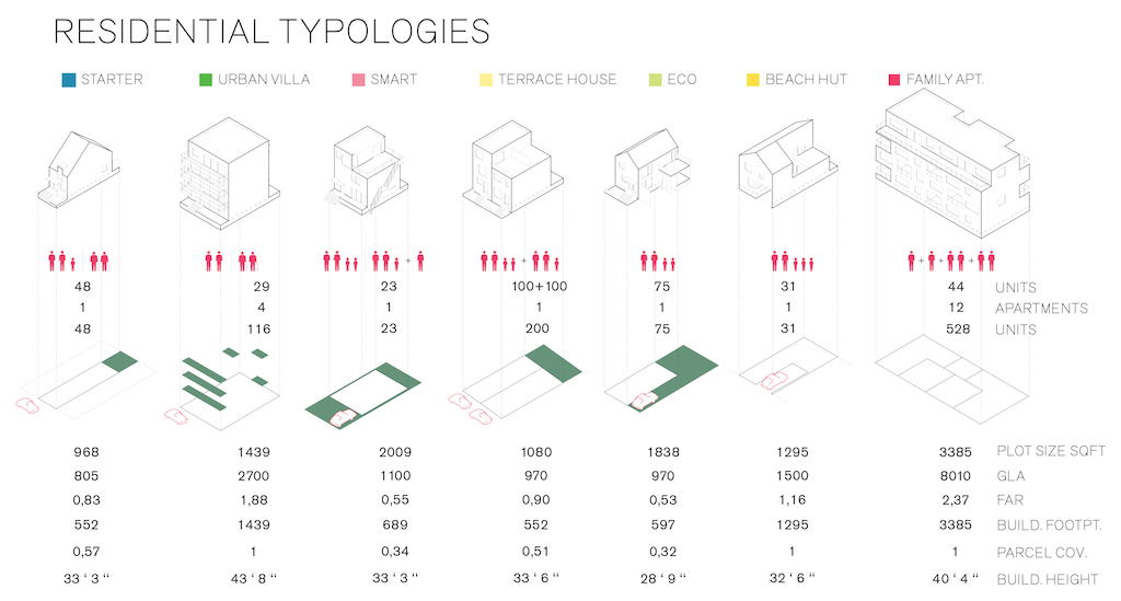
Housing typologies included in “Small Means, Great Ends” | Courtesy of White Arkitekter
In addition to physical interventions, the proposal calls for the incremental implementation of a community land trust as one step toward the creation of a mix of housing options with varying levels of affordability. Residents would be able to find new housing within the community as their needs change over time, with age, growing families, and fluctuating means. The plan also envisions robust transit connectivity for Rockaway residents: a new network of pedestrian and bicycle paths, privately operated dollar van services between MTA hubs, and an extension of the existing Manhattan ferry service help knit the new community into its surroundings.
White’s concept of anti-fragility moves beyond resiliency: instead of a community returning to its former state quickly after a disaster, it has the opportunity to become stronger. The attention to holistic resiliency and the community input process seems to have paid off. Wheeler noted that “inviting the community in and creating … a place to strengthen the economy and the physical resilience at the same time” is what set White’s proposal apart. Schuur expressed their teams’ satisfaction with being able to do so: “Normally, at least the competitions I’ve done, you do the competition and then you will meet with the community. … The opportunity to … already sit down with the community and get a feel for what they want was a really positive experience.”
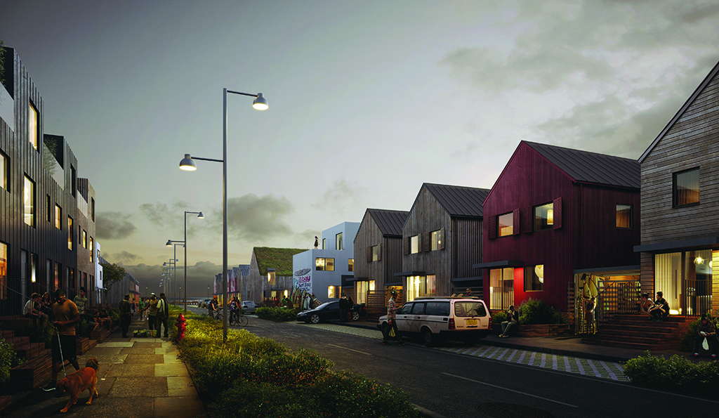
“Small Means, Great Ends” | Courtesy of White Arkitekter
Need, Risk, and Funding: A Study in Feasibility
Under current plans, 43% of the units in Arverne East would be required to meet affordability criteria for middle or moderate income individuals, making around 100 to 130% of the Area Median Income (AMI). HPD still owns the land, and the affordability requirements in the Land Disposition Agreement — the legal mechanism used to transfer the site to the development group — have not been finalized. With White’s proposal and the local Community Board calling for mostly single-family, market-rate development, the question remains whether the significant amount of investment required by the project and the embedded value of one of the last large, empty plots of City-owned land could be better used to address the city’s larger problems of affordability and inequality.
With Mayor de Blasio promising 200,000 new or preserved affordable units in the next ten years, a plot like Arverne East offers high potential for fulfilling this vision. The development’s current affordability criteria would lock out most local residents: the income-restricted rentals would still have monthly payments well over two times the median monthly rent for CB14 as of 2011[1]. But Jonathan Gaska sees more affordable housing development on the peninsula accessible to lower income populations as a lose-lose proposition. With the poverty rate in the CB14 at 20.8%[2], Gaska believes that “a mostly affordable community will not succeed. Businesses won’t come here and open if people don’t have disposable income.” And while building more affordable housing might seem politically necessary for the new administration, Gaska says that “if you talk to those who are in the affordable industry right now, who build those homes, it’s not successful. Not because there isn’t a will to build it—it’s because banks won’t lend to people to get mortgages.”
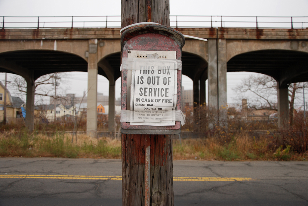
An out of service fire department call box on the border of Arverne East, 2010 | Photo by Nathan Kensinger
The affordability discussion may be subsumed by the question of financing. Bluestone has expressed that without public and private funding to address what looks to be between $100 and $200 million of infrastructure work before any development could begin on the site, the project can’t happen. Whether the developers will be able to leverage the federal funding coming into the region after Sandy for this development is yet to be seen. But if its treatment of Arverne-by-the-Sea is any indication, the City seems unwilling to finance such infrastructure, opting to pass on those costs to the developer. Gaska suspects that relying on private financing for that sum would almost completely erase the possibility for truly affordable housing, as banks may not have an appetite for that level of risk.
The question of whether anything should be built on the site, given its significant vulnerability in the face of the storms and the rising sea levels of the future, remains. And as Tom Kennedy, principal at Arup and a lead engineer on the project, noted, “there’s no one solution that’s going to keep your feet dry 24/7, 365 days a year… You can physically build anywhere; you’ve just got to do a series of things to make it work. The question is … how much energy and carbon are you spending? … Is it the right use of the tools and resources to do it? …From the developer’s perspective, is it financially viable?”
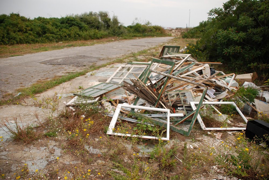
Debris in Arverne East, 2010 | Photo by Nathan Kensinger
And in what is meant to be a community primarily composed of homeowners, the developers will only make money if they sell homes. With the issuance of updated FEMA flood maps and the passage of the Biggert-Waters Flood Insurance Reform Act, this promises to be a significantly more difficult task than it would have been pre-Sandy: increased flood insurance rates are pushing housing costs in flood plains higher, what Gaska describes as the Sword of Damocles hanging over the district’s head. On March 21, 2014, President Obama signed into law new legislation mitigating some of the Act’s most publically contested effects on existing homeowners. However, while the new law will cap flood insurance premium increases for current policyholders and allow below-market insurance rates to be passed on to people buying homes in flood zones with taxpayer-subsidized policies, the effects of Biggert-Waters for the future homeowners of new development in flood prone areas like Arverne is yet to be seen.
Looking east toward Arverne East with Arverne-by-the-Sea, Water’s Edge, and Arverne Apartments visible; 2014 | Photo by Jonathan Tarleton
Ultimately, there is no guarantee that White Arkitekter and Arup’s vision for Arverne East will become a reality. Bluestone expressed satisfaction with the results of the competition, noting that he hoped they could incorporate as many of the good ideas that came out of it as possible. But while White and Arup continue to work with the developers on a plan that more fully takes into account regulations and economics, there is no specific timeline for breaking ground. An additional barrier to potential development would be the requirement of a new or supplemental Environmental Impact Statement (the original was completed in 2003), which Bluestone believes could stall the project long enough for potential federal funding to run out. If the contemplated development goes the way of its predecessors, the surrounding communities will remain, and with them what Gaska calls the “ghosts of Old Rockaway”: the vision of the grand hotels and amusement areas that defined Arverne of the late 19th and early 20th centuries. Add to those the ghost of unrealized urban renewal and what it has left behind: an already marginalized community physically splintered and stilted by unrealized plans. If Arverne East — replete with anti-fragile features — does come to fruition, the wisdom of building on this vulnerable site can only be determined in the next storm. As Kennedy said, Sandy is “only one instance of a major storm. Another storm coming in from a different trajectory … has different problems.”
For now there is consensus that the status quo in Arverne East, somewhere on a continuum between wasteland and unintended natural habitat, should not be preserved. Regardless of what is built there, and for whom, the pressure is mounting: Rockaway’s residents, leaders, builders, and designers only get one opportunity to create what will succeed it.

An Arverne East sidewalk, 2010 | Photo by Nathan Kensinger
NOTES:
[2] Ibid.
The views expressed here are those of the authors only and do not reflect the position of The Architectural League of New York.
Comments