
We are celebrating 15 years — and counting — of stories that are deeply researched and deeply felt, that build a historical record of what the city has been.
We are celebrating 15 years — and counting — of stories that are deeply researched and deeply felt, that build a historical record of what the city has been.
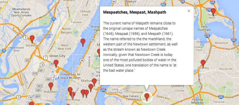
Screenshot from Constantine Valhouli’s map Early NYC Place Names
After a recent project wrapped up, real estate developer Constantine Valhouli had a little extra time on his hands. As someone fascinated by “the role of stories in how we perceive the built environment,” he opted to use it to do something he’d never done before: make a map. His first, the Music Map of NYC, is what may be considered — oxymoronically — a low-tech Google Map. It geolocates years of song about New York in places they reference throughout the five boroughs. About the Music Map, Valhouli notes:
“It was fascinating to see how simply arranging an existing data set on a map could suggest connections that might not otherwise have been apparent. For instance, the East Village played host to jazz legends, punk rock, and the indie scene of the ’00s. Count Basie and Etta James were singing about the same blocks that inspired The Dictators, The Fugs, and the Ramones. Or, on Eastern Parkway at the edge of Crown Heights and Brownsville, you’ve got Jay Z, M.O.P., and Bob Dylan. Of course, Brownsville was a very different place when Dylan and Jay Z were singing about it. And the questions that raises is part of what made the maps so much fun to create.”
Valhouli next turned his attention to a smattering of place names in the metro region. And while this may seem more a historical recording of past settlement than one connected with the changing nature of neighborhoods in the city, Valhouli ties this historical nomenclature with the evolving neighborhood titles and boundaries of today:
“Marketing is just another aspect of storytelling. Today, Chelsea is an established neighborhood. Thirty years ago, lower Chelsea was being marketed as “Greenwich Village North.” The East Village was once part of the Lower East Side that had been rebranded to leverage the cachet of Greenwich Village. The same thing is happening today when parts of Crown Heights were being marketed as Prospect Heights until Crown Heights developed its own cachet. Seeing the origin and evolution of these names is like knowing the etymology of a word: it allows you to read much more into the place.”
The way Valhouli makes his maps — a simple marker with embedded information — strongly privileges the spatial over the temporal. As he says, “this map view is almost the inverse of a timeline view,” which further allows connections to be made between stories that run across time but remain embedded in a common place. Given the enthusiastic reaction to the maps, Valhouli intends to keep up his amateur cartography for the time being. He produced another one plotting some key places in the lives of the Beat poets, something close to home after having lived in Allen Ginsberg’s old apartment.
There is no flashiness to obscure the information in these bare-boned plots, and for the purposes of discovering a new dynamic in the mythology of the city’s music, literature, and history, there’s no need for it. And while this pinpoint style is constrained in the kind of information it can present, it proves adept at showcasing a variety of information: street art; affordable housing units claimed as part of de Blasio’s housing plan; blocks novelists call home, in their characters’ lives or their own; businesses with drive-throughs. Each, with data tied to a single referent address, could be described in as simple a map. The free, user-friendly tools and ubiquitous information are there for other aspiring mapmakers to shed some light on the spatiality of the familiar. In the process, they can bring a new perspective to the many people always on the prowl for a different look at their hobbies, culture, and stomping grounds.
The views expressed here are those of the authors only and do not reflect the position of The Architectural League of New York.