We are celebrating 15 years — and counting — of stories that are deeply researched and deeply felt, that build a historical record of what the city has been.
We are celebrating 15 years — and counting — of stories that are deeply researched and deeply felt, that build a historical record of what the city has been.
In 1951, economist Colin Clark published the seminal paper “Urban Population Densities” in which he observed that urban population density tends to decline the further one gets from city centers. This made sense: land is cheaper outside the city center, so it doesn’t have to be occupied quite as compactly. In the years since, several more studies have looked at changes in an urban area’s average density over time. But few have looked at changes in density across both time and space within a particular urban area. So NYU professor Shlomo Angel, a senior research scholar at NYU Stern’s Urbanization Project, set out to do just that for Manhattan between 1800 and 2010.
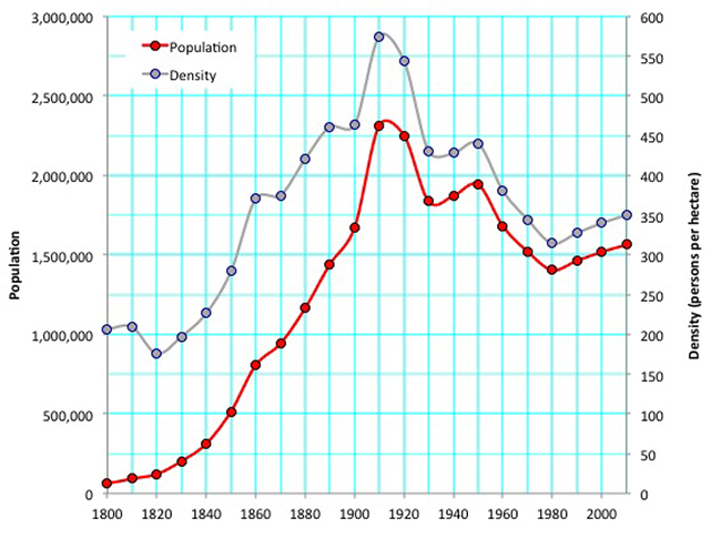
It is a story of a century-long intensification of people, jobs, and houses on the island, followed by an equally long — and equally dramatic — decongestion. In the second half of the 19th century, Manhattan’s population growth far outstripped the rate of new home construction. In 1910, Manhattan reached a peak population of 2.2 million, from which it has never since rebounded, even after modest growth in the past three decades. Angel’s research found that today, Manhattan’s population density is down a surprising 40% from 1910. Only by 1951 was the island completely built out, so to account for years when significant swaths of Manhattan was uninhabited farmland, Angel and his team counted only the portion of Manhattan that was built up and occupied by residents at each census year. No open space or parkland is ever included in their averages.
The Port of New York was a primary driver of both population and density growth in the 19th century. The completion of the Erie Canal in 1825 handed New York a share of all trade into and out of the Great Lakes region. Philadelphia and Boston would have to wait for train connections to the region to come 30 years later. By then it was too late; at various times in the second half of the 19th century, the Port of New York handled between 40% and 70% of all US trade. Transshipment (the transfer of goods from ship to another mode) and manufacturing took advantage of the dominance of the Port of New York, and businesses proliferated in close proximity. Low-paid work was abundant, and there was no shortage of foreign migrants arriving to fill the vacancies.
The demographics of New York’s settlers had an impact on the city’s make-up as well. Skilled labor, such as farmers coming from northern Europe, began to use New York merely as a gateway, staying for a few months before moving to homesteads in the Midwest. Unskilled, often poor immigrants from southern and eastern Europe tended to stay in New York, working dirty dock or factory jobs and living nearby. And for most of the 1800s, living close to your work was key, as walking was virtually the only mode of transport available to the poor urban class.
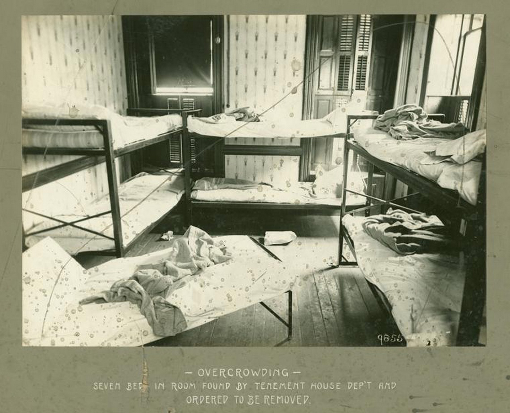
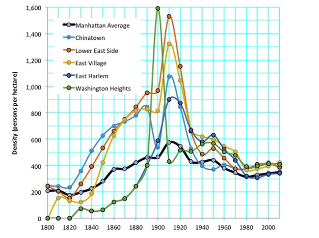
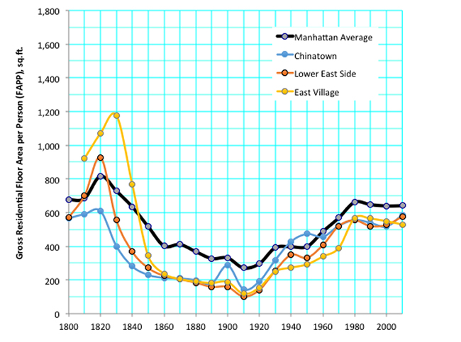
Between 1800 and 1910, density in urban Manhattan tripled from 200 to 600 people per hectare. Neighborhoods like Chinatown, the Lower East Side, and the East Village were significantly denser than the average, approaching 1,600 people per hectare. During the same time, floor area per person declined from 800 square feet per person to 270, with inhabitants of the Lower East Side averaging just 100 square feet per person.
It was not uncommon for multi-generational families to squeeze into three-room apartments with no running water and windows only at one end. On top of this, these apartments often doubled as shops or factory space, with residents making clothes or preparing food to sell. Jacob Riis, a photographer and author of the groundbreaking How the Other Half Lives, led the charge to reform housing conditions by exposing the squalor of the Lower East Side. Under legislation beginning with the Tenement House Act of 1901, New York builders had to give up precious floor area to make way for vertical light and air shafts and to run water and sewage systems to every dwelling unit. Rooms and apartments were eventually given minimum size requirements — regulations that are now being reexamined in response to the shifting demands of contemporary household demographics, dwindling land to build upon, and rising costs.
In the second half of the 19th century, elevated trains enabled suburbanization. The middle class could live farther from the city center — away from its noise and smells — and still feasibly commute back for work. Private rail companies built elevated train lines up several Manhattan avenues to land previously reserved for farms. But at 10 cents a ride, transportation to these new developments uptown was prohibitively expensive for the laborers working downtown.
The 1898 consolidation of the five boroughs increased New York City’s administrative area thirteen-fold, and its increased size justified the building of a subway system. The subway’s fare structure meant a larger share of Manhattan’s workforce could live as far out as the system would take them. Densities downtown declined drastically over the first few decades of the 20th century and eventually came to match Manhattan’s average.
All of this — improved building standards, the flight of the middle class, and the subway — contributed to reduced density. The mass production of the automobile further accelerated decentralization in the city, this time helping city dwellers decamp even farther afield and thereby delimiting a metropolitan region that now stretches across some 13,000 square miles, from Pennsylvania to Connecticut.
Angel says his findings have implications both for New York City and for cities in developing countries on the verge of explosive growth. In February, Mayor de Blasio said “densification and height” are integral to his plan to build or preserve 200,000 units of affordable housing over the next ten years. Prevailing trends complicate that goal. Land is scarce — and expensive.
Steel frame construction and the elevator allowed average Floor Area Ratio (FAR) — the ratio of a building’s total floor area to the size of the piece of land upon which it is built — in Manhattan to double between 1910 and 2010. The economics of redevelopment often promote the demolition of squat dwellings and construction of higher ones. But even though new buildings today are taller and bulkier, half of Manhattan’s existing building stock was built in the early 20th century, when average FAR was just 4.4. And tall buildings do not necessarily translate to higher densities. As we saw around the turn of the century, a big contributor to lower Manhattan’s density was the overcrowding of large families in small apartments. As Manhattan has gotten richer, its residents have demanded more space.
Of course, as any house-hunter from Beverly Hills or Beijing will quickly discover, even Manhattan’s rich occupy far less space than in other cities. That is in part a legacy of late-19th century builders like Rutherford Stuyvesant and Edward Clark, whose apartment buildings — such as the Stuyvesant Flats (1870) and the Dakota (1884) — helped to convince the well-off that luxury living needn’t be exclusive to single-family townhomes. But for most of the 20th century, Manhattan’s truly rich were confined to a few pockets around Midtown, and the dramatic, broad-based increases in living area for the poor had a greater impact on overall average densities. Meanwhile, readily available contraception, greater access to education, and a crackdown on child labor meant that by the end of the 20th century everyone — rich and poor, urban and rural — was having fewer children.
A close look at the data reveals that density in Manhattan actually stopped declining in 1980, and has since returned to growth, albeit at a modest rate. Since 1980, Manhattan’s population has grown 14%, and since occupiable land area is relatively fixed, density can go in only one direction as long as population growth continues. (The construction of several residential towers on landfill forming Battery Park City is an exception, but also a comparatively small addition to the borough’s buildable land.) Following its fiscal nadir in the 1970s, and with crime rates declining in the 1980s and ’90s, Manhattan’s desirability has since famously rebounded. Greater demand brings higher prices, and with higher prices, tenants also sometimes craft clever ways to stretch their rent dollar: by carving an additional bedroom out of the living room or by moving in with a significant other.
One urban housing phenomenon Angel’s analysis doesn’t address is the nationwide trend toward living alone, magnified in Manhattan by throngs of young professionals and relatively well-off seniors. According to NYU sociologist Eric Klinenberg’s 2012 book on the subject, Going Solo, the share of residential units in Manhattan housing just one person grew from 35% in 1960 to 46% in 1980 and is still higher today. This could help explain part of Manhattan’s de-densification, as studio and one-bedroom apartments once occupied by a family or a couple are rented by a single person. But it could also presage a re-densification. In 2012, the Bloomberg administration voted to reconsider New York’s minimum apartment size requirement. A team of developers was awarded a contract to build a tower of “micro-apartments” on Manhattan’s East Side. The units are to average around 300 square feet, with shared gathering space distributed throughout the building. The “urban lifestyle” this set-up purports to indulge is being trumpeted as a generational shift: millennials want to live close to transit and do their socializing out of the home, which, as the narrative goes, requires less personal floor area and benefits from more individuals living in close proximity.
The entire world faces questions of how to manage density in growing cities. Angel’s research found a worldwide decline in metropolitan area density over the course of the 20th century, regardless of level of development. If this means fewer people are living in crammed, unsanitary slums, that’s not a bad thing. But the explosion of informal settlements in and around cities in developing countries point to the cities’ expected growth — in population as well as area — to as much as four- or five-fold their current size in coming decades. And with such rapid growth underway, models for planning for this expansion are needed. Angel thinks the 1811 Commissioners’ Plan, that mapped out a future grid for Manhattan that was seven times larger than the then-occupied area, is a good example. Indeed, one of those 19th century commissioners foresaw a city more populous than any other “this side of China.” China may now take notice.
The views expressed here are those of the authors only and do not reflect the position of The Architectural League of New York.