
We are celebrating 15 years — and counting — of stories that are deeply researched and deeply felt, that build a historical record of what the city has been.
We are celebrating 15 years — and counting — of stories that are deeply researched and deeply felt, that build a historical record of what the city has been.
It’s been two years since Superstorm Sandy made landfall in the New York metro area, bringing newfound clarity to the urgent need for climate risk preparedness in the region. Large scale and high profile resiliency initiatives ensued, private companies and public agencies invested in hard infrastructure upgrades as well as green infrastructure interventions, and individual homeowners faced decisions about whether to rebuild or relocate. Whether regional or local, systemic or specific, Sandy demonstrated the need for action at multiple scales.
Public housing authorities in the region own and operate an enormous amount of property in the floodplain — in New York City, almost 20% of NYCHA’s conventional public housing was affected by Sandy — and their residents and buildings are some of the area’s most vulnerable. With severe financial constraints and an unrelenting list of immediate repair needs that compete with long-term planning for time, funding, and attention, public housing requires some of the most creative and yet practical responses to climate hazards. Public housing’s particular maintenance needs and operational challenges demand specific solutions geared to each site as well as scalable strategies that can be applied across large systems. But the lessons to be learned from proactive thinking just might have benefits that go beyond climate adaptation, with implications for more coordinated strategies for fiscal health and social solidarity.
Below, in the first in a series of posts considering the future of public housing in the context of climate change, Elizabeth Rush looks at a site a few miles west of New York City: the Booker T. Washington Apartments in Jersey City. Booker T., like many public housing sites in the region, sits on a former wetland. Though not waterfront property, the site is susceptible to chronic flooding from even mild weather events and sewer back-ups, and experienced devastating flooding during hurricanes Irene and Sandy. Earlier this year, the Jersey City Housing Authority partnered with Enterprise Community Partners to launch a design competition for an integrated storm water management plan that addresses various climate hazards facing Booker T. What might have been a straightforward, site-specific design challenge was instead framed as an opportunity to think about a much bigger picture, actively considering how strategies for Booker T. might be applied at sites across Jersey City and the region. As such, the project provides an opportunity to consider how to implement practical, responsive architectural innovation — in a financially, politically, and operationally strained environment — to ensure the safety, health, and vitality of some of our most vulnerable and valuable communities. –V.S.
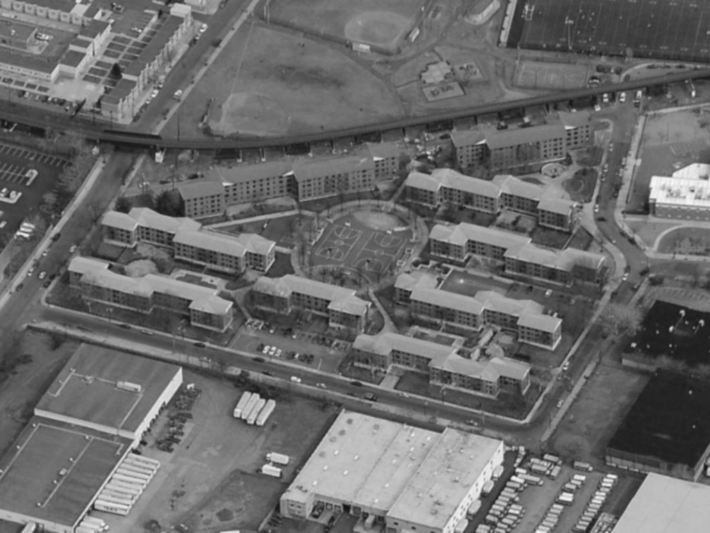
Aerial of Booker T. Washington Apartments | Photo via Stantec
Twenty years before Superstorm Sandy slammed into New York City’s harbor, awakening the metropolitan area to the reality of sea level rise, Ethel Jones fell into a massive puddle outside the basement of Building 8 at the Booker T. Washington Apartments in Jersey City. “I was running an errand for my mother, and when I came home soaking wet, she sure did scold me,” recalls Ms. Jones, who has been living at the public housing complex since she was four years old and is now affectionately called “The Mayor of Booker T.” by her neighbors.
As we tour the site, Jones points out at least a dozen other flood-prone areas. But Booker T. isn’t waterfront property. The Hudson River runs two miles due east, and the terminus of what remains of the Morris Canal — the city’s 19th century industrial waterway — is a little over a half a mile south. Seen from the air, the nine low-rise brick buildings don’t look like they would flood regularly. Even topographical surveys show that Booker T. rests a full 15 feet above sea level. But most of those 15 feet are relatively impermeable backfill used to turn a former wetland into real estate. When a heavy rain falls, runoff is channeled to low-lying areas: puddling occurs, sewer systems overflow, and basements flood with a mixture of rainwater and sewage. “In spring, the sewer system overflows once every two weeks,” Jones remarks, “No amount of Mr. Clean can get rid of the smell.”
Surveying damage at Booker T. post-Sandy | Photo by Sonya N. Hebert, via WhiteHouse.gov
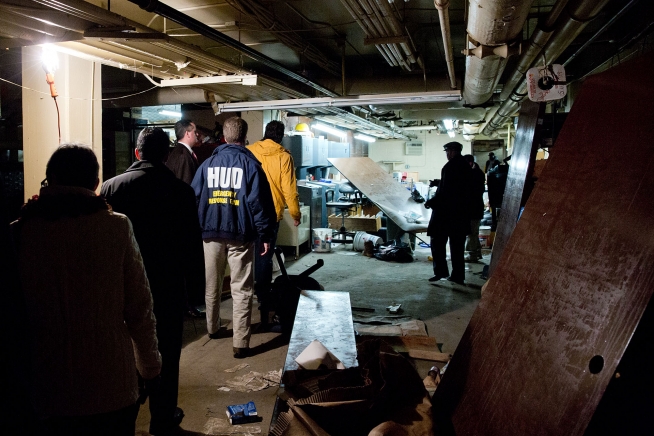
Big storms are worse. During Hurricane Irene in 2011, the floodwaters from the Morris Canal sped toward the site. The basements of Buildings 8 and 9 filled with seawater, taking out the boiler system. Recognizing the risk of locating key building management systems in the flood-prone basement, the Jersey City Housing Authority (JCHA), which owns and operates Booker T., used insurance money and HUD funding through a Community Development Block Grant (CDBG) to purchase new boilers and build a platform above the flood-line to support their new investment.
“We were in the process of punch-listing the new boilers the day Sandy hit,” recalls Brian Loughlin, the former Chief Architect of the JCHA. A few final tweaks and the boilers would have been brought on-line and the contract closed. Today, the walls of the boiler room are two shades of gray, a clear indicator of the new high water mark left by the floodwaters of Superstorm Sandy. The floors show significant signs of water damage, and the air is musky and thick. Those brand new boilers were not spared.
Then HUD Secretary Shaun Donovan, center, and Jersey City Mayor Jeremiah T. Healy, left, are briefed by Jersey City Housing Authority Chief Engineer Al Cenzano, right, on the flooding in the boiler room of a building at Booker T. | Photo by Sonya N. Hebert, via WhiteHouse.gov
“Sandy taught us that you can’t just replace what you lose to floodwaters, and you can’t just design for old standards,” Loughlin says, explaining a shift away from JCHA’s response to Hurricane Irene in 2011. “Booker T. was hit so hard because it already had failing infrastructure due to inadequate funding and deferred maintenance. Sadly, there were few politicians in the public sector calling for any sort of solutions other than, ‘kick ’em out and tear it down,’ so I started to wonder how do we get bigger picture thinking while raising awareness around the plight of Booker T., which is really the plight of so many public housing sites: lousy location, under-funded, primed for a disaster.”
This spring, the JCHA partnered with Enterprise Community Partners Inc.[1], a national non-profit that promotes affordability in housing, to run a design competition that called for an integrated storm water management plan for Booker T. Such a plan would increase the site’s overall resilience through strategies that reduce chronic flooding while simultaneously mitigating potential damage from larger storm events and sea level rise. And while site-specific solutions would be pursued, the Request for Proposals stressed a larger frame of analysis: “So much of what is being lauded as resilient design is developed in a vacuum these days,” says Laurie Schoeman, the Program Officer for the Resilience Program at Enterprise’s New York Office. “Bloomberg’s ‘A Stronger, More Resilient New York’ plan [which includes strategies like levees and adaptable flood walls] will flood half of Jersey City! So we wanted to think about site-specific solutions that took the big picture into consideration.”
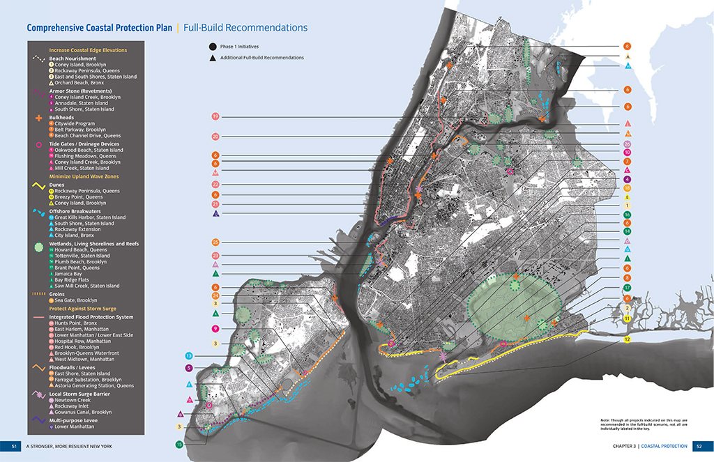
Map of the Comprehensive Coastal Resilience Plan proposed by the City of New York’s Special Initiative for Rebuilding and Resiliency (SIRR) | Image via SIRR
Stantec, the winning team, is currently at work on a suite of design “tools” that could be implemented at Booker T. and beyond. “On one end of the spectrum we are looking at how water is handled day-to-day on the site,” says Marc Wouters, Stantec’s Director of Urban Design. “There are green infrastructure solutions — rain gardens, increasing soil capacity, and designing a higher quality landscape for the residents.” Wouters is quick to add that at the other end of the spectrum, “There is no amount of green infrastructure that can absorb a major storm surge from the Hudson, but there you can start thinking about large scale strategies to protect multiple buildings, neighborhoods, or even Jersey City and the rest of the metro area.”
When Stantec visited Booker T., they sought out residents, gathering first-hand accounts of the flooding. Ms. Jones and her daughter, along with a dozen others, were instrumental in helping Stantec identify flood-prone areas and the frequency of their inundation.
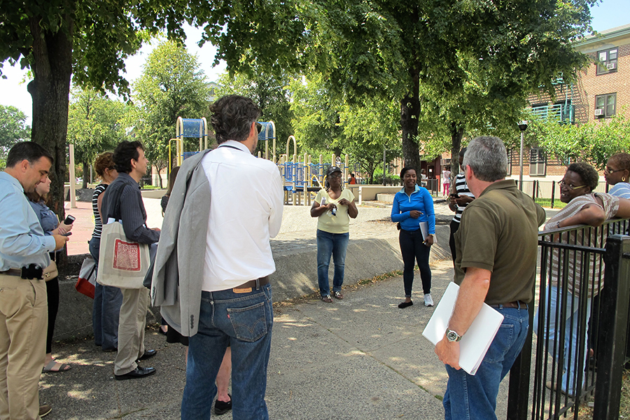
The Stantec team walks through Booker T. with residents and JCHA officials | Photo by Elizabeth Rush
Donna Walcavage, the landscape architect on the Stantec team, was impressed by the cohesiveness of the community at Booker T. and residents’ intimate knowledge of the different kinds of flooding that threaten them. Along with designing landscape plans that will facilitate storm water absorption, Walcavage proposes removing the physical barriers around the green spaces at Booker T. to further promote the on-site social community and beyond. “In the end, in a storm it is not the boiler that gets residents through. Residents get each other through. We see this well displayed at Booker T., but still it can be advanced to deepen connections that facilitate interactions with the broader community as well.”
“I am glad they came out here to talk with us,” remarked Lakenya Douglass, who accompanied Ms. Jones during the Stantec site walk through. “We used to have baby showers down in the community room. It was also our game room, but it just keeps flooding and we can’t keep building it back,” she adds. The curving wooden desk that marks the entrance to the community room sits abandoned. Fresh puddles spot the floor.
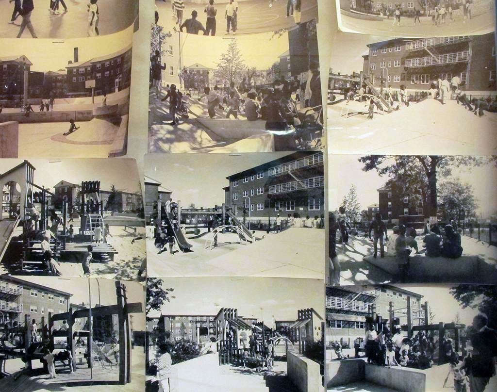
Historical photos of Booker T. on a community bulletin board | Photo by Elizabeth Rush
When seen through the lens of history, the flooding that happens at sites like Booker T. — from minor, chronic, combined-sewage-overflows to the inundation that left residents without heat, electricity, or water for days after Sandy — makes sense. The wetlands of New York and New Jersey were once quite extensive, and today much of the region’s at-risk housing rests atop what was always soggy land. Ted Steinberg, author of Gotham Unbound, reminds us that “in 1904, there were roughly 300 square miles of wetland within a 25-mile radius of City Hall in Manhattan. 300 square miles is an area about one-quarter the size of Rhode Island.” The exponential growth of the New York metropolitan area, driven in part by its unrivaled port, fueled the backfilling of these wetlands to make way for piers and related industry, thereby destroying a natural system of storm buffers.
With over 520 miles of coastline, New York City has more people living in high-risk flood zones than any other urban area in the United States.[2] The vast majority of those living along the coast are low to middle income, which may seem counterintuitive given the explosion in luxury waterfront developments in the last decade. As the Port Authority shifted major shipping operations to Newark and Elizabeth in the mid to late ‘40s waterfront were largely abandoned and old, mixed industrial areas were targeted for redevelopment. Back then the waterways of New York were so polluted that living alongside them was a nuisance rather than a pleasure.
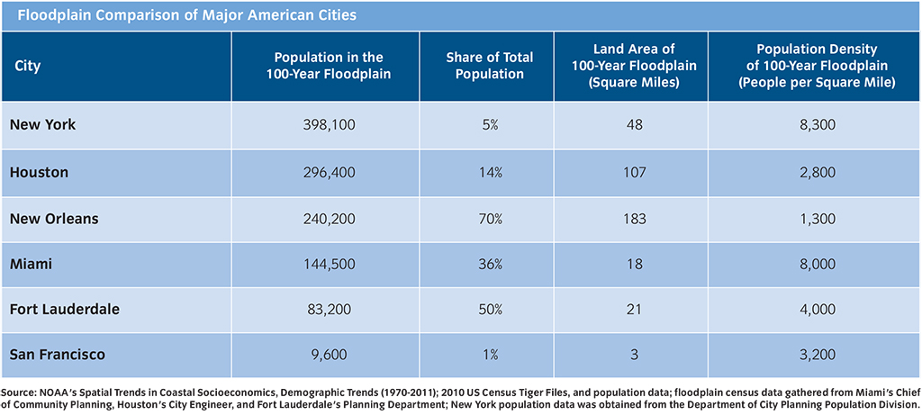
Table via SIRR
“No one was thinking, let’s put public housing in a flood zone,” says Nicholas Bloom, a public housing expert and professor at the New York Institute of Technology, “but most of NYCHA’s buildings were erected on land that was vacant, in declining and substandard neighborhoods, or transitioning out of public use, as were most neighborhoods near the water at the time.”
Public housing authorities, such as JCHA and the New York City Housing Authority (NYCHA), now own and manage more housing in the floodplain than any other landlords in the metropolitan area. Over 1/3 of the residential units in New York City affected by Hurricane Sandy are part of the city’s public housing portfolio.[3]
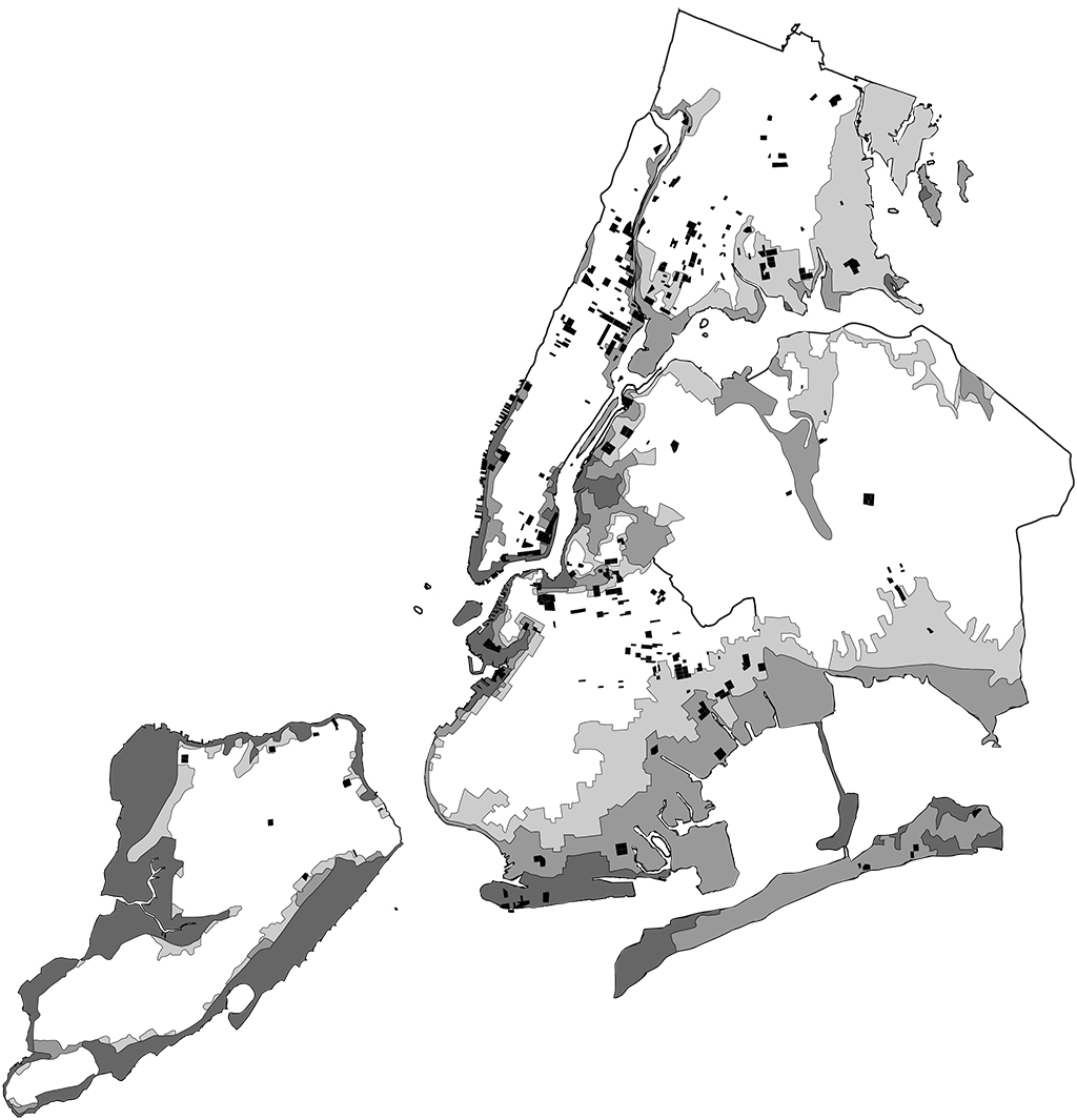
NYCHA properties (black) and the New York City floodzones (grays) | Map courtesy of Andrew Bernheimer and David Leven, NYCHAPEDIA; map sources: www.nyc.gov/html/nycha/html/about/about.shtml; www.floodzonenyc.com
While the size of Jersey City and New York’s housing authorities differ dramatically (Jersey City owns about 3,000 units while NYCHA owns more than 175,000), neither is financially primed to make the kinds of large-scale capital improvements needed to become sea-rise ready. After years of federal disinvestment, many housing authorities are struggling just to meet existing operational costs. NYCHA is currently running a $77 million deficit and has $18 billion in unfunded capital needs for basic building improvements like leaking roofs, cracking facades, and broken elevators.[4] “People who are managing public housing are underwater already,” says Eric Klinenberg, a sociologist well known for his research into climate change, risk, and disaster. “Telling them that they need to worry about the storm surge that could be coming five, ten, a hundred years from now seems absurd when so many buildings need so much basic work. But we have no choice, we must look toward the future — the seas are rising and we have to begin to think about how to protect these residents.”
Down at NYCHA’s 250 Broadway headquarters, the attitude is proactive, if overwhelmed. The walls are covered in maps marking inundation and the flood zone extension that the Federal Emergency Management Association (FEMA) is expected to roll out in 2016. 31,000 NYCHA units were built on land that is now considered at high risk of flooding. As this risk is reassessed in the face of rising sea levels, those numbers will only increase.[5] The new FEMA flood insurance rate map will likely double the number of low-income residential units in the flood zone in New York City.[6] According to Jessica Yager of the Furman Center, 80% of the rental units in the 100- and 500-year floodplain are affordable housing — either public, subsidized, or rent-stabilized housing — and 28% of those units belong to NYCHA.
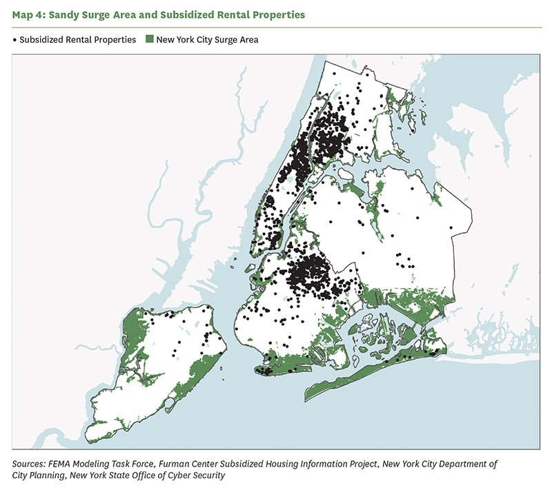
Map via the Furman Center
In Jersey City, securing funding for the design initiatives that Stantec hopes to implement at Booker T. will require creative thinking. The team is looking at how to incorporate environmental and quality of life improvements, as well as damages avoided, into their cost-benefit analysis. By putting a dollar value on these often overlooked benefits, Stantec is hoping to make their innovative proposals conventionally attractive.
As money for post-Sandy improvements is made available through the federal Department of Housing and Urban Development (HUD), housing authorities in the New York metro area have struggled to access their fair share. One leader in the public housing sector stressed that the grants, made through HUD’s Community Development Block Grant Disaster Relief Fund (CDBG-DR), lacked the distribution mechanisms necessary to channel funds to the housing authorities. This challenge comes on top of larger funding issues, which many of the public housing experts interviewed for this piece (both employees of authorities and external observers) say will continue as long as public housing is seen as a handout for undeserving individuals and a bad use of tax dollars. Of the $1.7 billion of CDBG-DR funds allocated to the City’s tremendously slow, poorly managed “Build it Back” program, NYCHA will receive only $308 million. The lion’s share of the money is earmarked for rebuilding the 1-4 unit homes that account for only 1/3 of units at risk for flooding.[7][8]

Equipment in a Coney Island Houses boiler room after Sandy | Photo via NYCHA
FEMA advocates flood-proofing single-family homes by lifting them up on stilts, a “solution” that costs from $30,000–$90,000 per home. But no one knows just how much it will cost to flood-proof public housing; as of yet, there is no preferred method. One commonly suggested retrofit is to move all of the building systems above the flood line. In public housing, relocating utilities such as boilers and electrical systems to residential floors is shunned because of the resultant loss of revenue and units. Instead engineers typically advocate for rooftop relocation or the construction of a detached, raised utilities structure.
A recent study by the Furman Center estimates the cost of putting a boiler on the roof of a single 19-story tower-in-the-park building at upwards of $2.5 million, while a 6-story building like Booker T. comes in at $1.26 million. Regardless, the money NYCHA did receive through HUD will cover only a small portion of what is necessary to retrofit their more than 400 at-risk buildings. Last month, FEMA awarded NYCHA an additional $108 million to make the Coney Island Houses more resilient, a sum which will cover retrofits to five of the most severely storm-damaged buildings in the authority’s portfolio.
Michael Rosen, the Vice President for Disaster Recovery for NYCHA, stresses the importance of this money to the design process; “We couldn’t have done the design without knowing what kind of budget we would have.” Rosen plans on allocating the FEMA money to build an elevated boiler building, install back-up generators, and to remove and replace existing conduit and structural elements damaged by the storm at the Coney Island Houses. “We hope to use FEMA funds at other sites as well, but we have to apply on a site-by-site basis,” Rosen adds. While the compartmentalized manner in which that funding is allocated promotes feasible, local solutions, it also risks neglecting the larger picture.
···
The implications of how best to design for resiliency with elusive and limited funding could extend far beyond the public housing sector. “Developing innovative resiliency designs, mitigation strategies, new ways to deal with the rising sea levels that also increase the sense of community — all of these initiatives have the power to change the way people perceive public housing,” Loughlin says. Public housing communities are surrounded by what urban designers often describe as “cultural moats.” The stigma around public housing along with the spatial separation of their layout isolates complexes from the larger neighborhoods of which they are a part. These cultural moats are particularly problematic during disasters — they act as barriers to outreach, service, and, perhaps most importantly, funding for capital improvements. But, Loughlin continues, “by redesigning public housing sites to not only stay dry during the next storm, but to have parks and playgrounds, community spaces, and to offer programs and services that benefit all the residents of the neighborhood, not just those of Booker T., we can start to change those awful perceptions.” Public housing is primarily funded by the federal government; if perceptions change, so too might Congress’ cold attitude towards public housing budgets.
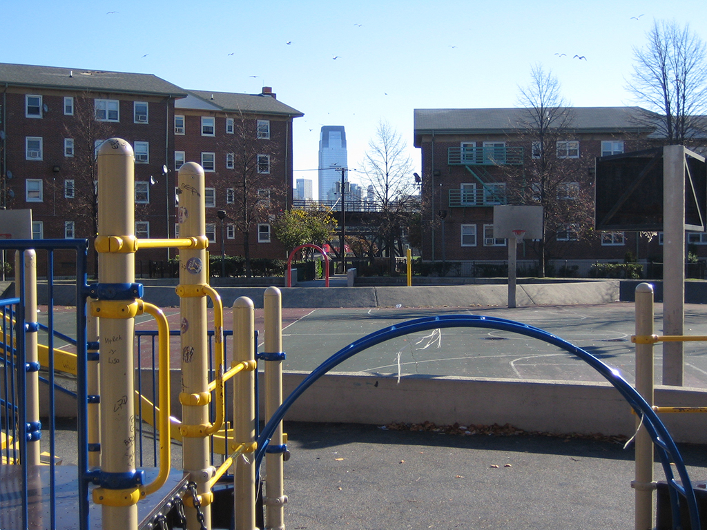
Booker T, looking toward downtown Jersey City | Photo courtesy of the Jersey City Housing Authority
Given that roughly 15% of the 250,000 units threatened by sea rise in New York City rest in public housing, treating them as vital to the metropolitan area’s overall resiliency is both ethical and wise.[9] Public housing sites could, if retrofitted well, serve as community centers from which disaster response efforts could be organized, and engaging residents as partners in the process of resilient design could help reconnect these public housing sites with their surrounding communities.
The complex challenges to providing safe, affordable, sea rise-resilient housing in the New York metropolitan area are intimately linked with the need to clarify who is responsible for retrofitting and maintaining equitable coastal communities in the future. According to Reuters, over the past three decades, the United States government has authorized “more than $47 billion in direct federal spending on climate change research.” And yet, Congress still hasn’t passed a major piece of legislation to improve opportunities for regional or inter-agency cooperation in mitigating the long-term effects of rising sea levels.[10] Without national legislation, housing authorities are left to address the specter of sea level rise in a frustratingly piecemeal fashion. Some build elevated boiler structures, others install rainwater gardens and contemplate the hydrological history of the building sites. But despite owning and managing more residential units in the floodplain than any other entity – private or public – they have very little power to implement solutions that extend beyond one property. More integrated solutions, rooted in the kind of systemic, scalable thinking that inspired the project at Booker T., have the power to connect public housing to the cities in which they will continue to play a vital role. And it is these types of integrated solutions that climate change demands — locally, regionally, and globally.
For more on the work of Brian Loughlin and Eric Klinenberg, read their Urban Omnibus interviews: “Hard Units: A Drive through Jersey City with Brian Loughlin” and “Toward a Stronger Social Infrastructure: A Conversation with Eric Klinenberg.” You can also find additional coverage of Superstorm Sandy in The Architectural League’s digital feature “Meeting the Demands of New York’s New Realities” and extensive coverage of public housing here on Urban Omnibus.
NOTES:
[1] JCHA is part of the Learning Collaborative for Multifamily Housing Resilience, a consortium of twelve affordable housing organizations from around the region that convene to develop resiliency in affordable housing.
[2] “Rising Tides, Rising Costs,” Center for NYC Neighborhoods, September 2014.
[3] “The City of New York Action Plan,” NYC Recovery/Community Development Block Grant Disaster Recovery, July 2014.
[4] “Public Housing in New York Reaches a Fiscal Crisis,” Mireya Novarro, New York Times, August 11, 2014.
[5] “The Price of Resiliency: Can Multifamily Housing Afford to Adapt?” NYU Furman Center, July 2014.
[6] “Rising Tides, Rising Costs,” Center for NYC Neighborhoods, September 2014.
[7] “Community Development Block Grant – Disaster Recovery (CDBG-DR) Proposed Amendments to Action Plan: Amendment Five,” The City of New York, December 2013.
[8] “The Price of Resiliency: Can Multifamily Housing Afford to Adapt?” NYU Furman Center, July 2014.
[9] “The Price of Resiliency: Can Multifamily Housing Afford to Adapt?” NYU Furman Center, July 2014.
[10] “Federal Climate Change Funding from FY2008 to FY2013,” Jane A. Legget, Congressional Research Service, September 2013.
The views expressed here are those of the authors only and do not reflect the position of The Architectural League of New York.