
We are celebrating 15 years — and counting — of stories that are deeply researched and deeply felt, that build a historical record of what the city has been.
We are celebrating 15 years — and counting — of stories that are deeply researched and deeply felt, that build a historical record of what the city has been.
Despite the waning, mild winter, every East Coaster is familiar with mountains of snow that leave municipalities at the mercy of a mere mineral: salt, the savory staple and go-to de-icer. Literally and figuratively mundane, salt is taken for granted as it pours from the back of sanitation trucks. Yet the crystals that thaw our streets arrive in the city imprinted with the logistics of mammoth operations so streamlined that we forget their geography or that they even occur — until there’s a bottleneck.
Much of the rock salt spread in New York City makes its way by truck, boat, and barge from Chile’s Atacama Desert to the working waterfront of Staten Island. Through meditative prose, exacting drawing, and striking, original photography, Dan Adams and Marie Law Adams of Landing Studio chart New York’s salt story — one that stretches back to the Mesozoic era, spans contemporary oceans and continents, and bears the marks of towering bridges, deep channels, and cavernous hulls. It is a tale of a global commodity meeting the local environment that starts with a bang and ends with a crunch underfoot. –J.T.
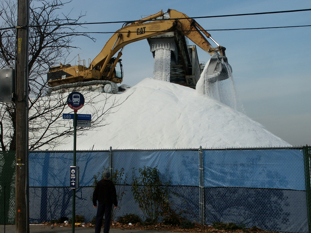
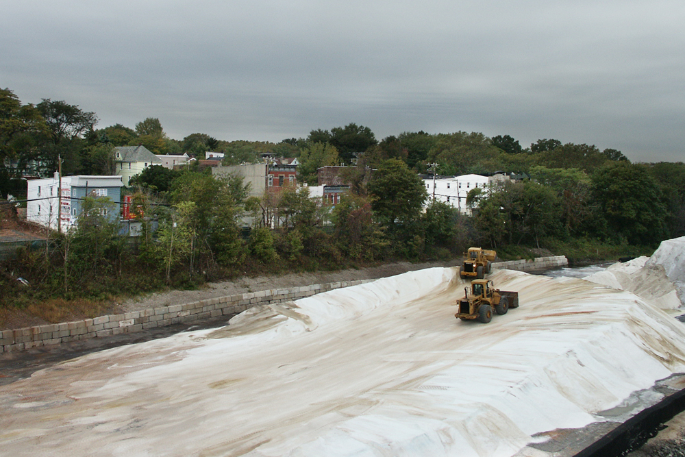
The last remaining New York City salt dock occupies a long and narrow parcel on Staten Island’s North Shore. The salt pile is surrounded by a buffet of urban characters: the Kill van Kull maritime superhighway along its north edge and Richmond Terrace — a winding spine of single-family homes, apartment slabs, local monuments, and businesses — to its south.
Salt from mining sites across the world arrives at the Kill van Kull for distribution on winter roads. When it snows, the salt is spread as a thin crust over the city’s streets, as one crystal, salt, cancels another, ice. The salt dissolves the snow into liquid brine by lowering its freezing point. But unlike the concrete or asphalt that flow into the city and freeze into plazas, sidewalks, and streets, salt’s tenure is relatively brief. Briny water travels the shallow topography of the roadways, eventually making its way back to the ocean from which it came.
More than just repositories of a de-icing agent, however, salt piles are an artifact of the waterfront’s material, corporeal past. While other global cargos now arrive hidden in shipping containers or pipelines, salt piles are built up in peaks and ridges in the open air of the urban shore. The pile is a momentary architecture in an infrastructural process, a visual register of global arrival — and a place where it is still possible to read the primary industrial operations that support the city.
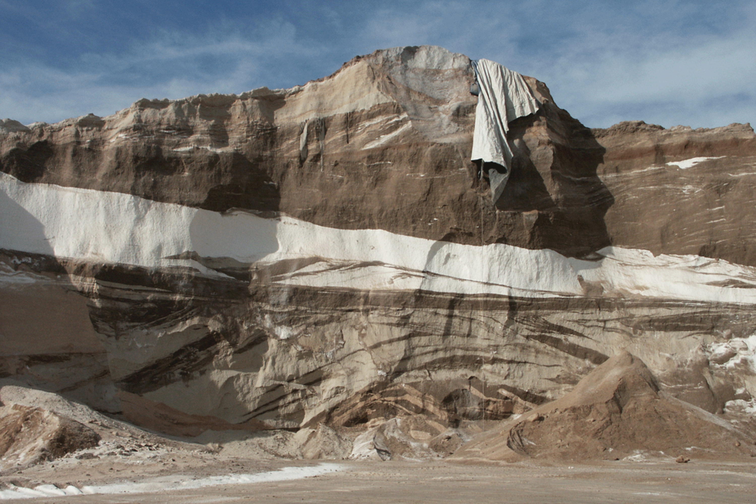
Today, most of the salt piled in Staten Island and spread on New York City streets comes from Chile, Australia, Northern Ireland, Mexico, and the Mediterranean Sea. It is neither a scarce nor foreign material. The largest quantities of salt are subterranean deposits left from past seas, and they are found all over the world, including in and around Syracuse, New York. Distinct and recognizable colors, textures, and even smells embedded in the salt crystals display the different geologic characteristics of the places where the salt is harvested and the methods through which it is extracted. As ships arrive from various countries of origin, the pile’s layered construction reworks global geographies and millions of years of geologic history — a type of global coalescence legible in the urban landscape.
All of these salts are evaporated from saltwater lakes and oceans, but the eras of this process differ dramatically. North of Belfast in Carrickfergus of County Antrim, Northern Ireland, rock salt is extracted from a halite vein 1,100 feet below ground. Some 250 million years ago, the Zechstein Sea spread across a region that now includes the North Sea, Germany, Poland, and portions of the United Kingdom. At the transition between the Permian and Triassic periods — when the Earth’s continents were still united as Pangea — the Zechstein Sea evaporated, and the salt crystallized. Miners now traverse this geologic horizon, and the salt of 250 million years ago is brought to the surface and re-entered into contemporary urban chemistry.
Today, Carrickfergus salt is identifiable in New York City by its dark brown color. Bright white salt, on the other hand, comes from the arid coastlines of the Baja Peninsula in Mexico and the Dampier Archipelago along the western coast of Australia. While Northern Irish salt evaporated through geological process over millions of years, industrial producers accelerate the process in Mexico and Australia by trapping ocean water in manmade lagoons. Evaporation ponds on the Baja Peninsula cover 100 square miles, approximately twice the land area of Staten Island.
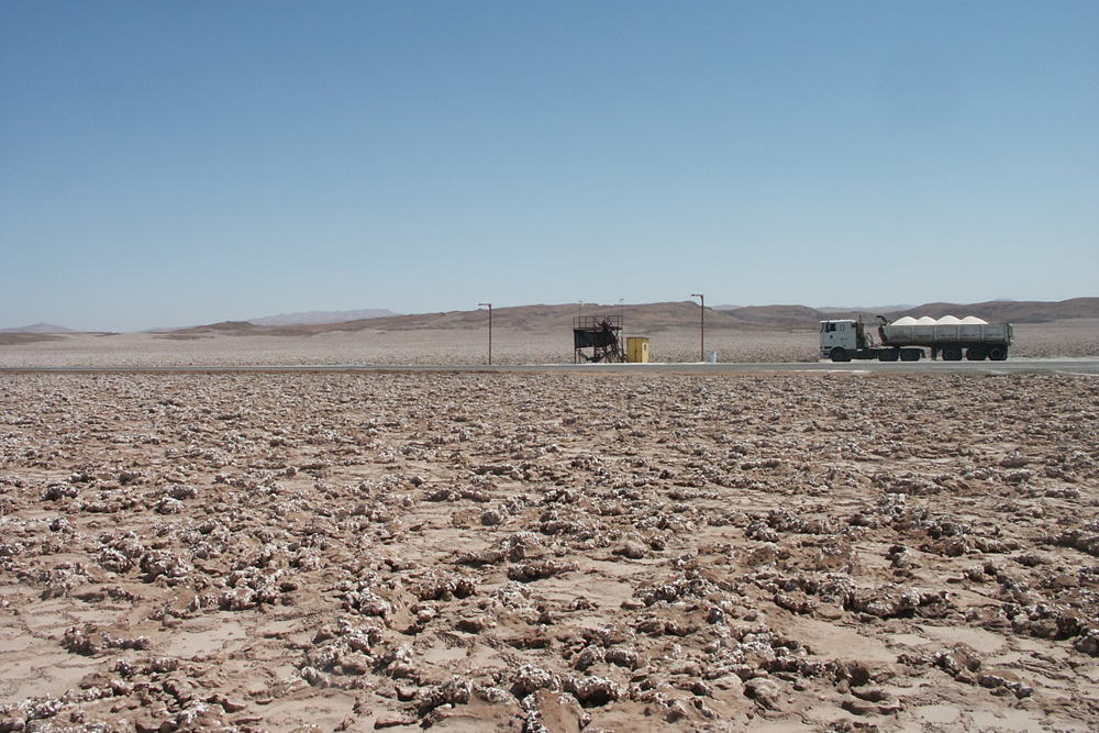
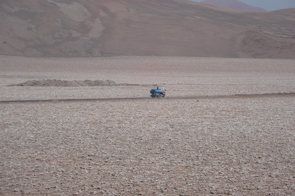
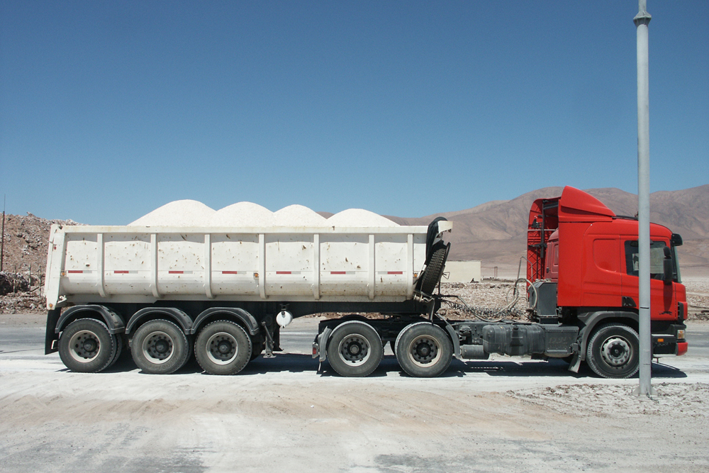
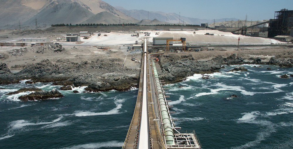
But the salt most commonly seen in the strata of the Staten Island pile comes from the Atacama Desert in Chile — a region often described as the driest in the world. Many factors make the Atacama an epicenter of mineral resource industries. The salt flats — salars — are located directly at the earth’s surface. Lack of rain and its associated run-off preserves the salt in an extraordinarily pure state. Most remarkably, such a parched landscape is close to the ocean. A 40-minute truck route links the salars to the port, and to the global transport it facilitates. Effectively, the capitalized resource at these mines is not the salt itself, but rather a unique mixture of climate and coastal geography easily inserted into the global economy.
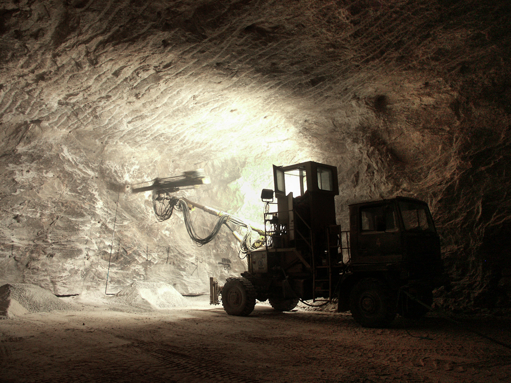
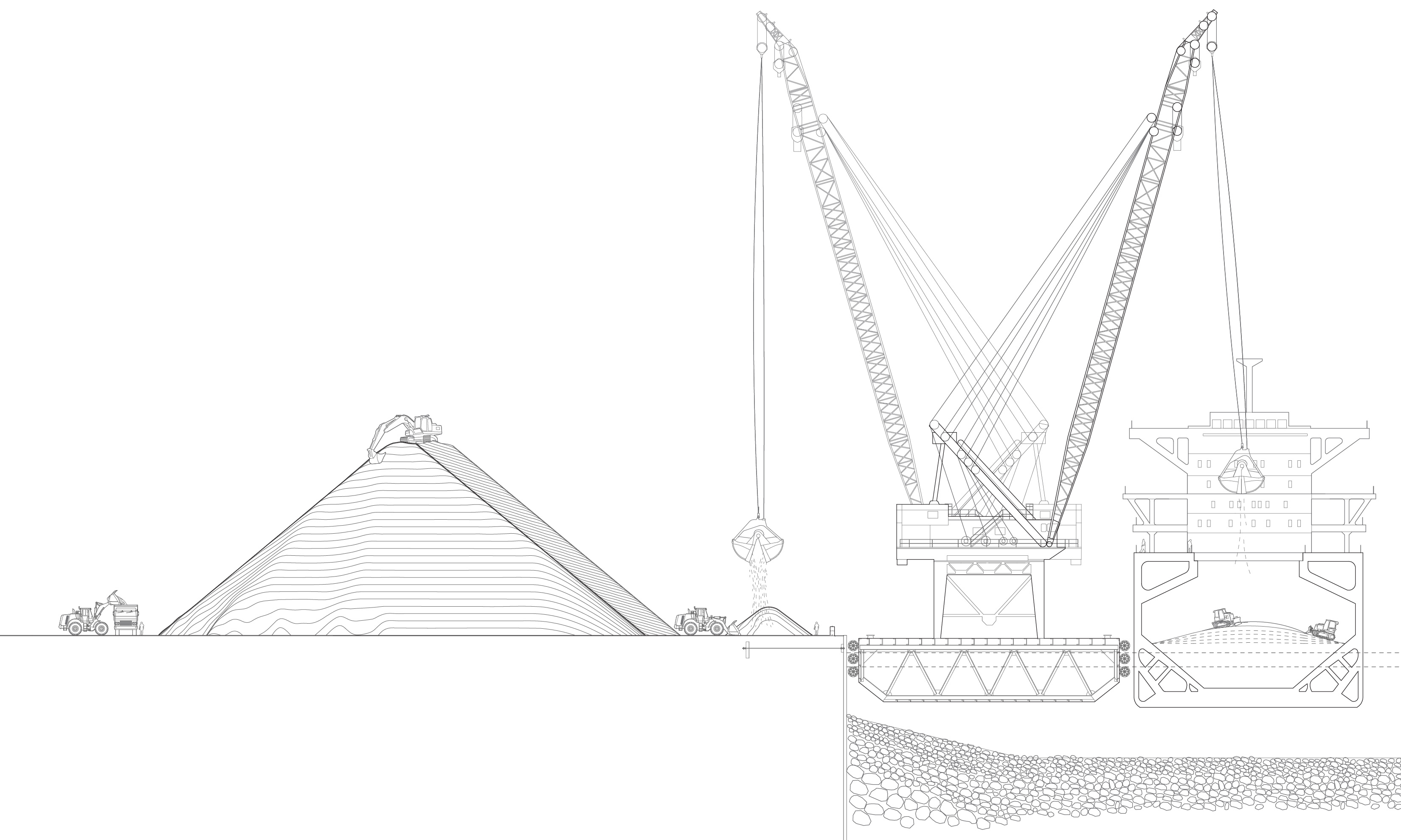
To start the globally scaled assembly line that crosses continents and oceans and culminates on the shores of Staten Island, salt is cracked from the salars by explosives. The Atacama’s open pit mine is made through subtraction, as ramps blasted into the earth allow machines to dig ever deeper. As a pit deepens in Chile, a pile rises in New York City.
Out of the pit, the salt is conveyed through a crushing plant and then descends by truck to the coastline. While the roadways of New York are spread with Chilean salt to prevent the crystallization of ice, the roads linking the salars to their Pacific port are themselves constructed from salt, and sprayed weekly with water to maintain a bonded crystalline structure that traffic would otherwise pulverize. About two weeks after being loaded by conveyor into ship holds in Chile, the salt enters New York Harbor.
In his seminal book Fish Story, Allan Sekula describes the shrouding of material flows by containerization and its effect on the relationship between cities and their material footprints:
“If the stock market is the site in which the abstract character of money rules, the harbor is the site in which material goods appear in bulk, in the very flux of exchange. … But the more regularized, literally containerized, the movement of goods in harbors, that is, the more rationalized and automated, the more the harbor comes to resemble the stock market. … Goods that once reeked — guano, gypsum, steamed tuna, hemp, molasses — now flow or are boxed. … The contents anonymous.”
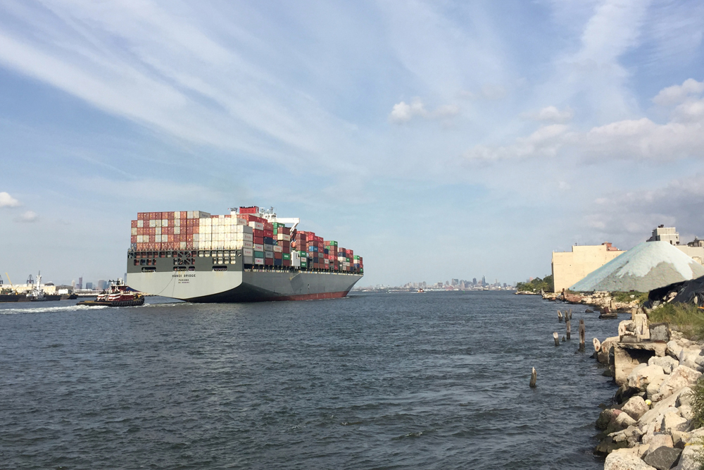
The Port of New York and New Jersey played a pivotal role in this loss of global legibility on local shores. In 1956, Malcolm McLean, a pioneer of global shipping logistics, launched a modified World War II T2 tanker named the Ideal X from the Port Newark-Elizabeth Marine Terminal. The Ideal X is popularly recognized as the ship that inaugurated a new era in the movement of global goods through use of the shipping container — effectively a truck trailer capable of being detached from its running gear and chassis, allowing cargos to be loaded, unloaded and, most importantly, stacked in the holds and on the decks of ships without re-handling the container’s often variable and unwieldy contents.
This technological adaptation, pioneered just over a half century ago, has rippled across the globe, altering every dimension of ports and harbors and their interface with cities. With containerization, a few cranes calibrated to standardized lifting rigs replaced hundreds of longshoremen that once unloaded each ship. The finger piers that once encircled Manhattan to facilitate the exchange of goods between the global network of the sea and the grid of the city quickly became outmoded and were abandoned. No longer were the textures, weights, and organic properties of the goods revealed in the bulges, geometries, smells, and leaks of the different crates, barrels, and sacks as they were unloaded and stocked on the shores of the city. Pier 42, operated by a Dole company affiliate and the last active cargo pier in Manhattan, received its final shipment of bananas in 1987.
Out of this transformative history, the salt pile on the North Shore of Staten Island emerges as a unique urban landscape where the industrial processes supporting the city are still legible.
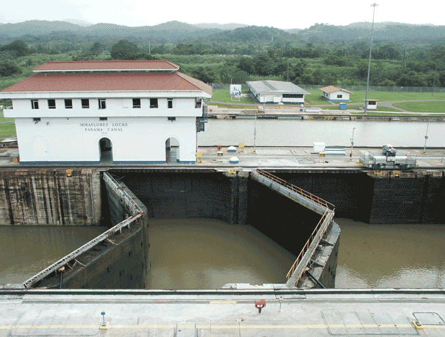
After travelling across the Pacific Ocean, Panama Canal, Gatun Lake, Caribbean Sea, and up the Atlantic Coast, the ship carrying Chilean salt to the Staten Island pile arrives at the southern end of the Ambrose Channel, a few miles east of Sandy Hook, New Jersey. The Ambrose Channel is a critical point at which the open sea transitions into a constructed infrastructure. This central dredged waterway provides a consistent, 50-foot-deep, obstruction-free route for Panamax ships to the Narrows, the gate to New York Harbor. The Panamax is the largest size ship that can squeeze through the original locks of the Panama Canal, able to carry 5,000 containers or Twenty-Foot Equivalent Units (TEUs) along the way. But unlike container ships, those that deliver salt are dry bulk carriers designed to hold heavy, unpackaged cargos inside giant steel bowels of the ship.
Entrance to the channel marks the beginning of a process to down-scale the ship and its contents from ocean to city. The captain hands the vessel over to a Sandy Hook pilot, a local guide who steers the 800-foot-long foreigner through the complex submarine topography and unfamiliar hazards hidden below. As the salt ship passes beneath the Verrazano-Narrows Bridge and into the Upper Bay, trucks carrying salt from Staten Island to Brooklyn and beyond might pass overhead.
The Narrows, the Ambrose Channel, and the Verrazano define the walls, floor, and ceiling of a spatial gateway. This threshold is a point where the global flows intersect with the local, urban fabric. The height of the Panamax ship shapes the infrastructure of the city — the bigger the ship, the bigger the bridge, and the longer the on-ramps. At high tide, the distance from water line to the Verrazano roadway, or the bridge’s air draft, is 228 feet. This spatial envelope is directly extruded all the way from the Panama Canal, where the Bridge of the Americas spans the entrance to the canal 201 feet above the high-water line. The Verrazano gives an extra 27 feet for good measure. If only the same could be said for the Bayonne Bridge, whose air draft is just 151 feet. The Port Authority of New York and New Jersey is raising it to accommodate the bigger vessels that will come as the Canal is widened.
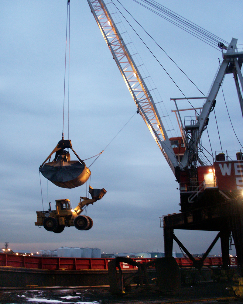
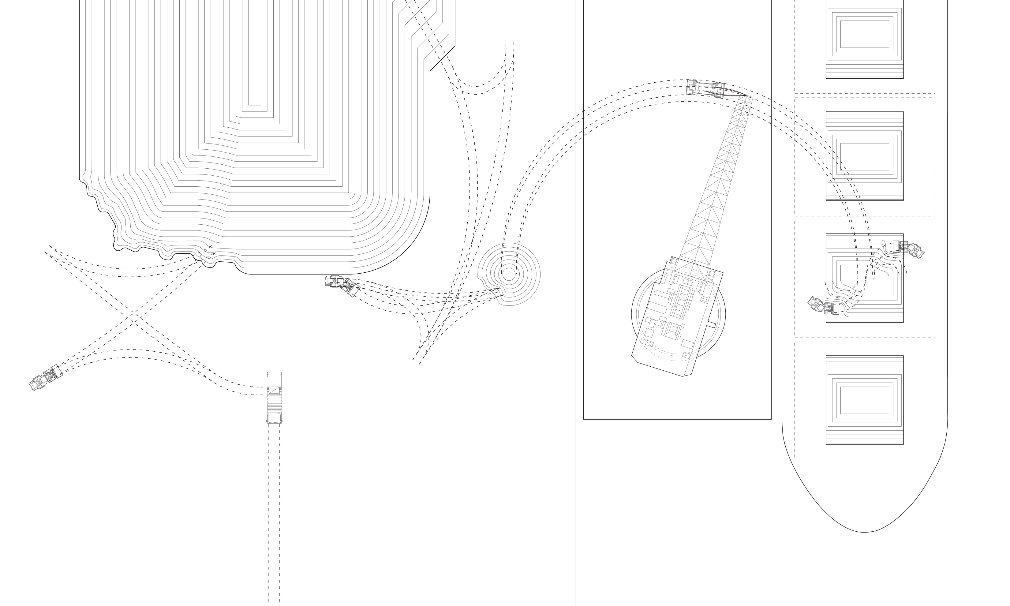
The Panama Canal reappears elsewhere in New York Harbor in the depths of navigation channels and networks of submarine telecommunications, electrical, water, and vehicle tunnels that stitch the city together. Salt destined for the Staten Island dock once had to be unloaded from Panamax ships by a barge crane while anchored in the middle of the harbor. With a lighter load, the ship floated higher and could safely navigate to shore. In 2008, the dock’s ship berth was dredged to match the 42-foot draft of the Panama Canal locks and to allow a team of tugboats to position Panamax ships directly into the berth, without “lightering.” Here the module of the Panamax is transposed into the harbor’s physical form, a negative mold of the ship imprinted into the topography of the sea floor.
The ship will stay at the berth for approximately one week while the cranes work to unload it. Throughout this period, the dock negotiates the fixity of land with the fluidity of the sea. The implements of this mediation are high strength mooring lines that tighten and slacken on automated winches as the tides come and go and cranes unload cargo. The salt pile and the ship seem to grow simultaneously, as the ship buoys up from the sea with each bucket-full of cargo discharged.
Just as buildings are anchored to the ground by foundations, ships are stabilized at sea by balancing their weight and buoyancy. After the ship unloads its cargo but before it returns to the sea, sea water is pumped into the cargo holds and ballast tanks to counteract the displaced weight of its discharged cargo. After an evaporated ocean is removed from the ship holds, the contemporary ocean takes its place.
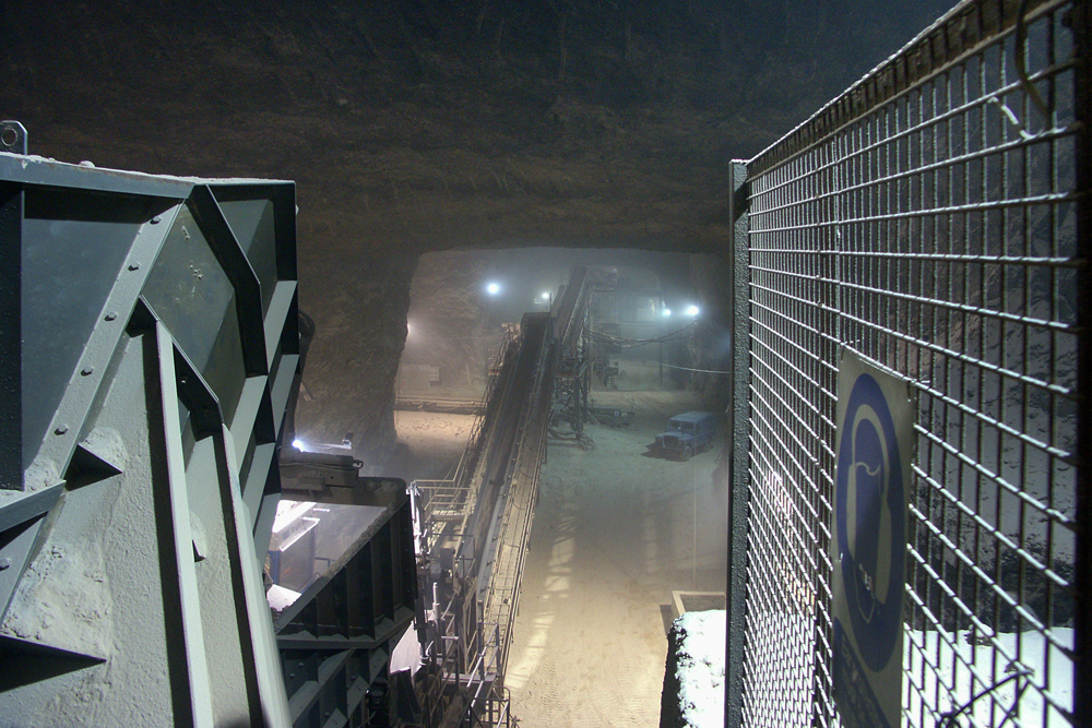
An average Panamax dry bulk-carrier can carry approximately 55,000 tons (110 million pounds) of salt. The disaggregated assembly line of machines that began in the Atacama Desert resumes when the salt ship holds open in port. A fleet of bulldozers or front-end loaders is lowered inside by crane. The machines work ceaselessly to push the salt from the edges of the hold into the center, within the crane’s reach. A crane’s clamshell bucket holds about 30 tons of salt, and the cranes execute approximately 1,833 swings to extract the Chilean salt. An experienced crane operator can complete a full swing and dump cycle in approximately one minute.
The unloading of the ship and the construction of the land-side pile is a carefully timed dance of machines, their motions synchronized in a sequence that transports the salt from a pile in the ship’s hold, to a drop-pile at the water’s edge, to a stock-pile further inland, each shaped by the particular qualities of the machines.
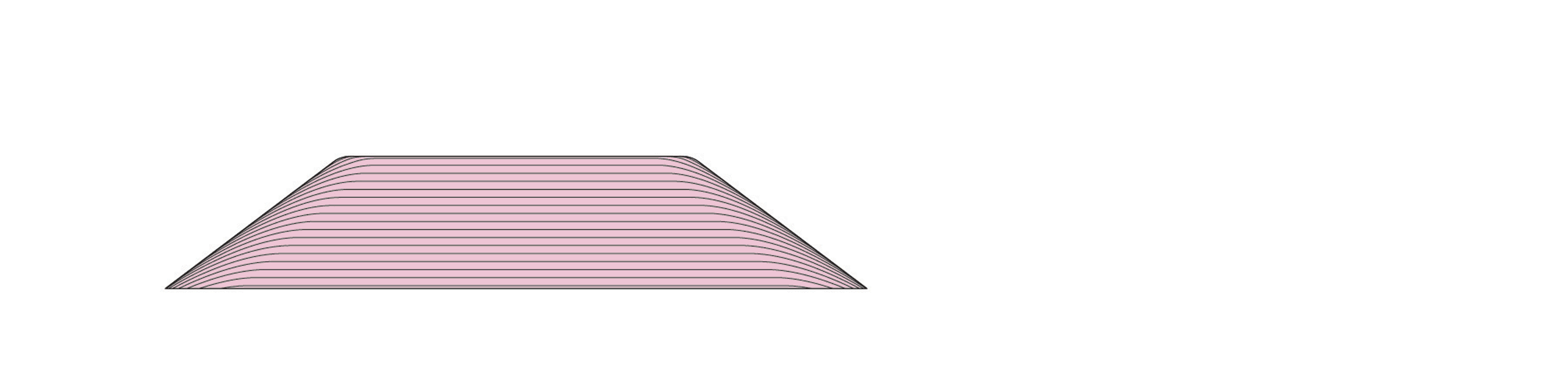
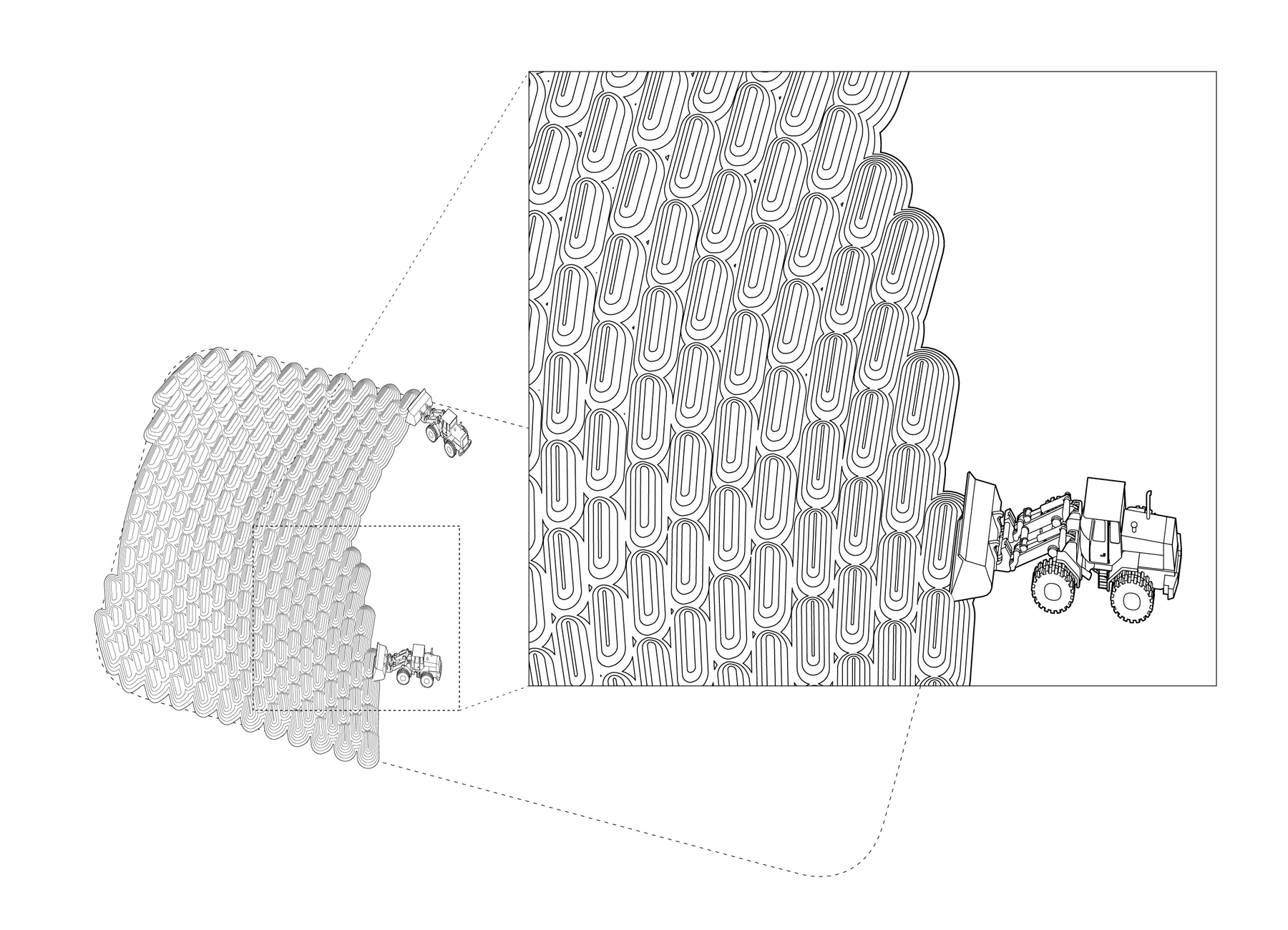
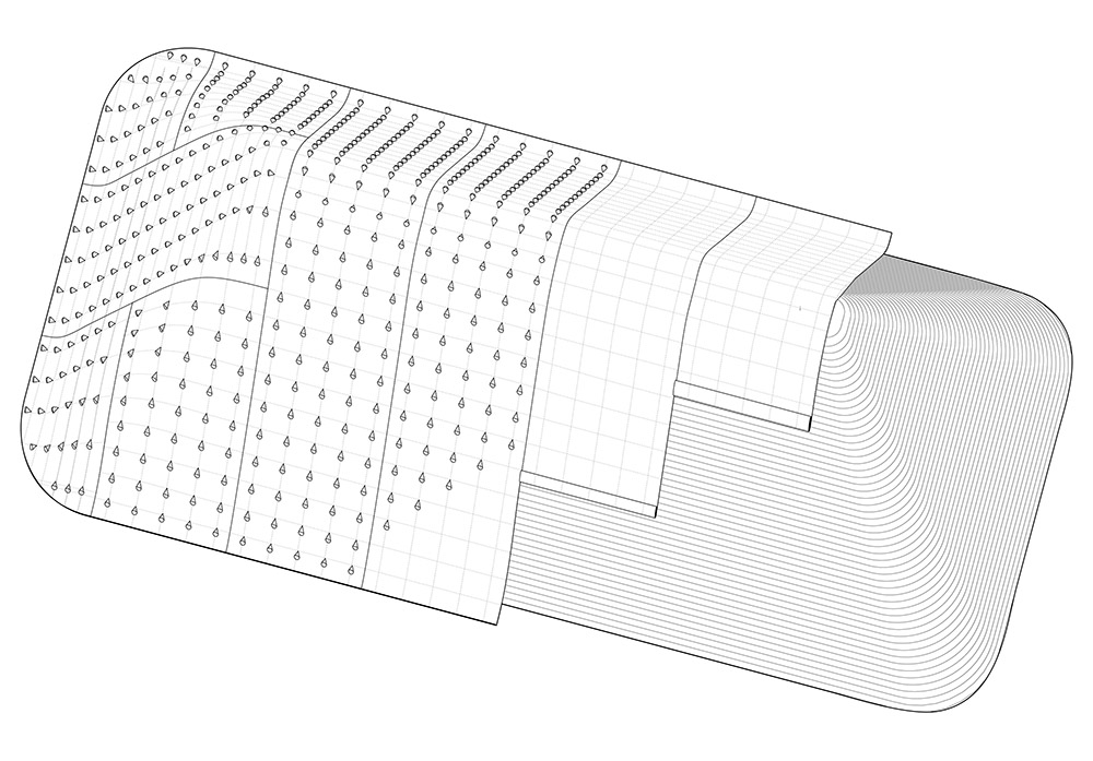
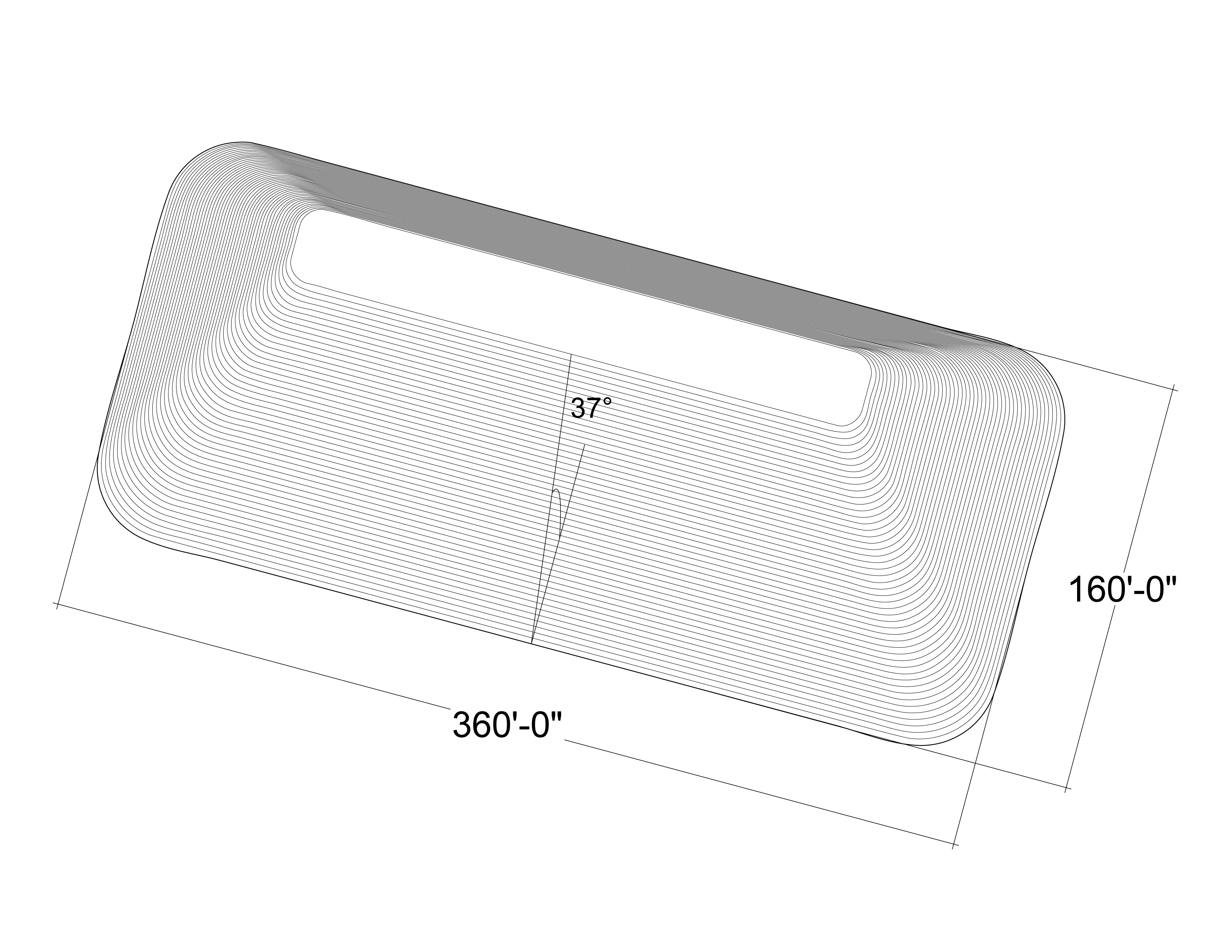
Any pile is itself an aggregation of numerous piles, each deposited atop another. The loaders deposit bucket loads of salt, ten tons at a time, in radiating patterns that eventually form ramps for driving machines to build the pile higher. Through this accumulative process, the ramps become embedded within the pile as layers of constructed strata.
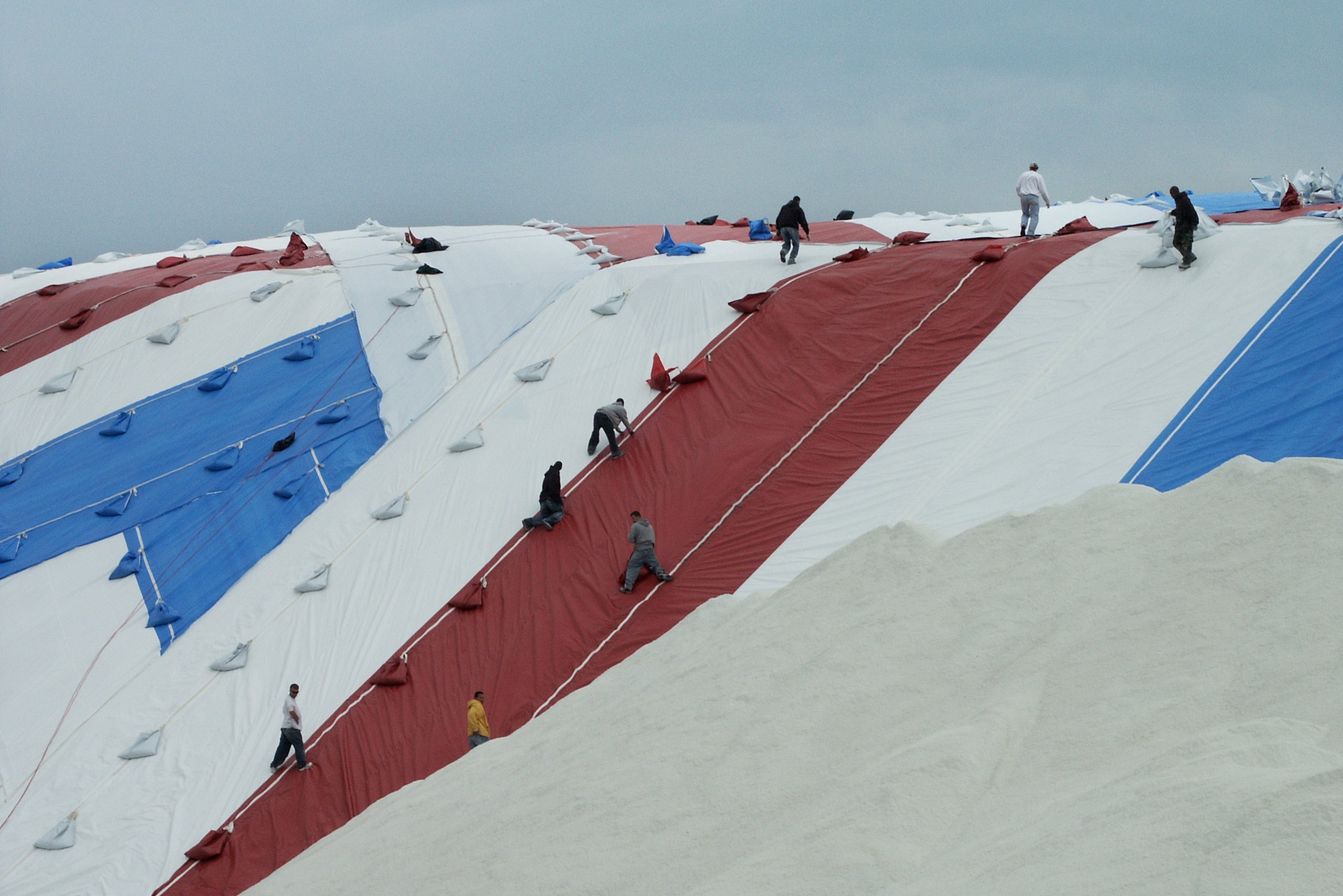
As the pile is built, it is sculpted in anticipation of a tailored covering that will protect the salt from exposure to rain. The pile is shaped to shed water along its sides and off its gently pitched top.
The pile is then swathed with tarps like a custom-fitted quilt. Vinyl panels, 60 by 240 feet, are hoisted in rolled bundles by cranes to the top. Teams of workers unfurl the tarps and rappel down the sides with hand-held sewing machines, stitching together the panels for a tight fit. Bags of salt are sewn into the cover to weigh it down against the wind.
Depending on moisture content, compression, and crystal size, a cubic yard of salt weighs about 1.08 tons (2,160 pounds). Its angle of repose, the natural slope of a granular material when piled, is 37 degrees. A salt pile covering the area of a football field (300 feet by 160 feet) would be 50 feet tall and weigh about 55,000 tons (110 million pounds).
A simple volumetric definition, however, belies the hidden structure of the Staten Island salt pile. It is not static, but constantly changing as a result of economic, infrastructural, and meteorological influences.
When road surfaces threaten to freeze, highway and municipal works departments spread salt from small, locally distributed piles. These are replenished from a central facility, which is replenished by global mining networks.
This is the essential function of the Staten Island salt dock: to translate the scale and operations of globe-traveling ships and their cargos into smaller packages for local distribution. The pile is a stopgap measure scaled to the demands of the region. In the dense urban environment of New York City, there is only room to store a small percentage of the salt typically demanded within one season, so the salt facility anticipates “cycling” the dock multiple times over the winter.
As ice demands, the pile’s cover is peeled back to expose the salt. While the pile was constructed as a series of ramps, it is broken down in faces. The front-end loaders that built the pile now carve into its base, causing the salt above to drop to the ground for scooping into trucks and delivery to satellite piles throughout the region. And as the faces are carved away, the embedded ramps are revealed again as strata, evidence of varied global geography in the constructed salt cliffs.
The bridges that stitch the boroughs of New York City together limit the weight of trucks to 80,000 pounds (40 tons), 17 tons of which is the typical weight of the truck itself. Three scoops from the front-end loaders, and the trucks are loaded, weighed, and dispatched into the city and beyond in cargos of the net difference, 23 tons.
···
Back in the harbor — the ultimate landscape of translation between the globe and the city, ecology, and industry — the ship awaits its return to the open sea. Farther north in this brackish estuary, the “salt front,” the ever-fluctuating boundary between salt water of the sea and the fresh water of the Hudson Valley, shifts somewhere between the Tappan Zee Bridge and Poughkeepsie.
Such translations — when the ocean becomes a river, when the open sea becomes an infrastructural channel, when a natural process becomes industrialized — are impossible to pinpoint in exact time or place, but the operations of the harbor make them legible.
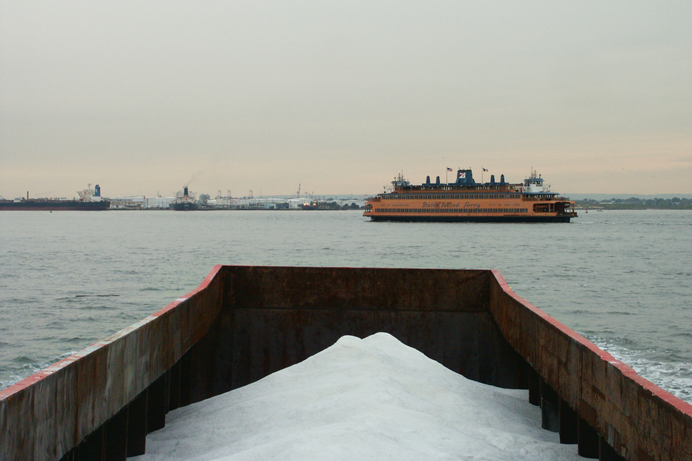
This lightering barge carries 3,000 tons of salt harvested from evaporation lagoons in Mexico through the Kill Van Kull, about to cross paths with the Staten Island Ferry. Inside the barge sits the evaporated Pacific Ocean. Outside is the Atlantic Ocean. They are separated by a thin shell of steel. Within a few hours the salt will be built into the salt pile on the shore of Staten Island, and within months it will be on the streets of New York — destined to enter the ocean once again.
“We think it’s just a lot more exciting to be playing basketball as an oil tanker passes by within feet,” says Marie on Landing Studio’s interest in melding industrial landscapes with public space. Learn more about their architectural practice in a 2015 interview and lecture delivered upon their receipt of The Architectural League Prize:
The views expressed here are those of the authors only and do not reflect the position of The Architectural League of New York.


Comments