
Series
City of Cycling
A look at how pedal-pushing can redefine urban space. Guest-edited by SLO Architecture.
In This SeriesWe are celebrating 15 years — and counting — of stories that are deeply researched and deeply felt, that build a historical record of what the city has been.
Paul Gertner is chair of the Harbor Ring Committee at Transportation Alternatives (TA), a not-for-profit organization founded in 1973, whose stated mission is “to reclaim New York City’s streets from the automobile and to promote bicycling, walking, and public transit.” With David Paco Abraham, Laura Barlament, Mike Lydon, and David Wenger, Gertner serves on a volunteer steering committee for TA’s Harbor Ring campaign, an initiative to link the waterfronts of southwest Brooklyn, Staten Island and New Jersey into a single, bikeable, 55-mile loop. Currently, the principal obstacle in completing the ring is bike access to the Verrazano-Narrows Bridge, which connects Brooklyn and Staten Island. We speak to Gertner about the advantages of a harbor network and the current challenges in obtaining bridge access.
Tell us how the Harbor Ring came to be. Who got it started and why?
I’ve been on the Advisory Council of Transportation Alternatives (TA) since 2008, and I like to get involved with their initiatives. In 2011, I became interested in the Verrazano-Narrows Bridge, and Paul Steely White, the Executive Director of TA, told me that there were three other people who wanted to advocate for a bike lane on the bridge. So we started meeting. I began looking into the history of the bicycle access question, and saw that there had been a demand for it ever since the day the bridge was first opened. I realized that there was a disconnect between the idea of a cars-only crossing and the reality evolving in the region. Bikes are taking off all over the city. We now have waterfront development all along the harbor with parks and bike paths. It’s a whole rebirth, the “new New York.” And the powers that be have repeatedly rejected bike access on the bridge.
We started thinking about how we could recast the idea of a shared-use path on the bridge. I’m an urban and regional planner by training, but I’ve been in the family hardware business, and so I thought, “We have to take a marketing approach to repackage Verrazano access.” It’s the missing link in the Harbor Ring. We became the Harbor Ring Committee.
Can you describe the Harbor Ring?
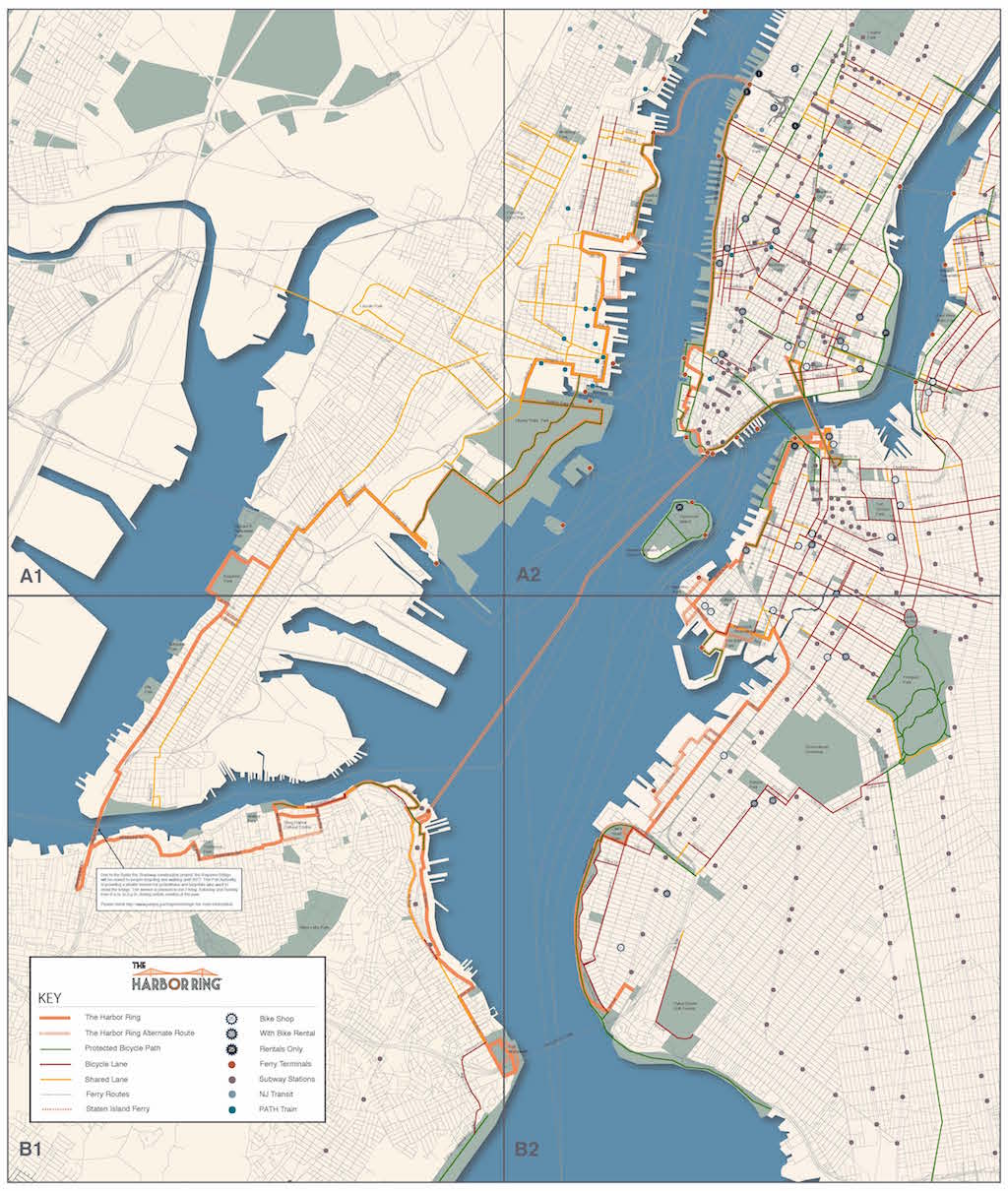
The bike and pedestrian network has grown a lot over the last ten years, but it’s still discontinuous. You have the Hudson River Waterfront Walkway in New Jersey, the Hudson River Greenway along the waterfront in Manhattan, and greenways in Brooklyn and Queens. We realized that you can just connect them all.
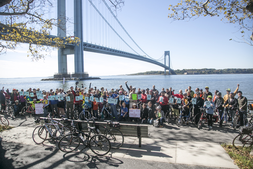
The idea of the pathway trajectory is that we are not “pathway gods.” We want to put the mapped lines out there and have people comment on them. We published a map and it got into a lot of newspapers. The press coverage started, then we held two really good rallies for the Verrazano Bridge cycling and walking access. The Harbor Ring started to enter public vocabulary and thought.
Who has been involved in the Harbor Ring? Is New Jersey engaged, or is interest found mostly here in New York City?
Mostly New York City. We definitely have support from Staten Island and Bay Ridge politicians. Hoboken and Jersey City are also both very pro-bike. They both have their own bike share programs and both have very pro-bike mayors. Most of our emphasis has been on the Verrazano access itself, which remains elusive.
What do you think is great about the Harbor Ring? What would local New Yorkers and Jerseyites gain from it?
TA rightfully got involved in pushing for street safety, and now there’s a mini-pivot back to infrastructural links. There’s such a need for continuity. There’s a real need to tie things together to have some real infrastructure where the bike paths are separated.
Continuity is important. A path through dense traffic has to give the feeling that you can move with fluidity.
The more dangerous stretches are where striped bike lanes drop out in the middle of high-traffic blocks.
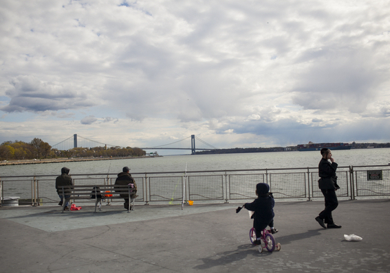
The reason most people don’t bike is that they don’t feel safe. They need to feel safer. They’ll bike in Prospect Park but not in Manhattan. In the 1920s and ‘30s they put out regional maps of highway networks years before they were built. Moses also made these maps, but nobody has ever done that kind of regional master planning for cycling. The so-called regional plans for cycling are mostly narratives for local governments to think about cyclists and pedestrians. Our Harbor Ring map was made by just five people on their bikes. The funny thing is you could map a route on a bike by testing it on the street and then say this is the Harbor Ring map. It’s a no-brainer that it would be around the harbor because that’s where the people are — the developments, the tourists, the highways, the waterfront. Following the water is really functional from a transportation standpoint.
The idea of the Harbor Ring seems to be to bring the greater New York harbor region and the city’s long local waterway edges together in the mind. I know someone who works on the Upper West Side who bikes every day from his home in Bay Ridge and leaves his car at home. He would love the Harbor Ring.
I think the places along the Ring should be networked in a new way. Running a bike path around the harbor is an obvious beginning. There should be a regional planning summit, just as they laid out the highways, for a regional pathway network all planned out in advance. The beauty of that is, once people decide where the route should go, people can start to use it and test it before the infrastructure is built. Then it can get signed, striped and eventually turned into a bikeway. Someone needs to come along with the vision. Looking beyond New York City, you’d have to envision the Harbor Ring as a regional network, encompassing New York and New Jersey.
What would happen if someone went on the Verrazano by bike now?
They would get arrested.
Even though bicycles are technically considered vehicles with the same rights as cars on local streets, the Verrazano is part of a limited-access highway system.
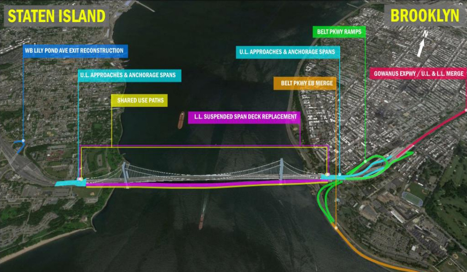
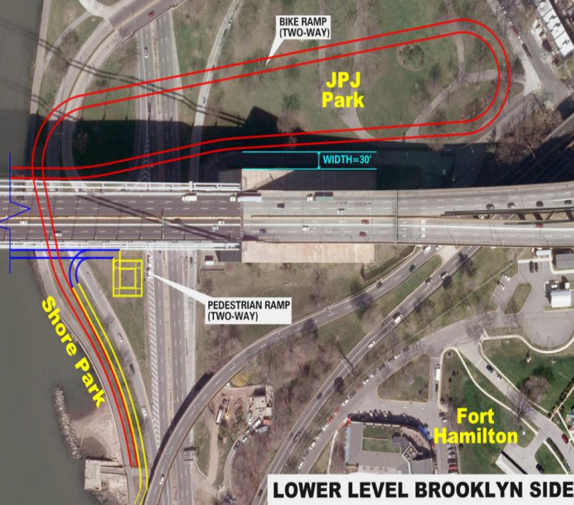
The Metropolitan Transit Authority (MTA) owns the bridge. They famously march to the beat of their own drummer. There’s very little public oversight. Our committee has tried to have dialogue with them. At one point they said they were thinking about studying the Verrazano access, and we found out through a FOIA request that they had issued a Request for Proposals and signed a contract with Parsons Brinkerhoff (PB). Back in 1997, the Department of City Planning had commissioned Amman and Whitney (A&W), the original designers of the bridge, to do a complete study of the pathway, and they prepared a very detailed report with options for bike and pedestrian paths on the upper and lower roadways that would cost $25 million, which inflates to $50 million today. So we suggested to the MTA that they use the A&W plan that they already had. But we were told that, because of September 11th, requirements had changed. A&W’s favored option was to hang the paths off the upper level. You’d have nicer views. But that wouldn’t be possible anymore, because the upper level is where the suspension cables are located.
Ultimately, the PB plan essentially followed the A&W lower-level option, except for the Brooklyn approach. Whereas A&W started the Brooklyn side on-ramp at 94th Street, where the road was already following a high elevation, PB decided they needed to start the bike ramp down at the waterfront greenway, at a much lower elevation, requiring much more infrastructure to reach bridge height. And that is in large part what drove up the cost to $300 or 400 million.
Why did they want to do that?
They said it was because they wanted it to hook up to the waterfront greenway. But if you’re doing a design project, you don’t just unilaterally come up with a program, you’re supposed to have input from the public to arrive at the best options. You can have workshops and ask the public where the bike lane bridge connections should go, whether down along the water, or closer inland, up along the bridge approaches. And there’s a huge difference in the cost. As far as we can tell, PB started with the assumption that it had to start at the waterfront greenway, and then proceeded to design this huge ramp system. It’s a very large piece of infrastructure.
Last spring, I asked a recently retired bridge engineer to review the A&W and PB plans. He said the A&W plan is still viable, and came up with an estimate of around $50 million, coming to the same estimate as the A&W plan, with inflation. We then sent MTA a letter about this. In the letter, we said that we understood why they considered the direct greenway connection to the bridge, but that we wanted to make sure they were looking at the A&W plan, showing the Bay-Ridge-Street approach. MTA never got back to us. Meanwhile, last August, we also consulted a senior transportation engineer. He said that, in his view, both Brooklyn approach-plans were well-designed, but that the A&W Fourth Avenue/94th Street approach proposal was much more cost-effective, much better connected to the subway, and that there could easily be a five block on-street bike lane that could connect back to the shoreline greenway from the bridge along Fourth Avenue.
It sounds to me, from what you’ve described, that the unilateral choice of the waterfront-greenway-connected approach and the total cost of $400 million may have been made to dissuade the possibility of a shared-use path on the bridge in the first place. When one sees something this expensive proposed, it seems to suggest, “better not to do it at all.”
You’re right, it doesn’t make sense, because there’s another viable shared-use path plan sitting right in front of them at a fraction of the cost.
It sounds like maybe this project could go through a more engaged public process. Does the Mayor have influence in talking to the Governor? To reach MTA from its leadership?
MTA is mostly controlled by the Governor. He appoints people to the MTA board. We’ve tried to get Cuomo interested in the project, writing coalition letters and petitions.
Cuomo is currently involved in visioning and executing a lot of large-scale signature infrastructural work, including the new Tappan Zee Bridge, which incorporates a shared-use path with viewing platforms to enjoy the Hudson Valley. You would think he’d be interested in this project to add shared-use access to the Verrazano, as a part of the bigger picture.
If it were $50 million, then, maybe, yes. But $400 million is a lot of money.
The first day the Verrazano opened — it was covered in the New York Times — teenagers were protesting that there was no pathway. This was in 1964. From the very first day, people attempted to march on the bridge. Moses’s public excuse for omitting pathway access was the cost, suicides, and the fact that people weren’t using the Triborough pathway.
That Triborough pathway feels really disconnected from everything. You get the sense that you’re in the middle of a wasteland. It’s even a little menacing.
The Triborough Bridge is very high, and the pathway railing runs low in sections. I have friends who are too afraid to ride it in parts.
The Harbor Ring, when it is finally complete, will be a great way to bring Staten Island into the rest of the city, as it sometimes feels at a remove.
The North Shore of Staten Island is attracting more and more attention. It’s a beautiful shoreline. There’s a real energy there. People have said it’s the next Greenpoint or Red Hook. It’s the next waterfront area to get a chain of parks and see some positive development.
It seems like you need to have more than one way off of Staten Island. The ferry is not enough.
During and right after Hurricane Sandy, there was no way onto or off the island. You didn’t have gas, and there was flotsam in the water, so for a time the ferry was shut down, and you couldn’t cycle over the bridge. The Rudin Center issued a report right after Sandy saying that emergency evacuation was a real reason for a pathway on the Verrazano.
What are your next steps?
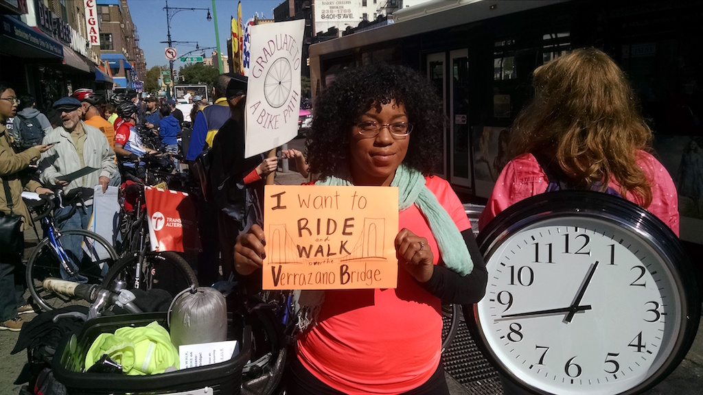
We’ve held big rallies — on Staten Island in 2014, in Brooklyn in 2015 — and now we’re planning another for Brooklyn on October 15th. But we can’t just keep having rallies. We’re currently working on strategies for broader public outreach — we have to make the idea real.
The views expressed here are those of the authors only and do not reflect the position of The Architectural League of New York.
A look at how pedal-pushing can redefine urban space. Guest-edited by SLO Architecture.
In This Series