We are celebrating 15 years — and counting — of stories that are deeply researched and deeply felt, that build a historical record of what the city has been.
We are celebrating 15 years — and counting — of stories that are deeply researched and deeply felt, that build a historical record of what the city has been.
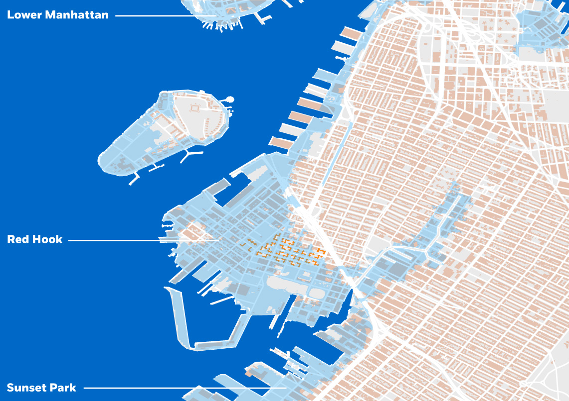
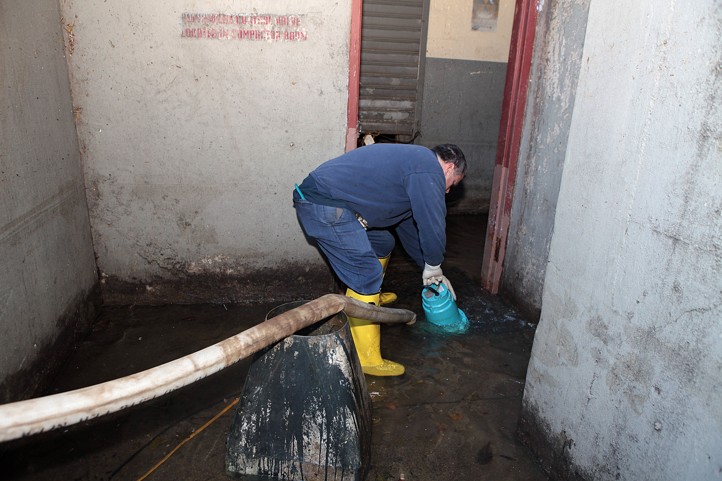
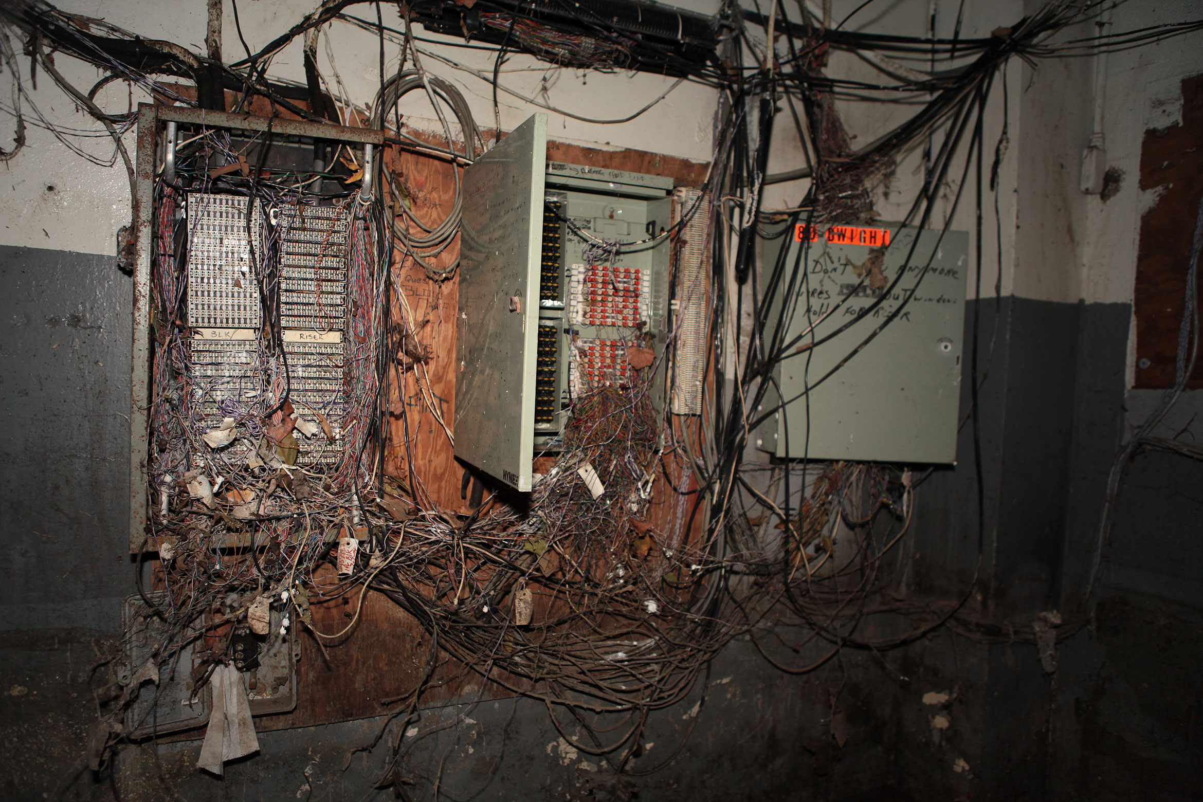
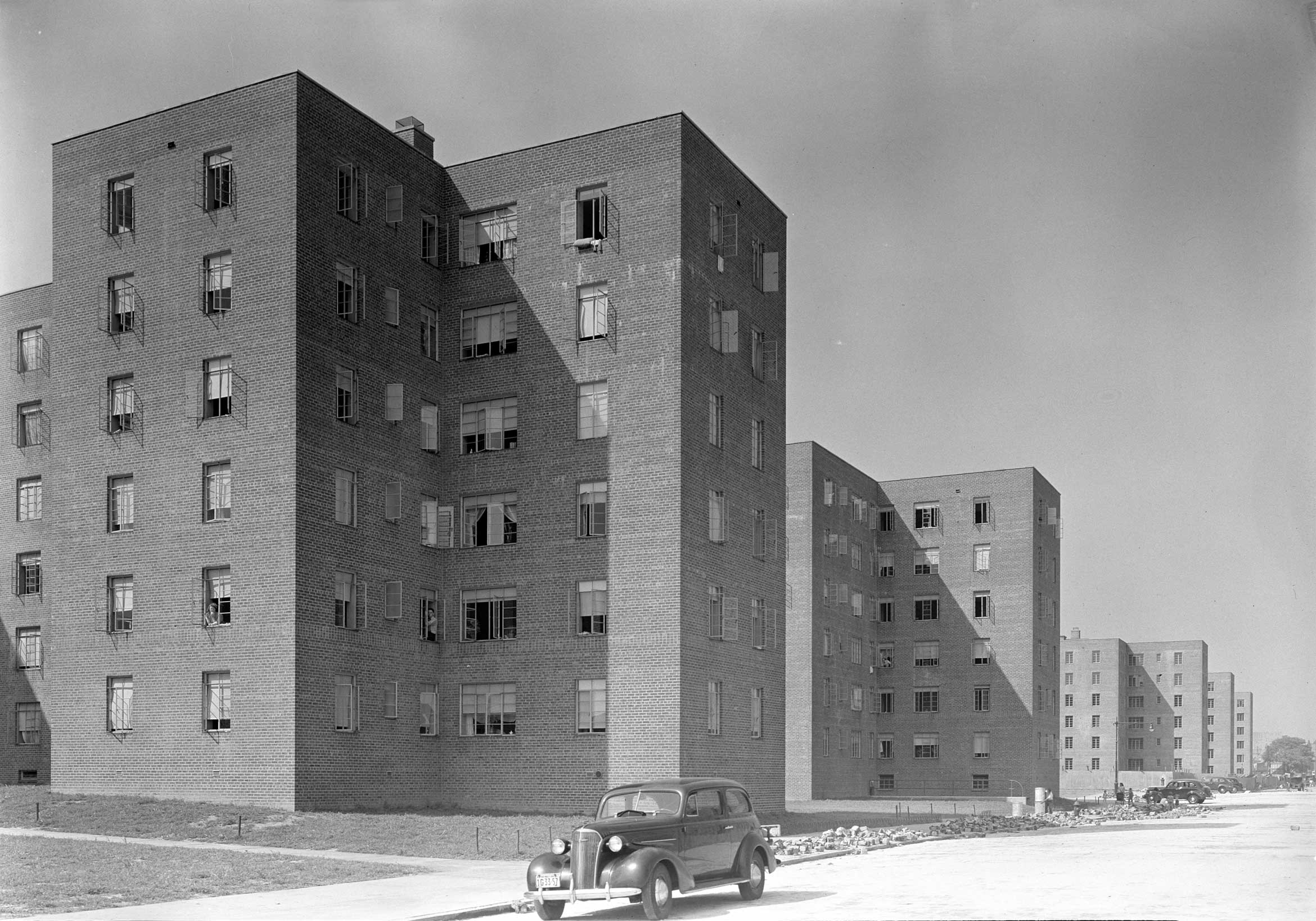
Nearly six years after Hurricane Sandy struck New York City, the rubble left in the catastrophic storm’s wake has been cleared away, but the road to recovery is still plenty long: rebuilding the L train’s East River tunnel, raising houses in the outer boroughs to safer heights, reinforcing the coast against future disasters. One overdue project is shoring up the city’s public housing. Sandy inundated ten percent of NYCHA’s developments, home to 80,000 New Yorkers. The storm hit Red Hook Houses, Brooklyn’s largest NYCHA campus, especially hard. Red Hook Houses was built mainly in the 1930s on low-lying and low-valued land near an active port; in 2012, most of the roughly 6,000 residents were left without electricity, heat, and hot water for more than two weeks after the aging basements were flooded and critical equipment destroyed. Post-Sandy, the development has been patched through ad hoc recovery efforts, but today boilers intended to be temporary are still running.
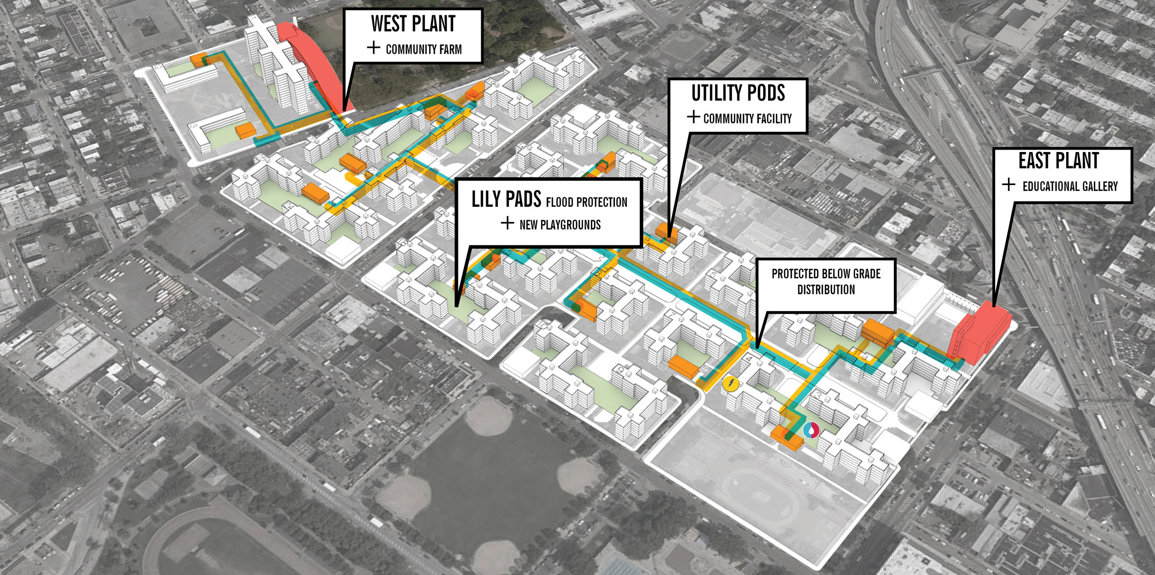
As part of the nearly $3 billion grant from the Federal Emergency Management Agency (FEMA) to the New York City Housing Authority (NYCHA), the Red Hook Houses are receiving an infrastructural overhaul. Beginning with roof repairs now underway — leaks and mold are persistent problems — approximately $550 million is earmarked to repair and fortify the campus of 28 residential buildings. A caveat: FEMA funds can be used only for Sandy damage and resilience efforts; while NYCHA collectively holds the title of worst in the city for housing conditions and boasts $32 billion in unmet capital needs, the building interiors cannot be touched. But the design team, led by Kohn Pedersen Fox (KPF) with OLIN landscape architects, hopes their plans for two new power plants, 15 utility “pods” to distribute energy, courtyard “lily pads,” a hardy landscape, and new resident amenities will provide something beyond disaster relief. Hana Kassem of KPF and Richard Roark of OLIN fill us in on their plans and how Red Hook will weather future storms.
When and how did both of you come to work at the Red Hook Houses?
We at KPF had done a few studies for NYCHA on various housing developments throughout the city. Those were not specifically about Sandy and its repercussions, but more about tying those developments into the city, looking at the street fronts and infill possibilities. That’s how we got to know NYCHA and they got to know us. When this FEMA-funded project came up for Red Hook Houses, we teamed up with OLIN and Arup to apply and we got the job.
At the beginning it was quite overwhelming, in terms of the scale and the scope. We looked at several scenarios: One was sort of pie in the sky, one was a bare minimum response to the repercussions of Sandy, and one was in-between. I think we ended up somewhere between the medium and the minimum, which we’re very happy with and think is appropriate.
This was an amazing opportunity to work on something with direct federal funding, and not just working in a build-it-back mode but aiming for adaptive, thoughtful design. Though this process has gone on three years now and that seems like a long time in terms of getting to a buildable project, in the scope of recovery this project is actually one of the fastest.
What happened to the Red Hook Houses after Sandy hit? What were some of the lingering problems when you arrived there in 2015?
When we arrived three years later there were still emergency generators, around 15 of them, hooked up to the buildings. They were meant to be temporary, but the basements were severely flooded, including all the mechanical equipment that was down there — generators, et cetera. This was really the number one issue that we had to deal with.
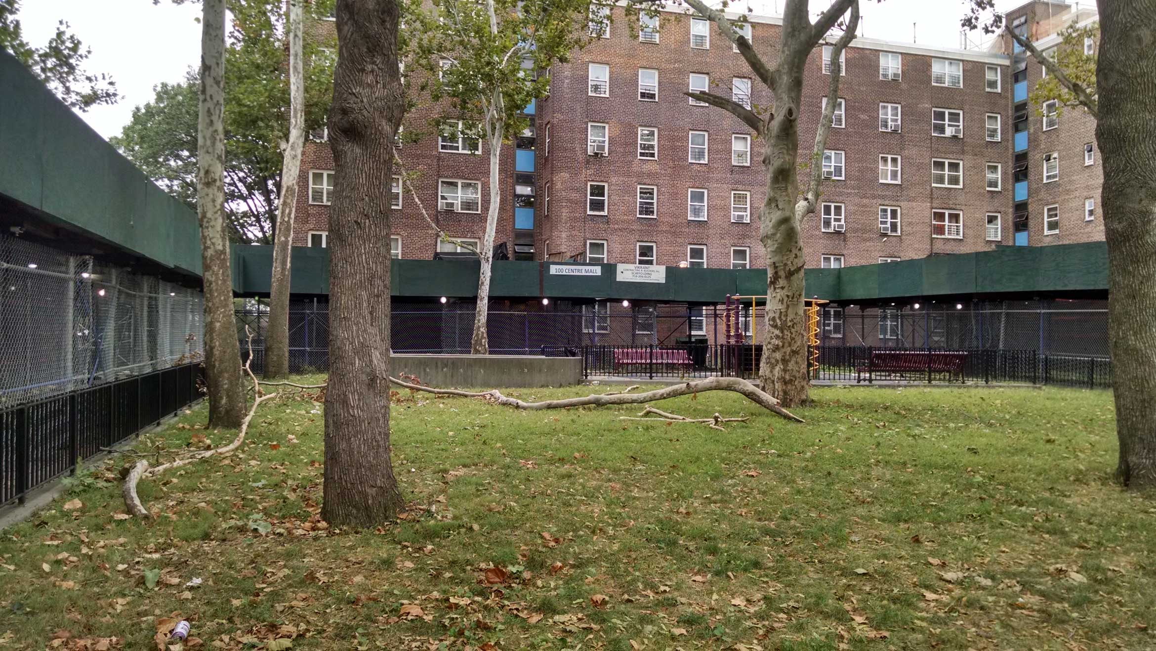
There was a lot of damage in the landscape. One of the most beautiful aspects of the Red Hook Houses are these mature trees that are very much part of the public spaces; some of them were knocked over during Sandy and some of them eventually deteriorated from salt damage. Even during our design process, some of them were deemed too dangerous to leave in place.
Then there was some damage to some of the entrances and to portions of the façades at the base.
Three quarters of the buildings, which were built between the late ‘30s and the mid ‘50s, were flooded because the sewer systems had nowhere to go: the water rise backed everything up. The sewer overflow, in addition to the saltiness of the water generally, meant the grounds were just hit pretty hard.
Red Hook Houses is a fascinating place because it has the highest ratio of green space to built space in this part of Brooklyn, and yet at the same time the green space is incredibly underutilized because there’s not a lot of staff to take care of NYCHA properties. A lot of the green spaces are fenced off. Even the play equipment is about 25 years old and not code compliant.
One thing that we noticed when we were first visiting the site is that there are very few places to gather outdoors. A typical thing in NYCHA developments is the black fence that surrounds the green spaces. Seventy percent of the green spaces are not utilized, and are very minimally maintained, so we really worked with the community in terms of culture change to try to open up the green spaces and transform the public realm.
Which agency or agencies defined your scope? And what was that scope?
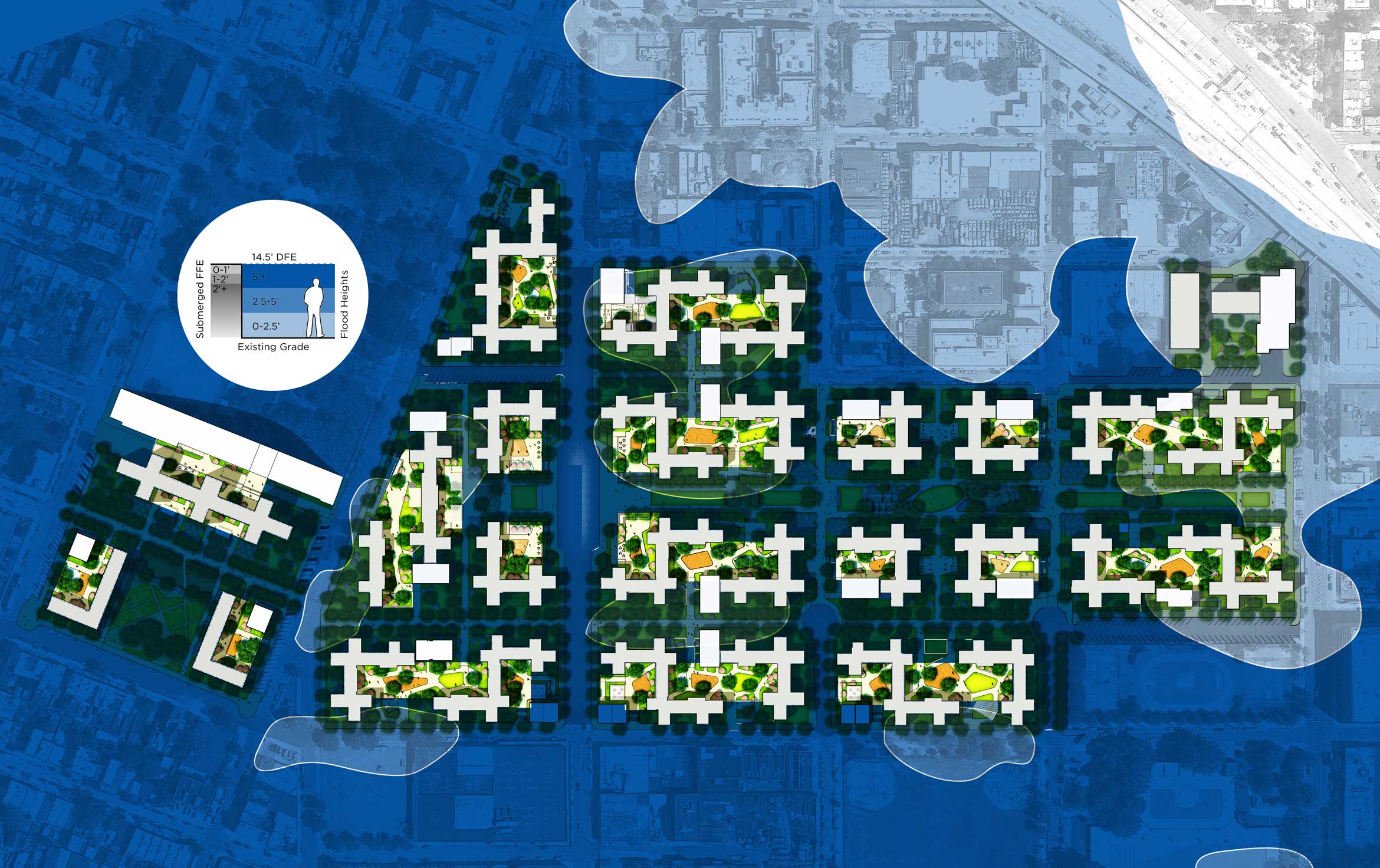
Well, FEMA decides what it will and will not fund — so anything not related to a climatic event, which was Sandy in this case, is not going to be funded by FEMA. So that was the limit of our scope. Our intervention was infrastructural: We created two power plants that are elevated and will provide back-up, emergency power and steam, and then these mechanical pods for distribution. We also designed, together with OLIN, a flood protection system: We’ve created landscaped, stepped terraces between buildings, which we call the “lily pads,” that provide dry areas when you come out of the lobbies. Those will have new playgrounds. Almost all of the basements which were flooded have been vacated; five buildings will still have some offices in the basement, and those spaces will be dry floodproofed. Everything else will be wet floodproofed. Finally, there are repairs to the roofs already underway.
There were a lot of things that simply needed to be updated. We really had to look at how to put the parts together in a way that made more sense than before, and that would hopefully help with the adaptation to climate change.
Throughout the majority of the development what we were accounting for was sea level rise plus the current FEMA flood elevation — which meant adding 30 inches to everything. We wanted to get the mechanical systems to 14.5 feet above sea level and the courtyards above 12 feet. Just about every courtyard had to come up. Lastly, there’s the redistribution system of the mechanical heat and power throughout the development. We’re running conduits underground between all the buildings and adding those new building additions, the mechanical “pods.”
For every dollar that FEMA gave the project, we tried to wrap it with something the design could give back to the community, improve community space, add something that was missing without adding cost.
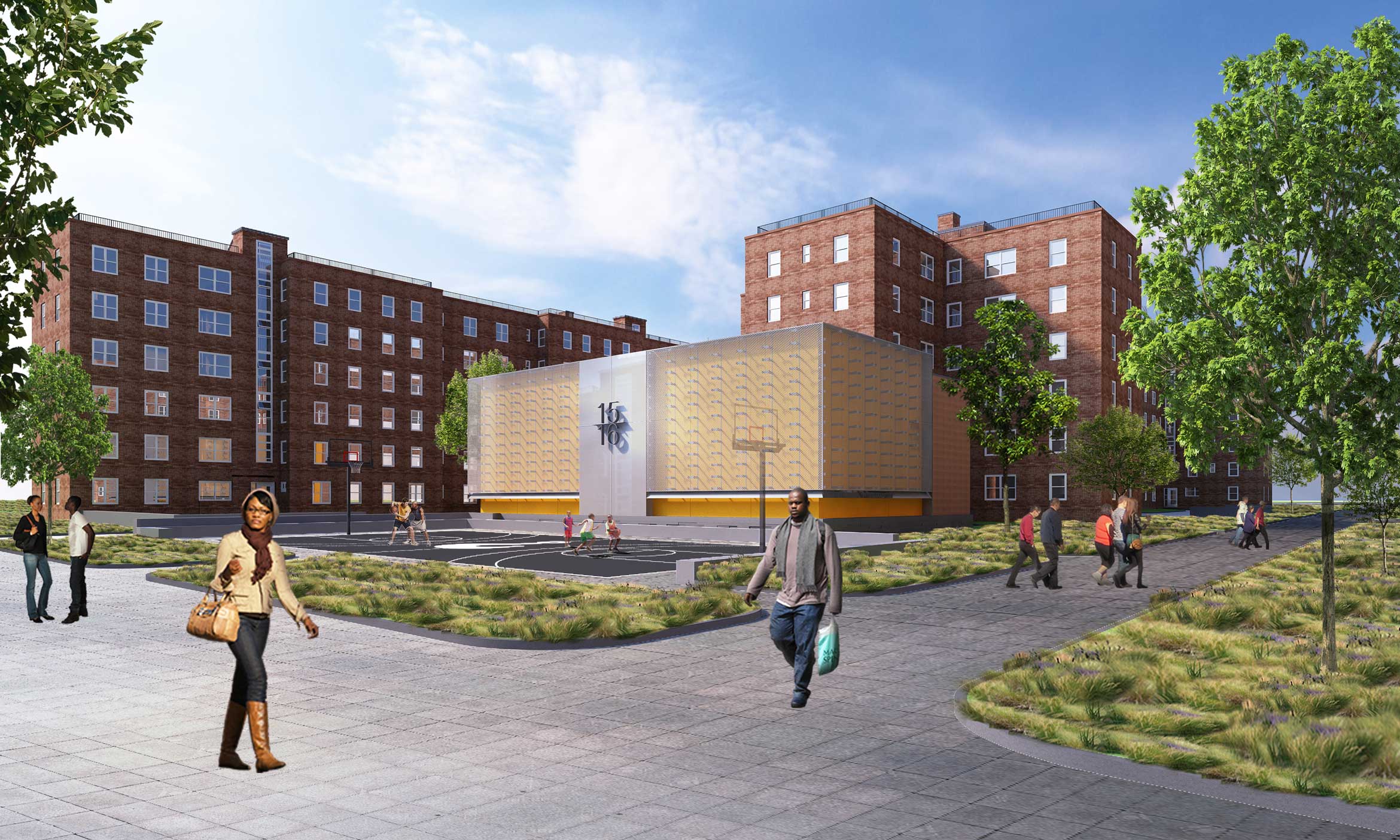
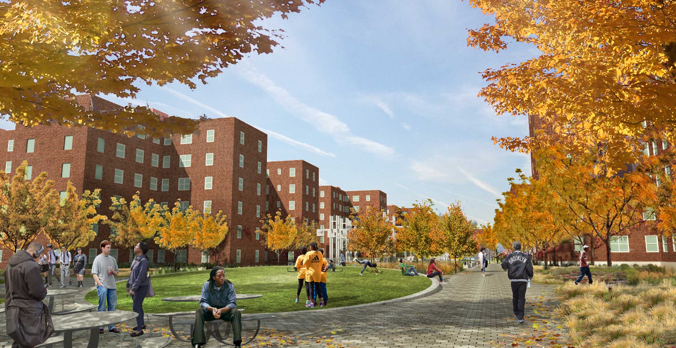
As you walk through the whole development, which has 28 buildings with about 6,000 to perhaps 8,000 inhabitants (we don’t know exactly), the buildings are all pretty much identical from east to west: five to six stories high, and identical in their materiality. The exception is the most recent taller building on the west side, which was built in the 1950s and is 14 stories high. It’s a very relentless architecture.
First and foremost, we tried to create a sense of identity and differentiation as you walk through. 15 mechanical pods throughout the site will distribute power and heat to the buildings. Color is a very affordable way to fabricate identity, so we tried to create some kind of differentiation in the project through a shift in the pods’ colors from east to west. They are also lit in such a way that they become like lanterns at night, and create space around them that may be perceived as safer.
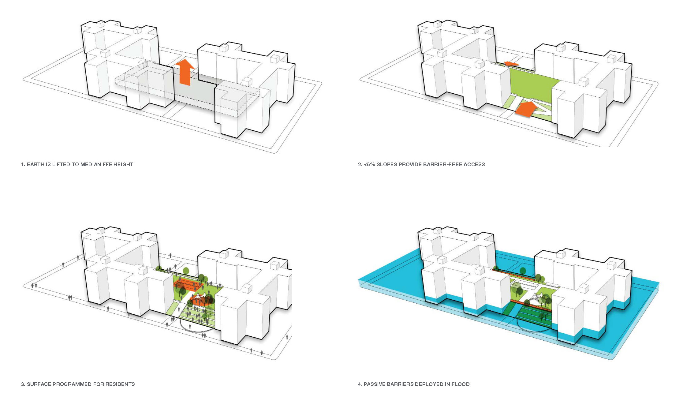
When we were looking at solutions for the flood protection, we looked at the menu of things that could get us to the height that we’re trying to reach. We wanted the landscape above 12 feet, and we realized the flood protection could actually make things worse, creating more isolation and more division. We really wanted to come up with something that wasn’t a wall, and that was lifting up the landscape in its entirety around the buildings.
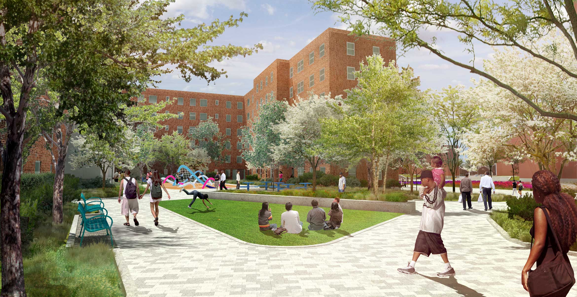
This actually makes good financial sense, too, because fill is cheaper than walls and with walls you wind up with the bathtub effect, where once water is on the inside it can’t get out. But the strategic earthworks program led to instead creating real courtyard spaces. These lily pads are a way to say to young children, “This is your yard to play in.” And it also helps us deal with another issue: access to the buildings. Right now, there’s a lot of stairs and ramps it’s really an awkward circulation. The lily pads create a way to get people up to the first floor without reliance on formal ramps. Instead, it’s a gentle slope up to this commons. It’s really gracious and natural; less utilitarian, more residential. That was the big win for our team, demonstrating that this project can be a restoration and also become something more.
Just by elevating this platform between three buildings, we’re grouping three entrances around one new courtyard. When you look at 28 total buildings, two or three buildings is a good scale to look at in terms of being able to identify with a group of people. Some of the lily pads have a more drastic grade change from the street up to the top of the lily pad, depending on the building’s elevation, but all contribute to animating the public realm and paths.
Right, so if you’re on Lorraine Street, at the southern end of the development, you’re at eight feet, while if you’re four blocks to the north up at 9th Street, you’re pretty close to the flood elevation level.
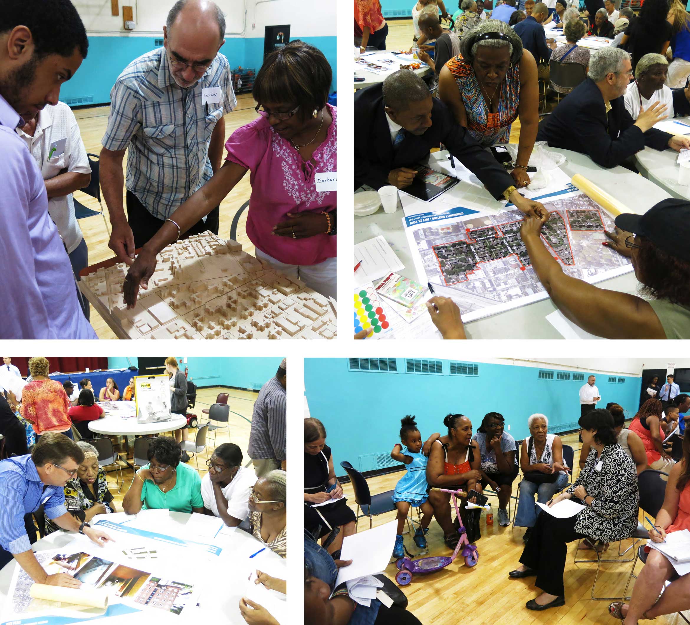
What sorts of conversations did you have with residents? Given the state of NYCHA generally — not just due to the storm — and especially since your scope of work didn’t involve the building interiors, I can imagine that there might have been some friction. Can you describe that engagement process?
That was a big learning moment for all of us. Our first community meeting was very difficult, on both sides. We went in thinking that we were going to be sharing these great design ideas that were going to improve the whole development. And from the residents’ point of view, that was not the problem. They were mainly concerned with their day-to-day problems, with the conditions of their apartments and other things that were well beyond our scope. We realized very quickly that our first task was to relay to the residents what our limitations were. So in all honesty, at the beginning, there was a certain sense of frustration from both sides because everybody’s reading in the papers about this large amount of money coming into Red Hook from FEMA. Once we delineated exactly what we could do and what we were bringing to the table, but also what was outside of our scope, I think things got a lot better.
There was still a lot of learning to be done. For example, when we would talk about creating public space and gathering space, some of the residents would see that as a negative. To us it’s a positive, but to them it was perhaps a threat to their safety — they were concerned with people who might take control of a certain territory because there was a new gathering place. We thought taking down the fences would be received very positively, but there were comments about the fact that now, somebody could walk up to a window on the first floor and look into the apartments. Or there were concerns with weeds growing, and who was going to take care of this landscape. From my point of view it was very enlightening, very enriching once it became a dialogue. And it was a back-and-forth, not assuming we know what we’re doing, trying to understand what works and doesn’t work. The residents made big steps in terms of opening up to the possibility of creating community spaces, creating landscape that was occupiable — things they were not used to, but which they could start to see as beneficial.
There’s a very large senior population and a lot of children as well. People were happy to see a consciousness about trying to make entrances to the buildings more accessible, and recognition that circulation can be problematic for people who aren’t fully mobile. It’s tough if you’re watching the kids and it’s not comfortable to sit around the playground, and if you have children with needs that aren’t addressed by a cookie-cutter playground. We were able to have work sessions with the kids to design the open space for ages one to 100, which hadn’t been thought through before.
But there is a lot of frustration because the extent of deferred maintenance in public housing — which is not just NYCHA’s problem, it’s a national problem — is extraordinary. And experiencing how long it takes for change and improvements to come has made residents very skeptical. When you come in and make changes, people really want to know what you’re doing, why you’re doing it, and whether it’s going to be okay when you walk away. It’s not just about capital improvements, it’s about the long-term care of open space and making sure that we’re designing it in a way that’s not creating another problem or creating something that won’t hold up. In designing the landscape, we knew that there’s not going to be a sudden new influx of campus maintenance workers. You have to understand how institutions are run on the budgets that they have. It’s an incredible challenge that we thought deeply about.
How do you navigate that, if there’s no additional money for maintenance but you think that some of the changes you’re making might require more maintenance than what the campus is currently getting?
For example, today, there are lawns — it’s the de facto, everywhere, even though residents can’t do anything with them since they’re fenced off. In terms of the landscape planting, you don’t want anything that’s not going to be super hardy, and you don’t want to make it so complex that somebody can’t tell the difference between what you intended to plant there and, say, an invasive pioneer species. So we kept the palette really simple. We chose trees and plants that after a two-year period can basically thrive on their own. They’re perennials instead of turf grass; we proposed some ornamental native grasses.
My challenge was, instead of trying to do something very interesting with 15 species, what can we do with four species? We were able to tell NYCHA, “Look, you don’t have to mow this like you have to mow turf. You can let this grow and it’s going to be stable and fine. And it’s going to have a fairly defined character so you know that if it’s fitting within these borders it’s doing what it’s supposed to.” Yet it does have some ecological context, like panicum. We wanted to do something about the place, something that actually has lower maintenance but more ecological value. But we didn’t do 20 different things. We were super economical.
I think for the buildings themselves we had the same frame of mind. The palette is quite reduced. These are low-maintenance, hardy materials — like for the pods, an expanded mesh façade with a pre-cast concrete base.
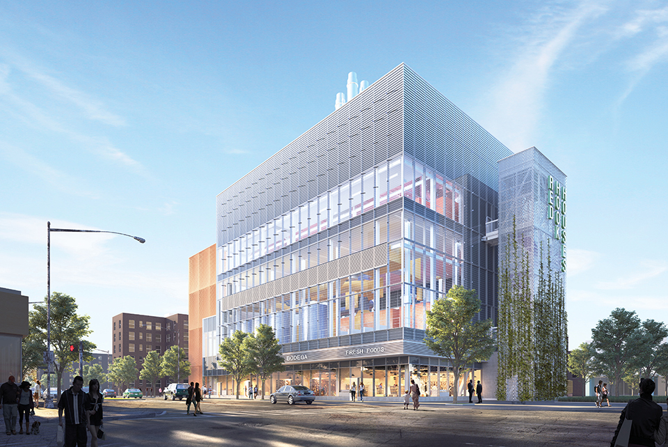
And we used a very limited amount of glass, only at the East Plant, where there is storefront retail and a desire to showcase the workings of the powerplant itself. The East Plant and the West Plant bookend the project, and then there are all the pods in between. The East Plant has retail at its base, which will be replaced with the same area of retail — a grocery store and hopefully that kind of convenience retail, which is very important for the residents, because it is a bit of a food desert. And then there will be a small window into one of the East Plant’s boiler rooms so that you could see what this building is about, as a way of educating the public about why this building exists. It acts as a beacon when it’s lit at night from inside, kind of a gateway to Red Hook as you’re coming from the F train and you cross under the BQE.
The other anchor point is the West Plant, which faces Coffey Park and is backed by the taller building, the fourteen-story building. It’s currently surface parking, which we will be reconfiguring. And there we’re looking at something much more landscape-related — we’ll have a green roof, and we’re looking at using some of the surfaces for a mural, so that it’s a lot more about the park and the community.
The Red Hook Houses is cut off from the surrounding low-lying residential and small businesses. It has its own urban design logic and relationship to the street. How do you think your interventions, like pulling out the fences and elevating the courtyards, might change the Red Hook Houses’ relationship to the rest of the neighborhood?
We are very much about opening up, knitting together, and cross-pollinating the community. If the architecture can create a platform for these kinds of interactions to take place and these exchanges to happen, between Red Hook residents and the neighborhood immediately surrounding it and beyond, I think that would be fantastic.
In some of the central spaces off the main green mall, we’ve proposed and shown in our renderings a weekend farmers’ market, which could be great in terms of cross-pollinating with the surrounding community and neighborhood, so that there is a reason for non-residents to walk through Red Hook Houses. That’s no architecture per se and it’s not something that FEMA is funding, but these are thoughts. I don’t think any of us on the design team believe in building walls and fences.
We don’t want to create more walls and edges or more of a sense of Otherness between the Red Hook campus and the residences and businesses around it. The challenge is trying to figure out how to make the Red Hook campus a place from the inside and give it those residential bones. It’s working with those tensions around fear of being pushed out. Many after Hurricane Sandy didn’t want to leave the residences, regardless of being out of heat or power, because there is such a shortage in affordable housing that they don’t want to lose it. So we’re dealing both with trying to make residents feel secure, and at the same time make the NYCHA neighborhood part of the greater neighborhood, so that everybody will see each other and know each other, and residents won’t be afraid of their open space.
If a Sandy-type event were to happen again once your project is fully implemented, what would it look like?
Because the mechanical systems are lifted up high, they are not going to experience the catastrophic failure that they did, when the water came into the basements and damaged the boiler rooms. Water won’t come through the building entries, because the lily pads will be protecting them. And instead of not being able to leave the buildings, people will have an area of refuge from the flood event because the lily pads will be above the flood stage. So that’s a pretty significant thing — residents could actually leave their houses, rescue workers could see them. It will make a big difference in terms of giving people immediate access to the outside and a place to coordinate activities, a place to get people together and check up on everyone. The buildings don’t really have any area for assembly inside. It’s a very different condition than they have today, where there’s no area of refuge from the waters.
What Richard’s referring to is that currently there’s not really a lobby, just a landing area in front of the elevators and stairs. There’s no place for people to get together and strategize or regroup. Also, from a mechanical point of view, the generators would kick in so the residents would have uninterrupted power throughout a storm. We don’t know what the next Sandy would look like. We don’t know if water’s going to come from the same side or what’s going to happen. That’s nature. But we think that we have designed the electrical systems and we’ve manipulated the landscape in such a way that the same problems will not happen.
This development is built on infill land, right by the water. What does enhancing this 40-acre campus look like in the context of an entire neighborhood that’s still vulnerable? How does this work in coordination with other climate change protections that are happening in Red Hook, or how does it impact the rest of the neighborhood that’s not getting these enhancements?
What we’re doing in Red Hook is not pushing water in any way to the surrounding neighborhood. It’s not going to make the situation worse should another Sandy happen. But one missing piece of the puzzle for me since the beginning of this project has been an understanding of our piece relative to other pieces of the resiliency effort. I feel there is a need for a round table of some sort that looks at this one piece of the puzzle and what happens when you add another piece and a third piece and a fourth piece. There’s an analysis that should take place: If and when these changes are implemented, what would the course of water be if it were to come from one side or another, or if it were to come from above, or it were to rise through the sewers? What would happen? There needs to be a big picture think tank of some sort that puts together all these projects and examines what happens at the macro scale, and how to allow for these unknowns.
All of our coastal cities are confronting this problem of exposure to risk. It’s going to be a process of intelligently aggregating strategies over time. I think that we can’t walk back our cities. On the East Coast, 75 percent of our power infrastructure is in a flood plain. It’s a massive rethink that has to be done piece by piece and really strategically.
We can’t lose the idea that cities belong to us all regardless of economic standing. Fortifying the Red Hook Houses says that we’re making a stand. But it’s not enough — it’s an example and it’s a model. I think what people don’t realize is that climate change will be a silent gentrifier in our cities if we don’t think in those terms. We need to be careful about how we build and construct so we don’t push the water toward others. We obviously looked if there was any displacement risk, but since the flooding was the result of sewers backing up, that’s not a risk here — we didn’t get a flood or wave event in Red Hook. But in the bigger picture thinking about making our infrastructure resilient and our neighborhoods inclusive, that’s what we have to plan for in the future.
There’s no silver bullet solution. The most important thing, I think, is that people should have information and education about that risk, about what to do in the short term and what the long-term opportunities can be. It’s not as black and white as, “Just don’t live in flood plains.” There’s a history of whole populations being confined to the flood plain; the Ninth Ward in New Orleans, for instance. And then once people make a community out of it, they’re told, “You’re living in the flood plain, you made a mistake.” You start to understand why there’s no trust. There are some places that we obviously shouldn’t build. But we’re not walking back from the culture and economic capacity of our cities, where we invested so much infrastructure, so much time, and so much community.
This post has been corrected to include up-to-date renderings.
The views expressed here are those of the authors only and do not reflect the position of The Architectural League of New York.