We are celebrating 15 years — and counting — of stories that are deeply researched and deeply felt, that build a historical record of what the city has been.
We are celebrating 15 years — and counting — of stories that are deeply researched and deeply felt, that build a historical record of what the city has been.
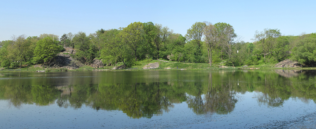
Starting this Friday, the north end of Central Park — a quieter, less-touristed space compared to the bustling pastures farther south — will host eight art installations over six weekends as part of Creative Time’s “Drifting in Daylight” project. Integral to these installations will be the landscape itself, a topography of rocky hills interspersed with rambling woods and the placid waters of the Harlem Meer.
As Marie Warsh, a landscape historian and Director of Preservation Planning for the Central Park Conservancy, describes here, this topography has long formed the basis of human interventions in the area: before Mannahatta became Manhattan, before prescient citizens called for setting aside the 843 acres on which Frederick Law Olmsted and Calvert Vaux pioneered the field of landscape architecture. Drawing on recent archaeological discoveries that shed new light on the history of the park’s Fort Landscape, Warsh reconsiders accounts of the park’s creation to pull apart layers of history, use, and intervention. In so doing, Warsh captures the complexity of designed spaces’ interaction with the places they inhabit and enriches our perception of what exactly we see when we scramble among the boulders near Harlem — nature, artifice, artifacts, or some inextricable mixture of all three. –J.T.
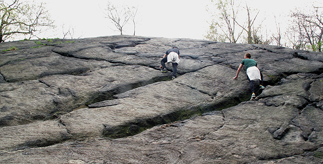
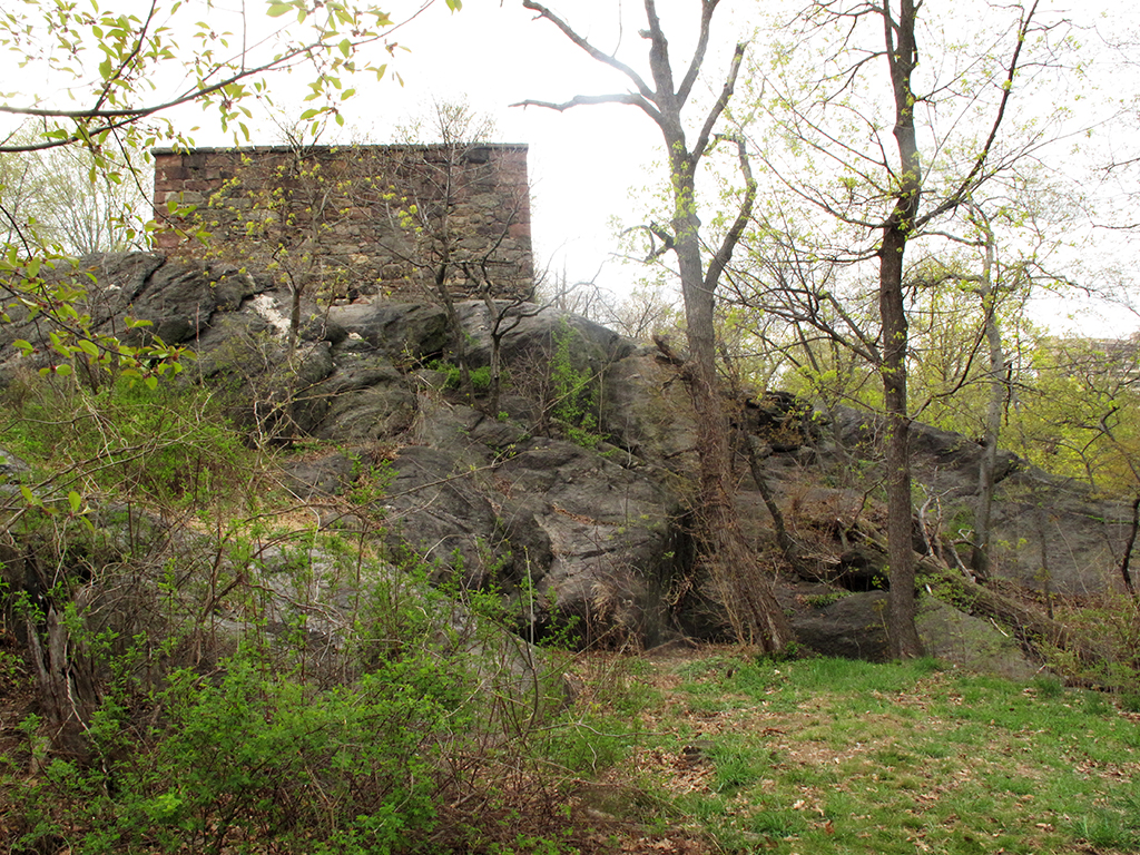
Wandering through the northern section of Central Park on a recent Sunday afternoon, I marveled at the numerous ways park visitors communed with rocks. Children and adults alike scrambled up steep slopes, couples sought out secluded perches among the crags, and sunbathers lay on outcrops finally warmed by the early spring sun. The park is one of the few remaining places in Manhattan where the island’s ancient schist bedrock makes an appearance, and in its rugged and sparsely built northern reaches, rocks dominate the landscape. To the northeast, near Fifth Avenue and 106th Street, they form a series of bluffs overlooking the waters of the Harlem Meer. Here, in what is known as the Fort Landscape, the views are striking, capturing the undulant park’s jarring transition back into urban regularity. The landscape’s name recalls a time when those bluffs were not a scenic experience but topography considered ideal for military defense.
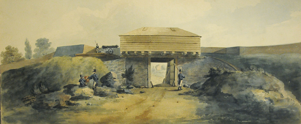
During the Revolutionary War and the War of 1812, British and American forces built fortifications on these heights, a little-known history that has endured primarily as a series of mysterious markings on early park maps. That is, until 2013, when archaeologists made some surprising discoveries as part of a Central Park Conservancy project to restore the deteriorated landscape. The investigations were conducted to ensure that planned construction would not disturb anything historic that could still remain. Several feet below the surface, they uncovered the foundation of a gatehouse constructed during the War of 1812 using schist from the surrounding outcrops. The gatehouse was part of a system of fortifications that controlled access to the Kingsbridge Road, once Manhattan’s main thoroughfare, whose surface was also discovered. While these have since been covered again, signage is planned to allow the public to interpret this history. And there is further visible evidence written in the stones of the Fort Landscape: drill holes, likely where iron rods secured earthworks; boulders that formed the earthworks’ foundation; and scars upon the rocks, wrought by quarrying for building materials.
These significant archaeological discoveries do more than deepen our understanding of the military events that unfolded here; they reveal the park as a more densely layered cultural landscape than was previously understood. The finds inspire new readings of the images and writings that document the park’s creation and renewed consideration of how natural forces, urban history, and designed interventions interact to shape our experience and perception of the park.
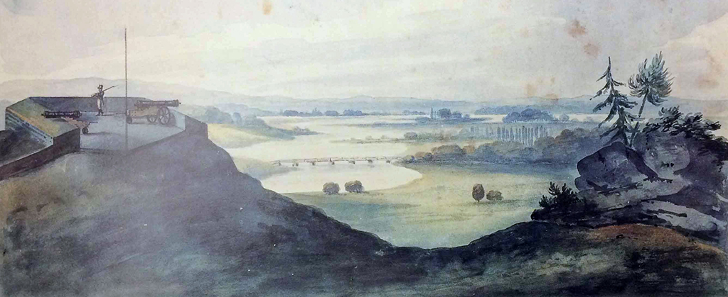
The history of northern Central Park is told through its rocks and hills — topography that was ultimately instrumental in Frederick Law Olmsted and Calvert Vaux’s design and had influenced the use and settlement of the area long before Central Park was even a consideration. Topography directed the Kingsbridge Road to this area. Beginning around today’s Madison Square, the road followed the route of the Wickqueasqeck Trail, used for centuries by the Lenape, traveling along the east side of the island and into the Bronx where it split into the post roads leading to Albany and Boston. Around 91st Street, it veered west to avoid the Harlem Creek, entering the park site and then meandering through the rocky hills. Here, beginning in the 1680s, several taverns were established to serve travelers. Where the road descended toward the plains of Harlem, the surrounding hills became a valuable strategic outpost from which to monitor travel along the island. During the Revolutionary War, the British occupied the area and the hills to the west, building encampments and fortifications along the heights. During the War of 1812, the United States Army reestablished the strategic position when awareness of British naval troops moving up the Atlantic coast sparked rumors of an impending attack on New York. Militiamen and volunteers hastily constructed three fortifications connected by earthworks supporting the gatehouse in the hopes of deterring an attack from the north. Along heights to the west, they built a series of blockhouses — small towers intended to be mounted with cannons — one of which still survives hidden in the park’s woodlands. The War of 1812 fortifications never saw any action. The war would end soon after they were built, and the forts were abandoned in the landscape, largely forgotten until plans for the park were underway.[1]
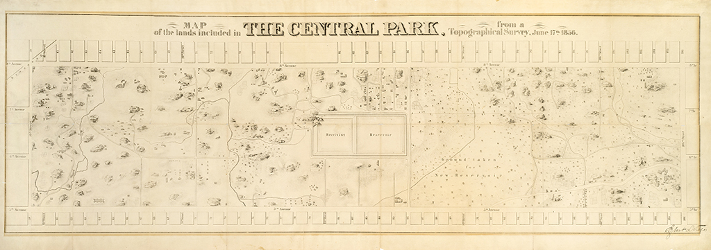
The prevalent myth about the park’s creation at the time was that nothing, or at least nothing of value, occupied the site of Central Park. Engineer Egbert Viele, who oversaw the first survey of the land in 1856, painted a disparaging picture of an excessively swampy and rocky terrain, “a pestilential spot, where rank vegetation and miasmatic odors taint every breath of air.”[2] An early report on the Park’s construction similarly characterized the southern portion of the site as “filthy, squalid, and disgusting.”[3] The approximately 1,600 mostly immigrant residents of this “straggling suburb” were typically portrayed as squatters amid hovels, plundering the landscape for fuel and sustenance and operating deleterious industries. Several bone-boiling operations and other small factories displaced from the increasingly crowded downtown did operate in this region, but the area’s largest settlement, Seneca Village, was home to a longstanding community of primarily African-American landowners who worked as grocers, domestics, and laborers.[4]Contempt for park site dwellers, redolent of contemporary racism, perhaps served to validate the process of eminent domain through which they were evicted from the land.
These depictions further dramatize the unprecedented endeavor to create the city’s first large public park. An August 1861 article in Harper’s described surveyors’ efforts in the context of the partially completed park: “The history of their adventures among the rocks, and jungles, and bogs of the then rude and desolate tract would be pleasant and surprising reading now in the dainty arbors, on the flowered walks, or by the marge of the pretty lakes, into which the jungles and bogs have since been so wondrously transformed.”[5]
Countering the portrayal of the pre-park site as wasteland was the still prevalent impression of the completed park as a preserve of the pre-urban landscape. Soon after the park was completed, Horace Greeley, editor of the New York Tribune, reportedly exclaimed: “Well, they have let it alone better than I thought they would!”[6] Greeley’s statement illuminates an underlying complexity in defining the park and designed landscapes in general. The park was a massive construction effort, lasting ten years and costing five million dollars. Its designers and builders didn’t leave it alone — yet the construction of an idealized rural landscape in the midst of the city ultimately involved transformation and preservation, creating the illusion of a familiar place that had been there all along. This interplay was particularly evident in the creation of the northern part of Central Park.
In a letter to Central Park’s commissioners, Olmsted attempted to explain how and why the existing landscape should guide, and be enhanced by, Vaux’s and his design:
“The time will come when New York will be built up, when all the grading and filling will be done, and when the picturesquely varied, rocky formation of the island will have been converted into foundations for rows of monotonous straight streets, and piles of rectangular buildings. There will be no suggestion left of its present varied surface, with the single exception of the few acres contained in the Park. … It therefore seems desirable to interfere with its easy undulating outlines and picturesque rocky scenery as little as possible, and, on the other hand, to endeavor rapidly, and by every legitimate means to increase and judiciously develop these particular individual and characteristic sources of landscape effect.”[7]
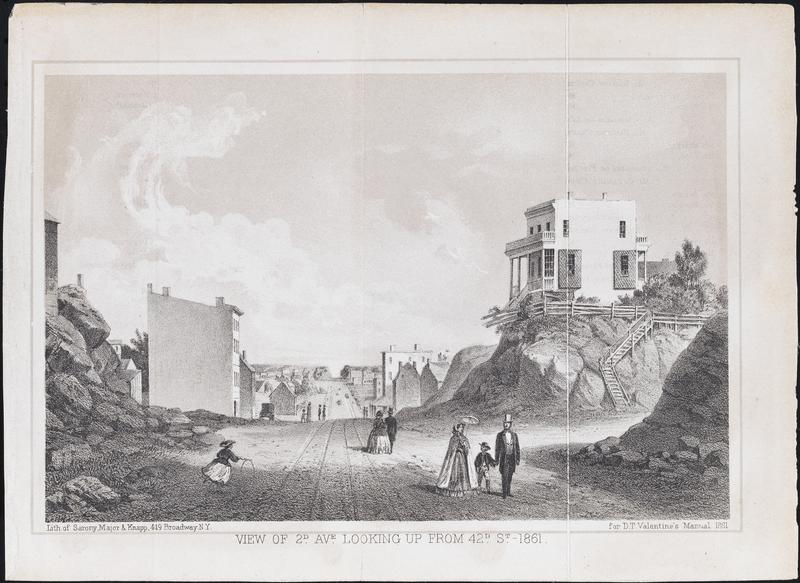
As Olmsted was writing these words, articulating a correspondence between place and design that would shape the new profession of landscape architecture, the landscape surrounding the park was being eradicated to construct Manhattan’s grid of streets according to the Commissioner’s Plan of 1811. Photographs and illustrations of this process show a tumultuous and disorienting transformation. In the wake of newly graded streets, piles of rocks lay next to homes perched precariously on the remaining, now exposed outcrops that would soon be leveled as well. Did the disappearance of this landscape inspire a new appreciation of it?
The existing landscape clearly provided a guide for Olmsted and Vaux: lakes were constructed in the locations of low-lying swamps, meadows were created in less rocky expanses, and woodlands in more densely vegetated areas. However beyond convenience or necessity, many of the site’s existing geologic and topographic features were preserved or manipulated; they were the foundation of both the existing and the idealized, constructed landscape, the “characteristic sources of landscape effect.”
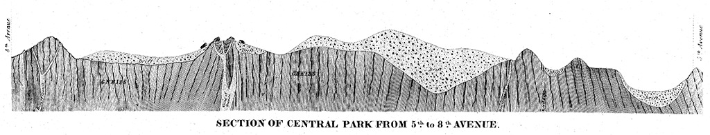
Varied approaches to the site’s geology provide further evidence of a more complex view of the landscape: the park’s planners and designers presented rocks at once as scientific marvels, obstructions to design, and evocative design features. The original survey of the site includes a detailed account of rock types that betrays definite interest and transports the landscape into a vastly distant temporal realm. The schist outcrops are the remains of a mountain range formed up to one billion years ago; its granite veins — according to the survey consisting of quartz, feldspar, mica, magnetite, black tourmaline, and scales of green chlorite and red garnet[8] — were created when molten rock penetrated that bedrock underwater half a million years ago. The last momentous activity in the geology’s formation occurred a comparatively short 75,000 years ago when a glacier dragged rocks over the schist, leaving scars, striations, and boulders — glacial erratics — strewn across the landscape.
Jump ahead to 1858 for the next major geologic event: the park builders blasted away rock with gunpowder to create roads and tunnels and clear the way for lawns. The rocks were interesting until they became ubiquitous obstacles. Early park guidebooks listed the regularly scheduled blastings, inviting curious New Yorkers to spectate. Witness and diarist George Templeton Strong described an intensely aural experience: “They were all around us for some twenty minutes, now booming far off to the north, now quite near, now distant again, like some desultory ‘affair’ between advanced posts of two great armies.”[9] The blasting left new scars on the rocks, still visible alongside glacial striations.
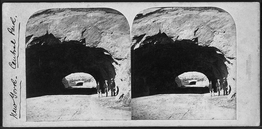
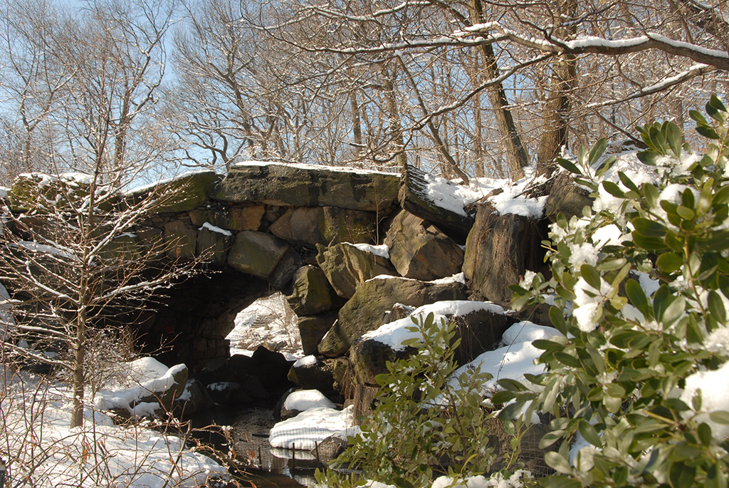
The elaborate rock formations and undulating hills in the northern part of the park site were, however, presented as a benefit; they coalesced to form a readymade picturesque landscape that needed less improvement, less blasting. Here, rocks were left to their own devices, over time becoming marvels inspiring wonder and exploration: their surfaces moist and dripping from mysterious water sources, their crevices harboring tiny ferns, their granite veins glinting in the sunlight. The park’s designers also reshaped these rocks into bridges, waterfalls, and stairs that further enhanced the area’s rustic character. Clarence Cook, the author of an early guide to the park, described experiencing the mortar-less Huddlestone Arch as a confusion of nature and artifice veering into the sublime: “a savage and dangerous looking tunnel, under which we pass for the first time with not a little inward misgiving, which nothing but our confidence in the skill of the Park engineers enables us to overcome…[An] ample, comfortable seat of rustic wood-work enables us to get pleasantly accustomed to the horror of the situation while we eat our luncheon.”[10]
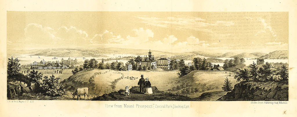
The experience of openness and prospect on the hills and ridges of the northern portion of the park site was also lauded and incorporated into the park’s design. Descriptions of the hills’ panoramic views notably focus viewsheds away from the encroaching city toward the distant, rural landscapes of Westchester, Long Island, and the Palisades, even capturing, according to one account, “the smiling villages of New England.”[11] One of the few remaining illustrations of this area prior to development depicts the view east from a particularly broad and tall hill near 8th Avenue and 105th Street as a bucolic domestic scene, replete with grazing sheep and a cow. This hill was incorporated into the park as the Great Hill, the borrowed scenery reiterating the park’s purpose as an escape from the city, making the landscape “the best convenient resort for parties desiring a ‘day in the country.’”[12]
In 1864, workers excavating at the Great Hill discovered a stone fireplace, likely the remains of a Revolutionary War encampment.[13] While it’s unclear what became of this discovery, other vestiges of the area’s military history were incorporated into the park in the hopes of drawing visitors to its north end, still far from the centers of population. The original boundaries of the park site were extended from 106th to 110th Street, to include the forts and the continued rugged terrain. Paths directed visitors to the fort sites which functioned as scenic overlooks, perpetuating their historic use as vantage points. They were and are still referred to by their historic names: Fort Clinton, Nutter’s Battery, and Fort Fish. Designers treated the remaining blockhouse as a folly and trained ivy to grow up its walls. Perched atop a massive outcrop, this was another noted overlook. A guidebook described its northern views encompassing other new parks with similar histories and futures.[14] To the west was the site of Morningside Park, and to the east newly completed Mount Morris Park (renamed for Marcus Garvey in 1973), both rocky expanses used for military defense redesigned for urban recreation.
The recent project in the Fort Landscape aimed to restore the deteriorated landscape and redesign the fortification sites, whose use as overlooks had been formalized over time. This involved peeling away more modern additions — fences, asphalt, and benches — and designing site features to recede into the landscape, allowing the eye to wander to the true spirits of this place: the hills and rocks and views.
The park’s planners, designers, and early chroniclers clearly appreciated this pre-park landscape, finding that “no portion of the park contains more features capable of improvement, or more points of beauty and interest.”[15] Contending with the ceaseless construction of the city reaching north toward the park and the unplanned, semi-urban settlements at its south end, they gazed wistfully at the still rural hills in the distance, and Olmsted implored on his superiors to see the value in preserving Manhattan’s “easy undulating outlines and picturesque rocky scenery.” This praise for the existing landscape dispels the myth of the overall site as an unpromising wasteland and acknowledges these northern landscapes as a template for what the park’s creators wanted it to be. While the park is well-understood as a historic landscape, further study of its northern landscapes elucidates the great extent to which history – natural, social, and political – informed, and is revealed through, its design.
···
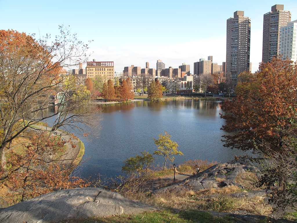
Walking through the northern hills today, I experience these layers and their interactions, moments of the park as a repository of memory. Descending toward the Harlem Meer, I notice how the curve of the path follows the route of the Kingsbridge Road, its surface possibly just feet below me. From the Great Hill, the views of the Midtown skyline reaching new heights have replaced vistas of distant rolling hills. And as I descend and ascend the winding paths among rocky outcrops, I still escape the monotony of the grid and catch a glimpse of Mannahatta, the Lenape word meaning “island of hills.” These rocks embody many histories, from the movements of glaciers to jarringly linear manmade impressions — some born out of panic, others created with an ardent desire to mold nature, thus shaping urban culture.
This section is derived from research conducted by Hunter Research as part of the archaeological investigations. James Lee and Richard Hunter, Archeological Testing and Monitoring: Forts Landscape Reconstruction Project, Central Park (Trenton, NJ: Hunter Research, January 2014).
Egbert Viele, First Annual Report on the Improvement of the Central Park (New York: Chas. W. Baker, 1857), 12.
Board of Commissioners of the Central Park, Second Annual Report (New York: William C. Bryant: 1859), 2.
For more on residents of the pre-park site see Roy Rosenzweig and Elizabeth Blackmar, The Park and the People: A History of Central Park (New York: Henry Holt and Company, 1992), 59-77.
T. Addison Richards, “The Central Park,” Harper’s New Monthly Magazine CXXXV (August 1861): 291.
Quoted in Charles E. Beveridge and David Schuyler, editors, The Papers of Frederick Law Olmsted, Volume III: Creating Central Park, 1857-1861 (Baltimore: Johns Hopkins University Press, 1983), 18.
Olmsted to the Board of Commissioners of the Central Park, May 31, 1858 in The Papers of Frederick Law Olmsted Volume III, 176.
Viele, First Annual Report, 18.
George Templeton Strong, excerpt from “Diary 1859,” in Empire City, editors Kenneth T. Jackson & David S. Dunbar (New York: Columbia University Press, 2002), 203.
Clarence Cook, A Description of the New York Central Park (1869; reprint New York: Benjamin Blom, 1972), 175-176.
“The Present Look of our Great Central Park,” New York Times (July 9, 1865), 3.
A Guide to the Central Park (New York: A. O. Moore and Company, 1859), 23.
Board of Commissioners of the Central Park, Eighth Annual Report for the Year Ending with December 31, 1864 (New York: William C. Bryant & Co, 1865), 8.
Cook, A Description of the New York Central Park, 173.
Viele, First Annual Report on the Improvement of the Central Park, 74.
The views expressed here are those of the authors only and do not reflect the position of The Architectural League of New York.