


Series
Intersections
As designers and urbanists engage with LGBTQ+ identity, what role do gender and sexuality play in the preservation, design, and management of urban space today?
In This SeriesWe are celebrating 15 years — and counting — of stories that are deeply researched and deeply felt, that build a historical record of what the city has been.
In their often-trying search for safety, community, and opportunity over the course of the second half of the twentieth century and into the twenty-first, queer households have actively participated in — and often even spearheaded — many of the now familiar patterns of urban “regeneration” in cities across the country. In this essay on “lavender lining,” urban historian Gabrielle Esperdy makes these links — between sexuality, race, class, and real estate — concrete. Beginning with the process of “redlining” from the 1930s, Esperdy asks us to see the “gayborhoods” in urban areas across the country of subsequent decades as built within pre-existing lines whose drawing was anything but innocent, and whose effects are still apparent today, if only in a slightly new color. – JM
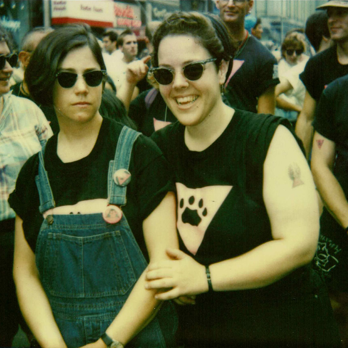
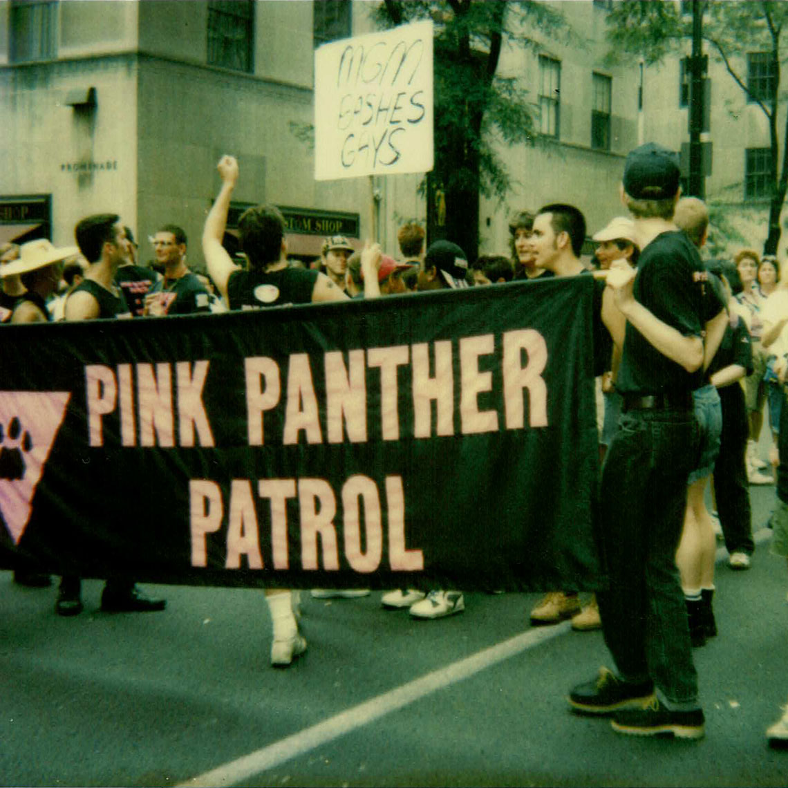
For a brief period in the early 1990s, I patrolled the streets of Greenwich Village in the wee hours of the weekend as a member of the Pink Panthers, a neighborhood watch group founded in response to rising incidents of gay-bashing and other forms of anti-queer violence. Equipped with whistles and walkie-talkies, and wearing fabulous T-shirts, we escorted folks from the clubs to the subway and from the piers to the PATH train, regarding ourselves as activists, not urbanists. Nonetheless, those midnight to 3am walks across Christopher Street were my first real experience with the complex socio-cultural dynamics of what I now think of as queer urbanism.[1] Though the rainbow flags hanging from building facades and displayed in store windows suggested unity, fissures were already apparent between the well-heeled retail establishments catering to mostly middle class, mostly white gays and lesbians and the social service organizations catering to at-risk LGBT youth and homeless people with AIDS, who were mostly Black and Latino. New York’s gay mecca may have celebrated its diversity across class, race, and gender, but this was also a neighborhood whose stress points were becoming as visible as the queer folk themselves.
Today there are still plenty of rainbow flags on Christopher Street as it heads southwest from Sixth Avenue to the Hudson River, but this is no longer a “Main Street of Gay America,” and not just because that sobriquet implies a monoculture of sexual orientation that never actually existed.[2] As gentrification and social acceptance have expanded contemporaneously, if not quite in tandem, the urban transformation that real estate wags call the “straightening” of the West Village has come to seem inevitable.[3] Social critics point to heterosexuals pushing baby carriages and to rising rents and apartment prices as evidence of this demographic shift. But alongside the anecdotal and statistical, we might also consider a more monumental marker of the neighborhood’s changing character: President Obama’s 2016 creation of the Stonewall National Monument, including the Stonewall Inn itself and seven surrounding acres. Exploring the meaning of Stonewall’s inclusion in the system of national parks is not only a way of beginning to map the psychogeography of queer placemaking, it is also a way of comprehending queer participation, and even complicity, in the past half century of urban evolution. Gay men, lesbians and trans folk were oppressed and marginalized (and depending on their racial and class identities this may have operated along multiple lines), but they were also urban actors and stakeholders whose increasing visibility in urban neighborhoods would have profound socio-economic consequences, ones they could hardly have anticipated back in the summer of 1969 when the NYPD made a routine, but fateful raid on the Stonewall Inn.
The police raid that June ignited what came to be known as the Stonewall Rebellion, six nights of protests and riots in and around a bar patronized by homosexuals (but, like others in the neighborhood, owned and controlled by members of the Genovese crime family). The Stonewall National Monument recognizes the importance of that event to the modern struggle for LGBT civil rights. As the first national monument associated with queer Americans, Stonewall’s designation is undeniably important. This recognition insists on an LGBT presence in our cultural memory and raises LGBT social status from historically marginal to historically significant. And given the nexus of national monuments and tourism, the designation also has consequences for economic development, at present and in the future. But at a more fundamental level, national monuments always look backward rather than forward. When the National Park Service labels buildings and places “monuments,” it is explicitly connecting them to events of great social significance that took place before the present day. Stonewall may still function as a workaday gay bar in 2018, but in many other respects, Stonewall is history. So while the past lives on in plaques of commemoration and chronicles of protest, it is perhaps most vivid on those special occasions — both spontaneous and scheduled — when the symbolism of the Stonewall Monument is unmistakably legible in the present tense.
When, for example, the US Supreme Court handed down the Obergefell v. Hodges opinion on June 25, 2015, making marriage equality the law of the land, crowds of people — many without prompting by social media — joyfully flocked to Stonewall Place, as the block of 53 Christopher Street was renamed in 1989. A few days later, as they had every year since 1985, the sponsors of the Pride Parade — itself the largest and most raucous commemoration of the rebellion — painted a lavender stripe down the middle of the street, not just on Stonewall Place, but running from the parade’s stepping off point at 36th Street, down Fifth Avenue, across Eighth Street and along the length of Christopher Street in the heart of the Village. Each year, on the third Sunday in June, this lavender line does more than simply mark the parade route: out there in the urban landscape, it signifies queer territoriality in a highly visible, if ephemeral, way. Indeed, it is precisely because the Village has become progressively less queer in the last quarter century that this marking of territory becomes more significant, and symbolic.
The lavender line, like the parade itself, is a reminder of a different era — after Stonewall, before AIDS. In this way, the act of painting the lavender line on Christopher Street is akin to carrying the Giglio on Havemeyer Street every July during the Feast of Our Lady of Mount Carmel. As Italian Williamsburg fades away and “New Brooklyn” expands, the ritual becomes more of an exercise in nostalgia with each passing year.[4] A parallel between ethnic enclaves and those predicated on non-normative sexual orientation is useful because tribalism of identity is at work in both. It also serves as a reminder to take the long view with respect to queer urbanism. Like the development of earlier immigrant communities in New York and cities across the country, the emergence of recognizable queer districts has a history that reaches back across much of the 20th century. Stonewall itself traces its roots to the 1930s, when Bonnie’s Stone Wall teahouse was regularly patronized by a variety of non-conformist downtown denizens, including gays and lesbians. It was the Village’s well-known permissiveness and established bohemianism that made it a reasonably tolerant environment for lesbians and gays before World War II, as long as they observed the era’s social protocols and requisite discretion. In those days, folks outside normative sexual and gender identities conveyed queerness mainly through the performance of personal style in ways that were frequently invisible or at least illegible to straight, mainstream Americans.
After World War II, however, they began increasingly and openly to delimit queer territory by creating communities that accepted queerness in visible ways, most famously (some might say stereotypically) in the Village in New York and the Castro in San Francisco. But these queer places also existed in cities both large and small in every part of the country, from Worcester to Buffalo, from Washington to Atlanta, from Kansas City to San Diego, from Flint to Des Moines. These weren’t always identifiable neighborhoods with clear physical boundaries; such communities could also emerge as spatial networks connecting, say, a dance hall and a softball field, or an all-night cafeteria and a public park. By the 1960s, though, it was possible to recognize queer community-making as an intentional social strategy, even if it was not necessarily part of an organized or cohesive plan — at least not one orchestrated by the queers themselves. The term “lavender-lining” is an effective way to describe this emergent queer urbanism.
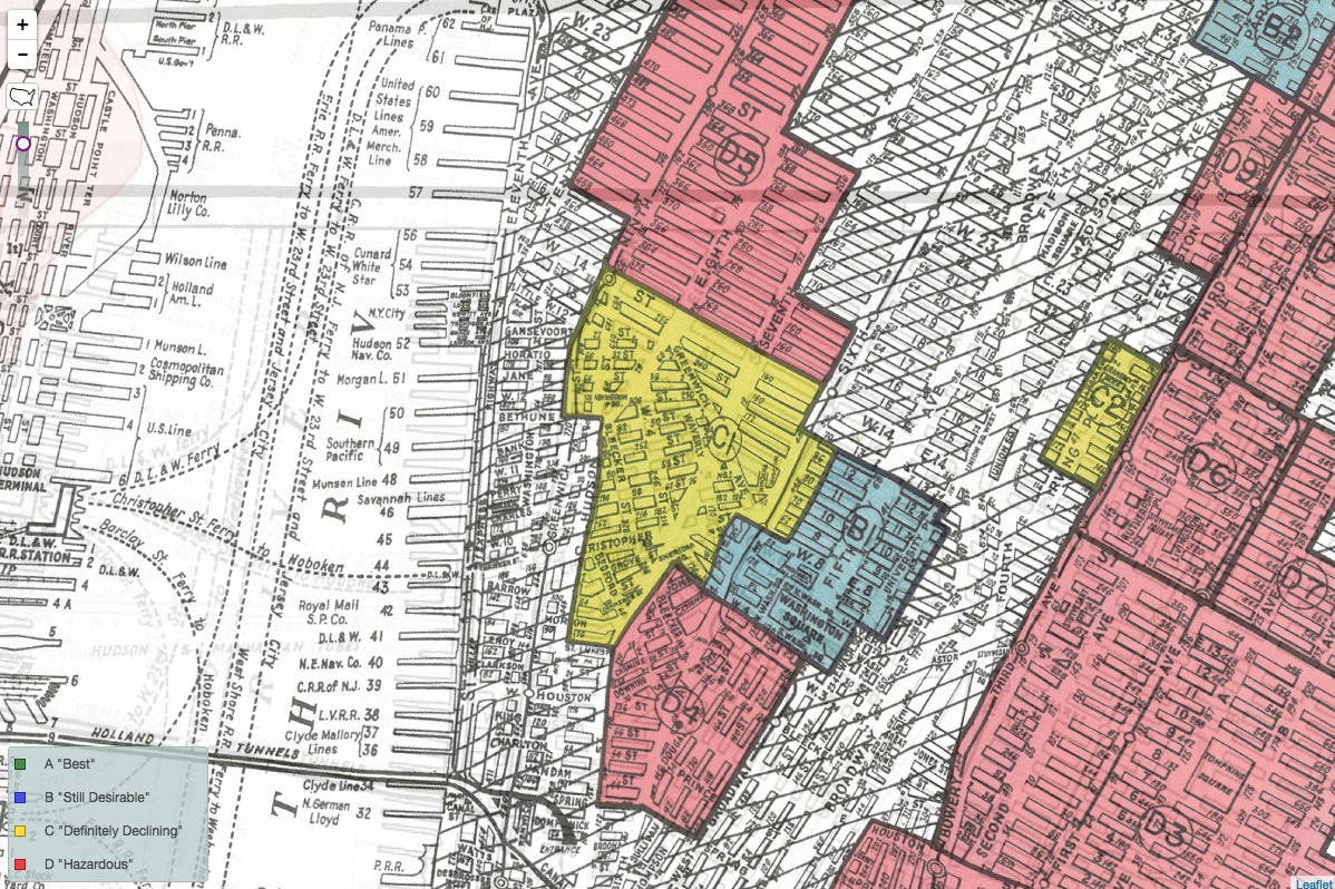
As much an urban phenomenon as a tactic of urban analysis, lavender-lining is a neologism that deliberately combines the celebratory marking of gay pride parade routes with the discriminatory practice of drawing red lines on maps to identify urban areas supposedly undesirable for mortgage insurance and investment purposes. Redlining emerged from the federal government’s entry into the sphere of housing finance, when in the late 1930s the Home Owners’ Loan Corporation created residential security maps to rate and visually represent urban neighborhoods on a scale from secure and “highly desirable” (outlined in green) to risky and “undesirable” (outlined in red). In between were neighborhoods outlined in blue (still desirable) and yellow (in transition towards undesirable). While the physical state of building stock in these neighborhoods was an important factor in determining their suitability for investment, so was their socioeconomic character. Areas identified as ethnically and racially diverse were regarded as hazardous or obsolete, and were outlined in yellow or red, depending on their level of infiltration by non-whites, and those of Southern European stock whose ethnicity or religion had prevented them from assimilating as white.
Lavender-lining is uncomfortably, but necessarily, built upon this foundation. It redeploys the boundary-defining tactics of redlining to map midcentury socio-sexual liberation. It does so with full knowledge of redlining’s corrosive history and multigenerational impact, on African Americans in particular, but also recognizing that in many cases the lavender lines drawn around emerging queer territories traced the same areas that had been targeted for disinvestment a short time before. Though this has not yet been thoroughly cross-referenced to the 239 cities for which residential security maps exist, the historical record (drawn from archives and narratives) suggests that gays and lesbians frequently settled in, worked in, or frequented neighborhoods that had been devastated by the post-war cycle of deferred maintenance, disinvestment, and (straight) white flight that redlining intentionally exacerbated. These were generally places where rents were cheap and ignored by the dominant culture as geographically or culturally marginal. In the parlance of security mapping, they were “blighted,” but not necessarily slums. Nonetheless, by 1970, these urban enclaves were being referred to as “gay ghettos,” indicating the social stigmatization of their inhabitants and the rundown appearance of their streets and buildings — though, of course, queer folk moved to such areas by choice. Those whom they displaced, or lived alongside for a time, occupied inner-city neighborhoods because of racial and economic discrimination.
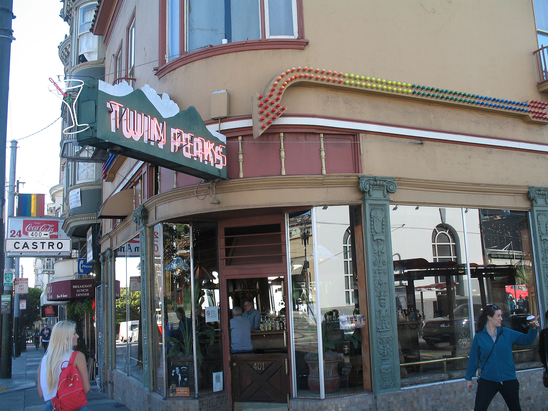
Initially, lavender-lining arose from the clustering of bars, bookstores, bathhouses, and other business catering to lesbians and gays. During the AIDS epidemic, neighborhoods solidified their queer identity by providing gay-owned, operated, and/or patronized commercial enterprises, and LGBT health and community services. As these services proliferated, neighborhoods and individual businesses outed themselves, making their queer identity highly visible — as a few trailblazers had done at least a decade earlier. Twin Peaks Tavern in the Castro opened in 1972 with a wide-open plate glass storefront that refuted back alley secretiveness. Indeed, it was a world away from the mob-run tavern on the opposite coast: Stonewall in the late 1960s featured dim lighting and an interior so closed-off from the street that patrons regarded it as a fire hazard. Though the broken windows fronting Christopher Street remained boarded up for some time after the uprising, transformed into billboards for displaying slogans of pride and protest, they were a harbinger of what was to come. In the following decades. neighborhood merchants would display storefront pink triangles and rainbows to indicate gay-ownership or gay-friendliness, as they do to this day. Window decals, then, became a way of asserting queer territoriality, a gesture more modest than a lavender stripe in the street, but also more enduring, if hardly permanent.
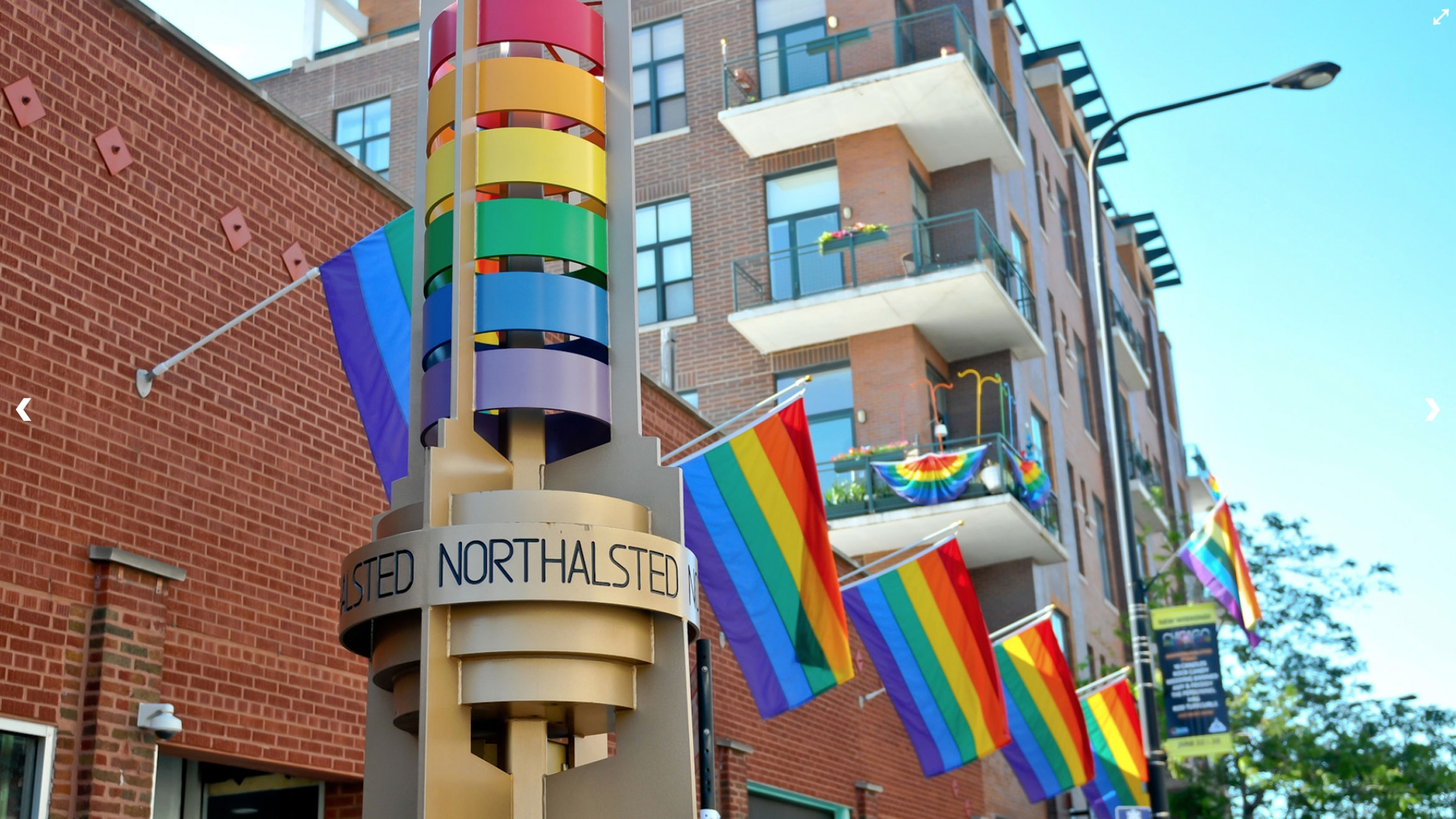
One of the most institutionalized examples of lavender-lining’s cultural impact occurred as part of a citywide effort in Chicago to strengthen neighborhood identity by promoting ethnic traditions. In 1998, the city proclaimed a portion of the eastern section of Lakeview, a northern neighborhood, as Boystown, marking the district with 22 rainbow-topped pylons along Halsted Street. Though many Chicagoans hailed this pioneering effort on behalf of the country’s first officially designated gay neighborhood, others were outraged that the city placed sexual identity on par with ethnic identity. Another complaint was that officially identifying the neighborhood as gay would hurt property values. It is hard to imagine a more ironic criticism since Lakeview, graded yellow on HOLC maps, was regarded as a blighted, crime-ridden area prior to its queer revitalization. In fact, when the city officially designated Boystown, it was, in effect, re-grading the area as “desirable,” a result of its gay transformation into a thriving upscale neighborhood. Today, though the city’s designation was the effect and not the cause, Boystown is confronting inflated property values and a straight incursion that threatens its queer identity.
In 2002, urban theorist Richard Florida (working with demographer Gary Gates) emphasized the positive socioeconomic impact of these queer urban enclaves when he codified the statistical relationship between gays and urban prosperity in a “gay index” that tracked “the rise of the creative class” across the country.[5] Although in the last quarter of the 20th century, the so-called “return to the city” transformed many 60s-era gay ghettos into contemporary “gayborhoods,” with all the upscale and friendly marketing that word implies, in these shifting urban territories, conflicting values and priorities related to race, class, and, of course, sexuality never really went away. In the West Village, in Boystown, or in the Castro, we find straight parents objecting to bondage gear in store windows, aging gays objecting to queer club kids hanging out in the streets, and everyone objecting to drunken frat boys. But anecdotal evidence masks a deeper unease about the impact of urban transformation, from the disappearance of affordable housing to the erosion of queer identity.
To comprehend a neighborhood as lavender-lined is to acknowledge the role that LGBT city dwellers played in this now well-established cycle of urban redevelopment. As a vanguard of queer “urban pioneers” made community for themselves in neighborhoods identified as blighted and targeted for disinvestment, they catalyzed fin de siècle gentrification with consequences as significant and far-reaching as the Stonewall Rebellion itself.[6] Claiming queer space in the city in the middle of the 20th century was a profound political act, but it did not take place in an urban vacuum. Though redlining was imposed from above and lavender-lining sprang from the streets, it probably felt the same to earlier generations of displaced neighborhood residents.[7] With the 50th anniversary of Stonewall fast approaching, and plans for commemoration already underway, it goes without saying that we must celebrate this landmark event — and the LGBT civil rights gained during the past half century. From my own perspective, as a middle-aged urban historian looking back at my younger urban activist self, my hope is that we seize Stonewall 50 as an opportunity to examine some difficult truths about queer urbanism, then and now. In the second decade of the 21st century, as queer residents of historically queer neighborhoods now feel the sting of displacement caused by a current wave of frequently straight newcomers, exposing the queer history of urban gentrification may be inconvenient and uncomfortable, but it is absolutely necessary.
This essay expands upon "Lavender-lining," published originally in The Arsenal of Exclusion and Inclusion edited by Interboro (New York and Barcelona: Actar, 2017).
For a contemporary analysis of the Pink Panthers, see Lauren Berlant and Elizabeth Freeman, “Queer Nationality,” boundary 2 19 (Spring 1992), pp. 161-162. See also Christina B. Hanhardt for discussion of the Pink Panthers and other gay street patrols in Safe Space: Gay Neighborhood History and the Politics of Violence (Durham: Duke University Press, 2013), especially chapter 4 on “Visibility and Victimization.”
Susan Taylor Martin, “AIDS Alters Life on Street that Launched Gay Movement,” Tampa Bay Times, 21 June 1987, p. 1.
For current use of the term “straightening” see Scott James, “There Goes the Gayborhood,” New York Times, 21 June 2017. On broader patterns of straight gentrification of queer neighborhoods see Amin Ghaziani and Michele Ghaziani, There Goes the Gayborhood? (Princeton: Princeton University Press, 2015).
Conservative economists use the term to describe the borough’s widespread revitalization while avoiding more divisive issues related to gentrification, affordability, and cultural transformation. See Kay Hymowitz, The New Brooklyn: What it Takes to Bring a City Back (New York: Rowman & Littlefield, 2017). For a review, see Alan Ehrenhalt, “The Rise of Brooklyn, What’s Wrong and What’s Right,” New York Times Book Review, 1 February 2017.
See also Gary J. Gates and Jason Ost, The Gay & Lesbian Atlas (Washington: The Urban Institute, 2004).
Ed Koch popularized the term “urban pioneers” in his first inaugural address. See “Text of Address Delivered by Koch at His Inauguration as Mayor of New York City,” New York Times, 1 January 1978.
Two classic studies of urban displacement produced by cycles of abandonment and gentrification are: Peter Marcuse, “Gentrification, Abandonment, and Displacement: Connections, Causes, and Policy Responses in New York City,” Journal of Urban and Contemporary Law 28 (January 1985), 195-240. Neil Smith, The New Urban Frontier: Gentrification and the Revanchist City (London & New York: Routledge, 1996). For a more recent and journalistic approach see Peter Moskowitz, How to Kill a City: Gentrification, Inequality, and the Fight for the Neighborhood (New York: Nation Books, 2017).
The views expressed here are those of the authors only and do not reflect the position of The Architectural League of New York.
As designers and urbanists engage with LGBTQ+ identity, what role do gender and sexuality play in the preservation, design, and management of urban space today?
In This Series