
We are celebrating 15 years — and counting — of stories that are deeply researched and deeply felt, that build a historical record of what the city has been.
We are celebrating 15 years — and counting — of stories that are deeply researched and deeply felt, that build a historical record of what the city has been.
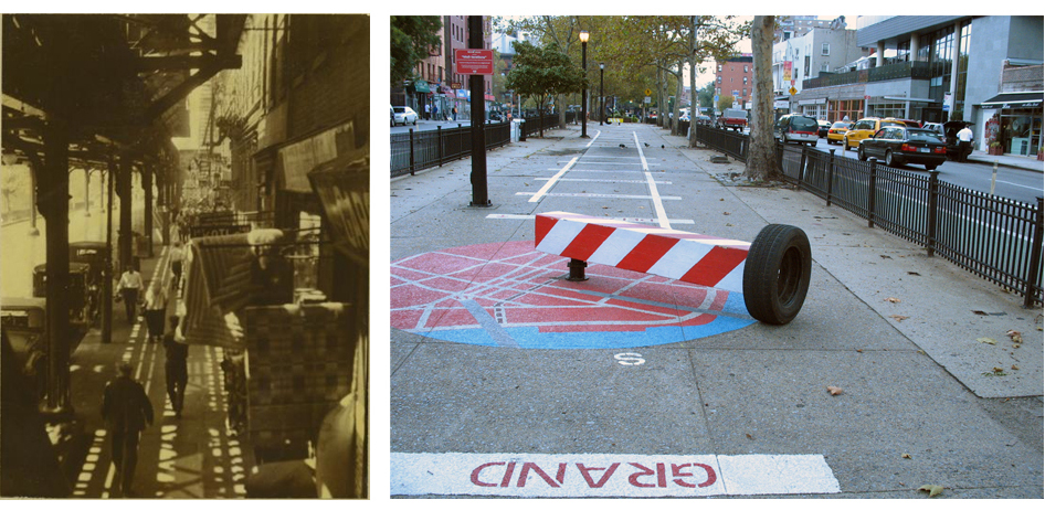
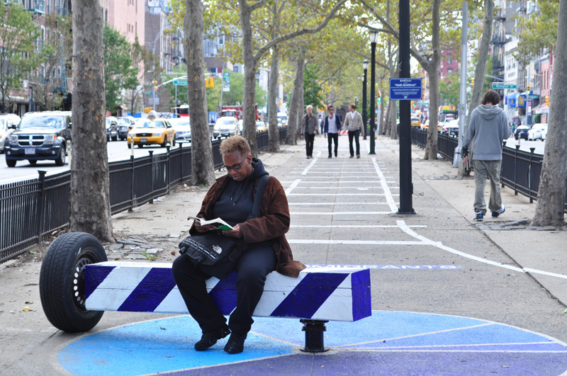
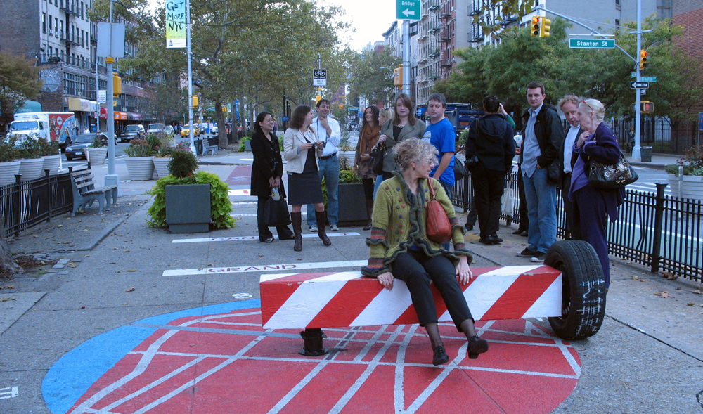
Last week Hester Street Collaborative (HSC) — a nonprofit that works at the intersection of design/build, education and advocacy from its home base in the Lower East Side and Manhattan’s Chinatown — unveiled a temporary public art installation on the Allen Street Pedestrian Malls. These “mall-terations” build upon years of advocacy and visioning HSC has undertaken with the residents of the Allen and Pike Street corridor in an effort to turn this underperforming streetscape into open space that provides places for residents to play and explore the history of their neighborhood. Created in conjunction with the Department of Transportation’s (DOT) Urban Art Program and a quartet of Venezuelan-bred, New York-based artists/designers (Carolina Cisneros, Marcelo Ertorteguy, Mateo Pinto and Sara Valente), the installation evokes some forgotten histories of a street also known as the “Avenue of the Immigrants,” in honor of its long history as a spine along which many communities of new Americans have established their homes for well over a century. For example, the line of white paint down the center of the mall from Houston to Delancey operates as a reminder of both the elevated rail line that used to cast its shadow on this street as well as the demolished block of tenements that used to take up what are now the eastern lanes of Allen Street.
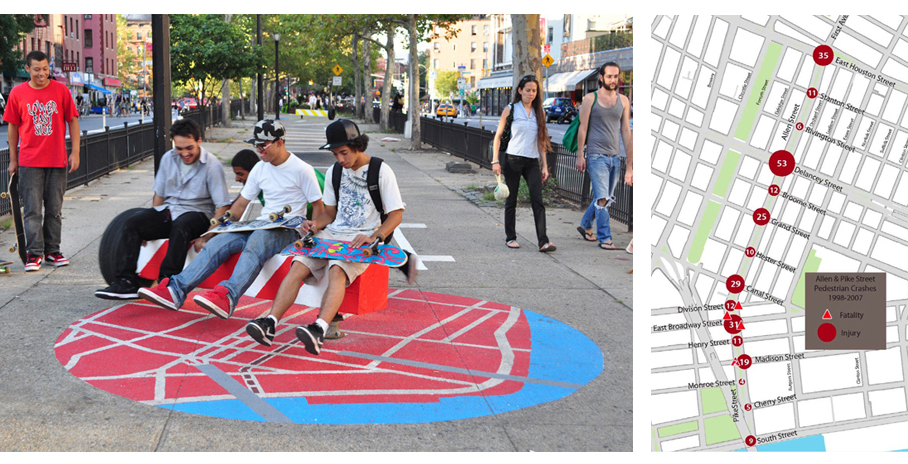
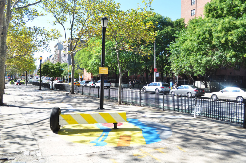
The guiding principle of the piece is historically informed wayfinding, yet, mercifully, this is a far cry from a tourist-oriented heritage tour. Maps, timelines and directions to nearby streets painted into the malls mark the path between a delightful series of mobile benches that function as seating, play structure and overgrown compass at once. The compass “dial” beneath each bench’s compass “needle” is a painted circle that depicts a map of the area in one case, a pie chart of neighborhood demographics in another, and a timeline of neighborhood history in a third. The history is rich, and it resonates poignantly with contemporary reality: Allen Street’s rail line was part of the Second Avenue Elevated, whose underground replacement, now dubbed the T train, has been under discussion since before elevated service was discontinued in 1940 and is now projected to open in 2016. The block of tenements that used to occupy the eastern side of the street were razed in 1930 under a predecessor program to Urban Renewal intended to clean up the slums of the Lower East Side. The same program created Sara D. Roosevelt Park, which runs along Chrystie Street two blocks to the west.
But whereas the demolition of two blocks of tenements made way for the green space and ball courts of Sara D., Allen Street received a series of median malls, cemented directly over the foundations of the bulldozed buildings. The malls — there are 14 of them between Houston and South Streets — have been neglected for the past fifty years, beginning the moment the benches were ripped out to discourage use by habitual drug users and the homeless. That pattern of neglect may be coming to an end. The Parks Department, which maintains the malls, has funding to rehabilitate at least five of them, starting with those closest to the waterfront. DOT has already instituted some temporary improvements, including signaling changes and the provision of protected bike lanes aimed at improving road safety. But just because Allen Street is seeing some overdue capital improvements does not mean that active processes of engaging community members’ vision for the space should cease.
The Hester Street Collaborative has been involved in advocacy efforts around re-envisioning the malls since 2003 and was aware of desire within the community for some rehabilitation efforts further north as well. So they set out to transform the northernmost malls, between Houston and Delancey. Which brings us to the real power of “mall-terations:” they attest to the way an art intervention can foster a sense of transformative possibility and community involvement in the design and programming of public space. That seems to be exactly why the DOT is interested to work with artists and community-based organizations to realize projects like this. The DOT’s Urban Art Program “is an initiative to invigorate the City’s streetscapes with engaging temporary art installations.” The pARTners track, under which the mall-terations received support, invites not-profit organizations to propose a temporary public art installation (for up to 11 months) on DOT priority sites. The “mall-terations” will be on view through the summer of 2011.
The views expressed here are those of the authors only and do not reflect the position of The Architectural League of New York.

Comments