
We are celebrating 15 years — and counting — of stories that are deeply researched and deeply felt, that build a historical record of what the city has been.
We are celebrating 15 years — and counting — of stories that are deeply researched and deeply felt, that build a historical record of what the city has been.
These days, arguments for the expansion of public transit options in New York City cite increased demand in growing areas, congestion on certain lines, the need for additional capacity. But in the first half of the 20th century, transit planning anticipated patterns of urban development, rather than merely responding to them. The legacy of proactive investment in infrastructure is not just recorded in the written accounts of the period, but inscribed in the physical traces of uncompleted projects. Joseph Raskin explores these vestiges in his book Routes Not Taken: A Trip Through New York City’s Unbuilt Subway System, and in the article below, takes Henry Grabar on a tour of the G train and the remnants of transit ambitions along its route. Grabar’s account of their journey reminds us that in an era when disused infrastructure is being reimagined for other public purposes — parks, museums, bike paths — forward thinking about how to adapt the city’s systems to accommodate expected growth should not be forgotten. — C.S.

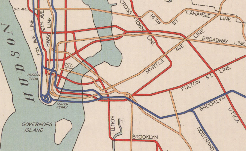
Above: Detail from New York City’s 1939 subway plan; Below: Legend for New York City’s 1939 subway plan | Image via Wikimedia Commons
Between the Bowery traffic and the brick walls of Confucius Plaza Apartments, just south of the Manhattan Bridge pedestrian path, a row of gridded vents breaks the ground. It’s a clue that a subway tunnel lies below, but no trains rumble underfoot. The vents, like pneumatic mail tubes or trolley rails sunk in asphalt, appear to belong to that class of urban infrastructure that long ago lost its purpose.
In fact, the opposite is true. Their time has not yet come. Built in 1973 during an abortive attempt at the Second Avenue Subway, these vents and the tunnel below will soon celebrate a half-century of waiting.
Currently under construction again, “the line that time forgot” is the most famous of New York City’s unfulfilled transit ambitions. But it’s far from the only one to make a preemptive mark on the city. Throughout subterranean New York, platforms, mezzanines, stairways, and tracks lie dark not because service was abandoned but because it never arrived. Like the stunted branches of a drought-stricken tree, these bits of infrastructure regularly protrude from the busy trunks of the subway system. You would see them every day if you knew where to look.
Joseph Raskin knows, better than anyone, where to look. He is the author of Routes Not Taken: A Trip Through New York City’s Unbuilt Subway System, and an expert on the alternate history of transit in the five boroughs. Raskin works in community relations for the Metropolitan Transit Authority (MTA). Off the job, he has spent the last 25 years studying the subway’s endless history of what-ifs. His book, eleven chapters devoted to forgotten people and fantastic schemes, is a history built on blueprints, memos, and newspapers. But it’s also a field guide to a subset of urban archaeology: the steel and concrete ghosts of New York’s grand, unfinished plans.
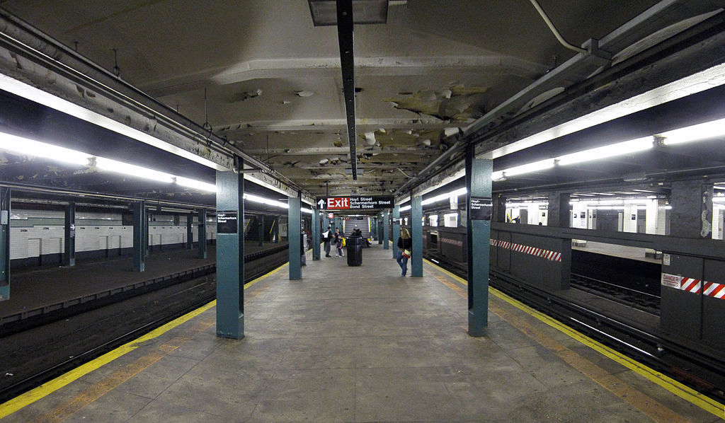
Hoyt-Schemerhorn Station; one of the disused platforms can be seen to the left. | Image via Wikimedia Commons
Hoyt-Schermerhorn
On a rainy spring evening, Raskin took me on a tour of the subway line now known as the G train. Like many New Yorkers of a certain age, Raskin often refers to subway lines by their original, geographical names. The F train is the Culver Line; the G the Crosstown Line. These date from the era when two companies, the Interborough Rapid Transit Company (IRT) and the Brooklyn-Manhattan Transit Corporation (BMT), ran the subway. The City entered the fray with the Independent Subway System (IND) in 1932, and the three branches were consolidated as a public agency in 1940.
We met at the Hoyt-Schermerhorn stop in Downtown Brooklyn, the city’s only single-level, six-track station. Two peripheral tracks and platforms, dark and steel-dusted, once served a shuttle that ran to Court Street in Brooklyn Heights. In the late ‘30s, the City planned to extend those tracks beneath the East River to link with the Second Avenue Subway, a proposed IND line. That’s all but impossible now, both financially and politically — the work would tear up half of Brooklyn Heights, Raskin noted.
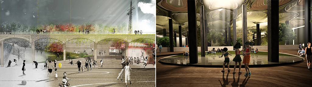
The Court Street Station, though, belongs to the special set of old transit infrastructure that has found a beneficial reuse. (See also: the High Line.) Its platform, tracks, and mezzanine are now home to the New York City Transit Museum. Various similar sites, like the Lower East Side’s Williamsburg Trolley Terminal (envisioned as an underground park called the Lowline), the defunct LIRR Rockaway Beach Branch (which might one day be the QueensWay Park), and the City Hall Station (a National Historic Landmark that remains largely off limits to visitors) have been reimagined as pedestrian destinations.
But under a debt-strapped MTA seeking to offload assets like air rights (see Hudson and Atlantic Yards), transit has not been a priority in infrastructure reuse. Tracks like those that line the proposed QueensWay were once used for something besides post-industrial décor. The Chinatown tunnel may one day house a power substation or a ventilation facility, but will never run Second Avenue Subway trains.
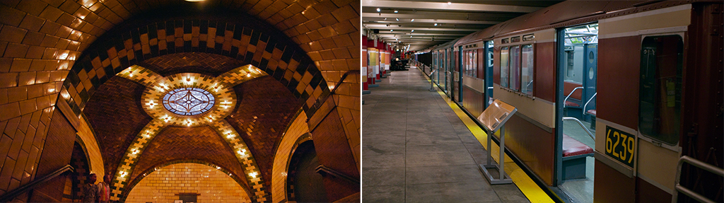
City Hall Station (left) and the New York City Transit Museum (right) | Images via mikeric and Ed Yourdon
Bedford-Nostrand
Raskin and I were exploring the legacy of an old New York construction mantra: “Do stuff now, so if you have to go back and build something, you won’t get in the way of customer service.” The practice unfortunately lost favor during New York’s mid-century burst of highway construction: both the Van Wyck and Long Island Expressways might have, for a small added cost, provided a dedicated space for transit in their medians. But it has regained currency: at Hudson Yards, a $185 million tunnel is being built to preserve the possibility of a future interstate rail connection.
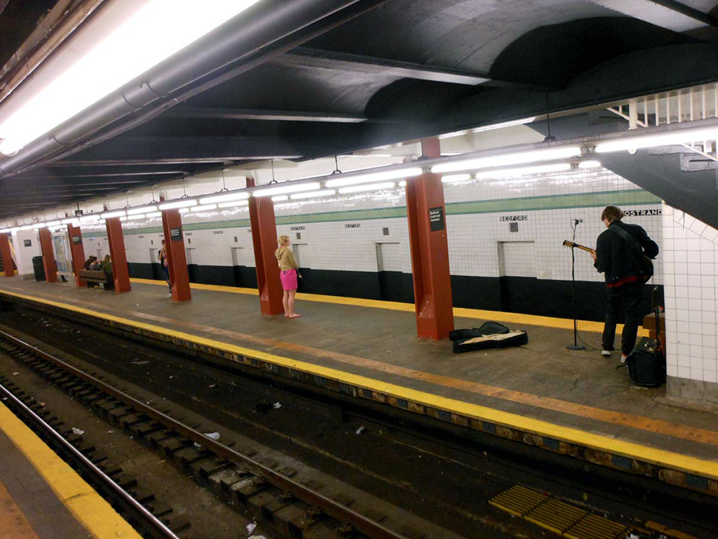
The third, extra track at the Bedford-Nostrand G train station | Image via Cecilia Dougherty
We disembarked at the Bedford-Nostrand G train stop, which, with its extra platform and extra track, is a prominent example of that forward thinking. It’s one of dozens of three-track stations in New York, some of which — as in the Bronx — run peak-direction express service. But here, in the center of Bedford-Stuyvesant, this extra track is all that remains of a Depression-era plan to extend subway service east, along Lafayette Avenue, through what is now one of central Brooklyn’s largest subway deserts. The area was once served by sections of the BMT’s Myrtle Avenue and Lexington Avenue elevated lines, demolished in 1969 and 1950 respectively.
It’s a trace of the tumultuous history of the Crosstown Line, whose contours wriggled through 23 separate proposals between 1905 and 1963. Was it to go above ground or below? Should it merge with existing lines? Thousands of New Yorkers turned out to public hearings on the subject. One popular idea was to send the line south to merge with what is now the Franklin Avenue shuttle, connecting Coney Island and Prospect Park to north Brooklyn and Long Island City. This was heartily endorsed by Charles Ebbetts, owner of the Brooklyn Dodgers, whose ballpark would have been on the proposed route. Brooklyn industrialists pushed to run the line closer to the water, an idea that has recently attracted new interest.

Detail of the 1929 plan of the Independent Subway System (IND) proposing new subway routes (shown with thick black lines). Shown here, the South 4th Street Line runs from the Lower East side to Marine Park. | Image via Wikimedia Commons
Broadway
To reach Lower Manhattan from the Broadway G stop, you must walk three blocks to the J/M/Z line at Hewes Street and take a train over the Williamsburg Bridge. But there were grander goals for this station. Up a sealed set of stairs from the current platform lies the shell of a six-track, three-platform station, one of many fingerprints the so-called South 4th Street Line left across Manhattan and Brooklyn.
Part of the ambitious 1929 expansion plan, the South 4th Street Line’s two Manhattan branches would have joined in a trunk line here at Broadway. The northern feeder would have come under the East River as an extension from the Second Avenue station. The southern feeder would have taken a separate path beneath the water, curling across Lower Manhattan from what is now the A/C/E Canal Street station. East of Williamsburg, two branches were planned to cut into Queens. A third would have veered south down Stuyvesant and Utica Avenues.
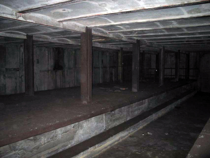
The shell of a planned South 4th Street Line station above the Broadway G train stop | Image via HopeTunnel.org
The ghost of South 4th Street lingers: in the extra tracks at the Second Avenue F station, in the tunnels south of Canal Street on the A/C, in an additional platform at Roosevelt Avenue in Queens, in the ceiling of the Utica Avenue station on Fulton Street.
That’s where the facts end and Raskin’s speculation begins. “It’s one of these things I think but can’t prove,” he tells me, not for the first time, as his mind wanders down Utica Avenue towards Jamaica Bay. Variously envisioned as an extension under the control of the IRT (from Eastern Parkway), the BMT (from the Canarsie L Line) and the IND (from South 4th Street), Utica Avenue once seemed a sure bet to join the city’s subway network. Real estate companies speculated and sold land in anticipation of the train’s arrival.
Three blocks south of Eastern Parkway, at Carroll Street, the Utica roadway widens from four lanes to six. Could this be a legacy of the plan to run trains down its center? Raskin believes so. The grand goals of the expansion era had impacts on the subterranean city. Why not the streets as well?
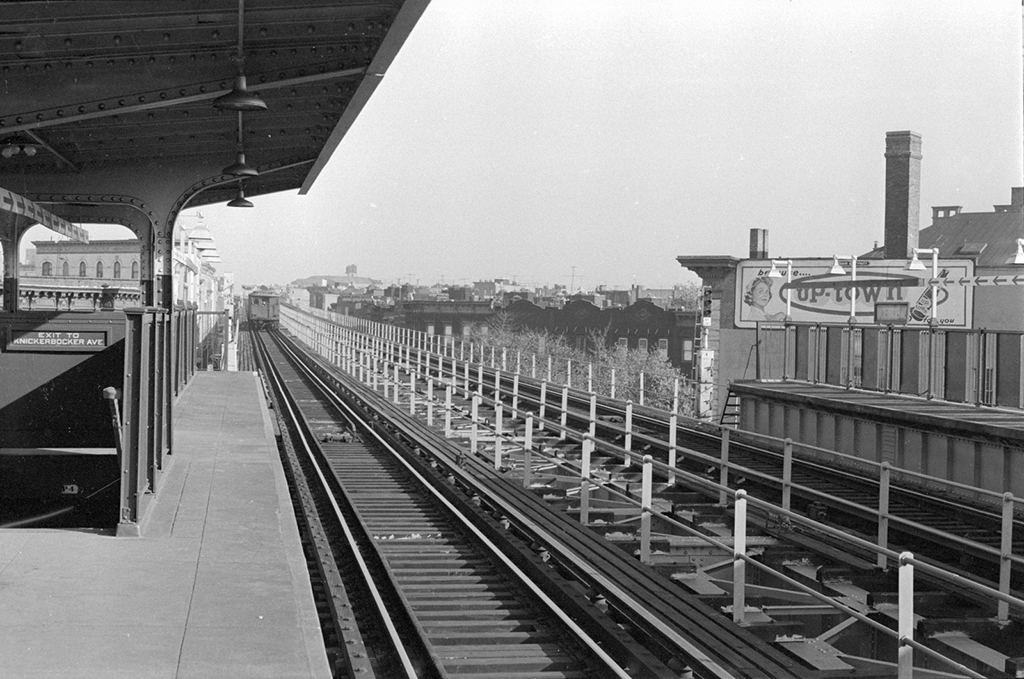
Myrtle Avenue El in 1960 at the Knickerbocker Avenue Station | Image via Patrick Cullinan
Greenpoint Avenue
As the rush-hour traffic dwindled, Raskin and I pondered the subway map on the mezzanine level. To his eye, this rather spare wayfinding tool encrypts dozens of forgotten permutations. He talked of the seldom-used Culver Line express tunnel sweeping beneath Prospect Park, the Myrtle Avenue elevated that once ran over the Brooklyn Bridge to Park Row, the cancelled Coney Island express that jumped from Sunset Park to the foot of Brooklyn in just three stops. Back in the 1980s, Raskin remembered, you could see signs for “South Ferry via the Queensboro Bridge” out in Flushing and Astoria. But trains stopped running over the bridge in 1942.
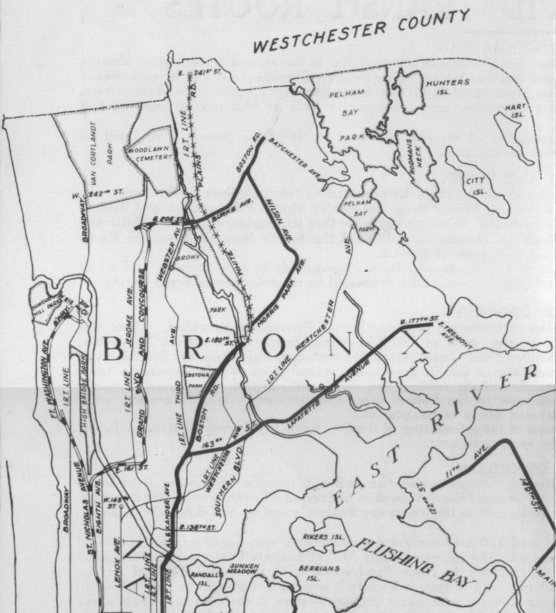
Looking at the Bronx, at the curving end of what is now the D train, Raskin was reminded of why he started this project a quarter-century ago. “Every so often I would find something that would absolutely floor me,” he said. He stumbled upon a map of the 1929 plan, which showed that hooked northern terminus at 205th Street extending along Burke Avenue to the east, right past his father’s childhood home. For Raskin, it was just another line on the drafting board. But his father recalled it as a historical event. “I showed him the map, and he remembers from when he was a teenager, this is like 1937, 1938, that he saw guys from the Board of Transportation doing preliminary engineering work. And I go: ‘Whaat?!’”
“That hooked me,” he concluded.
Detail of the 1929 plan of the Independent Subway System (IND) proposing new subway routes (shown with thick black lines) | Image via Wikimedia Commons
Time has since hardened the curves of New York’s subway map. The colored bands now feel as fixed as the outlines of the boroughs or the paths of the streets. A new addition is a once in a generation event, if that. But as Raskin ran through all history’s accidents and coincidences, the paths of the network came to look more and more fortuitous. Existing routes appeared less than inevitable; bygone schemes seemed equally plausible.
Their traces lie sprinkled across the city, reminders of how short New York’s transit planning fell of its ambitions. Rail construction once led New York forward — the first subway lines often passed by farmland, particularly in the Bronx and Queens, but even in neighborhoods like Manhattan’s Upper West Side. Now, infrastructure plays catch-up — in the case of the Second Avenue Subway, as any morning commute on the neighboring 4/5/6 trains can attest, the MTA’s efforts lag nearly a century behind New Yorkers’ living patterns.
Yet the forgotten segments exude a dusty optimism. They are memorials to expansion plans once thought likely enough to pour concrete in preparation. So little was built, yes. But so much once thought possible.
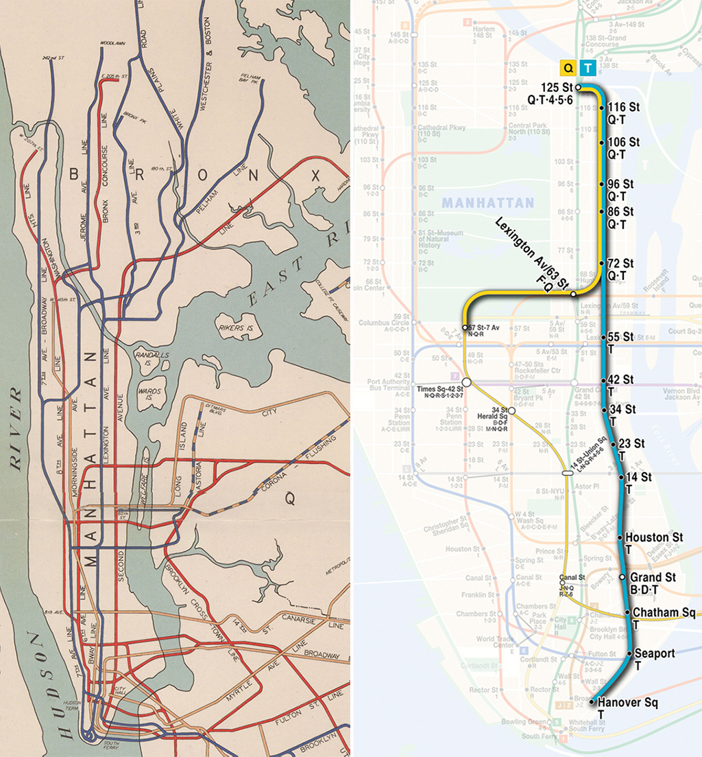
Plans for the Second Avenue Subway, 1939 (L) and today | Images via Wikimedia Commons and MTA
The views expressed here are those of the authors only and do not reflect the position of The Architectural League of New York.
Comments