
We are celebrating 15 years — and counting — of stories that are deeply researched and deeply felt, that build a historical record of what the city has been.
We are celebrating 15 years — and counting — of stories that are deeply researched and deeply felt, that build a historical record of what the city has been.
You spend a lot of time mulling over life while waiting for the bus in the Southeast Bronx. On a typical workday, after a five-minute walk to the Bx27 stop on Rosedale and Seward Avenues, I stop, take a deep breath, and begin my morning routine of anxiously assessing my transit options. I pace between the posted bus schedule and the street corner, craning my neck past a long line of parked cars and imploring the gods of public transit to send salvation barreling around the bend. After a few minutes, faithless and desperate, I retrieve my phone to open up MTA BusTime (sitting unthreatened atop my “Most Visited” list), which on most mornings confirms my fears: the nearest Bx27 is anything but near.
Now, with the clock steadily ticking down toward the start of my shift, panic seeps in. My brain races through permutations of transit options with the speed of an Intel chip.[1] “I can bite the bullet and wait here for the bus to come, or I can take the risk of walking fifteen minutes to the Bx5, but in doing so, that Bx27 might race right past me while I’m in between stops. And at any rate, who knows how long I’ll have to wait for the Bx5 to come. What if I miss both? And what if there’s traffic on the Bruckner? By the time the Bx5 merges on and back off, it’ll be lunchtime! But the Bx5 will take me to Hunts Point, where I can catch the 6 express and shave a good 15 minutes off of my commute. Time’s running out, though! Maybe I should just cab it to the train—but do I have enough cash? The nearest ATM is a five-minute walk away—what if a bus comes in the meantime? Plus, can I even afford another cab? Third time this week, $10 a pop—and the second time I’m severely late. Will my boss let it slide again? What if I lose my job? How will I pay for law school? For student loans? For anything, really?” Suddenly, what should have amounted to just another commute has once again cascaded into this brutal exercise in self-reflection: my finances, my career, my life as I know it, are all on the chopping block. I’m nearly paralyzed with impotence and angst. And still no bus. And no cabs in sight. Tick… tick… tick….
Is it silly to conflate one’s employment prospects and livelihood with something as trivial as a bus schedule? At an individual level, it might seem so. At the metropolitan scale, however, the connection is more evident: those who must commute farther to reach job-saturated areas, or who live in transit-starved neighborhoods, are less likely to be and stay employed, or to be informed about and take advantage of new job opportunities.[2] They also endure costlier commutes, longer days, and limited time for leisure or loved ones—or practically anything not work-related. Within a city, equitable access to transit is vital for equitable quality of life.
Chiseling equity from rampant social inequality demands the fulfillment of certain sine quibus non. In the case of transit equity, two requirements are crucial. First, service reliability is key: workers must be able to expect conveyances to pick them up from given locations at set times, just as employees are expected to report promptly to their places of work—which benefits employers, too, since reliable transit makes for reliable workers. The existence of redundancies is equally important: Commuters throughout the city must have access to multiple, practically located, economical transit options to reach their homes, their loved ones, and most vitally, their jobs.[3]
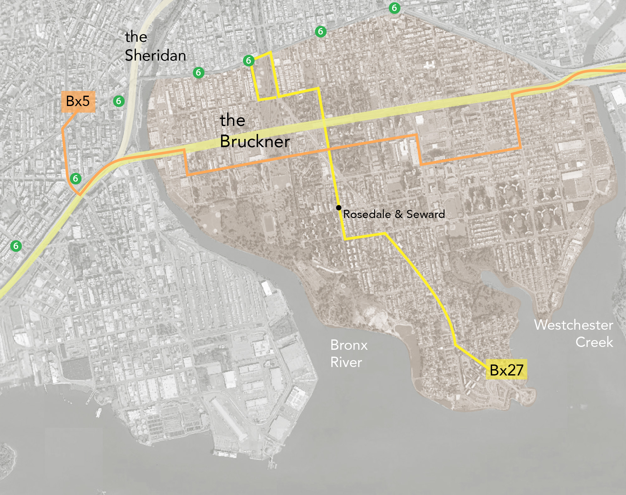
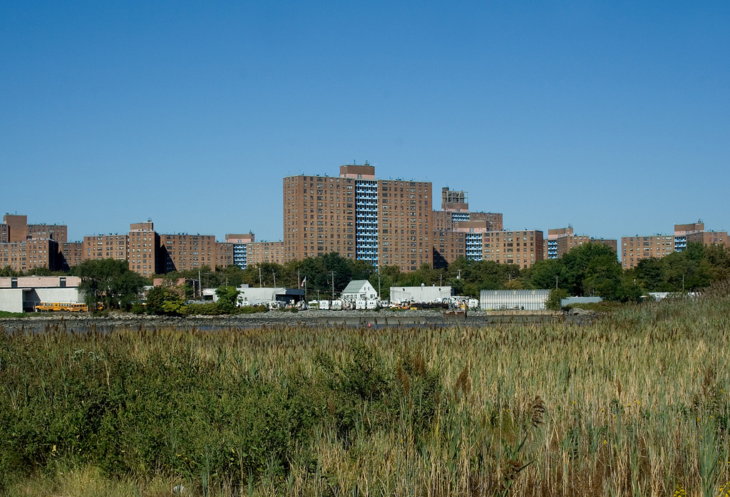
The Soundview Peninsula, where I and 58,000 others live, has neither of these sine quibus non.[4] In this part of New York, as in far too many others, a dearth of transit options creates or exacerbates hardships for its residents. Soundview has been disadvantaged by an array of familiar forces—historic and current, geographic and political, coincidental and concerted—that converge to hinder residents’ access to the rest of the city.[4] In a word, these forces both box us in and box us out of the rest of New York, making it disproportionately difficult to take advantage of all the city offers.
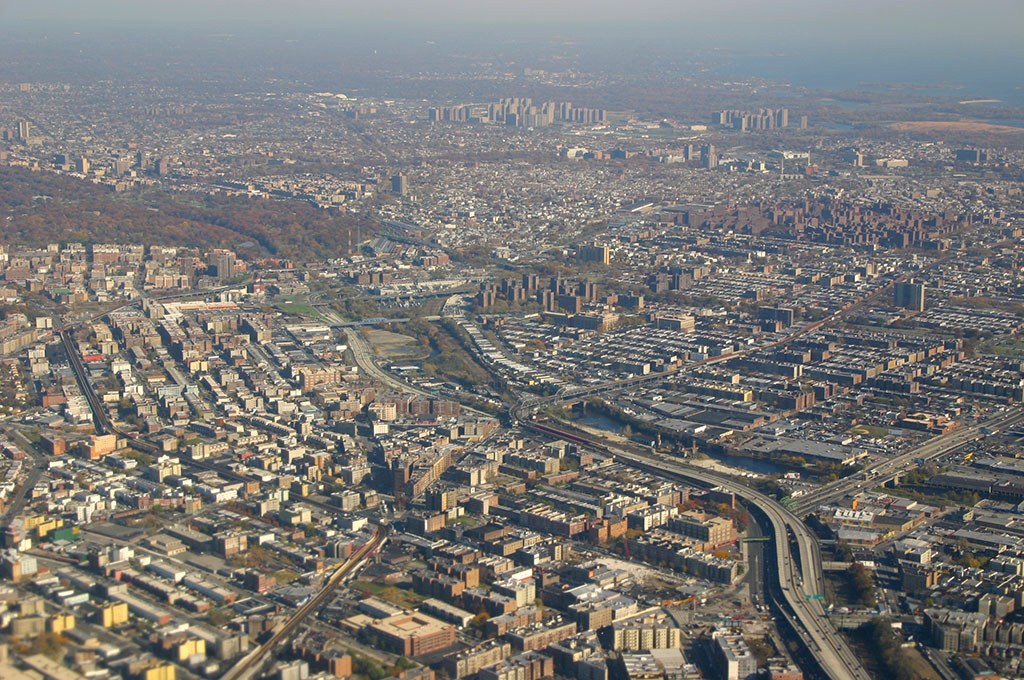
Bounded to the west by the Bronx River, to the east by Westchester Creek, to the south by the East River, and to the north by the Bruckner Expressway, the Soundview Peninsula is virtually an island. Lacking reliable connections to the rest of the borough and the city, Soundview is much less connected than many actual islands in New York City. Perhaps even more so than the water itself, the culprit of this isolation is the Bruckner, and the burdens that its design imposes upon residents.
Consider, for instance, that the expressway runs at-grade as it rips across the peninsula, but is elevated both west of the Bronx River and east of Westchester Creek. As a result of these design decisions, Hunts Point and Port Morris, together a historically critical epicenter of city industry, as well as the middle-class, quasi-suburban white enclaves of Schuylerville and Throgs Neck were spared the obstructions that scarred Soundview. Or, consider the few options available for crossing the expressway: for the entire 2.2-mile peninsular segment, only five cross streets exist for local drivers and buses, and only four pedestrian overpasses exist, meaning pedestrians only have opportunity to cross the expressway roughly once every quarter mile. Comparatively, the average city block is about 0.05 miles long; in any given 2.2 miles, then, drivers and pedestrians would have closer to 44 crossing opportunities, rather than five or nine.
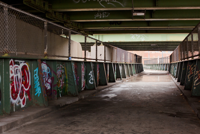
Furthermore, White Plains Road and Castle Hill Avenue are the only surface-level pedestrian crossways. Others run underneath barely-elevated segments of the expressway, through poorly-lit tunnels turned into homeless encampments, or prowled by predators. The rest are overpasses, neglected “non-places” strewn with trash, broken glass, and drug paraphernalia, reeking of waste and booze.[6] For vulnerable populations—children, the elderly, disabled people—the options for safe, reasonably located passage are few.
The problems compound for residents like me, the carless who need to get downtown to the central business districts. For most people on the peninsula, there are only two bus routes heading in that general direction: the Bx5 and the Bx27. And both routes are ruled by the tyranny of the Expressway. The Bx5 runs either parallel to or directly along the Expressway for most of the peninsula’s width, forcing those further south to walk between 15 and 40 minutes—or entrust themselves to some additional form of transport, with all concomitant delays, costs, and inconveniences—in order to intersect it. More vexingly, riders headed west toward downtown trains find themselves at the whims of the Bruckner, as the Bx5 must merge onto it to cross the Bronx River and reach the stations. This little trans-river segment is an infamous bottleneck since, just as one is back on terra firma, the Sheridan Expressway juts down from the North to merge with the Bruckner. Estimating how long the bus will take to complete this 0.4-mile span is a crapshoot, and basing transit decisions on such an estimate often proves foolhardy.
Meanwhile, the Bx27 traverses the length of the peninsula’s western half and connects riders to the 6 train. But when one accounts for the Bx27’s notorious unreliability, combined with the infrequency of downtown 6 trains at Morrison Avenue-Soundview, dependable transit is virtually impossible to find.[7] For a Soundview commuter, then, it’s easy to feel that you, your family, and your community are getting the absolute short end of the accessibility stick.
The vast majority of the Soundview peninsula went undeveloped until the post-war advent of urban renewal and the highway construction booms radically transformed its landscape. The only outlier was Clason Point, the section at the peninsula’s cape, which grew popular over the first half of the century. Its beachfront and unobstructed views of Manhattan and Long Island Sound gave it a seaside atmosphere New Yorkers could previously only find in the farthest reaches of southern Brooklyn. At its peak, Clason Point rivaled Coney Island, equipped with landing docks for ferries from Manhattan and Queens. Riders were greeted by massive dancehalls and an amusement pier on the waterfront, and beach bungalows immediately behind.
This sparkling world at the water’s edge masked how starkly undeveloped Soundview was. Topographically, Soundview was less beach than bog, a marshland kept waterlogged by the numerous tributaries and stagnant creeks surrounding and penetrating it. Even well into the 1940s, the high costs of developing the fenny region far outweighed the financial incentives of doing so, effectively preventing private development. As Manhattan built up denser and taller just across the river, Soundview remained surreally pastoral.
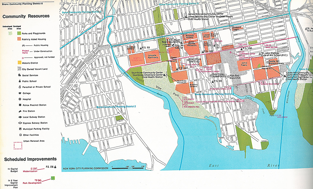
But when urban renewal got into swing at midcentury, planners selected the peninsula, among several other parcels with low realty values and undesirable locations, for public improvement projects. Developers complemented aggressive slum clearance efforts with equally aggressive housing construction, and Soundview was a primary site: Public and publicly-subsidized housing development through 1974 added nearly 12,100 units to what had until recently been farmland, and black and Puerto Rican families flowed rapidly into the area to populate them.[8] White flight, prompted by these demographic and architectural transformations, accelerated the area’s degeneration into what sociologists call a “hyperghetto,” a no man’s land where thousands of the city’s poor were herded into four massive projects orbiting the Bruckner, in a neighborhood quickly draining of social, political, and financial capital.[9] By 1970, a new Soundview—distinctly black and Hispanic, crushed by poverty and asphyxiated by violence—was in full bloom.[10]
Today, the six-lane, 100-foot-wide Bruckner remains a dividing line between Soundview and the mainland. And yet, since neither its design nor its surroundings sufficiently provide for crossing or circumnavigating it, the Bruckner doesn’t merely divide—it restricts. Most of us are familiar with the various legal and extralegal mechanisms that administrative and financial institutions throughout the U.S. once unscrupulously employed (and in some places, still do) to regulate the movements of individuals and the mobility of groups. Redlining, predatory lending, restrictive covenants, racial zoning, and “separate but equal” have all been widely explored in urban and architectural scholarship. Officials have devised remedies like Mandatory Inclusionary Zoning to help ameliorate these mechanism’s lingering harms. But we must also consider how physical structures themselves restrict, regulate, and ostracize—and how to remedy their effects.
Legal scholar Sarah Schindler conceptualizes the harms that such structures present as “architectural exclusion”: the various ways that elements of the built environment isolate individuals, groups, and entire communities, thwarting their efforts to fully and freely engage in the freedoms and opportunities of broader society. This geographic isolation may also precipitate and perpetuate other forms of social regulation and exclusion. According to Schindler, architectural exclusion is particularly pernicious because of architecture’s “enduring nature.” The built environment—especially urban infrastructure—is intended to permanently transform the landscape. As Schindler laments, “nothing is currently forcing municipalities to confront the continuing harms that result from those past architectural decisions.”[11] Considering the cost of altering infrastructure, there’s also little persuading them to. Perhaps, though, by exposing the mechanisms that converge to perpetuate exclusion, as Schindler does, we can encourage transformations that promote greater inclusivity.
The truth is, the construction of the Bruckner Expressway from 1957 to 1972 was never meant to benefit Soundview, or any neighborhood in the southeastern part of the Bronx that it vivisects. Even at the time of its construction, establishment owners all along the route railed against the proposal, fearing—and predicting—the decay such projects often catalyzed. When Borough President James Lyons proposed an alternative, Robert Moses, the “Power Broker” himself, pulled millions in Bronx projects’ funding until Lyons acquiesced to his vision. Moses wanted a road that would link the Triborough Bridge to the New England Thruway and the Whitestone Bridge, facilitating access to Manhattan for suburbanites, even at the expense of Southeast Bronxites. Perhaps he didn’t specifically intend to cordon off a peninsula rapidly growing poorer and darker, but his short-sighted, overzealous planning approach ultimately did exactly that.
Between 1954 and 1961, four of the borough’s largest NYCHA developments opened in the immediate vicinity of the expressway’s peninsular section while it was still being constructed.[12] The effect, in aggregate, was to herd poor, unskilled, jobless minorities wholesale into massive housing projects in an underdeveloped area lacking basic public amenities and infrastructure, all the while building a 100-foot thick at-grade barrier that quarantined them from the rest of the city. These new residents were boxed in, and out, from all sides: walled in by road, held at bay by water. The outcome was virtually inevitable; one could argue that any city planner worth his wage could have and should have forecasted it. But Moses’s disregard for his own megaprojects’ segregative and isolating effects merely reflected the dominant view amongst his contemporaries: that the city had not been built for the lower and working classes, that it was not to be built for the countless ethnoracial groups making up the melting pot on which New York’s global, semi-mythic reputation is founded. For these constituencies, the design of the Bruckner was non-inclusive—or exclusive by omission.
This echoes another of Schindler’s chief arguments: The massive works that shape our cityscapes—skyscrapers, highways, bridges, plazas—are embedded with the values of those who design and realize them. They reflect, reinforce, and perpetuate those values in the landscape; they define, direct, and delimit possibilities for interacting with the city. Schindler notes that often “planners…make decisions that focus on urban infrastructure needs without considering the impact that such decisions might have on citizens.”[13] In order to establish truly equitable transportation networks, planners must consider their decisions’ impact on all citizens. In our case, the Bruckner was constructed to optimize access for those who could own cars and live in the suburbs, at everyone else’s expense. For those who must interact with but cannot utilize it, the expressway obstructs our access to the rest of the world. The Bruckner’s design calculus reflected the prioritization of the middle class, of whites, and of suburbanites over the city’s own working-class people of color—and its existence perpetuates it. As Schindler describes, “the built environment communicates, expressing the views of those who create it and imposing those views on those who interact with it each day.”[14] The Bruckner’s message to us: “Your needs are subordinate.”
Thankfully, the issue of transportation (in)equity is gaining prominence in cities across the U.S., galvanizing discussion and action nationwide. Anthony Foxx, the U.S. Secretary of Transportation, has helmed the movement himself to a great extent. Inspired by childhood memories—his home community in Charlotte, NC, was circumscribed and suffocated by interstate highways—he has continually spoken out against how unequal transportation access harms the economic mobility of underprivileged populations. Foxx advocates delivering transportation funding directly to city and county agencies that better understand local needs and dynamics, thereby curbing the influence of agencies of larger jurisdictions, whose transportation-related decisions have often proved myopic and misguided. Because much of our aging urban infrastructure will soon need replacing, he considers this an ideal moment for us to redevelop transportation networks in ways that right our predecessors’ wrongs.
A number of state and local agency projects currently underway in the East Bronx may finally make some strides toward a more equitable transit system for Soundview. Most prominent is the Penn Station Access Plan, which will add four new Metro-North Railroad stations along the East Bronx servicing roughly 95,000 additional riders. The plan would reactivate the existing Hell Gate Amtrak line, linking riders all along the New Haven line with the East Bronx and directly to Penn Station, with no stops between Port Morris and Midtown. This would create a slew of redundancies throughout not only the Metro-North, but the entire East Bronx transit network, providing alternatives for downtown travel to the overtaxed buses and subways. The plan has some key weaknesses, however—primarily, the MTA’s notorious tendency to stall major developments.[] There’s also pricing: With one-way fares slated to be nearly triple subway fares, the working-class constituents expected to frequent these new stations would likely find the costs of daily round-trip commuting prohibitively burdensome. Lastly, the plan doesn’t actually provide a solution for the nightmares of traveling on and off of the peninsula—prospective Metro North riders from Soundview would still have to cross the Expressway to get to the new stops. Still, the idea of an 18-minute dash from the East Bronx to Midtown is enticing, and could make the plan worthwhile even despite these shortcomings.
Another major development is the upcoming Citywide Ferry Service route that, beginning in 2018, will run from Clason Point Park to the East 90th and East 62nd Street piers before terminating at Pier 11 near Wall Street. With projected travel times of 18 to 43 minutes, this, too, would create much-needed redundancy in Soundview’s network and, if reliable, could present a truly viable alternative for efficient downtown commuting. To fully promote equity, however, the ferry must be supplemented by more frequent and dependable Bx27 and Bx39 service toward Clason Point Park, since traveling away from the subway may prove counter-intuitive and unattractive to commuters without a tangibly augmented service to justify reorienting their commutes. The proposed fare system also warrants concern: Ferry trips will cost $2.75, just like the subway or local buses, but the fare won’t include free transfers to other transit; those needing to continue their trips after de-boarding will suffer a commute twice as costly. Add to this both the additional time needed getting from the piers to one’s destination (or the subway), and the uselessness of the service to those working on Manhattan’s West Side (rush hour crosstown buses being notoriously sluggish)—there’s reason to suspect the service might not be fully embraced.
We’ll have to wait years to see if these developments correct Soundview’s inequitable transit access. Even if they do, they aren’t the only potential remedies. Congestion and inaccessibility issues could be improved by constructing a local street bridge at Lafayette Avenue across the Bronx River, or by adding a local street adjacent to, but separate from, the Bruckner Drawbridge. The New York State Assembly has at least finally approved (and allocated $97 million toward) the conversion of the much-despised Sheridan Expressway into a boulevard, which would stem the deluge of freeway traffic that creates a bottleneck at the Bruckner-Sheridan merging point just west of the Bronx River.[16] Considering city and state finances and the Southeast Bronx’s limited cultural and political cachet, I don’t know how feasible or effective these potential remedies will be, and I’m not a city planner just yet (fingers crossed). I’m just someone with big plans to make it in this city, like my eight million neighbors. The structures of our city, and the institutions that sustain them, should facilitate our dreams and our success, not hinder them.
Many transit apps, like Google Maps, Citymapper, Transit, and Moovit, claim to solve this conundrum, but their usefulness is limited. First, most of these apps use the MTA’s published schedules to calculate best routes, and rarely update in real time to account for delays. Secondly, these apps prioritize the simplest routes, and may not account for context-specific unorthodoxies. Any of these apps can tell you that, to get to Destination X at 9am, you should take Train A to Bus B, and to get there at 11 pm, you should take Train A to Train B to Bus C, or just take a cab. But they won’t give you an answer like “Take a cab to Train A, then get off and transfer to Train B, then transfer back to Train A,” even if, as it so often is for me on most weekday mornings, the most efficient option.
A 2014 NYU Rudin Center study found a significant correlation between transit access, income levels, unemployment rates, and number of “accessible” job opportunities—jobs that can be reached within one hour of transit—across New York City neighborhoods, corroborating the findings of other, national studies.
Case in point: 7am on October 16, 2015, when a single loose bolt at the 14th Street-Union Square station during the morning rush hour swiftly ballooned into a nightmarish backlog of stalled trains that forced 625 different delays, cancellations, and redirections spiraling out from four of the ten busiest stations in the city, and the most-used subway line in the nation. (See Robert Kolker’s New York article “One Day, 625 Delays,” for the full story.)
Both “Soundview” and “Sound View” have been used to refer to the peninsula, the general area around and including the peninsula, and a subsection and neighborhood of the peninsula itself. Clason Point and Clason’s Point have been used to refer to the peninsula as well as the neighborhood at the cape of the peninsula. Harding Park has also been used to refer to the neighborhood at the cape. For the purposes of this article, I use the term “Soundview” to refer to the general area, “the Soundview peninsula” to refer to the peninsula itself, and “Clason Point” to refer to the neighborhood at the cape.
Measured by census block group, residents in New York City as a whole tend to have 70 transit stops within a half-mile of their block, and Bronx residents average 62 stops; the census block designated to the NYCHA campus where I live has only 36. For comparison, however, Sotomayor Houses, a NYCHA campus to the immediate north of the expressway, has 64 stops. The number of jobs that the average NYC resident can reach within a 30-minute commute is a whopping 1,346,701, and 809,791 for the average Bronxite; but only 155,807 for my address. Sotomayor Houses? 836,336! The numbers are even starker when looking at the most lucrative and promising employment sectors in the city: white collar work. Jobs in these sectors, which offer the greatest potential for upward socioeconomic mobility, are decidedly out of reach for my south-of-the-Bruckner block, where only 15,389 such opportunities can be reached by transit in 30 minutes, compared to 250,760 for the average Bronxite and 411,735 for the average New Yorker. Sotomayor Houses have 283,705 of these top-tier jobs within 30 minutes’ reach. Meanwhile, 80.21% of residents in my block group depend on public transportation, spending 11.2% of their $22,308 median household income on transportation, versus 9.6% of $34,284 for the average Bronx resident, and 8.8% of $50,711 for the average New Yorker. All of which is to say that, alongside likely being poorer and less able to afford a car than your average New Yorker, a Soundview resident must bear the additional burdens longer commutes to reach job centers, hindered access to all types of jobs as a result, and severely limited access to the most promising of these jobs—especially striking when compared to residents of like qualifications who live on the other side of the expressway, simply because they happen to live on the other side of an expressway.
The term “non-place” was coined by French anthropologist Marc Augé in Non-Places: An Introduction to Supermodernity (1995) to describe spaces lacking the social, historical, symbolic significance of a place. Unlike museums, parks, or noteworthy buildings, “non-places” are often spaces that connect places, but aren’t destinations in themselves—such as subway stations or, say, expressways, overpasses, and tunnels. These places lack social and cultural meaning, and as such, are often unmonitored and protected in the way actual spaces are.
Having spent much of my life since I was twelve years old waiting for the Bx27, I can vouch that this route has suffered declines in frequency and reliability over the years. During the morning rush hour, buses are scheduled to come roughly every ten to twelve minutes on average. In reality, however, the buses are often delayed, and 20-plus-minute waits on weekday mornings are common. These delays become more severe in inclement weather; I’ve seen people shivering in blizzards for half an hour or more waiting for work- and homebound buses. These delays produce crowds at bus stops, filling the buses to capacity early on in their routes. Drivers of overfull buses may even skip stops, forcing the unlucky to wait even longer for the next bus to come.
The 1950 census reported that 93% of the peninsula’s 27,341 residents were white, which then dropped to 72% of 23,666 residents in 1960 and, a decade later, collapsed to just 50% of the 48,982 that called the peninsula home, despite an overall population increase of 107% between 1960 and 1970. A 1974 planning report noted that, since 1961, the greatest demand for housing in Soundview came from black and Puerto Rican families (especially following the construction of Co-op City, which spurred a mass exodus of white families from the Castle Hill Houses). The soon-to-be-completed Stevenson Commons and Boulevard Towers II was projected to bring the population to 148% of its 1960 levels.
The term “hyperghetto” was coined by urban sociologists Loic Wacquant, William Julius Wilson, and Willy Aybar to describe the accelerated decay they observed in the ghettos of Southside Chicago. Hyperghettos refer to inner city neighborhoods where the most underprivileged groups are extremely concentrated. See Wacquant’s and Wilson’s “The Cost of Racial and Class Exclusion in the Inner City” (Annals of the Amer. Academy of Political and Social Science, Vol. 501, Jan. 1989) for an in-depth treatment of the concept.
In the late 20th century, Soundview exemplified the very worst that life in the Bronx, New York City, and urban America had to offer. The violence reached bloody culmination in 1999, when four cops shot Amadou Diallo 19 times just north of the Bruckner simply for holding up what they presumed was a gun (it was a wallet). But since then, crime rates have dwindled to their lowest levels since the housing boom. Soundview’s 43rd precinct reported a 71% drop in crime rates from 1993 to 2010, with murder and burglary rates each seeing 80% declines, and car theft falling a staggering 88%. Average household incomes in Soundview’s zip code have increased by 39% since 2000. The peninsula currently boasts 24 primary and secondary educational institutions, including a private school and two charter schools; three branch libraries that combined loan over 336,000 items per year to locals; and 14 different city parks and playgrounds. Locals and their representatives have worked hard to make Soundview a better place to live, learn, and play.
See Sarah Schindler, “Architectural Exclusion: Discrimination and Segregation Through Physical Design of the Built Environment,” Yale Law Journal, Vol. 124, No. 6, April 2015, Page 2015 (her emphasis).
Three of these projects—Soundview Houses, Castle Hill Houses, and Monroe Houses—are south of the Bruckner Expressway; the other, Sotomayor Houses, is adjacent to the expressway on its northern side.
Schindler, p. 1945.
Schindler, p. 1997.
The current plan for the Second Avenue Line, the first phase of which is slated to open this year, was originally concocted in the 1970s, while variations of the idea have been in the works since the 1920s.
The State also allocated $288 million for a multiphase rehabilitation of the Bruckner viaduct (the elevated segment running from Third Avenue all the way up to the Bronx River), though the details for this project aren’t clear. If they include the construction of more on- and off-ramps for trucks traveling through the Hunts Point Peninsula, this project, too, could have a significant, if indirect, effect of alleviating congestion at the Bronx River bottleneck. Any improvements, however, would be years away.
The views expressed here are those of the authors only and do not reflect the position of The Architectural League of New York.

Comments