


Series
The Location of Justice
An examination of the pervasive and often overlooked infrastructure of criminal justice in New York and the spaces that could serve a more just city.
In This SeriesWe are celebrating 15 years — and counting — of stories that are deeply researched and deeply felt, that build a historical record of what the city has been.
Criminal justice reform in New York City has recently centered on plans to shutter and replace Rikers Island, where intensifying public and federal scrutiny have not curbed a culture of violence. On the table for Rikers’ replacement — after reducing the city’s jail population by half — is a system of borough jails, perhaps in the form of new “justice hubs,” connected to courts, community facilities, and reentry services. This is the solution recommended by the Lippman Commission, an independent body appointed by City Council Speaker Melissa Mark-Viverito to investigate the viability of closing Rikers and led by former Chief Judge Jonathan Lippman. According to the Commission, jails located in civic centers rather than relegated to an isolated island could mean less travel time between jails and courts for attorneys and defendants, reducing delays and transportation costs; the city spent 31 million dollars busing prisoners between jail and court in fiscal year 2016. Jails in civic centers would also provide better access and transit connectivity for families and visitors, a key to better outcomes for people who have been incarcerated. Some believe locating jails in the community would even enable greater public scrutiny and accountability.
Rikers has never been the whole story of jail in New York City. Decentralization is not a new idea, as evidenced by the extant borough jails — whether operating alongside boutique hotels and high-rises in downtown Brooklyn or sitting disused and empty in Kew Gardens — and repurposed shells of courts still found throughout the city. (Until 1962, minor criminal charges were prosecuted in 31 neighborhood Magistrate’s Courts, and Municipal Courts handled civil cases. In 1962, these small courts were swept away by a modernizing wind and a New York State constitutional amendment, and borough courts established in their place; some of the buildings still exist, housing community boards and libraries.) So, the location and design of jails and courts have always reflected the city’s notions of what they ought to be, and how the people in them ought to be treated. Everything old can be new again: A study is now underway to explore the expansion of existing borough jails in Brooklyn, Manhattan, and Queens. The Bronx could get a new jail, while Staten Island is currently out of the picture.
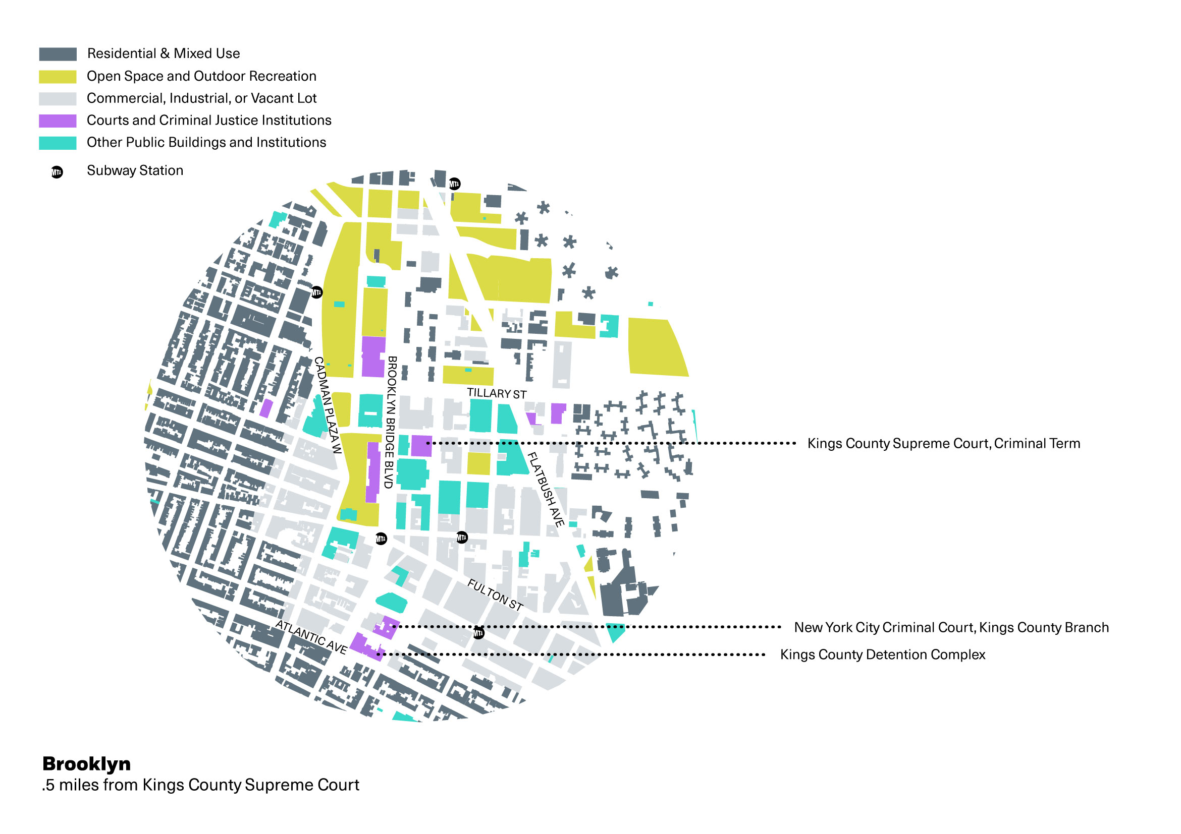
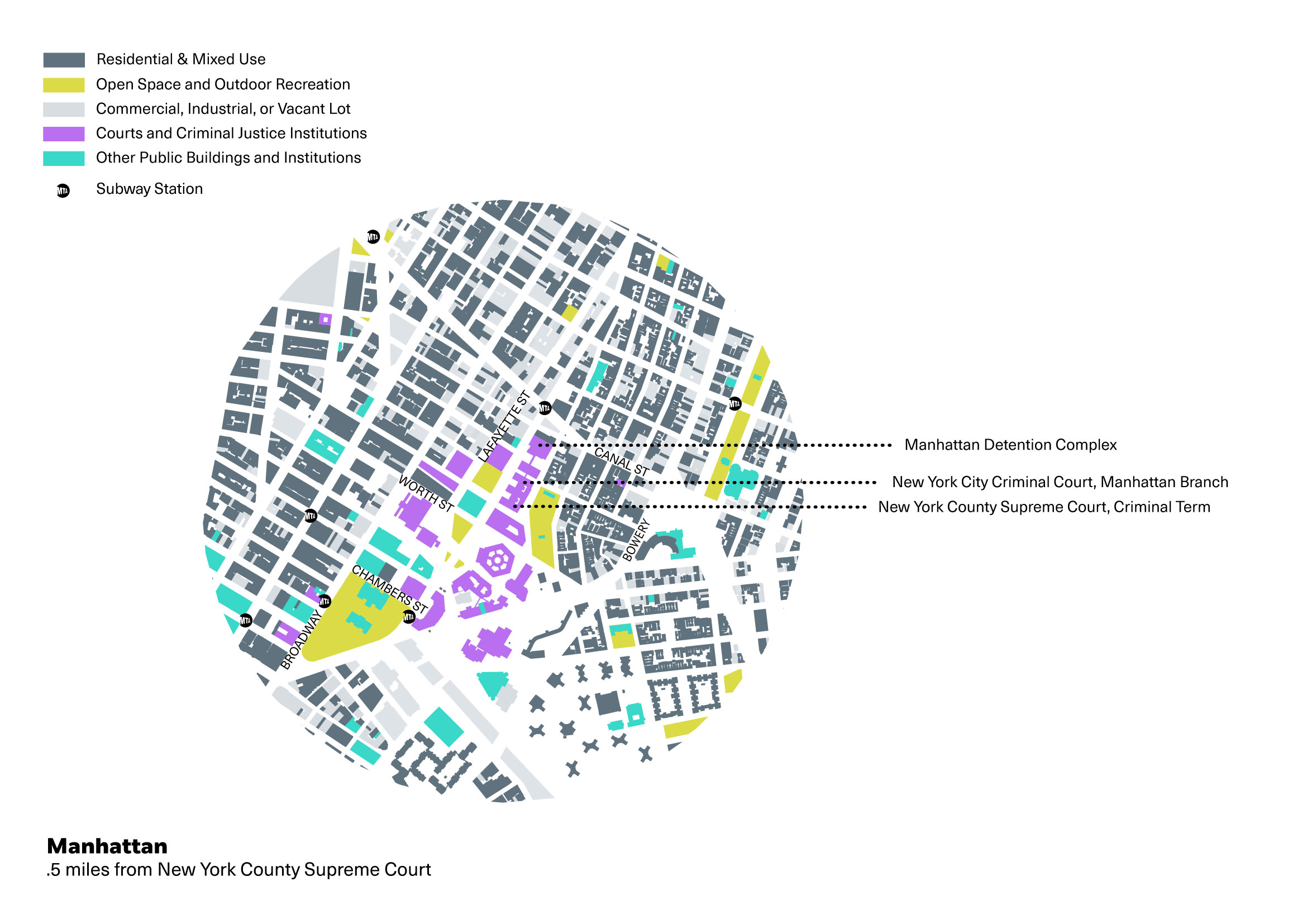
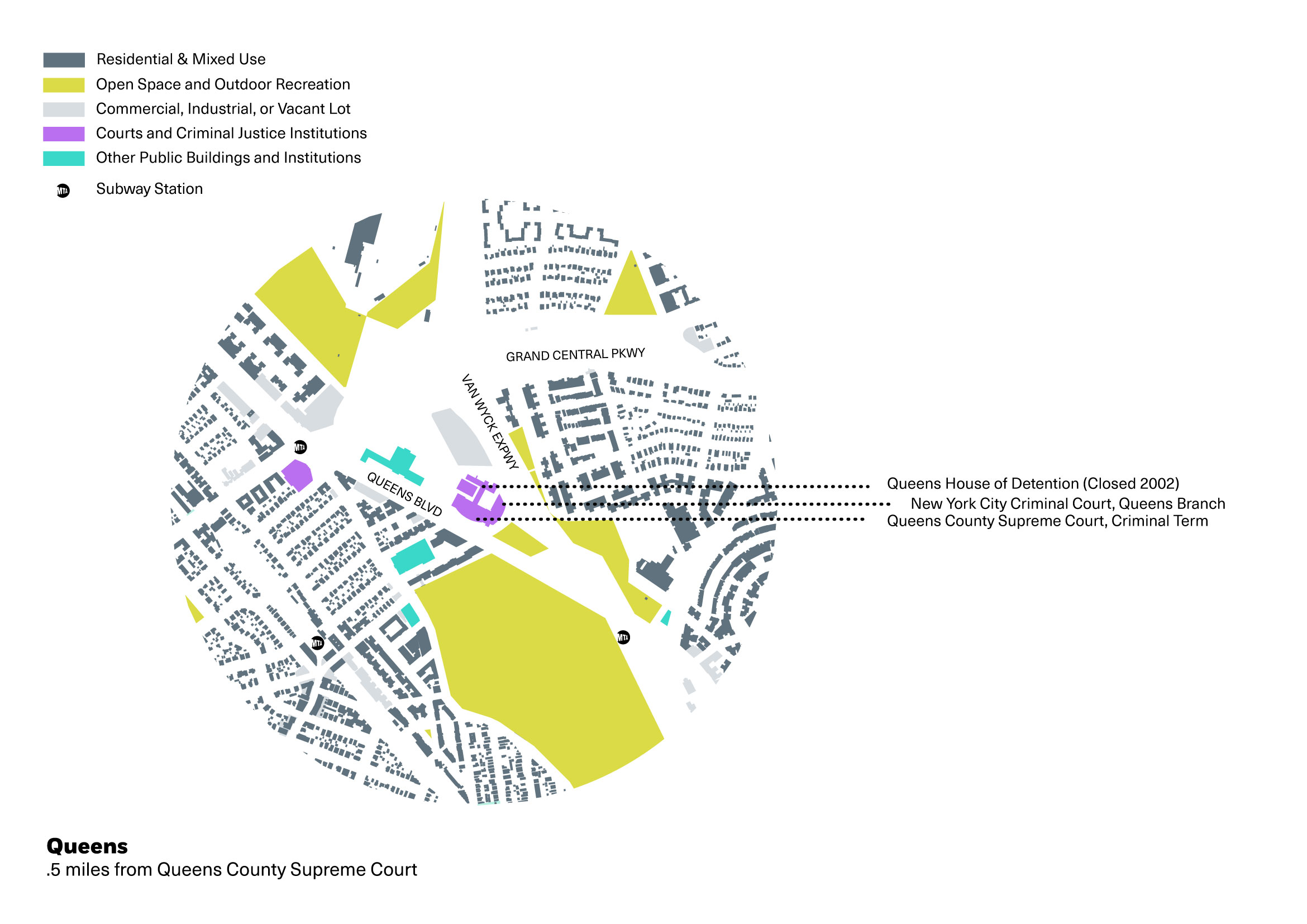
With such an approach on the table, we’ve honed in on the city’s “civic centers” and their neighbors. In the introduction to this series, we mapped the extent of criminal justice facilities across the entire city. Plotting a half-mile radius from each borough’s criminal courthouses (for ease of access for attorneys and visitors, and the smooth transfer of detainees — in Manhattan and Brooklyn, jails are connected to the court by a tunnel) the five maps below present neighboring land uses from playgrounds and condominiums to courts and existing detention sites. These drawings invite the viewer to consider: How will neighborhoods and communities react to a new, or expanded, jail in their midst? Even the broad prospect of neighborhood jails has already stoked NIMBYist indignation, particularly during last year’s mayoral campaign. The city’s “civic centers” are in fact interwoven with residences; how would the new structures change the fabric of these areas? What would jails have to be — and look like — to make a smooth transition? In slotting jails into city blocks alongside schools and parks, bus stops and shopping strips, can incarceration be radically changed, and meaningfully integrated into the texture of daily city life? Can it become fairer, less violent, more humane? And can jails come to be accepted as a visible part of urban life, by a city motivated to do things differently?
Update (March 8, 2018)
On February 14, Mayor de Blasio, accompanied by City Council members from Queens, Brooklyn, Manhattan, and the Bronx, announced the selection of four sites for new jail facilities. Intent on moving forward quickly, the Mayor and Council also announced that the City will carry out a single Uniform Land Use Review Procedure (ULURP) process for all four sites. Architecture and planning firm Perkins Eastman was awarded a $7.6 million contract at the end of January to create a master for the four sites. The firm will bring together 17 subcontractors, with 15 planning, engineering, and architecture firms (including Ricci Greene Associates), the Osborne Association, and community engagement consultants Fitzgerald & Halliday.
In Manhattan, Brooklyn, and Queens, the selected sites currently house operating or former jail facilities. As expected, nothing will be built on Staten Island. In the South Bronx, the proposed jail will be completely new. Some Bronx residents have already denounced what they see as a unilateral decision made by the Mayor and City Council without input from the neighborhood and without regard for the South Bronx’s history of being used as a “dumping ground” for waste treatment and industrial food transport. Bronx Borough President Rubén Díaz, Jr., also protested his lack of input into the decision. City Council member Diane Ayala, representing Mott Haven, endorsed the placement, and promised to work for “a robust community engagement process” as the plan moves forward.
Update (March 8, 2018)
The lot earmarked for a detention facility on East 141 Street in Mott Haven is the site of the former Lincoln Hospital, demolished to make way for a (still operating) NYPD tow pound. Unlike the other proposed facilities, located in the “civic center” of each borough, the proposed Bronx site is 20 blocks south and east of Bronx Hall of Justice and associated institutions and supports. The lot is sandwiched between residential townhouses and the industrial corridor of the Bruckner Expressway.
Max Scoppettone drew the maps based on an earlier version by Nishant Jacob and Stella Ioannidou, with additional research by Olivia Schwob. Data used for maps was drawn from NYC OASIS, DCP Capital Planning Platform Facilities Explorer, NYC Open Data, NYC DCP PLUTO, Google Maps, and our Map: The Location of Justice.
The views expressed here are those of the authors only and do not reflect the position of The Architectural League of New York.
An examination of the pervasive and often overlooked infrastructure of criminal justice in New York and the spaces that could serve a more just city.
In This Series
Comments