
We are celebrating 15 years — and counting — of stories that are deeply researched and deeply felt, that build a historical record of what the city has been.
We are celebrating 15 years — and counting — of stories that are deeply researched and deeply felt, that build a historical record of what the city has been.
In recent years, many New York City neighborhoods have witnessed the transformation of their former industrial waterfronts into lucrative residential and commercial real estate. Fortunately, the city’s zoning code — which helped pave the way for this spate of development — ensures that private property and public interest are balanced through the creation of new waterfront recreational areas, accessible to all. There is no shortage of mandates related to the design of these de facto public spaces: from the minimum soil depth of turf grass, to the lettering of the words “OPEN TO PUBLIC” printed on carefully-located signage.
But there is a glaring omission sitting at the heart of this regulatory landscape: climate resilience. During the seven years following Hurricane Sandy, the Department of City Planning (DCP), along with other city and state agencies, has promoted a number of detailed guidelines for mitigating the effects of rising waters and storm surges. Yet so far, these proposals have not made the leap from recommendation to law, ultimately leaving the onus on individual private developers to prepare for a threat that requires coordination across property lines. As DCP continues to hone its new Comprehensive Waterfront Plan (to be released at the end of 2020), landscape architect Sanjukta Sen asks why truly resilient waterfronts remain a best practice, and not a wholesale requirement in the face of the climate crisis.
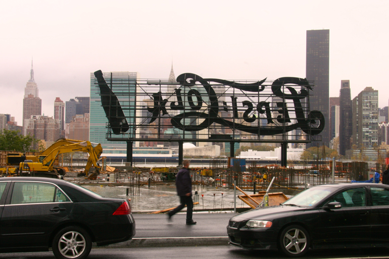
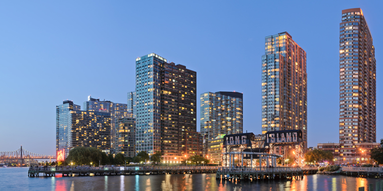
In New York City, the mega-event that didn’t happen in 2012 shaped our waterfront more dramatically than the one that did. The city’s failed bid for the Summer Olympics catalyzed a rezoning and subsequent development boom along shorelines that had been identified as potential sites for stadiums and residential facilities — particularly in neighborhoods along the East River such as Long Island City and Williamsburg. The resulting building boom in these areas remains untempered to this day, despite the landfall of Hurricane Sandy — a one-in-700-year storm which has profoundly reshaped the conversation around the city’s response to climate change. All of the drenched imagery and apocalyptic statistics which followed in Sandy’s wake haven’t impacted the pace of development in a city that must seemingly grow at any cost. New York’s pugnacious approach to its unique vulnerability in the face of the climate crisis is, to a large extent, the legacy of the Bloomberg administration, which strategically — at least in terms of its messaging — blended a call for coastal resilience with an aggressive development agenda on the waterfront.
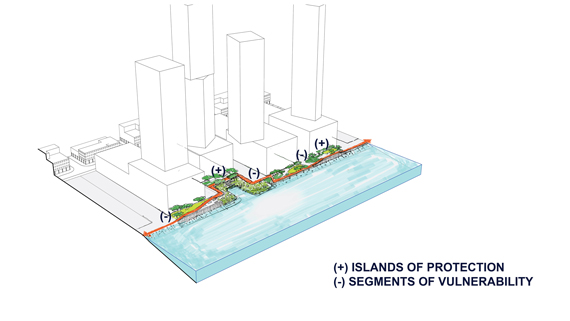
In the years following Hurricane Sandy, I have observed — and in my professional capacity, participated in — the enthusiastic development of the city’s East River waterfront with a strange blend of pride and bewilderment. These developments have unlocked new, public recreational venues in neighborhoods that had been cut off from shorelines by reclaimed lands, infrastructure, manufacturing, and industry. But while the aesthetics and quantity of waterfront public space have garnered a fair amount of regulatory attention, resilience efforts remain largely unmandated, tacit, and voluntary at best. And where individual developers have adopted resilience measures, the unevenness of such efforts has been criticized for producing “islands of protection” that displace flood risks onto neighboring areas, producing new segments of vulnerability.
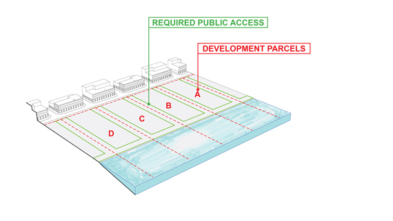
Despite the increasing awareness and acknowledgement of climate change, accompanied by a higher recurrence and likelihood of coastal storm events, “resilience” is a relatively new entrant in New York City’s regulatory lexicon. For more than 25 years, transactional regulations between the city and private developers building on the waterfront have focused on areas of public access and, more recently, affordable housing. Interestingly, the stated goal of New York’s first waterfront zoning resolution in 1993 was to discourage “megaprojects“ and encourage “reasonably scaled projects with public access on the waterfront.” Without being specific about where they would apply, this targeted rezoning set out rules requiring developers of large projects to provide 15 to 20 percent of their waterfront land for public access.
While retaining these basic rules, subsequent amendments and rezonings (such as the massive 2005 rezoning of 37 percent of the city under Mayor Bloomberg) enabled the construction of 10,000 units of high-rise housing along the waterfront — and, in acquiescence to community demands, tacked on additional incentives for affordable housing and provisions for even greater public access. In 2009, a zoning text amendment was incorporated into these mandates to set design standards that would “ensure that the city’s waterfront spaces are accessible and inviting to the public, feature high quality design elements, and promote greening of the waterfront.” These entailed granular regulations regarding paving surfaces, quantities and types of seating, amount of planting and lawn area, trees, lighting, and more.
Although there has been a significant increase in availability of affordable housing and public space, it’s necessary to look beyond the appealing new amenities on the waterfront and ask ourselves some hard questions. Are we effectively addressing coastal resilience? Or are we making waterfront communities more vulnerable? Why are we ending up with these islands of protection and segments of vulnerability? Why aren’t all waterfront open spaces doing what they should logically be doing — working as the first line of defense against coastal hazards? As a city that has opted to develop our way out of this problem — and that’s certainly what it looks like from the compulsive invitations and inclination to develop in the 100-year floodplain — shouldn’t we find a way to make our waterfront landscapes perform as essential infrastructure for coastal resilience?
This is hardly a novel idea. The last few years have seen a deluge of well-funded, landscape-based coastal resilience strategies and comprehensive plans, such as Rebuild by Design (New York and New Jersey), Resilient by Design (San Francisco Bay Area), and Resilient Harbor Vision (Boston). Cities are beginning to adopt these types of strategies as the basis of future policymaking. But while such plans have seen moderate success in terms of implementation where capital projects are concerned, the damaging slow walk has been on how to comprehensively overhaul regulations that govern private development in the flood zone — which comprises a considerable share of New York City’s 520-mile coastline.
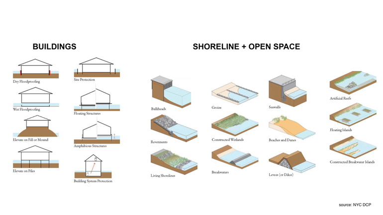
After Sandy, New York and storm-struck cities in neighboring states moved fairly quickly to adopt new building codes to minimize the damage of flooding from future storm events. In 2013, a flood resilient zoning text was introduced to “enable and encourage flood resilient building construction in designated flood zones.” Today, developers working in flood zones are required to elevate their buildings above the anticipated water level during a once-in-100-year storm. But regulatory frameworks have been myopic when it comes to open space around raised buildings. The singular mandate to raise buildings has been accompanied by a dozen well-intentioned and thoroughly researched guidelines, toolkits, and checklists for waterfront developers, issued by agencies such as New York City’s Department of City Planning (DCP) and Department of Parks and Recreation (DPR), and the state’s Department of Environmental Conservation (DEC). These documents “recommend,” “advise,” and “ask” that developers build floodgates and levees, create wetlands and barrier islands, and elevate surrounding land to address flooding and erosion. But these suggestions are non-binding — it’s ultimately up to developers to decide whether or not they want to invest in site adaptation and mitigation measures that go beyond the minimum requirements for providing public access, benches, and trees.
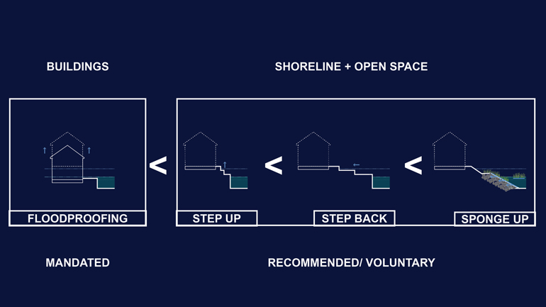
Though building-related measures are the only ones mandated by the city, the voluntary toolkit of site resilience measures (in the somewhat constrained contexts offered by urban shorelines) can be categorized in order of escalating effectiveness: Step Up, Step Back, and Sponge Up. Step Up, or elevating the site, is the most prevalent measure, which most developments incorporate because access must be provided to and from raised buildings. The next threshold is Step Back, a sort of micro-retreat — rarely volunteered because it means giving up developable site area. There is no regulatory instrument that can require a resilience setback; rather a developer can be given incentives in the form of transferable development rights elsewhere or permission to build taller. The third category is Sponge Up: adaptation and mitigation measures that not only provide protection, but are also geared towards improving the ecological condition of the water and the shoreline. These latter two interventions are rarely volunteered because of the space they occupy and the time sink of regulatory and jurisdictional hurdles that have to be crossed to get these measures permitted.
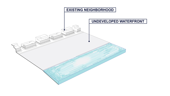
In the typical process of private waterfront development, tracts of land in the floodplain, previously allocated for industrial and manufacturing uses, have been rezoned for residential and commercial use.
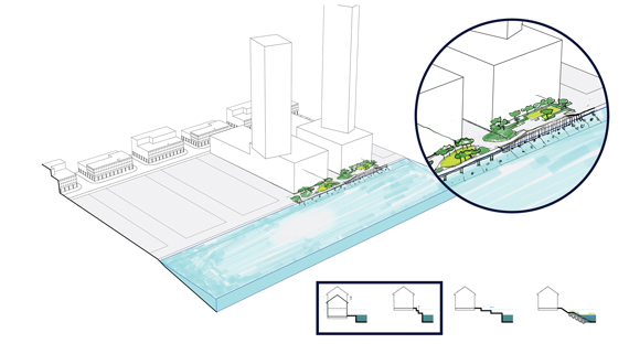
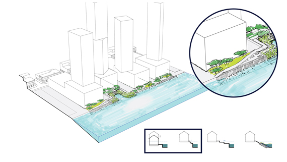
According to existing regulatory frameworks, buildings in the floodplain must raise dwelling areas and essential infrastructure above the Federal Emergency Management Agency’s designated flood zone (left). The Step Up strategy for site elevation, though not required, is the voluntary measure most often adopted by developers (right).
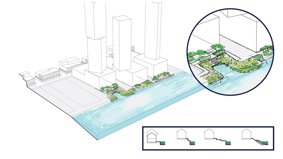
Resilience strategies such as Step Back and Sponge Up (left) are also voluntary, but less commonly implemented. Along urban waterfronts, a landscape of uneven resilience is created through the different choices made by owners of individual properties.
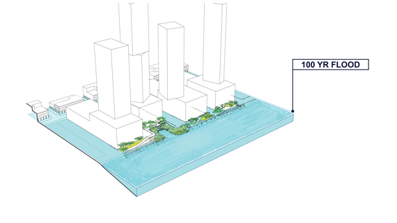
In the face of a 100-year flood (right), uneven resilience measures along the waterfront lead to a situation where “islands of protection” can displace floodwater onto nearby segments of vulnerability. Images by Sanjukta Sen
The answer to why more effective resilience strategies are not required by law is potentially nested within the most publicly-appreciated component of all waterfront developments — shoreline access. Public access is already construed as a burden or a “taking” from private developers, despite the demonstrated economic value it adds to the development (especially in a city like New York). While it’s high time that parameters of resilience performance are integrated into the regulations that govern the provision of waterfront public areas, our city and state agencies have been reluctant to go there, perhaps because it may be perceived as an additional burden or deterrent to further development.
It is also crucial to align agencies that exercise authority on development in the floodplain, both in terms of specific regulations and overall mission. Various aspects of New York’s tidal waterfront are regulated at the federal level by the US Army Corps of Engineers (USACE), at the state level by DEC, and at the local level by DCP. The role and mandate of all of these governance agencies has to be recalibrated to some extent if we want to make meaningful strides in designing our waterfront open spaces as infrastructure for resilience. Just as the waterfront zoning resolution administered by DCP has not been able to expand its purview from the quantity and quality of public space to performance and resilience, the joint regulatory framework of the DEC and USACE has not been able to truly extend its role beyond policing the quantity and quality of fill in the city’s waterways, and safeguarding against coastal creep. All three agencies are limited by the fairly narrow and defined parameters set by outdated mandates. As a result, propositions that push the envelope — comprehensively addressing resilience, ecological benefit, and development — are far and few in between, and seen as unicorns rather than replicable models to be emulated.
In the context of New York City, the opposition is no longer between less and more development. It is between piecemeal, ad hoc development practices and comprehensive resilient development practices. Shorelines hardened by sea walls or jetties, while discouraged by well-meaning mission statements from various agencies, appear to be more convenient as far as permitting is concerned, and therefore more prevalent in practice — despite the limited performance value of, and ecological damage caused by, these structures. In effect, as long as there is a park that meets and maximizes public access, it’s deemed sufficient. The narrow focus on square footage of new open space is surely, however, a dated premise that (while necessary) is no longer sufficient.
Existing regulatory frameworks have created a resilience “non-strategy” that delegates decision-making to individual developers. But infrastructures that enable meaningful and effective coastal resilience strategies need physical space and continuity across ownership and jurisdictional boundaries. It is incumbent on city, state and federal legislative authorities and leadership to foster agreements across property lines, and ensure that mitigation and adaptation measures — such as increasing a site’s volumetric capacity, and provision of surge protection and ecosystem services — become encoded into forthcoming plans, policies, and development frameworks as requirements, not suggestions. Both the technical and regulatory feasibility of most of these best practices have already been extensively studied and advocated for by academics and activists. Knowledge development and pedagogical outreach by groups such as the Association of State Flood Plain Managers (ASFPM), the Regional Plan Association (RPA), and the Waterfront Alliance have taken the forms of model legislation and resilience scorecards. These efforts have been accompanied by growing clarion calls to reform insurance practices, and the formation of multidisciplinary task forces to pave the way for regulatory reform.
In 1916, New York became the first city in the US to pass a zoning resolution: a regulatory instrument that was held up as the exemplar of balancing private interest with public good. The institution and evolution of New York City’s zoning regulations have had a great influence — beyond impacting its own residents. For better or for worse, development practices and regulatory instruments deployed in New York are observed and emulated around the world in cities of comparable density, with similar development pressures and vulnerabilities. The nature of climate-related hazards we face requires a new approach to development of private property on the waterfront — a shift of mindset from maximizing individual benefit to minimizing community and neighborhood risk. If we want to sustain the profitability and benefits of being a waterfront city, along with the responsibility of being an urban role model, we need to acknowledge the urgency of including resiliency in the regulatory frameworks that govern waterfront open spaces.
The views expressed here are those of the author and do not necessarily reflect the position of James Corner Field Operations.
The views expressed here are those of the authors only and do not reflect the position of The Architectural League of New York.

