
We are celebrating 15 years — and counting — of stories that are deeply researched and deeply felt, that build a historical record of what the city has been.
We are celebrating 15 years — and counting — of stories that are deeply researched and deeply felt, that build a historical record of what the city has been.
#whOWNSpace: An Introduction
by Jessica Cronstein
The occupation of Zuccotti Park unintentionally brought attention to the nebulous rules that govern New York City’s privately-owned public spaces (POPS). In 1961, the city was changing. Advances in building technology meant office towers could be built higher than ever before, and developers had an interest in making use of this additional square footage. A revision of the zoning laws offered a trade: in return for creating public open spaces — perhaps most importantly, for the Occupy Wall Street movement, spaces “accessible to the public at all times,” unlike city parks which close at dusk — the developers would be allowed a higher floor-to-area ratio (FAR). The idea was to allow for more light and air in dense, vertical areas, and to have developers give back to the city a little bit for what they were gaining by building bigger. The rules governing the design of the POPS, though, were incredibly vague, which led to the creation of inaccessible, inhospitable spaces with little or no public benefit. Revisions were made, including requirements for shade trees, seating and lighting, and zoning amendments were added, allowing owners to apply for permission to close the spaces at night. But still, the laws dictating the management and use of these spaces are vague, and often come down to unspecific semantics.
To address questions of ownership and use of open space in New York City, members of Not an Alternative, DSGN AGNC and DoTank: Brooklyn launched the project #whOWNSpace. Their stated intention is to reveal and question conflicting rules and ownerships of public space, advocate for and propose uses and designs in accordance with their Call to Action for the Rights of Neighborhoods, and to turn ideas and research into material action through intervention in urban space. Earlier this month, the collaborative partnered with The Public School New York to hold a class, in three locations simultaneously, that investigates power dynamics in urban open space.
The class visited three neighborhoods: the Financial District, Midtown and the Upper East Side. Each section was given two public spaces to visit, observe, diagram and discuss. Afterwards, all groups convened in midtown to share ideas and results.
#whOWNSpace: Financial District
by Mercedes Kraus
Guided by Rena Mande and Amanda Rekemeyer, DSGN AGNC collaborators, my class walked through the western part of the Financial District.
The route took us from Battery Park City ballfields (a well-maintained, pay-to-use, privately managed public park) to the Goldman Sachs World Headquarters (no POPS), a park at 7 World Trade Center (a new POPS with a Jeff Koons sculpture, funded by the 9/11 recovery monies), 101 Barclay Street (an indoor POPS, as listed by the city, that in reality doesn’t exist) and, finally, to two publicly-owned open spaces (POOS): Washington Market Park and Duane Park.
Our stop at the Goldman Sachs HQ was particularly interesting. Because the firm received extra incentive from the city to stay in the Financial District after 9/11, the only “public benefit” the fortress-like building gives is a mural inside its lobby, to be viewed from the outside, on a sidewalk only for walking (security guards ensure that no other activity takes place).
Upon arrival at the small plaza adjacent to WTC-7, closed by the owner and barricaded by the NYPD (for fear that OWS might occupy it), we mapped the POPS, observing lighting, seating, use, access, etc. Sarah Williams, of the Spatial Information Design Lab, introduced us to the idea that “maps allow us to read places in a different way … mapping is marking reality but also how you observe reality.” I did, in fact, feel more engaged with the levels of meaning and use of the space once I had marked it and also looked at the markings of my peers. Making maps, then, serves as means of conversation, for which reason #whOWNSpace will soon launch an open-sourced map of NYC POPS and POOS on the project’s website.
When we left the tall towers and regulated POPS of the WTC area, we visited Washington Market Park, which, besides having one small, slightly hidden entrance and a short list of rules (its own form of security), is a rather large space designed and used for diverse activities. It has a large playground, public bathroom, pavilion, and community garden, and I felt more welcome here than at any other site the class visited. Our last stop of the day was Duane Park, also a POOS. No rules were posted regarding use or hours, and most of the (small) walkway was lined with good benches, making it a good, though simple, public space.
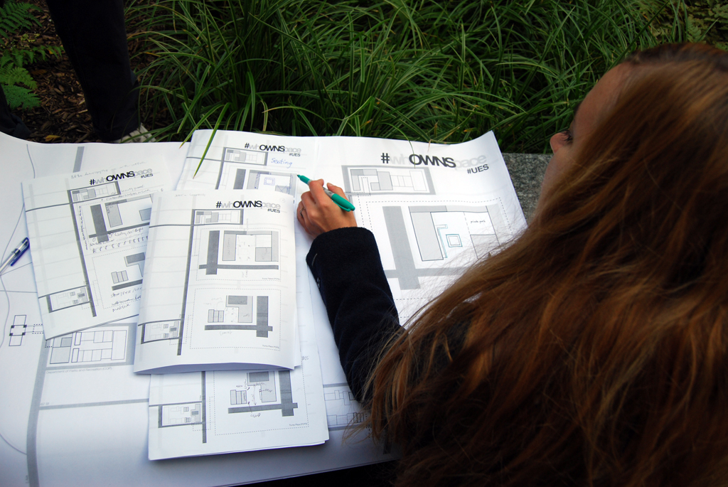
#whOWNSpace: Upper East Side
by Jessica Cronstein
My group met in front of the offices of the New York City Department of Parks and Recreation at 64th Street and Fifth Avenue, where we were given blank maps with inset plans of the two spaces we were to visit (both Trump buildings). Each member chose one element to diagram while at the sites: access, edge conditions, seating, lighting, activities, signage / graphics, design / branding, circulation or demographics.
Our first stop, the public space attached to Trump Palace, was designed to appear as part of the building, giving passers-by the impression that it is only for residents. The gates that demarcate the space — beige-painted metal, not likely to be part of the plaza’s original design, which is predominantly marble — seem to be permanently closed. The plaza looks, from the outside, like a maintenance entrance for the building. The space is shady, which, in November, means cold seating. While there, though, we saw it used by a group of construction workers eating their lunch and an elderly woman who stops in every day on her walk through the neighborhood.
The second space we visited, Trump Plaza, feels like an extension of the lobby of the building. It is directional and ends at the main entrance to the building. Some of the problems are the same as before: cold seating in a shady plaza, and a feeling (amplified by the watchful eye of the nearby doorman) that you need an invitation to use the space.
The problems built into these two spaces were problems of management and design: they were designed to be uninviting, to feel like private spaces for the residents of the towers above. The beauty of the small parks that exist only blocks away is that they are rarely crowded and are perfect lunch spots. But they will never have the identity of a full-fledged park. They are always associated with the building or the block. In the residential neighborhood of the Upper East Side, the character and expectations of the spaces were different than those of Midtown and the Financial District.
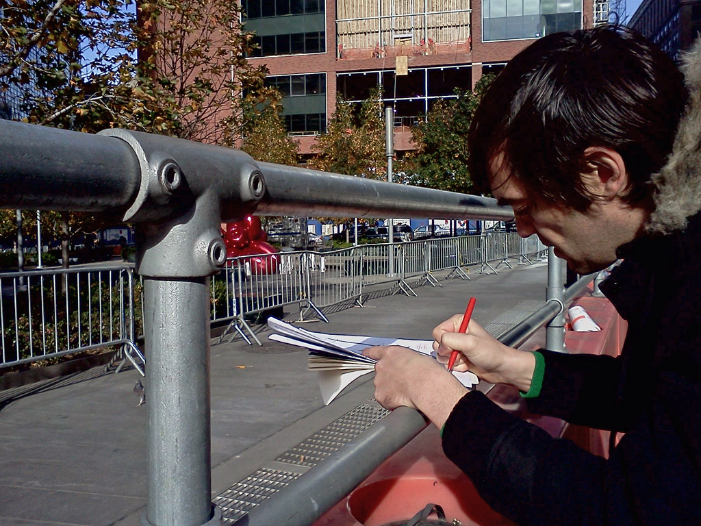
#whOWNSpace: Midtown
by Max Podemski
Amidst businesspeople, tourists and a pair costumed as Shrek and Elmo at the northwest corner of Bryant Park, my group met Quilian Riano, an urban design professor at Parsons and co-founder of design collective DSGN AGNC, and Phillip Grimaldi, a designer and also a member of DSGN AGNC.
Before the class even began a security guard demanded that Quilian take down a poster taped to a sign for the Citi Pond Ice Skating Rink. This is “private property,” the guard told us, who then proceeded down to the corner to kick out Shrek.
The current incarnation of Bryant Park is the result of a Project for Public Spaces (PPS)-led renovation in 1981. However, rather then finding a vibrant, democratic, public space, our group found a park that more closely resembles a rotunda inside a mall. Every usable inch of the park has been programmed, ranging from ping pong tables to corporate marketing tents to a New York-themed tchotchke bazaar. The pure domination of the space by monetized interest leaves little room for its use as a democratic public commons.
After visiting Bryant Park, ostensibly a publicly-owned private space, we visited several privately-owned public spaces or POPS. The first “covered pedestrian space” we examined was in the Phillip Morris building at 120 Park Avenue. At one time this space housed a Whitney Museum affiliated sculpture galley. Today it is an antiseptic room, reminiscent of an extremely luxurious DMV office. A guard at a flimsy desk stood watch over the three people sitting at tables in the plaza, which is sunken below the lobby of the building that looks down on the space through enormous windows — a panopticon, one participant called it. The consensus of our group was that this was, by far, the creepiest of the POPS on the tour.
The second stop was the Grace Plaza on 43rd Street. This outdoor space is connected to the W.R. Grace Building, named after a chemical company famous for its more than 200,000 asbestos-related lawsuits. In spite of two qualities often associated with successful public spaces, moveable chairs and a programmed use via a small gallery for the International Center for Photography, our tour still found many flaws in this plaza such as the open, windswept nature of the space and the cold hard material of the oddly-configured seating area.
The third and final of the POPS we visited was affiliated with the 1095 Avenue of Americas Building, which recently underwent an extensive renovation. Rather then occupying the front of the tower facing Bryant Park, this plaza is sequestered behind it, lying in a narrow canyon between the massive buildings of midtown. Pleasant wood benches stand in rows facing small trees. However, flanking the entire east side of the plaza is a large window looking into the lobby of the tower, in the center of which sits a guard who soon came out and ordered one person in our group not to stand on a bench. With that, our investigation of who owns space in midtown concluded.
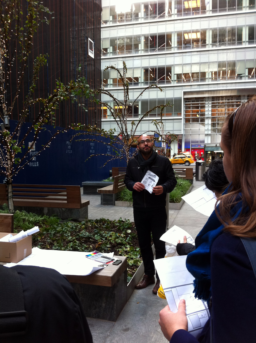
#whOWNSpace: Wrap-up Session
by Jessica Cronstein
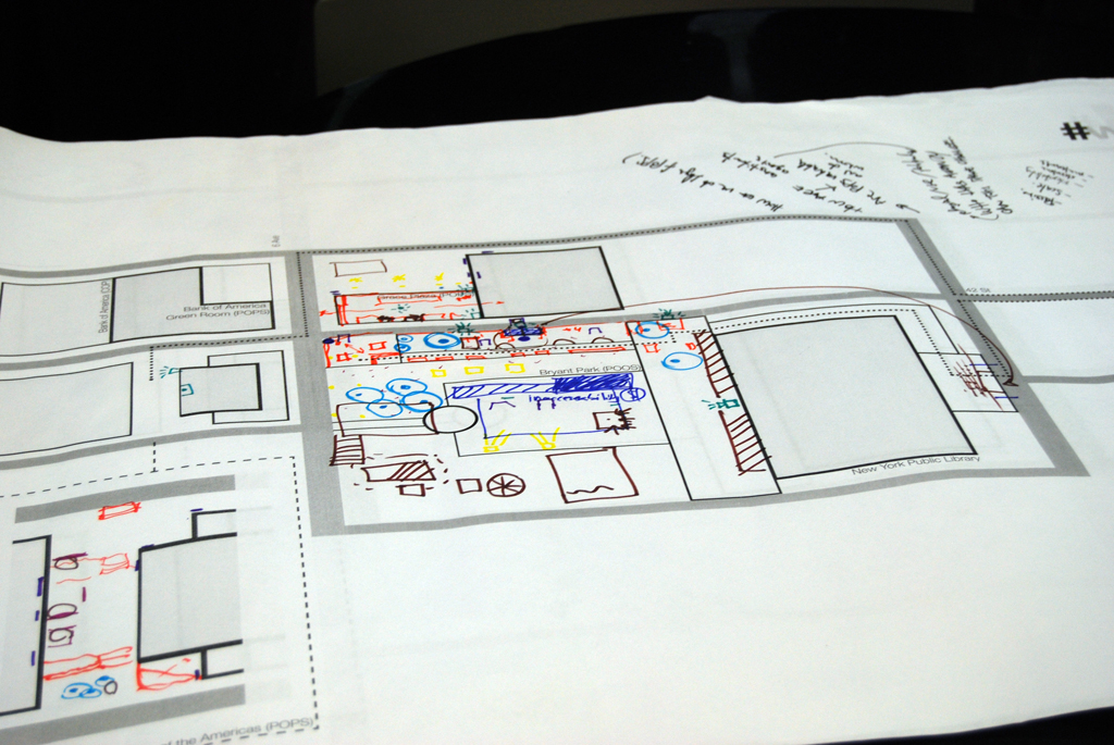
At the end of the day, the three groups converged on the Verizon POPS between 41st and 42nd Streets, east of 6th Avenue, before moving to another POPS, the Philip Morris covered pedestrian space at 42nd Street and Park Avenue. We compiled our research to create a master map, and representatives from each group shared their diagrams and described the qualities of the spaces they visited.
The characters of the three neighborhoods became apparent. In the Financial District, the management of each space was on red alert, security guards were conspicuously present, looking out for another Zuccotti Park incident. These POPS are designed to be shortcuts, they aren’t meant to be oases within the city. In Midtown, the plazas are interior spaces or between buildings, used differently by two distinct demographics: office workers during the week and tourists during the weekend. They are more conducive to enduring visits, but are still less than welcoming. On the Upper East Side the plazas are attached to residential buildings, giving the appearance of more privatized ownership.
Who were these spaces designed for? And how were they designed to be used? What constitutes the public? What is the value of small public space? And to whom? What are the rights of the management? And how do they infringe on the rights of the public? The questions raised by #whOWNSpace are ones the city has contended with for 50 years, and will continue to for years to come. They won’t be answered in one afternoon.
Correction: an earlier version of this article referred to the Battery Park City ballfield as a POPS, when in fact it is a POOS, or privately owned open space.
The views expressed here are those of the authors only and do not reflect the position of The Architectural League of New York.


Comments