We are celebrating 15 years — and counting — of stories that are deeply researched and deeply felt, that build a historical record of what the city has been.
We are celebrating 15 years — and counting — of stories that are deeply researched and deeply felt, that build a historical record of what the city has been.
Climate resiliency in New York City often appears as a gargantuan affair: ten-mile long berm systems; visions of draining the East River; the classic seawall, reimagined. Thinking at the scale of infrastructure is crucial for matching efforts to the scale of the crisis itself. But infrastructure is not just physical. Across the city, from Red Hook to the Lower East Side, neighborhoods have planned for climate disasters by building what sociologist Eric Klinenberg calls “social infrastructure.” So when the Department of Parks and Recreation approached Starr Whitehouse Landscape Architects and Planners and ONE Architecture & Urbanism to help develop a resilience plan for East Harlem, engaging local residents and institutions would be as important (and more immediately actionable) as costly designs for stormwater management or coastal protection systems. One pilot project launched during the year-long study has driven this point home: an experiential learning program, co-created with DREAM Charter School, called the Climate Resilience Leadership Lab. Now in its second year, the Lab provides a replicable model for resilience education, producing a full-semester curriculum and emergency preparedness guide grounded in the conditions and assets of East Harlem. Below, Michael Haggerty of Starr Whitehouse and Emily Parkey of DREAM Charter School describe the Lab’s development, and how it is enlisting neighborhood youth in helping lead the “intergenerational proposition” of resiliency.
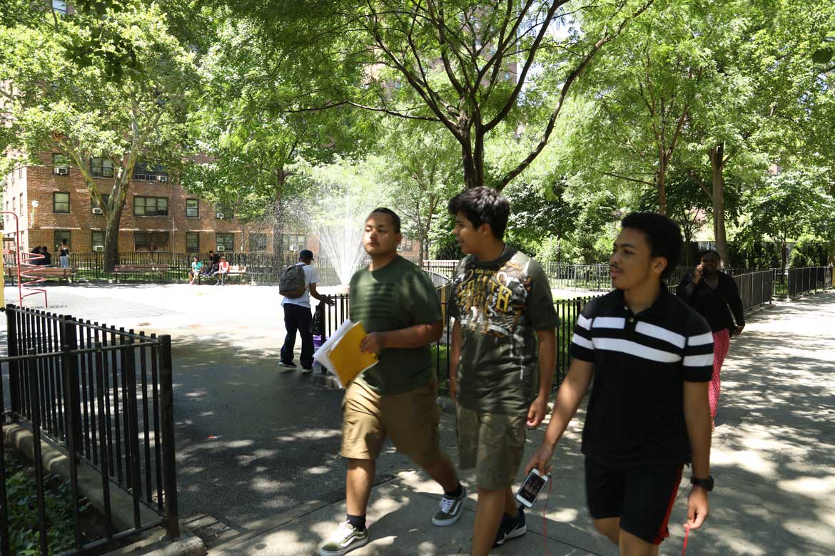
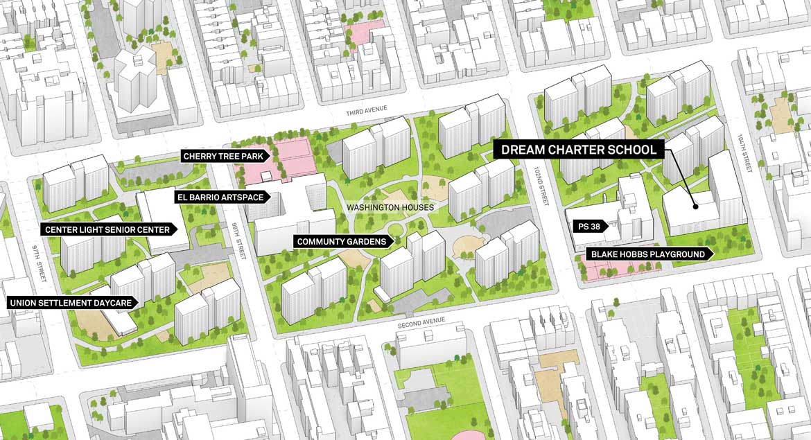
If you exit the subway at 103rd Street in East Harlem, you may be surprised to find yourself on the kind of steep incline New Yorkers more typically encounter in the Bronx. Looking down Lexington Avenue, the street rises swiftly, disappearing from view at the 102nd Street intersection, where this particular outcropping, known as Carnegie Hill, peaks. Heading east along 103rd Street, you will walk down a gentle hill until you reach George Washington Houses at Third Avenue, a New York City Housing Authority (NYCHA) development comprised of 14 towers built on three “superblocks” from 97th Street to 104th Street. The ground here appears to flatten out; but go a little further into the superblocks, and you will find a snail-shell shaped path spiraling towards a central lawn where tenants have installed a few garden boxes. The path’s sweep has a subtle downward slope that traces a topographical depression in the center of the complex.
Before the city’s grid extended from the Battery to the northern tip of Manhattan, this part of the island was mostly a salt-water marsh, with a large stream called Harlem Creek running where 108th Street is today. In other low-lying areas of Manhattan, where these historic marshes were filled in, the vestiges of wetlands are now known as the 100-year floodplain — areas with a one percent chance each year of being inundated during a hurricane — and in East Harlem, the floodplain forms a loose triangle bounding the neighborhood’s low ground. Although inundation in East Harlem during Superstorm Sandy was relatively mild compared to the devastating surge on the Lower East Side and in Red Hook, a future storm of similar magnitude coming from a different direction or at another time of the tidal cycle could have a severe impact on the neighborhood.
In 2017, Starr Whitehouse Landscape Architects and Planners and ONE Architecture & Urbanism were hired by NYC Department of Parks and Recreation to create a climate change resiliency study for East Harlem — one of several plans that New York City agencies have undertaken in the last six years to assess climate risks and design infrastructure to protect neighborhoods from hazards like coastal storm surge. While resiliency planning in New York City has, for the most part, focused on Sandy-like scenarios, these studies are increasingly taking a wider perspective on climate change risks. “Cloudbursts” — short rains dumping huge volumes of water — will result in localized flooding at low points like the one in Washington Houses. Heat waves are another risk, especially in neighborhoods like East Harlem where the street-tree canopy is sparse, and where many people live in housing without air conditioning. Moreover, as climate change risk becomes better and more broadly understood across New York City, the variety of stakeholders engaged in climate resilience planning must widen. The team was therefore tasked both with designing infrastructure to take account of these broader risks, and creating a process for engaging with community groups and neighborhood institutions, many of which have been working to increase climate resilience in the six years since Sandy.
To address climate risks, our team considered how parks and public spaces could become multi-functional. If a playground was equipped with underground storage to address cloudburst flooding, could it also be renovated to become a community hub? If underground utilities were re-organized to make room for stormwater conveyance, could more space above ground be created for pedestrians, cyclists and public transit? The East Harlem Resilience Study, the result of Starr Whitehouse’s and ONE’s work with NYC Parks, compiles solutions like these into a larger strategy for addressing climate change risk in East Harlem while creating benefits for community members, such as enhanced parks and stronger connections to the East River waterfront.
But what does it look like for climate resilience to become rooted in a New York City neighborhood? In neighborhoods like East Harlem — where gun violence, hunger and disinvestment are daily realities — climate change may understandably be a low priority for some community members. Moreover, where funds are not yet committed for implementing resilience strategies, as is the case in East Harlem, a large-scale capital project such as a flood-resilient park might take up to 10 or 20 years to be financed, designed, constructed, and used by the public. In the meantime, what assets can community members look towards as examples of resilience taking form in the neighborhood? With these questions in mind, our team approached community engagement with a focus on the social dimensions of resilience: among other things, knowledge and awareness of climate risk; the strength of social connections that are important during and after disasters; and the fostering of advocates that can link neighborhood residents to systems of governance in times of crisis. Out of this framework emerged the Climate Resilience Leadership Lab, a partnership with DREAM Charter School — one local institution that offers a model for promoting resilience through education.
Located on the northwest corner of Washington Houses off of Second Avenue, DREAM is an example of what sociologist Eric Klinenberg (another member of our team) calls “social infrastructure”: physical places and organizations that shape social interaction. Social infrastructure is a valuable component of climate resilience because it creates channels through which information and resources flow within a community. If you regularly bump into your elderly neighbor at the local branch library, for example, you are more likely to check on them ahead of a storm. In many ways, DREAM has been building resilience in East Harlem since long before our study began. Not only is the school located on the Washington Houses property, but many families who live in the development send their children to school there. Each month, the school calendar includes potlucks, workshops, and celebrations. At a weekly morning “café,” parents can linger and talk with each other after they drop off children. As a community hub, DREAM centers the success of children’s education and family health, and our team’s hypothesis was that this school might offer a credible platform for engaging community members in a lasting conversation about climate change resilience in East Harlem.
Leveraging social infrastructure to build resilience is the premise of the Climate Resilience Leadership Lab, an experiential learning program that Starr Whitehouse and DREAM created during the East Harlem study in 2017, and which has been running for the past two years. We wanted to know what would happen if we engaged young people in East Harlem about climate change at their school. How could the team support students in becoming advocates for resilience in the neighborhood, and encourage them to take action through projects of their own? The resulting program consists of a curriculum taught over six months that builds broad awareness and understanding of climate risks and resiliency solutions. Students learn to observe their surroundings through the lenses of design, urban planning, engineering, and social research, using the built environment of their neighborhood as a primary source. As students progress through the curriculum and become experts in how climate change will affect the neighborhood, they are encouraged to speak in public about what they have learned. During the East Harlem study in 2017 and 2018, for instance, students shared their perspectives on resilience at community planning workshops. These types of workshops are usually led by professional designers, who offer technical perspectives on the impacts of climate change and how infrastructure is planned and constructed in the city. But the DREAM students add what professionals more often than not lack: a real perspective of what it’s like living or going to school in the community.
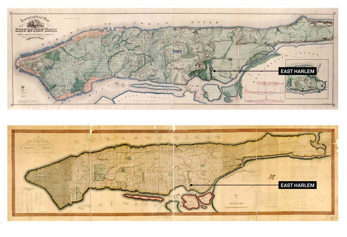
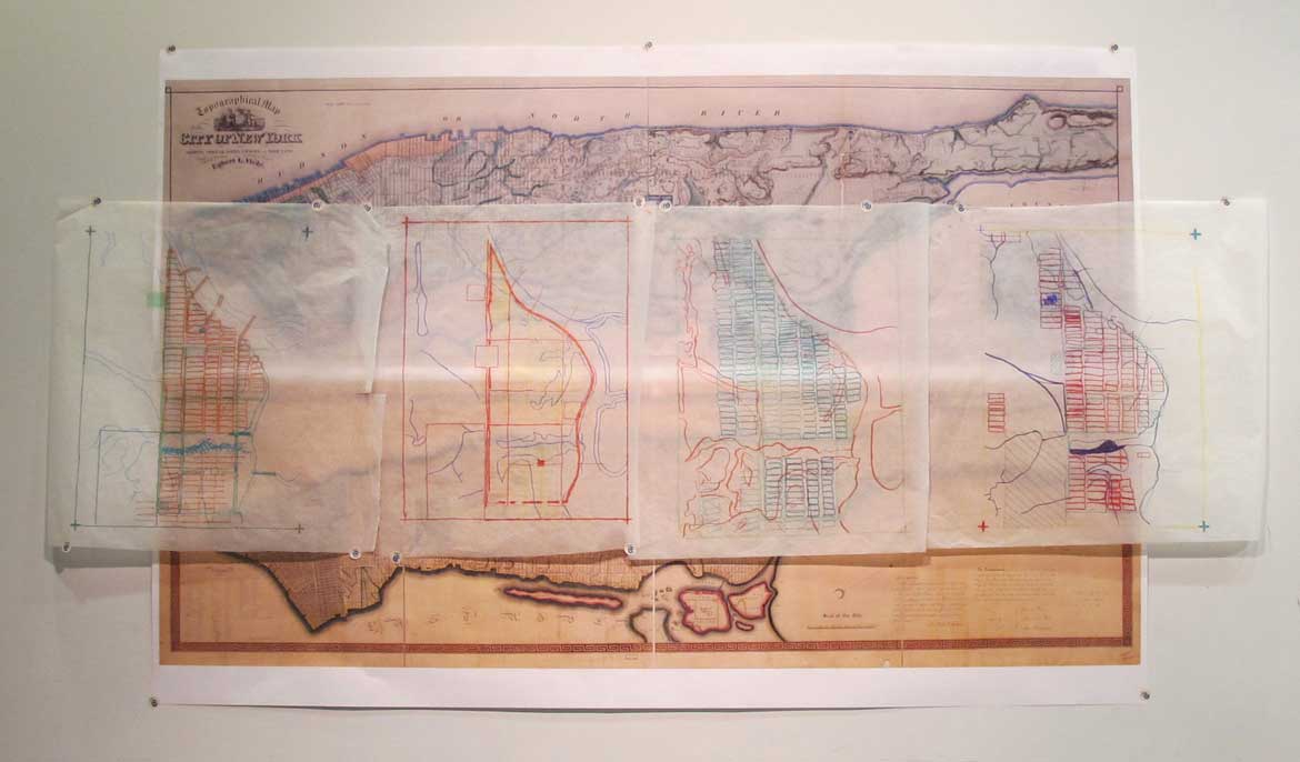
The East River is visible through the window in the classroom where the Climate Resilience Leadership Lab meets. During an early class session, we unroll old maps of New York City and look at how East Harlem’s relationship to the East River has changed over time. The students first decipher the 1865 Viele Water Map, which shows the waterways and marshes that striated “Mannahatta” before Dutch settlement in the 1600s. We then look at the Commissioner’s Plan of 1811, which introduced Manhattan’s urban grid, setting the stage for the eventual filling in of the waterways shown in Viele’s map and the transformation of the shoreline. Another map from 1954 shows an urban renewal plan for East Harlem, with hatched areas indicating where blocks within the Commissioner’s grid were consolidated as part of “slum clearance” to create the “tower in the park” public housing developments where some of the students live. Finally, students scrutinize a flood insurance rate map from the Federal Emergency Management Agency (FEMA) and the agitated line following the 100-year floodplain boundary, which roughly estimates the area that surge from a Sandy-like storm would inundate.
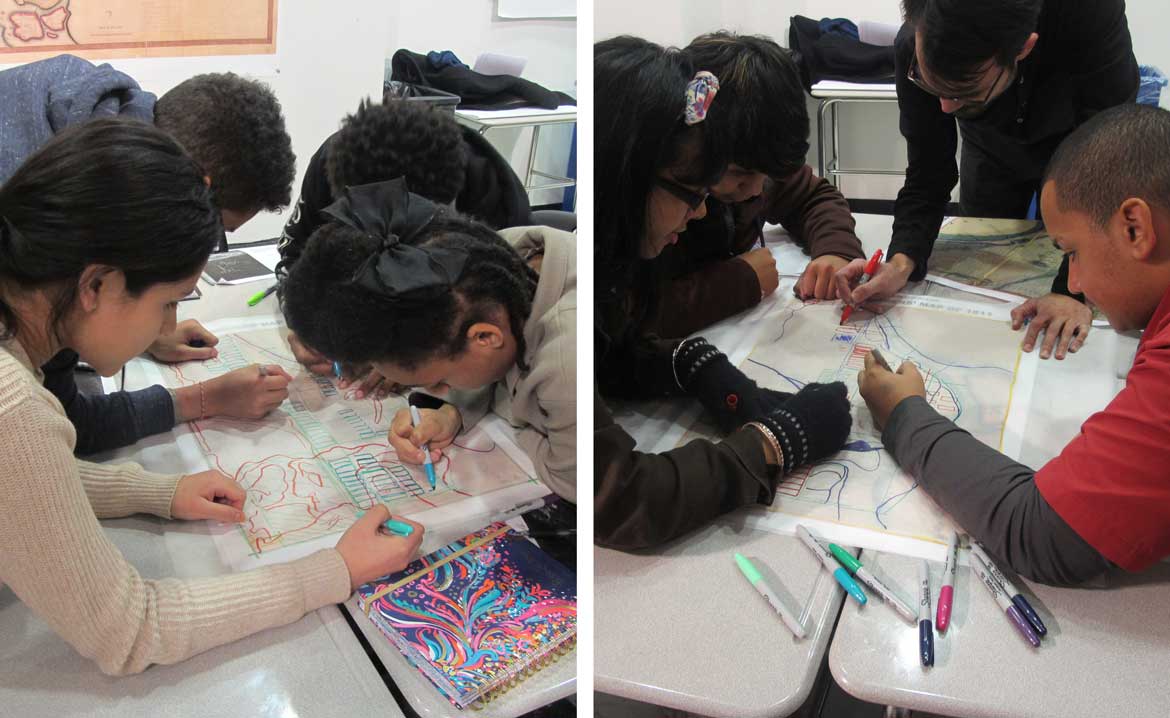
The instructors hand out tracing paper and students draw overlays of their neighborhood, starting with Viele’s waterways, followed by the grid and urban renewal areas, and ending with the 100-year floodplain. With these multi-color maps pinned to the wall, one student observes that a street they take to school used to be a stream: the Harlem Creek. Others point out that a park or public housing development they know was once a vast marsh. The observations build on one another until the class begins to notice how the old waterways and wetlands have the same boundary as the 100-year floodplain. A student observes that the same lands that would flood in a hurricane are the areas which were underwater 400 years ago. Today, that area is a busy neighborhood with housing, businesses, schools, and parks. Through this bit of time-traveling afforded by pen and tracing paper, students construct a larger climate change narrative taking place just outside their classroom window: how it came to be that one of New York City’s largest concentrations of low-income people lives in the path of coastal storm surge.
This mapping exercise is just one of the lessons that students in the Lab take part in over a semester. Six modules are led by a variety of professionals, including architects, planners, engineers, and social scientists, and activities reinforce classroom experiences with field observation. One week, students model how green infrastructure absorbs and filters stormwater run-off using paint trays, sand, and sponges. The following week, students visit James Weldon Playground in East Harlem to observe, by pouring bottled water onto the pavement and following its drainage path, how these recreation areas channel water into rain gardens. Such experiences make infrastructure design more concrete and grounded in the neighborhood, and students learn directly from design professionals they would likely never encounter during their four years in high school.
Beyond learning how climate change intersects with their everyday lives, the curriculum encourages students to take on leadership roles as advocates for resilience in East Harlem. During the East Harlem Resiliency Study, the team hosted a series of planning workshops with local non-profits, institutions, city agencies, and members of the public. At each of these, students presented their work in the Lab, sharing what they had learned about climate risk in East Harlem and the urgent need to prepare for potential disasters. Casting students in this role introduced a new dynamic to these public discussions, which were attended by many DREAM affiliates and families as well as other neighborhood residents. The message became more relatable when relayed by a community member experiencing similar day-to-day realities as others in the room; and attendees were just genuinely interested to hear from these young people who have come to see themselves as leaders in their community. One student named Alija Radoncic was even tapped for a summer internship with Manhattan Borough President Gale Brewer, where he worked with a team of college and graduate students to review resiliency policies citywide. Not yet out of tenth grade, he is advising both community boards throughout Manhattan and local emergency preparedness groups about resiliency.
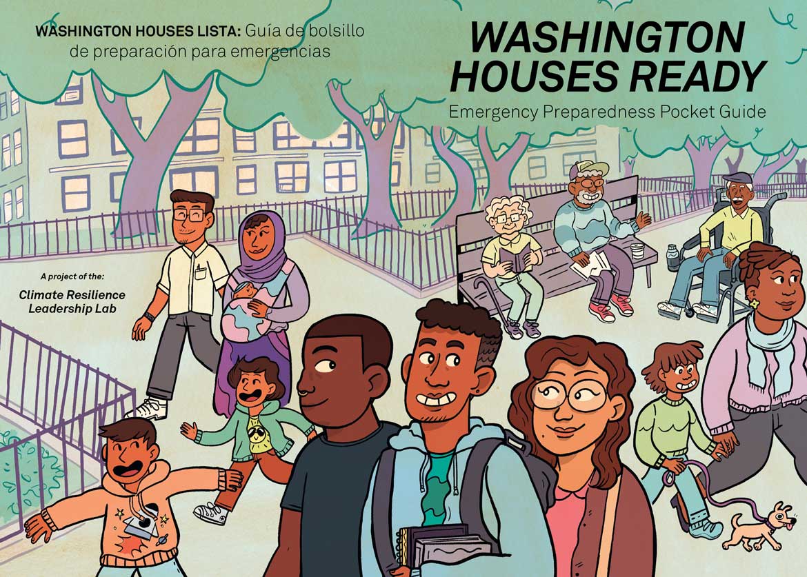
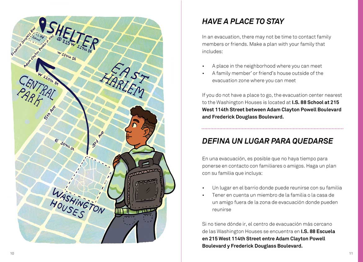
As much as the Lab supports advocacy, it is also about spurring action. About midway through the first semester in 2018, Derrick Dingle, a student in the Lab, paid a visit to Claudia Perez, the president of the Washington Houses resident council. Derrick spoke with Claudia about the Lab. He wanted to know, as a resident of Washington Houses, whether the council was doing anything to prepare for potential disasters or address climate risks. Claudia told him that she had recently polled some neighbors to see if they knew where to find an evacuation center in case of a hurricane. No one did. For Claudia, the message was clear: the first step towards climate resilience at the Washington Houses was emergency preparedness. But she still had a lot of questions: Who needs to be checked on if there is an emergency? Is anybody having problems during heat waves? Have residents experienced flooding? Together, Derrick, Claudia, and our team formulated a pilot project. Students would survey residents to get the council data it needed, and then create an emergency preparedness resource for residents. The outcome of this collaboration is “Washington Houses Ready,” a pocket guide for residents facing climate-related emergencies.
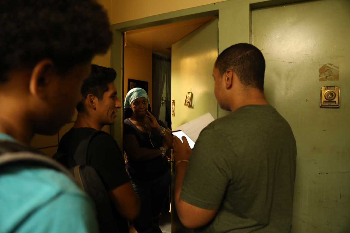
Emergency preparedness guides and resources are easily found on the Internet, so why create a pocket guide for a specific community? One reason is to frame emergency preparedness around the community’s unique qualities and assets, as documented by the DREAM students’ survey. Going door-to-door and speaking with residents in courtyards and playgrounds, the students found that about one in four households has experienced problems during heat waves, blizzards, or blackouts in the last year. By asking questions about household composition, the students learned that three social groups make up a large proportion of the Washington Houses population: seniors, children, and people with disabilities. They identified the kinds of emergencies that residents in high-rise buildings most needed information about, as well as the types of people most likely to be affected in an emergency. Putting all of this information in one place would tell a story about what emergency preparedness looks like in Washington Houses, specifically.
The cover of “Washington Houses Ready” shows a cast of characters in a courtyard, including seniors and families, and Black and Latino people, but also Chinese and Bengali residents, reflecting the shifting demographics of public housing in East Harlem. A flip through the book shows these characters taking action – installing an air conditioner, prompting emergency professionals on where to go, and checking on a neighbor. In this way, the book echoes the initiative of the people who created it, since it was young people who proposed the project in the first place, and the seniors from Washington Houses who came together to spread the word.
One way the Climate Resilience Leadership Lab has pushed the resiliency conversation in a new direction has to do with how knowledge, awareness, and advocacy are established in the context of social infrastructure. This shift was captured by a presentation given at a community forum for the East Harlem Resiliency Study by a DREAM student named Daniella Torres about why her community should care about climate change. Speaking to the adults in the room, she said: “While climate change is felt today, projections show that it will worsen. Certain projections may seem far in the future for many adults, but it’s not so far away for me. In 30 years, I’ll be 45 and hope to have my own family. While I may not be living in this neighborhood, I will have family here. It is our generation that will feel these impacts and it is our generation that needs to lead change.” Resilience is, after all, an intergenerational proposition. Cultivating informed advocates who want to make change, especially among young people who will carry this knowledge for many years to come, is one way for climate resilience to start to take root across a neighborhood community.
The authors would like to thank the many people and organizations who helped create “Washington Houses Ready.” The Pratt Center for Community Development provided funding for the pocket guide project through its Taconic Fellowship Program. Staff and team members from New York City Emergency Management and East Harlem Community Organizations Active in Disaster (COAD) contributed to discussions with Washington Houses tenants, DREAM students, and the Washington Houses Residents Council. Pratt alum Samuel Pressman ('19) supported the project through the Taconic Fellowship and JR Zuckerberg ('17) illustrated the pocket guide.
The views expressed here are those of the authors only and do not reflect the position of The Architectural League of New York.